- Class: high-altitude technical.
- Pamir, Khavraz-Dara valley.
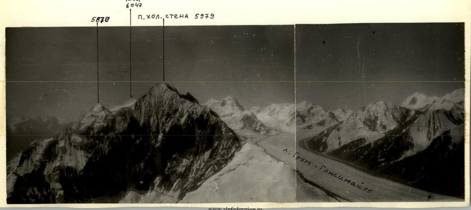
- Peak Kholodnaya стена (Cold Wall) via the center of the N wall.
- Verba's Route, 6B category of difficulty, 1983.
- Height difference: 1500 m. Distance: 1830 m.
Distance of sections:
- 1st category of difficulty — 1175 m
- 6th category of difficulty — 395 m
-
Pitons hammered in: | Rock | Nuts | Bolt | Ice | | :------- | :------- | :--------- | :------ | | 139 | 93 | 0 | 37 | There were no artificial points of support.
-
Climbing hours: 59.5; days: 6.
-
Overnights: 1–4 on a suspended platform with a tent, 5th — on a "mushroom", lying in a tent.
-
Captain: Boyko Valery Viktorovich, Master of Sports.
Team members:
- Martynov Leonid Borisovich, Candidate for Master of Sports
- Kolobaev Sergey Petrovich, Candidate for Master of Sports
- Lapin Vladimir Alexandrovich, Candidate for Master of Sports
- Misočko Oleg Viktorovich, Candidate for Master of Sports.
-
Coach: Vinokurov Anatoly Fedorovich, Master of Sports.
-
Approach to the route: July 28, 1985. Summit: August 2 Return: August 2

-
Kolomyitsev's Route, 5th place in the USSR Championship 1983, 6B category of difficulty.
-
Verba's Route, 1st place in the USSR Championship 1983, 6B category of difficulty.
-
Boyko's Route, 1985, 5B category of difficulty.
-
Klinetsky's Route, 1983, 5B category of difficulty.
Profile of the wall on the right on August 2, 16:00, shooting point #2, Mir-1Б, f=37 mm, H ≈ 5000 m, l ≈ 1.5 km.
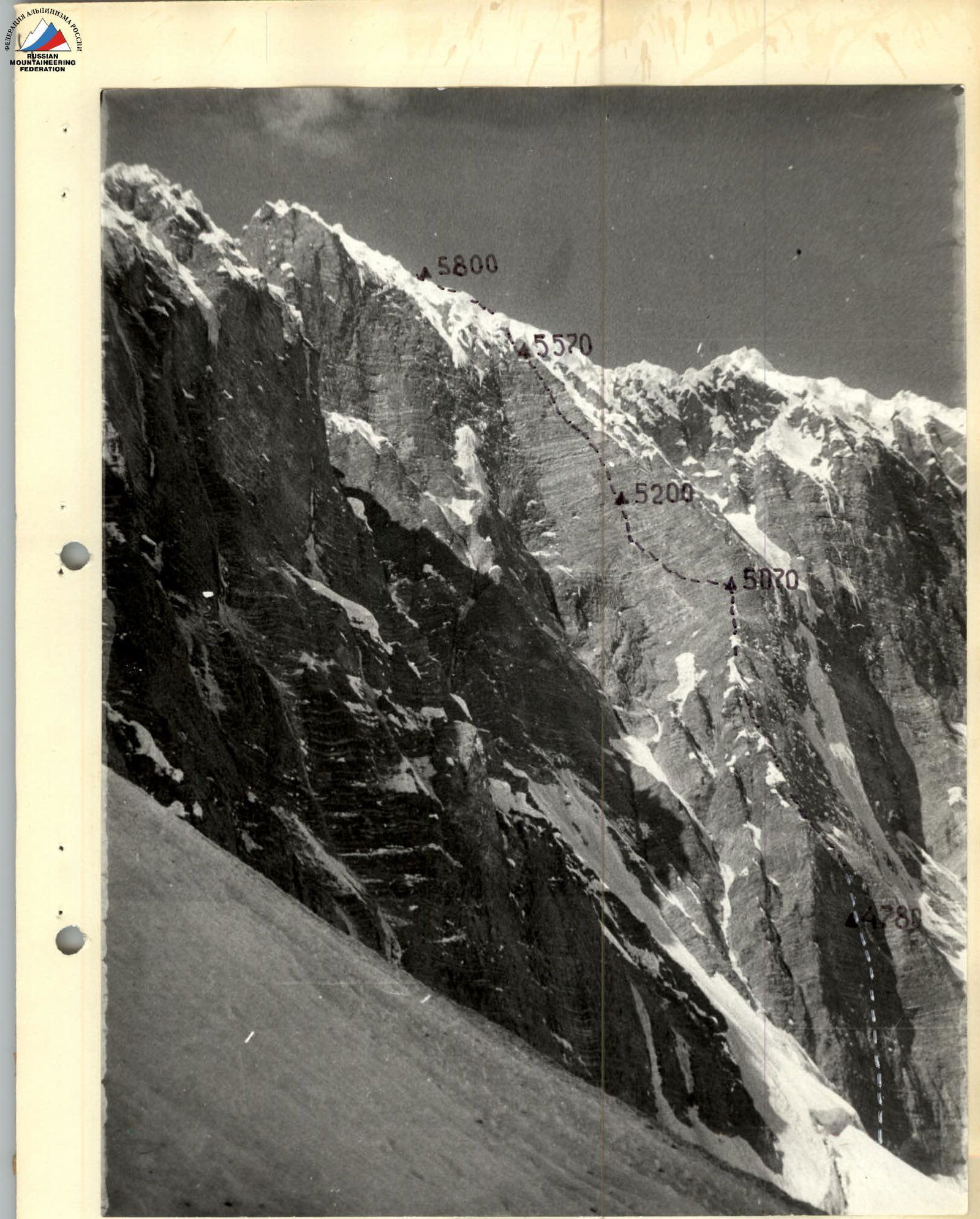
Profile of the wall on the left on July 27, 10:00, T-28, f=28 mm, shooting point #4, H ≈ 4500 m, l ≈ 0.5 km.
Photopanorama of the Chabysta area in 1985. T-43 lens, f=40 mm, shooting point #3, H=5600 m, l ≈ 5 km.
Tactical Actions of the Team
The tactical plan provided for passing the route with five nights:
- one in the upper part of the 1st bastion,
- three on the 2nd bastion,
- one on the rib.
The planned tactical plan was executed.
Organization and change of rope teams, change of leaders: we didn't really have rope teams. In the evening, we determined the first, second, and last, and the rest moved as they were ready.
- Day 1 (R1–R6): Boyko, Martynov, last — Misočko
- Day 2 (R7–R14): Boyko, Martynov, Lapin
- Day 3 (R15–R18): Martynov, Boyko, Kolobaev
- Day 4 (R19–R24): Martynov, Boyko, Misočko
- Day 5 (R25–R26): Boyko, Martynov, Lapin
- Day 6 (R27–R29): Boyko, Lapin, Misočko
Usually, we change the leader every other day, but this time we planned Martynov to be the first on the 2nd bastion, and therefore the leaders changed less frequently. Excellent preparation allowed us to conduct this experiment without issues. Moreover, the second was always ready to replace the leader if necessary. The second often straightened the fixed ropes.
Preliminary processing: we processed little.
- 1 rope above bivouac #1 (R7, Boyko)
- 2 ropes from bivouac #3 (R19–R20, Martynov)
- 1 rope from bivouac #4 (R27, Lapin)
- 1 rope from bivouac #5 (R27, Boyko)
Fixed ropes were organized along the entire route. The first climbed on a 2nd rope, and all subsequent ones — on fixed ropes with top-rope belay. Backpacks were usually carried, but were pulled up in a few difficult places.
Movement regime: the platform allowed us to move evenly, practically throughout the daylight, without worrying too much about choosing convenient places and leaving time for organizing a bivouac. Time required to prepare the platform — 30–60 min. The main criterion for choosing a bivouac site was safety. On section R2, we waited for two hours for the sun to stop illuminating the wall and the rockfall intensity to decrease.
Safety measures: the first climbed the entire route without a backpack, on a 2nd rope. Belay through shock absorbers. All subsequent climbers moved on two jumar ascenders on fixed ropes and only with top-rope belay. Fixed rope anchor points were chosen under overhangs, often at the expense of convenience. Constant observation of rockfall was carried out. And yet, the main measure that allowed us to pass without injuries during the earthquake should be considered the careful, competent work of the entire team, and especially the first.
There were no falls or injuries. Communication with observers was visual and in the evenings — with light signals using a flashlight.
We didn't have radio communication, as the radio was broken by a rock on the first day.
Route diagram in symbols. Scale 1:2000
| RCP | ZKL | AEA |
|---|---|---|
| 2 | 1 | |
| 3 | 3 | |
| 3 | 2 | |
| 2 | 1 | |
| 3 | 2 | |
| 8 | 5 | |
| 10 | 4 | |
| 6 | 4 | |
| 7 | 4 | |
| 4 | 4 | |
| 3 | 2 | |
| 3 | 2 | |
| 5 |
| RCP | ZKA | LEA |
|---|---|---|
| 9 | 8 | |
| 5 | 3 | |
| 7 | 7 | |
| 10 | 7 | |
| 5 | 4 | |
| 9 | 5 | |
| 5 | 3 | |
| 4 | 2 | |
| 8 | 5 |
Description of sections R1–R29:
| Section | Length, m | Angle, ° | Category of difficulty |
|---|---|---|---|
| R1 | 40 | 70 | V |
| R2 | 30 | 75 | V |
| R3 | 25 | 90 | VI |
| R4 | 65 | 80 | V |
| R5 | 40 | 91 | VI |
| R6 | 70 | 85 | V |
| R7 | 70 | 80 | V |
| R8 | 30 | 75 | V |
| R9 | 30 | 60 | IV |
| R10 | 30 | 80 | V |
| R11 | 30 | 85 | V |
| R12 | 30 | 60 | IV |
| R13 | 90 | 75 | V |
| R14 | 40 | 80 | V |
| R15 | 40 | 80 | V |
| R16 | 45 | 90 | VI |
| R17 | 40 | 85 | V |
| R18 | 80 | 80 | V |
| R19 | 50 | 91 | VI |
| R20 | 30 | 90 | VI |
| R21 | 70 | 91 | VI |
| R22 | 65 | 91 | VI |
| R23 | 40 | 89 | V |
| R24 | 60 | 80 | V |
| R25 | 160 | 55 | V |
| R26 | 130 | 60 | V |
| R27 | 150 | 55 | V |
| R28 | 40 | 60 | V |
| R29 | 200 | 40 | III |
Brief description of the route by sections
When approaching the wall, a triangular spall is visible in the lower left part. The start of the route is somewhat to the left on ice, overcoming the bergschrund and exiting onto the spall.
R1: The bergschrund wall and then the ice slope are traversed in crampons on ice axes. R2: The rock wall is destroyed. It is traversed upwards to the right. R3: A sheer wall. Holds are like "reverse tiles". R4: A crack and an internal corner. The general direction is up to the right. Pitons and small nuts go well. R5: A wall with a cornice. There are holds. It is traversed by free climbing on the right part. R6: There are sections with rime ice. There is a lot of "lively" rock. One must be extremely cautious. R7: The wall is destroyed. Then to the left along the rib. There are holds. R8: A wall with pleasant climbing. R9–R11: Movement along the rib. R12: The "mushroom" is traversed left — down. R13: Several walls with transitions. R14: A wall with an exit to an inclined shelf. R15: A wall with "reverse tile" holds. Movement is left upwards. R16: A smooth wall with an overhanging internal corner. Exit to a shelf with snow. R17: A wall, "reverse tile". R18: A destroyed internal corner, a smooth wall, and split slabs. Exit to an inclined shelf. Then — a cornice. R19: The cornice is traversed by climbing on the right part. Then a wall, "reverse tile". R20: A cornice and an exit to a small shelf for two people. R21: An overhanging wall with cornices. It is surprising, but Martynov climbed it by free climbing. Exit to a shelf. R22: An internal corner with a cornice. Movement is left upwards. R23: A destroyed wall. R24: An internal corner with rime ice. Exit to a couloir, ice wall to the left of the rib. R25: An ice slope, to the right around the "mushroom" and another ice wall. The second "mushroom" is circumvented in a zigzag from right to left. R26: An ice-rock couloir. One can hammer in pitons. R27: An ice-firn slope. Movement is to the left of the rib. R28: Circumventing the "mushroom" on the left. Practically straight up the ice wall — exit to the ridge. R29: An intricate ridge with drifting snow cornices. The summit.

Photo #4. Passing fixed ropes on section 15–17.
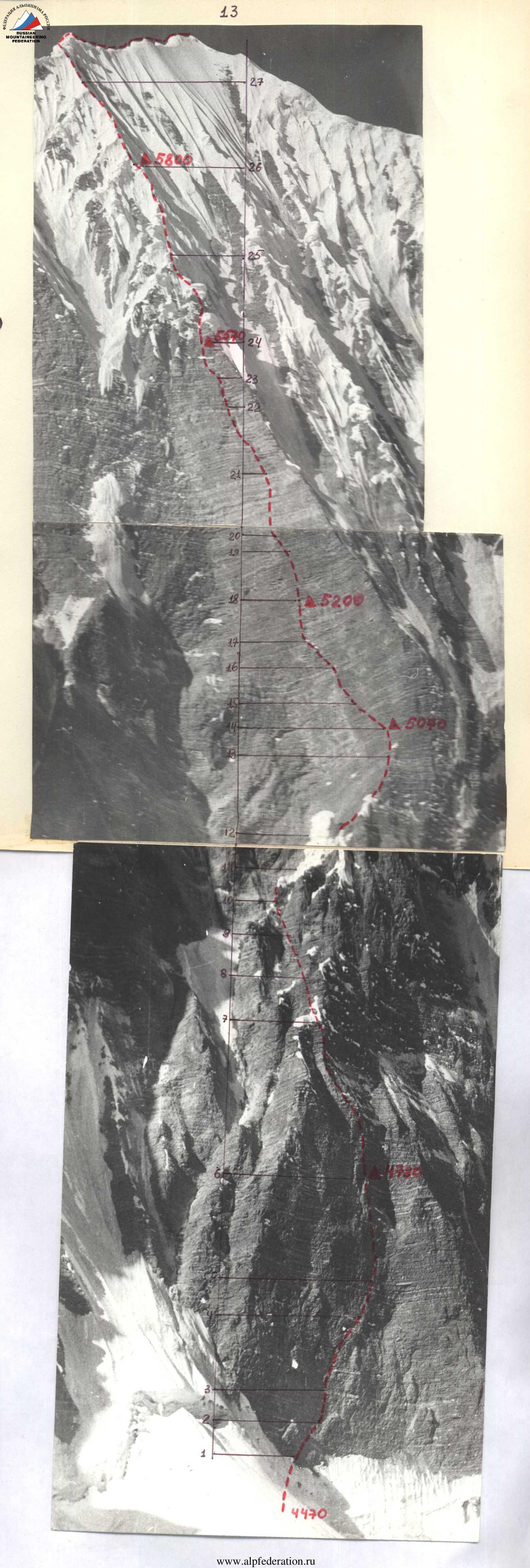
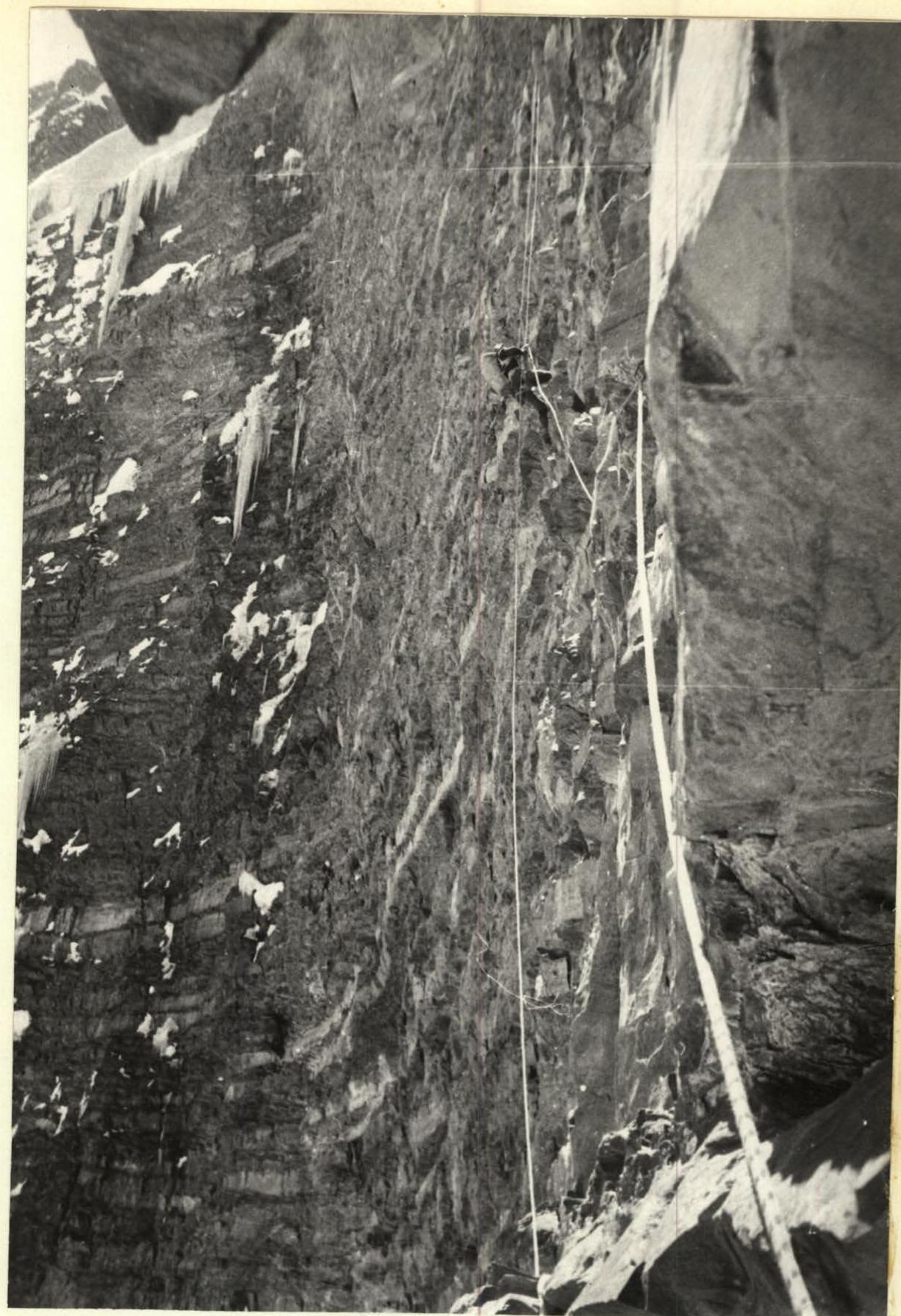
Photo #6. Passing fixed ropes on section 20–21 (upper part of the second bastion)