-
Climbing category: high-altitude technical.
-
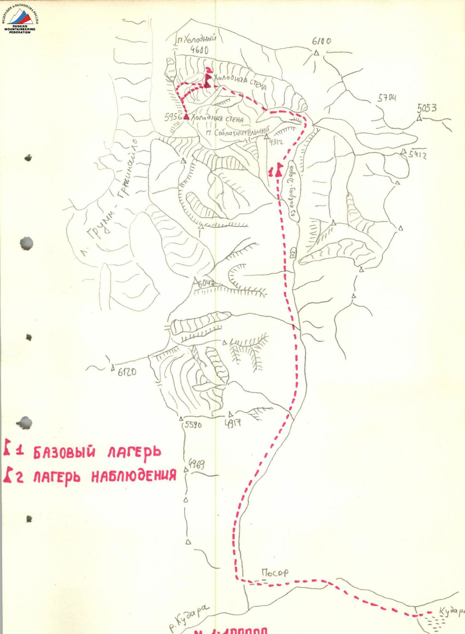
Climbing area: South-Eastern Pamir, Yazgulem Ridge, Khovraz-Dara valley.
-
Summit: Pik Kholodnaya Stena (5959) via the right bastion of the north face.
-
Assumed category: 5B (first ascent).
-
Route characteristics:
- combined route
- total elevation gain: 1500 m
- wall section elevation gain: 1100 m
- ridge elevation gain: 400 m
- total route length: 3770 m
- wall section length: 1620 m
- ridge length: 2150 m
- sections with 5B category: 480 m
- lower wall slope: 37°
- upper wall slope: 71°
- average wall slope: 51.5°
- ridge slope: 10°
-
Pitons used:
| Type of pitons | Rock | Bolt | Nuts | Ice screws |
|---|---|---|---|---|
| Quantity | 81 | 0 | 8 | 19 |
| Spent | 6 | 0 | 0 | 1 |
-
Climbing hours: 32 hours, days: 3.
-
Overnights: 2 in a tent.
-
Klineckij E.F. — (leader, Candidate for Master of Sports) Mikhailov S.V. — (participant, Candidate for Master of Sports) Plotkin M.E. — (participant, 1st sports category) Sukhov V.S. — (participant, 1st sports category)
-
Bashkirov V.L.
-
Departure: August 18, 1983. Return: August 20, 1983.
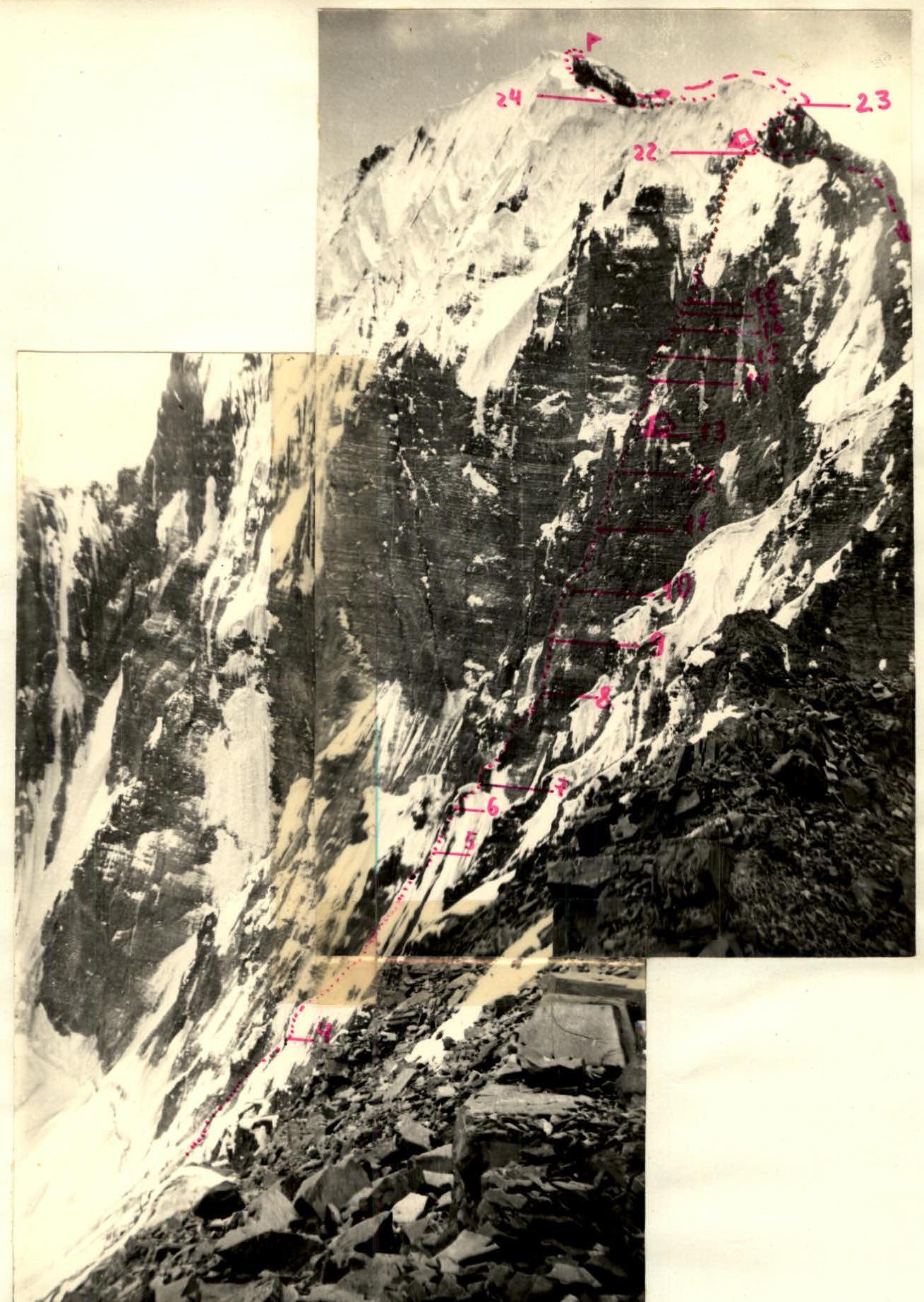
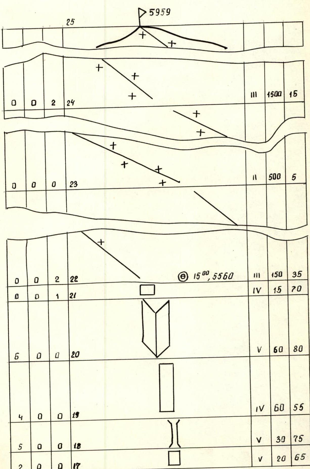
Route profile
- visible part of the route
- invisible part of the route
- descent path route point numbers
- overnight locations
- photo taken with "SMENA-8" camera
Tactical actions of the team
August 18, 1983. Early in the morning, at 5:00, the group started moving along the snow-ice slope. The rope team Plotkin — Sukhov passed the first ice section, leaving ice axes for the second team for belay. To increase the speed of movement, the lower part of the ridge (R2–R4) was traversed by independent rope teams. The first team left belay points for the second team. Starting from point R4, full interaction between the teams was established. All participants, except the first, climbed using a fixed rope.
On sections R4–R13, the first team was Klineckij — Mikhailov. To pass the combined part of the route, Mikhailov put on crampons. The alternating system of ice and rock walls was traversed by constantly changing the leader: Mikhailov went on ice; Klineckij on rocks. This allowed maintaining a good speed of movement according to the tactical plan.
The team reached the overnight location at 19:00. Before that, the route allowed only a sitting overnight under the bastion on an inclined ledge, unprotected from rocks. They spent the night in a tent.
August 19, 1983. Work according to plan. The team of Plotkin — Klineckij went ahead. The rocks were partially covered with snow. There were sections with ice. Exit to the ridge. According to consultations, the ridge was ice-rock, with a predominance of ice sections. The group took only necessary equipment, warm clothes, and started moving towards the summit. Summit. Descent and overnight in a tent at the location where the group exited the ridge.
August 20, 1983.
- Descent to observers on the glacier under Pik Kholodnaya Stena.
- Return to camp.
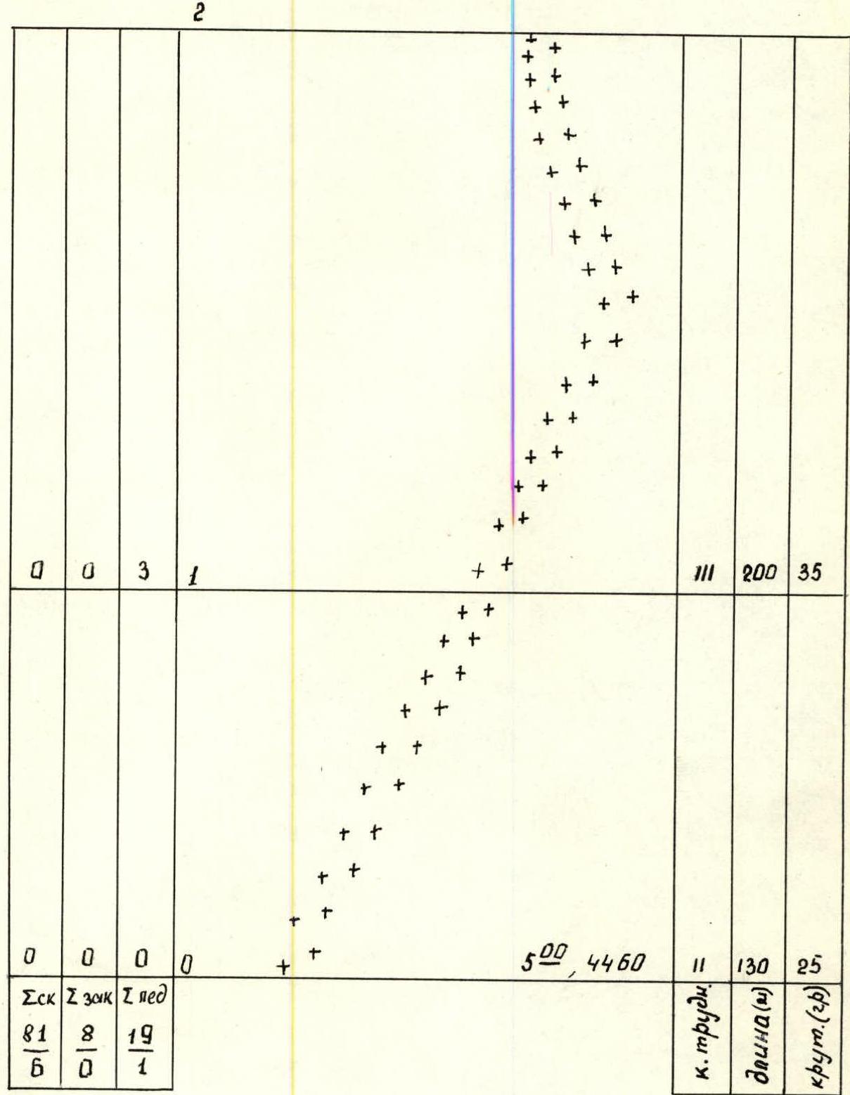
Route diagram in UIAA M symbols 1:2000
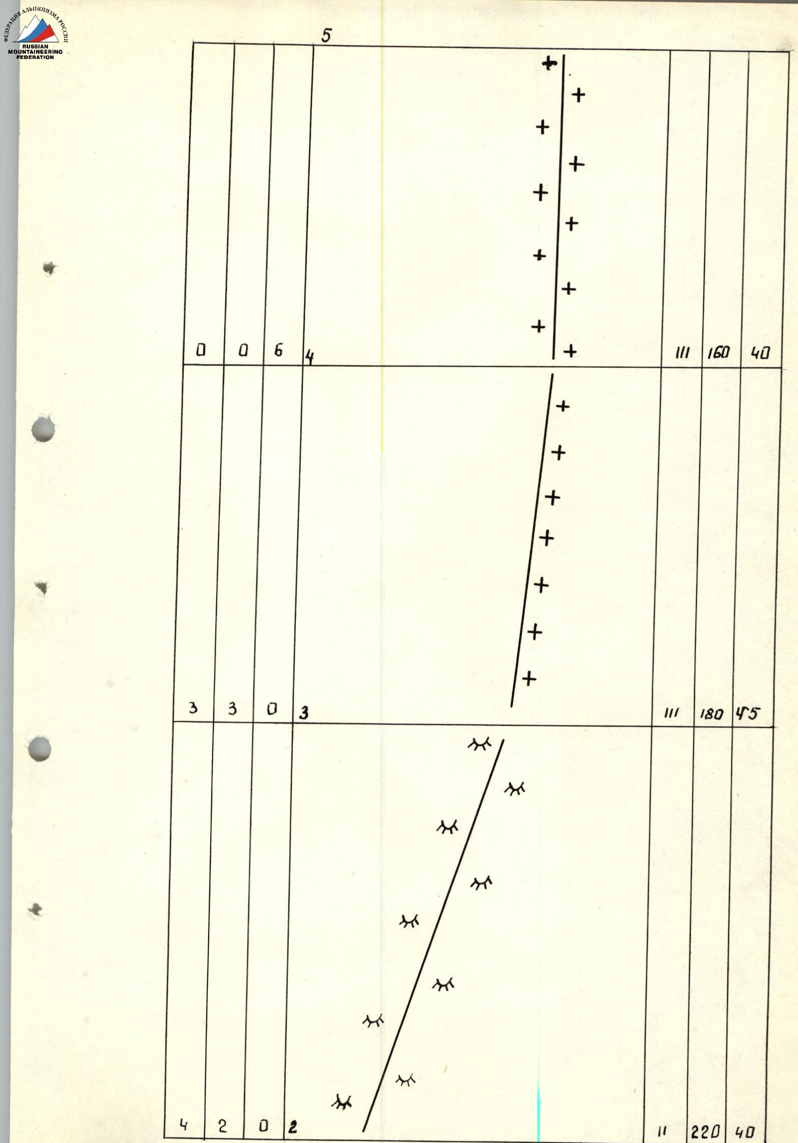
| Pit. (1) | Pit. (2) | Pit. (3) | Section | Category | Length (m) | Slope (°) |
|---|---|---|---|---|---|---|
| 4 | 0 | 1 | R5 | V | 40 | 75 |
| 1 | 0 | 4/1 | R6 | V | 40 | 75 |
| 4 | 0 | 0 | R7 | IV | 40 | 70 |
| 4 | 0 | 0 | R8 | IV | 80 | 60 |
| 9/3 | 1 | 0 | R9 | V | 60 | 85 |
| 9/1 | 1 | 0 | R10 | V | 40 | 80 |
| 7/2 | 0 | 0 | R11 | V | 40 | 75 |
| 6 | 0 | 0 | R12 | V | 40 | 70 |
| 9/1 | 1 | 0 | R13 | V | 80 | 75 |
| ¾ | 0 | 0 | R14 | IV | 25 | 60 |
| 4 | 0 | 0 | R15 | V | 30 | 80 |
| 3 | 0 | 0 | R16 | V | 30 | 60 |
| 2 | 0 | 0 | R17 | V | 20 | 65 |
| 5 | 0 | 0 | R18 | V | 30 | 75 |
| 4 | 0 | 0 | R19 | IV | 60 | 55 |
| 6 | 0 | 0 | R20 | V | 60 | 80 |
| 0 | 0 | 1 | R21 | IV | 15 | 70 |
| 0 | 0 | 2 | R22 | III | 150 | 35 |
| 0 | 0 | 0 | R23 | II | 500 | 5 |
| 0 | 0 | 2 | R24 | III | 1500 | 15 |
| R25 |
Notes: To section R13: 8:00, 5340 m; 19:00, 5340 m. To section R22: 15:00, 5560 m. To section R25: Summit 5959 m.
Route description by sections
R0–R2. Snow-ice slope with a bergschrund. The bergschrund is overcome via a snow bridge. The section should be traversed in crampons. R2–R3. Destroyed rocks. Alternating ledges and walls (2–4 m). The section ends with an exit to a wide ridge. R3–R4. Movement along the ridge along the border of rocks and ice. R4–R5. Snow-ice ridge traversed in crampons. R5–R9. Ridge with ice walls. Mainly traversed on the right part. Ice is hard. Exit to a large inclined ledge before the bastion. R9–R10. Beginning of the bastion — traverse on the left part, to the left edge of the bastion. Sections R9–R21 were traversed in crampons or galoshes. R10–R13. To the right of the bastion edge along the walls. Move left from the edge into a chimney (dangerous — rocks!). Exit to the first overnight location. R13–R14. Traverse left — crossing the chimney and further right upwards, bypassing the baldy. R14–R18. Along the system of walls — bypassing snow caps-mushrooms on the left. R18–R19. The chimney leads to the base of a gully leading to the ridge. R19–R22. Along inclined slabs to the right part of the gully, traverse, and along the left wall of the gully — exit to the ridge. Attention: rocks! On the ridge — second overnight location. R22–R25. First along a rocky, and then a snow-ice ridge to the summit. Crampons necessary.
Descent initially follows the ascent path from the summit to the exit to the ridge. Further along the same ridge to the Kholodnaya Stena glacier.
