Passport
I. Class of first ascents 2. Pamir, Havraz-Dara valley 3. Peak "Kholodnaya Stena" via the bastions of the left part of the East wall 4. Assumed 5B category of difficulty, first ascent. 5. Elevation gain 1619 meters.
Average slope up to the ridge — 68°. Average slope up to the summit — 65°. Average slope of sections R23–R24 — 85°. R42–R48 — 85°.
- Piton placement
| rock | bolt | chock | ice |
|---|---|---|---|
| 274 | 0 | 99 | 49 |
| 8 | 2 | 0 | 0 |
-
Climbing hours of the team — 66.5. Days — 6.
-
Overnights: — R1 and R4 — on a rock shelf: 2 people in a tent and 2 people in different places. — R2, R3, R5 — on snow (on the ridge or snow "mushroom") in a tent.
-
Team leader: Opoytsev Nikolay Anatolyevich — Candidate Master of Sports Team members: — Temirov Mukhamed Magometovich — Candidate Master of Sports — Pavlenko Viktor Vasilievich — Candidate Master of Sports — Viktorov Yury Borisovich — Candidate Master of Sports
-
Coach: Korsun Anatoly Grigoryevich — Master of Sports
-
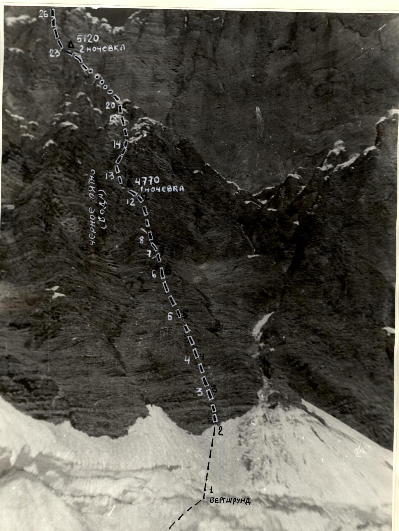
Departure to the route: July 30, 1985. Summit: August 4, 1985. Return: August 5, 1985. General photo of the summit
 — 1 — Shumilov's route
— 2 — V. Solonnikov's route
— 3 — V. Kovtun's route
— 4 — Route climbed by the team
Δ — Overnight locations with elevation marks.
Taken with a "Weika" camera, F = 8 cm. Date taken: August 29, 1985. Distance to the subject — 1.5 km. Shooting point No. 1. Elevation of the shooting point 4360 m.
— 1 — Shumilov's route
— 2 — V. Solonnikov's route
— 3 — V. Kovtun's route
— 4 — Route climbed by the team
Δ — Overnight locations with elevation marks.
Taken with a "Weika" camera, F = 8 cm. Date taken: August 29, 1985. Distance to the subject — 1.5 km. Shooting point No. 1. Elevation of the shooting point 4360 m.
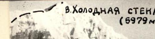
Photo of the wall profile from the left.
Taken with a "Smena" camera from the summit "520". F = 4 cm, lens T-22. Distance to the subject — 1.2 km.
Shooting point No. 2. Photopanorama of the area

— Shumilov's route — V. Solonnikov's route — V. Kovtun's route — Route climbed by the team
Δ — Overnight locations and their elevations
Shooting point No. 4. Date taken: July 29, 1985. Camera "Vilia", lens T-22, F = 4 cm. Distance to the subject — 2 km. Elevation of the shooting point — 4360 m.
Brief overview of the climbing area
Peak "Kholodnaya Stena" (5979 m) is located in the South-Eastern Pamir region in the Yazgulem range between the Grum-Grжимайло glacier and the Havraz-Dara valley. The summit is significantly remote from the Pamir tract "Osh — Khorog" — approximately 150 km. The summit became an object of ascents in 1980. All routes were claimed and climbed on the East wall.
For the route on the left part of the East wall, the team from the Ukrainian "Burevestnik" led by V. Kovtun took the I place in the USSR Championship in the high-altitude technical class. The team from the Leningrad "Trud" led by V. Solonnikov — for the route on the right part of the wall — II place. The third route led by Sh. Shumilov was laid to the right of the Leningraders.
The route climbed by the team is a logical addition to the series of routes on the East wall of peak "Kholodnaya Stena".
Like previous climbers, the group noted the great steepness of the rocks, their destructiveness, and the difficulty of passing hanging snow caps — "mushrooms".
Unlike the previous three routes, the route climbed by the team is less prone to rockfall — its key section — the "Big Bastion" — being part of the wall, is set back from it. The team was able to observe the most rockfall-prone sectors along the entire East wall from a safe distance.
A more detailed overview of the climbing area is provided in the reports of the first ascenders — teams led by V. Solonnikov and V. Kovtun (1980).
Tactical actions of the team
The tactical plan provided for the team to complete the route in 6 days.
Focusing on the results of previous teams that had climbed the lower bastions (up to the wall section) in 2 days, the team planned:
— 3rd day — processing the route up to the Big Bastion; — 4th day — climbing the Big Bastion; — two days — climbing the pre-summit bastions with snow "mushrooms", ascent to the summit, and beginning of descent.
The planned tactical plan was fully executed (see the ascent graph on p. 6-rev.).
In 3 days, the team climbed the lower bastions.
— The third overnight stay was under the Big Bastion. — The fourth overnight stay — in the middle of the Big Bastion — plus processing part of the route. — The fifth and sixth days of the ascent were spent processing the pre-summit bastions, reaching the ridge, then the summit, and descending.
Work by day for the lead climbers:
— 1st day — lead — N. Opoytsev — 2nd day — lead — V. Pavlenko — 3rd day — lead — N. Opoytsev — 4th day — lead — Yu. Viktorov — 5th day — leads — M. Temirov, N. Opoytsev — 6th day — lead — V. Pavlenko
The group climbed the entire route without prior processing, except for hanging two ropes across the bergschrund in the evening before the ascent.
Throughout the route, the safety rope was securely attached — at least to three blocked pitons. There were no cases of piton pull-out.
The movement regime was organized as follows:
— The group started moving no later than 8:30 to 9:00. — By the end of the working day, the overnight location was determined. — If the location was convenient, from 17:00 to 18:00 the group would set up camp, and a team of two would continue working.
The overnight stays were good. All team members had a full rest.
There were no falls or injuries on the route. The problematic task on the route was passing the "Snow mushrooms" — overhanging and vertical sections of loose, crumbly snow. The task was solved as follows:
- A reliable lower belay was organized.
- Since the lower part of the "mushrooms" was thawed and icy — ice screws were used in combination with ladders.
- By removing a certain layer (from 0.3 to 1.0 m) of snow, it was possible to use the axe handle as a foothold.
- Digging trenches and careful treading of snow were also used.
- After passing the "mushroom", a reliable belay "station" was organized — either on a rock ledge or on accretion ice.
Communication with observers was carried out regularly via the "Vitalka" radio station (see observation log).
Description of the route by sections
R0–R1. Approach to the start of the route. Snow, firn — crevasses form on the glacier. Overcoming the bergschrund — 10 m overhanging ice wall. Ice screws are necessary. R2–R12. Rocks III–V category of difficulty. Particular attention should be paid to "live rocks". It is necessary to organize safe (under cover) belay stations. R12–R13. Complex V category of difficulty climbing. Due to the high destructiveness of the rocks, it is difficult to find a place to hammer in pitons, but small-sized chocks fit well. On the shelf — a good overnight stay. R13–R14. Rocks smoothed by water. It is better to climb in the morning when there is no water. R14–R15. Careful climbing is necessary. Many "live rocks". R15–R23. Climbing IV–V category of difficulty. Not particularly complex. On the snowy ridge — a convenient place for an overnight stay. R23–R24. Vertical wall 50 m. Use of ladders. R25–R27. Passing a chimney. Many "live rocks". R31–R37. Passing a series of rock walls in combination with snow "mushrooms". Tactics for overcoming "mushrooms" — see "Tactical actions of the team". R38–R40. Exit to the snowy ridge. On the ridge — a large snow "mushroom", bypassing which is undesirable. Rappelling and diagonal traverse through a couloir — saves time. R42–R43. Beginning of the Big Bastion. While processing it, the group can be under the protection of a snow-ice "mushroom". Rocks are complex, many "live rocks". R43–R44. One rope to a good shelf. Overnight stay location — good. Rocks are complex, destroyed. Simultaneous work on sections R43–R44 and R44–R45 is undesirable. R44–R48. Two and a half ropes — continuation of the bastion. Large chocks are well-applied. R48–R50. Snow-ice ridge. Bypass to the left. Crampons are necessary for everyone. R52–R54. Snow-ice ridge. Belay via ice screws. R54–R55. Complex combined wall. There is an overhanging snow-ice visor. Receiving station — under an ice "mushroom". R55–R56. Passing a "mushroom". Digging a trench was used. Good overnight stay. It is necessary to prepare the site.
R56–R57. Complex passage of a "mushroom". Digging a trench is undesirable, as it increases the overhang of the "mushroom" cap. One can use boosting with ice screws and an ice axe. R57–R64. Six ropes (40 m each) of combined climbing. Four couloirs are crossed in the direction of a gap in the ridge. R64–R66. Destroyed rocks. Alternating work of the first and other team members is necessary to avoid knocking off rocks. R66–R68. Exit to the ridge. Overcoming an overhanging snow-ice cornice. Use of ice screws with a ladder. R68–R69. Simple ridge. Simultaneous movement along convenient shelves. Approximately 1 hour to the summit.
Technical photo of the route (lower part)
Taken with a "Zenit" camera, lens T-22, F = 4 cm. Point No. 3, distance to the subject 500 m.