
PASSPORT
- High-altitude class
- Central Pamir, Yazgulemsky Range
- Pik Revolyutsii, 6974 m, via NW wall (Cherevko route), 2nd ascent
- Category 6B
- Route characteristics:
| elevation gain | 1530 m | |
| length | 3800 m | |
| length of sections with category 5–6 difficulty | 490 m | |
| average steepness of the main part of the route | 61° / 5250–6800 m / | |
| including category 6 sections | 78° / 5760–6080 m /, 77° / 6230–6420 m / |
- Pitons hammered:
| rock | placements | ice |
|---|---|---|
| 96 / 3 | 62 / 2 | 23 |
-
Team's total climbing time: 54 hours, 4 days
-
Night bivouacs:
- 1st lying,
- 2nd sitting,
- 3rd semi-reclining,
- 4th lying.
-
Team leader: Igor K. Korenyugin, Candidate Master of Sports
Team members:
- Yuri A. Gaydamakin, 1st category
- Eduard F. Zaev, Master of Sports
- Vladimir E. Meshcheryakov, Candidate Master of Sports
- Vasily V. Novikov, Candidate Master of Sports
- Mikhail T. Sundeev, Candidate Master of Sports
-
Coach: Eduard F. Zaev
-
Departure to the route: August 12, 1989 Summit: August 15, 1989 Return: August 17, 1989
-
Voronezh Regional Sports Committee.
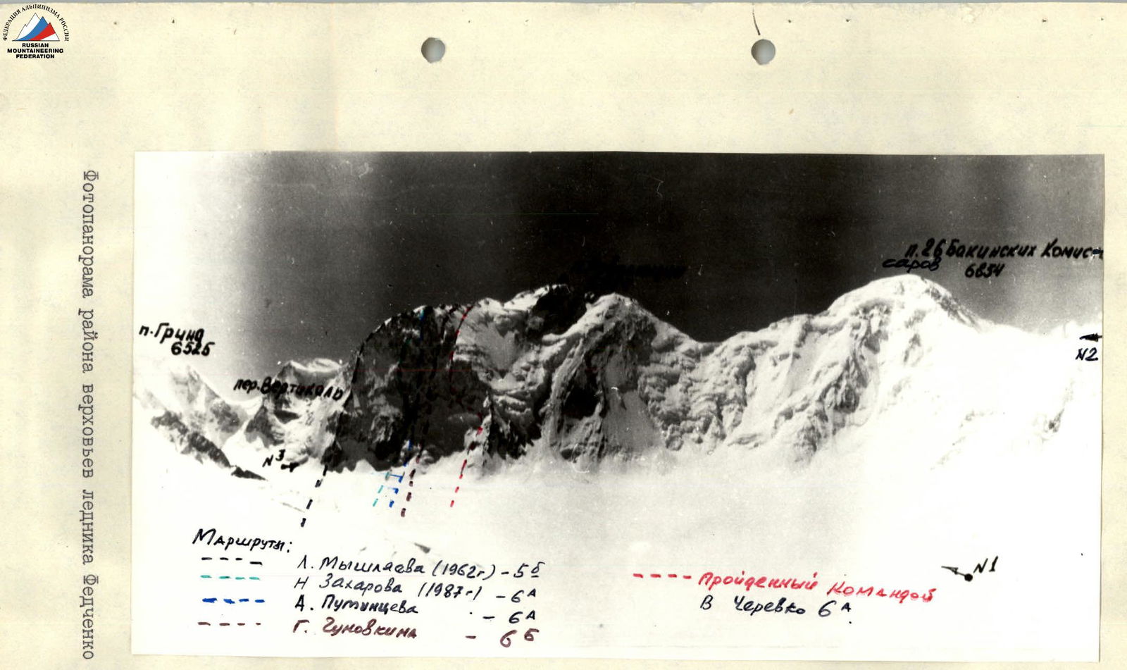
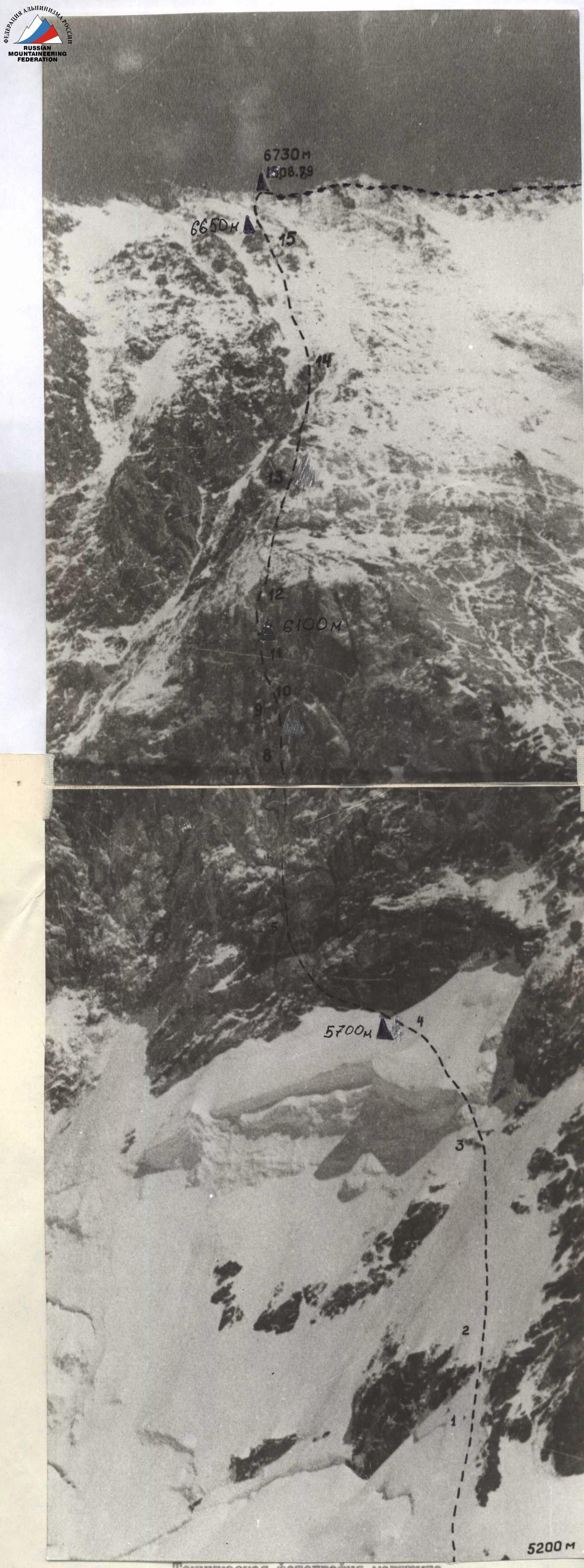
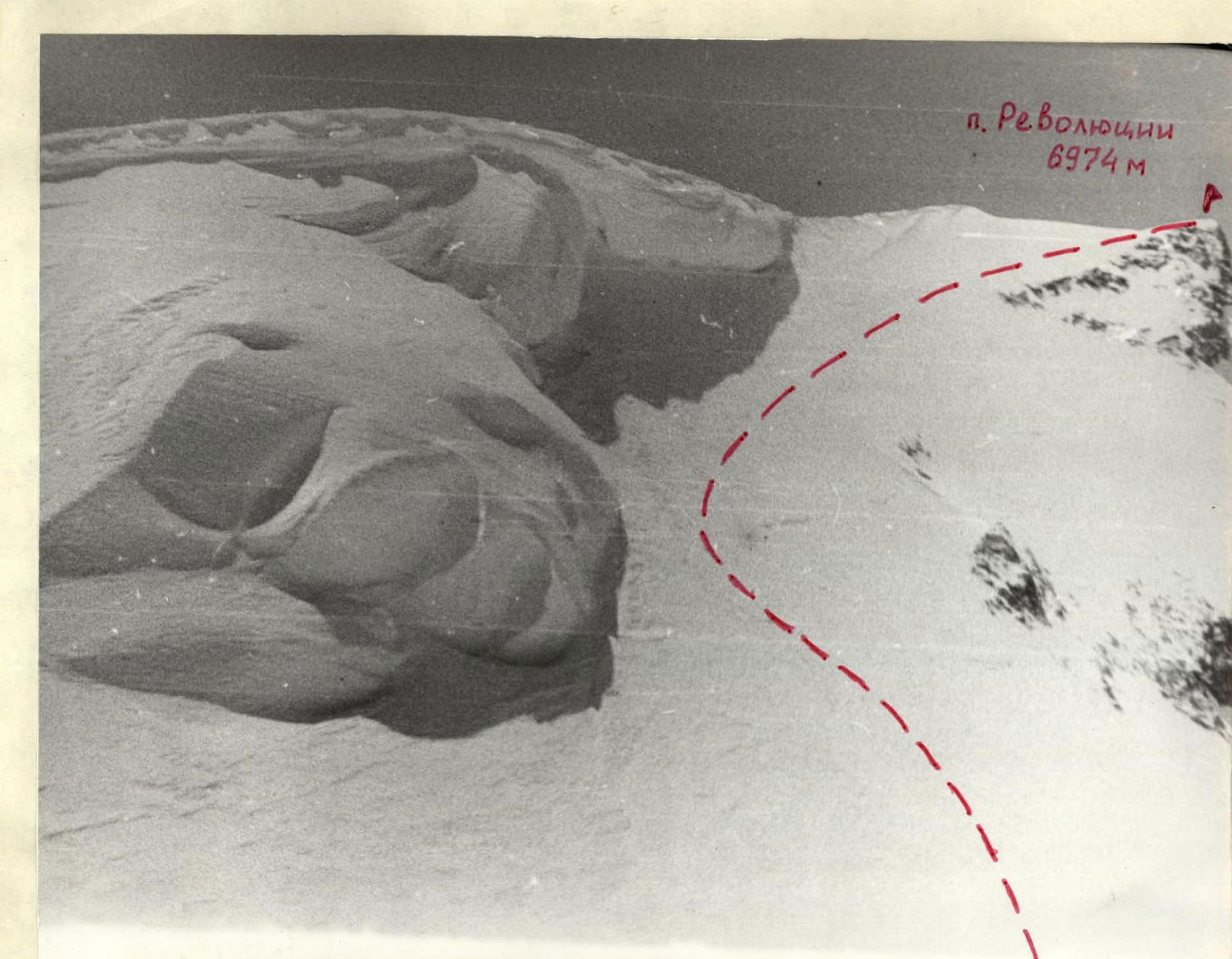
General photo of the summit. Taken on August 6, 1989 at 16:00. "Industar" lens, F=50 mm. Shooting point #1, distance 4.5 km, elevation 5250 m.
Routes:
— L. Myshlyaev (1952)
— A. Putintsev
— N. Zakharov
— G. Chunovkin
— V. Cherevko, ascended by the team.
Profile of the NW wall of Pik Revolyutsii on the right. Photo taken from the SW ridge of Pik 26 Baku Commissars.
Profile of the NW wall of Pik Revolyutsii on the left.
Tactical actions of the team
The tactical plan for the ascent included the following actions:
- The ascent would be undertaken by a group of 6 people with one tent;
- For safety reasons, the lower snow and ice part of the route would be traversed without a bivouac in one day without prior processing;
- To have a reserve of ropes for processing and traversing the "key" section of the route - a 450-meter rock "triangle";
- To have the necessary equipment for a possible sitting bivouac;
- To complete the ascent in 6 days, with 4 days allocated for traversing the route to the summit and 2 days for descent;
- To have a reserve of food and fuel for 2 days in case of bad weather;
- Due to unstable weather in the area, to strive to minimize the duration of the ascent, making full use of daylight.
As a result of the ascent, the planned tactical plan was fully executed by the team.
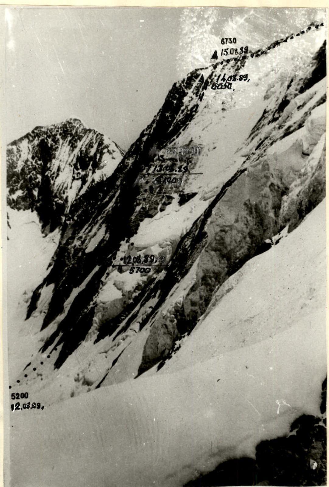
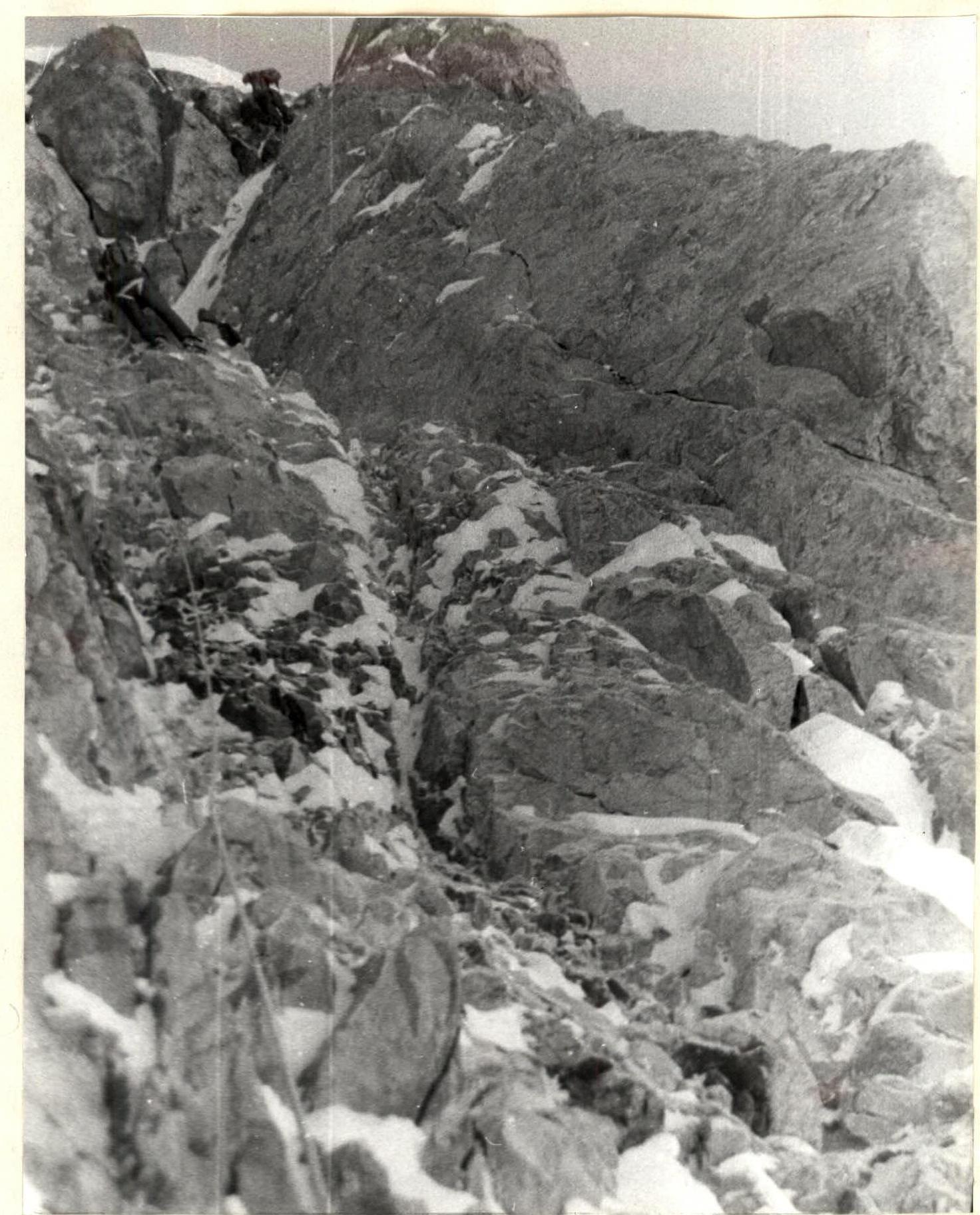
On the first day of the ascent, August 12, 1989, the Korenyugin-Novikov team worked ahead (section R0-R3), and later Gaydamakin-Zaev (section R3-R4). The snow and ice part of the route (photo 1) was traversed with insurance through ice axes and ice screws. At the start of section R3-R4, ice screws were used. The night bivouac was organized in a snow pocket under the overhanging wall at the base of the "triangle". On the same day, the Novikov-Sundeev team traversed two more rope lengths (section R5-R6) and descended to the night bivouac by 20:30.
The entire second day, August 13, 1989, was spent by the Korenyugin-Gaydamakin team on section R6-R11. This day required great effort from all team members, as this part of the route was the key section and presented steep rocks composed of light, brittle rocks resembling sandstone. This required great caution from the team: the lower team members moved only when there was no possibility of falling rocks from above.
Stations for reception and insurance were set up using 2-3 rock pitons. Placement elements were widely used for intermediate insurance. In 4 places, artificial anchors were used. A safe location was chosen for the night bivouac in a crack. The team bivouacked sitting, sheltered by a tent. The weather was good.
On the third day, August 14, 1989, Gaydamakin worked first, teamed with Korenyugin. He traversed the remaining half-rope length to the top of the "triangle" (section R11-R12). The rest of the day was spent traversing inclined slabs resembling "sheep's foreheads", covered with deep snow. Insurance was provided through:
- ice screws,
- rock pitons,
- placements.
There were still 2-3 rope lengths to the pre-summit ridge when the team had to stop for a night bivouac due to darkness. The tent was set up on a small snow platform. The team bivouacked in a semi-reclining position. The weather was good.
On the fourth day, August 15, 1989, at 10:00, the team reached the pre-summit ridge. At 17:00, they reached the summit. By 20:00, they descended and set up a night bivouac at the same location where they had started the ascent to the ridge. The weather was good.
The entire route was heavily snow-covered after a prolonged period of bad weather, and the rocks were icy. Therefore, the entire team wore crampons throughout the ascent. Rescue measures were ensured by the expedition's efforts. Rescue teams were stationed at the assault camp and on the Grumm-Grzhimaylo Glacier. There was stable and regular radio communication between all groups. Information about the team's actions and the expedition was transmitted daily to the Control Point in Dushanbe, with which communication was established via the "Angara" radio station set up at our intermediate camp on the Abdukagor Glacier.
The team descended on August 16, 1989, via a category 5A route to the Grumm-Grzhimaylo Glacier and then:
- through Zimovshchikov Pass,
- Vitkovsky Glacier,
- Fedchenko Glacier,
- Abdukagor Glacier descended to the base camp on August 17, 1989.
The team's movement, rest, and nutrition regimes were organized in such a way that the team members' recovery after exertion was adequately ensured.
TABLE OF FOOD AND FUEL SUPPLIES
- Canned meat — 2.5 kg
- Rusks — 2.0 kg
- Sausage — 1.5 kg
- Lard — 2.0 kg
- Cheese — 1.0 kg
- Condensed milk — 2.0 kg
- Sugar — 2.0 kg
- Sweets — 1.0 kg
- Chocolate — 1.0 kg
- Tea — 0.5 kg
- Canned fish — 1.5 kg
- Groats — 1.5 kg
- Soups — 1.0 kg
- Dried fruits — 2.2 kg
- Honey — 0.8 kg
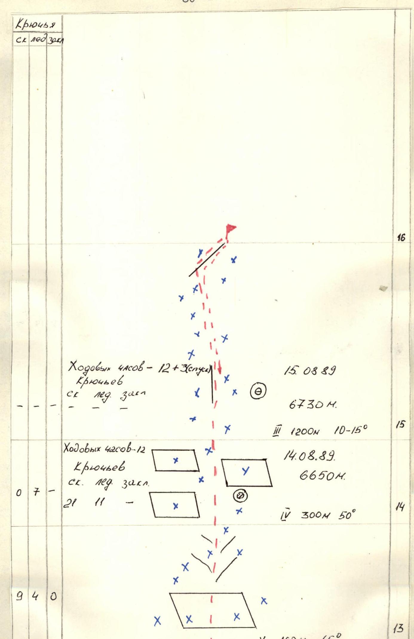
Total: 22.5 kg. Fuel: 5.0 kg. Total weight: 27.5 kg. Route diagram in symbols: M 1:2000
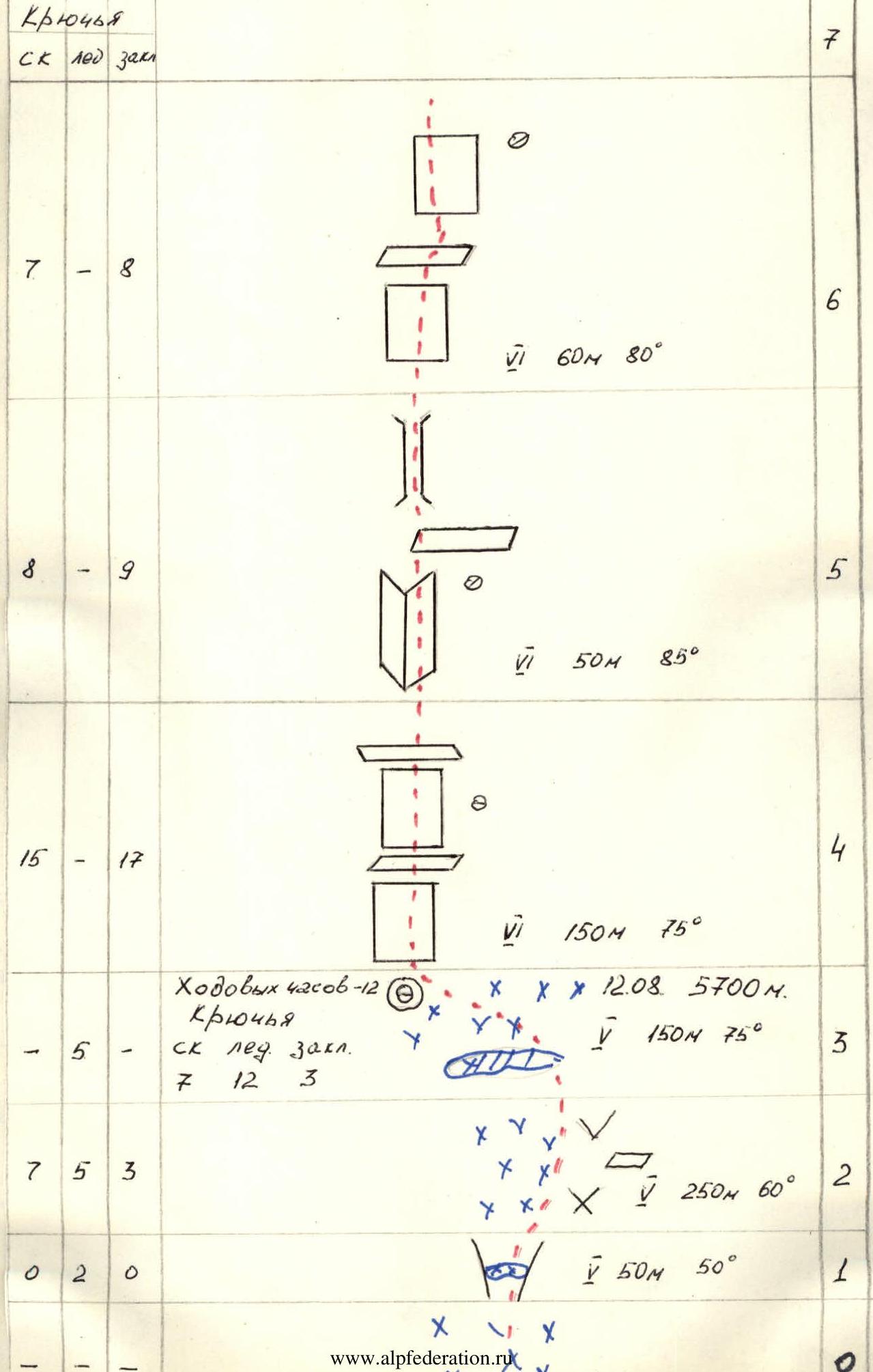
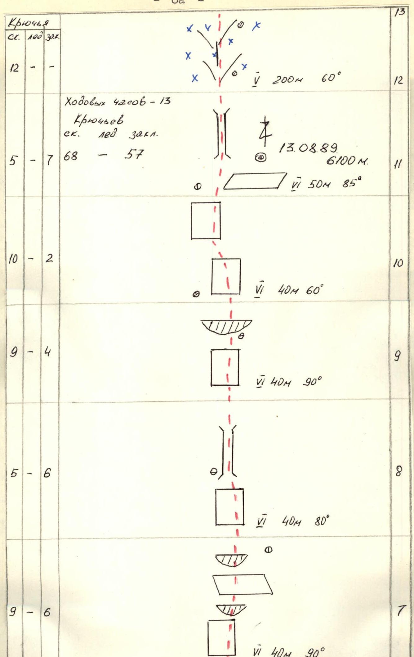
Description of the route by sections
Section R0-R1. Deep, steep snow. In the upper part of the section, there is an ice slope under the snow, and insurance can be provided through ice screws. The bergschrund is traversed via a snow bridge.
Section R1-R2. Deep, steep snow. Insurance through ice axe and ice screws.
Section R2-R3. Deep, steep snow, with ice underneath. Insurance through ice axe and ice screws. It is possible to hammer pitons into rock outcrops.
Section R3-R4. At the start of the section, there is an ice wall. The section is traversed using ice screws. Insurance is provided through ice screws. Further, there is a steep snow slope. Insurance through ice axe.
The entire snow and ice section R0-R4 should be traversed by 14:00, after which the upper part of the wall is exposed to the sun, and spontaneous rockfall is possible.
Section R4-R5. Broken rocks with rock walls alternating with narrow, inclined ledges. Insurance through pitons and placements.
Section R5-R6. Complex wall, 8-9 m high, with large, unreliable holds. In the upper part, movement is through a crack that widens into a chimney, followed by two small walls with narrow ledges. Insurance through pitons; "eccentrics" and "hexes" are effective.
Section R6-R7. Ribbed, broken rock walls alternating with inclined and sloping ledges filled with snow.
Section R7-R8. Overhanging rock section with a crack and two rock cornices. Steepness is 90-95°. Artificial anchors are used. The rocks are highly broken.
Section R8-R9. Rock wall, followed by a 12-meter chimney. The rocks are icy.
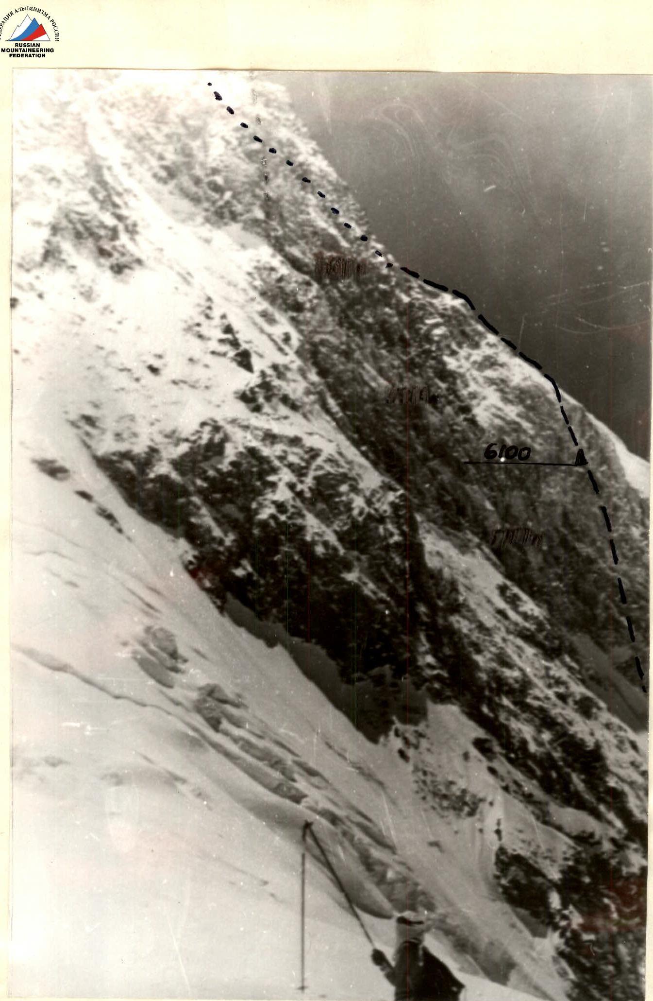
Section R9-R10. Rock wall, cornice. Few cracks for pitons.
Section R10-R11. Monolithic, smooth slabs with few cracks and holds.
Section R11-R12. Internal angle turning into a chimney filled with snow. At the start of the section, a sitting bivouac was organized.
Section R12-R13. Blocky rocks covered with snow.
Section R13-R14. Inclined slabs resembling "sheep's foreheads", covered with snow, with a steepness of 65°.
Section R14-R15. Inclined slabs resembling "sheep's foreheads", covered with snow, with a steepness of 50°. At the end of the section, a semi-reclining bivouac was organized.
Section R15-R16. Broken rocks covered with snow, with a steepness of 50°. Exit to the ridge leading to the summit.
Section R15-R16. Snow and ice ridge with rock outcrops. Crevasses resembling "randkluft". Ascent to the summit. Descent via the same route. At the end of the section, a lying bivouac was organized.
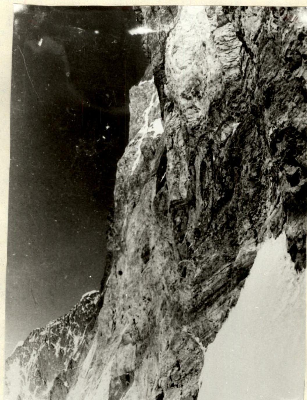
Lower part of the "triangle" rocks.
Technical photo of the route. Taken on August 4, 1989, at 16:00 from point #4, T-40 lens, F = 40 mm. Elevation of the shooting point is 5500 m, distance 2.5 km.
Upper part of the "triangle" on section R8-R12.
Comments
Sign in to leave a comment