Report
on the ascent of Peak Revolyutsii via the right part of the southeastern wall, ice-snow route, (A. Zaydler's route, 1976) category 5B, by the team of the Moscow Aviation Institute (MAI) alpinism club (Moscow), August 21, 2013.
Moscow, 2013 Ascent Passport
- Ascent class: high-altitude
- Ascent area: Pamir, Yagnóblemsky Ridge
- Summit, its height, ascent route: Peak Oktyabr'skoy Revolyutsii, 6940 m, via the right part of the southeastern wall from the Khabarvivkhats Glacier.
- Difficulty category: 5B
- Route characteristics:
Height difference: about 2400 m. Length of sections 5–6 km: 700 meters. Average steepness: 45°
- Number of pitons driven:
Rock — 0, Ice — 90, Bolts — 0
- Number of walking hours: 72 hours
- Number of bivouacs and their characteristics: 9 bivouacs on the route, all on snow and ice
- Team leader: Tsvetov P.N. — 1st category
Team members: Frankevich A.S. — 2nd category, Kaunova N.M. — 1st category
- Team coach: Volkov M.E.
- Departure from base camp: August 14, 2013
Return to base camp: August 23, 2013
Area Overview
Peak Revolyutsii is the fourth highest peak (after Peaks Kommunizma, Lenina, and Korzhenevskoy) in Tajikistan, with a height of 6940 m (according to other maps — 6974 m), located in the central part of the Pamir, in the Yazgulemsky Ridge. The coordinates of the highest point in the WGS-84 coordinate system: 38°30.59′ N 72°21.25′ E.
At the foot of the northern wall of the summit lies the Great Firn Mulda, from which the largest glacier in Eurasia — the Fedchenko Glacier — originates.
At the foot of the southwestern wall, the northeastern branch of the Yazgulemdara Glacier originates, at the foot of the southeastern wall, the Khabarvivkhats Glacier begins, and from the northeastern slopes of the summit, the second largest glacier in the Pamir — the Grum-Grzhimaylo Glacier — flows.
The first ascent of Peak Revolyutsii was made during an expedition by climbers from the All-Union Central Council of Trade Unions (VCSPS) led by E.A. Kazakova. 11 climbers reached the summit under the leadership of A. Ugarov.
Peak Revolyutsii is a nodal peak of the Yazgulemsky Ridge, stretching from west to east. To the north of the summit, a powerful spur extends, which is the watershed between the basins of the Fedchenko and Grum-Grzhimaylo Glaciers. This spur is often referred to as the Vysokaya Stena (High Wall) Ridge. The summits of this spur are often referred to as the "Southern group of Fedchenko". To the south of Peak Revolyutsii, a spur extends, which forms the watershed between the Yazgulemdara and Khabarvivkhats Glaciers.
Approaches to the northern and northwestern walls of the summit are made via the Fedchenko Glacier, which climbers usually reach from the Vanch Valley through the Abdukagor Pass.
Approaches to the northeastern slopes are made:
- from the Tanimasa Valley
- via the Grum-Grzhimaylo Glacier.
Climbers reach the southwestern wall from the Yazgulemdara Glacier, which can be accessed via a trail from the villages of Roshorv and Savnob.
In the moraine pocket of the Yazgulemdara Glacier, at an altitude of 3600 m, a field alpine camp operated for several seasons in the past, with helicopter delivery.
Climbers usually reach the foot of the southeastern wall of Peak Revolyutsii via the Khabarvivkhats Glacier:
- from the Yazgulemdara Glacier through the Revolyutsii South Pass (5702), located between Peak Revolyutsii and the southern peak, Shchypka (6237),
- through the Shchypka Pass (5261), located south of Shchypka Peak.
It is also possible to reach the area via the Khabarvivkhats River valley from the villages of Savnob and Roshorv. The path via the Khabarvivkhats Glacier is complicated by difficult icefalls.
Structure of the summit. Peak Revolyutsii has steep rocky walls falling to the north towards the Fedchenko Glacier, to the southwest towards the Yazgulemdara Glacier, and to the southeast towards the Khabarvivkhats Glacier, and more gentle snow-ice slopes facing northeast towards the Grum-Grzhimaylo Glacier.
The upper part of the mountain is structured like a crater (see Fig. 1), framed by:
- the main summit (6940 m)
- a slightly lower central summit (Peak N. Khrushcheva)
- an even lower southern summit.
At the bottom of the crater, there is a small glacier, which breaks off into an icefall on the southwestern wall of the summit.
The southern and eastern ridges of Peak Revolyutsii converge in the area of the southern summit. The western and northeastern ridges of the mountain converge in the area of the main summit.
At the beginning of the northeastern ridge (outside the crater), the lowest of the four peaks of Peak Revolyutsii — the northern summit — is located.
The shoulder at 6448 m on the eastern ridge of Peak Revolyutsii is called Peak Tumanny, and the shoulder at 6424 m on the northeastern ridge is called Peak Vertikal'ny.
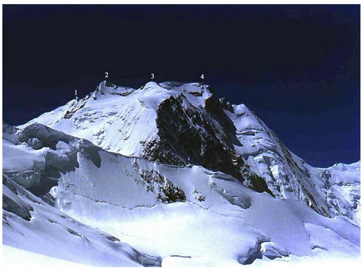
Fig. 1 Peaks of Peak Revolyutsii:
- 1 — Southern
- 2 — Central
- 3 — Northern
- 4 — Main (photo from A.A. Lebedev's report)
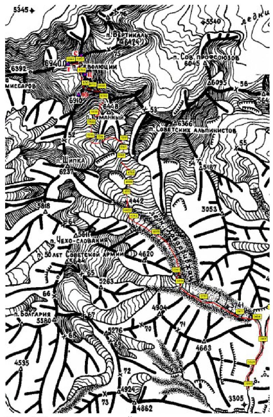
Fig. 2 Map-scheme of the ascent area. Description of the route by sections
| I | Passage through the first stage of the icefall. Wide crevasses. Movement in ropes along the right part of the icefall. Bivouac at the end of the first stage of the icefall. | 500 m 40° III |
|---|---|---|
| II | Passage through the second stage of the icefall. Movement in ropes along the right part of the glacier. Wide crevasses across the entire glacier. Bivouac at the beginning of the third stage of the icefall. | 600 m 50° III |
| III | Passage after the end of the second stage of the icefall to the left part of the glacier. Passage through the third icefall. Wide crevasses. Several ice walls (20–25 m). Simultaneous and alternate movement. | 1000 m 40° III+ |
| IV | Traverse of the slope of Peak Tumanny. Closed glacier. Movement in ropes. Bivouac in the mulda under the Southeastern wall of Peak Revolyutsii. | 300 m 20° II |
| V | Ascent along the right part of the Southeastern wall to the Eastern ridge of Peak Revolyutsii. Movement on ropes. 8 ropes (60 m each). | 400 m 75° V–VI |
| VI | Movement along the sharp ridge to the Southern summit. Cornices towards the Grum-Grzhimaylo Glacier. Several walls (15–20 m). Movement in a rope, simultaneous and alternate. | 300 m 30° IV |
Descent was made via the ascent route.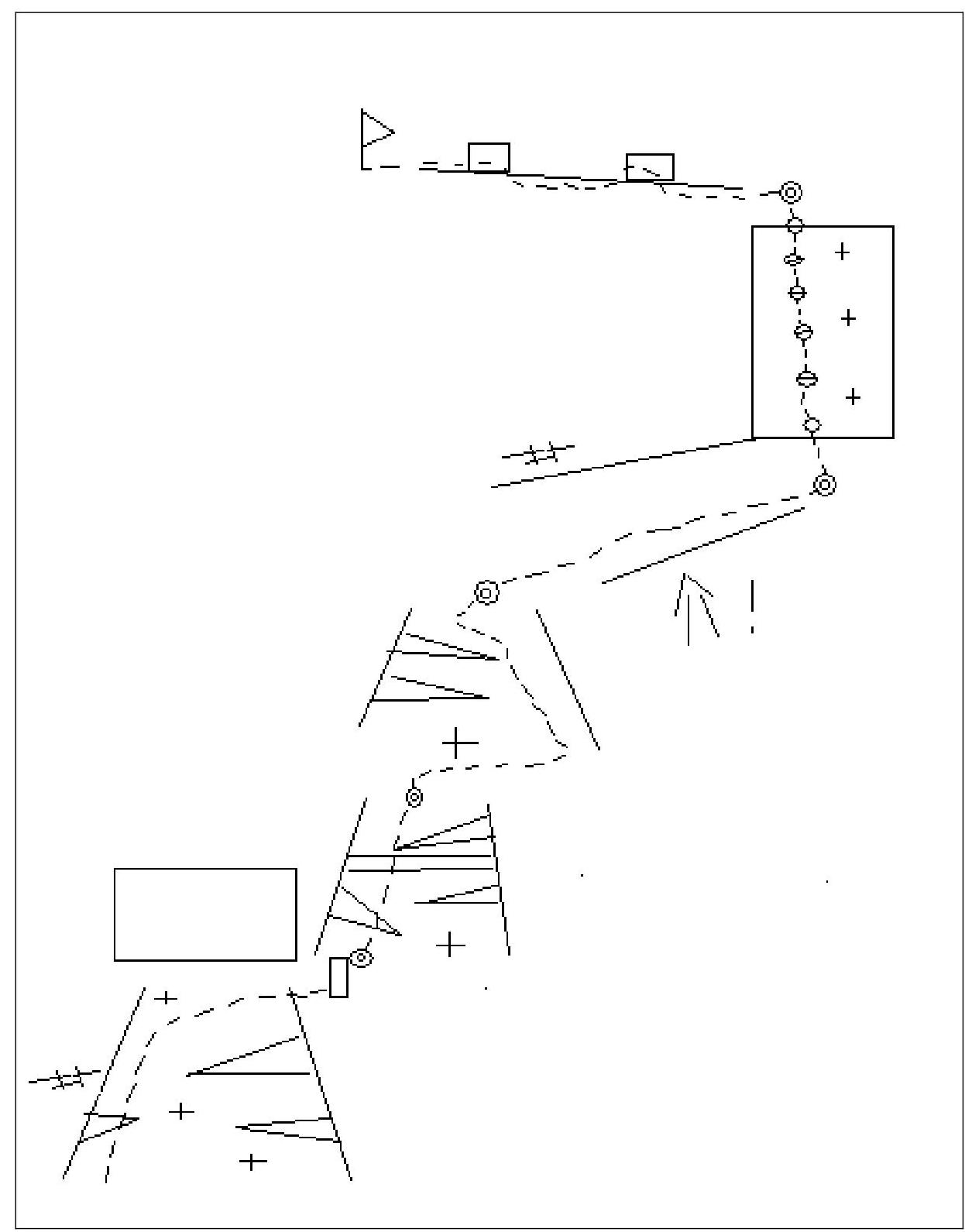
Fig. 3. Scheme of the route in UIAA symbols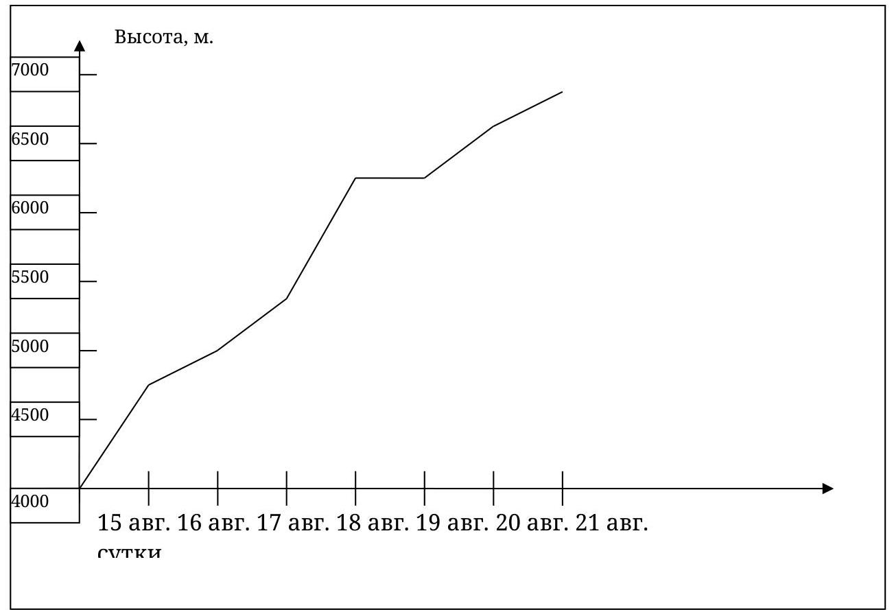
Fig. 4. Ascent height graph
Ascent Description
After arriving in Dushanbe (August 27, 1953), we stocked up on food and gas, found transport, and on August 28, 1953, we set off on the Dushanbe — Khorog highway in 2 cars. We traveled along the highway for about two days, until we reached the mouth of the Bartang River. After turning onto the Bartang road, the good road ended, and a dirt road began. After two days of travel, we unloaded in the village of Roshorv. On the same day, we arranged for "draft animals" — donkeys.
From July 29 to August 12, we were in the Yazgulemdara valley, where we made ascents (to v. Armyentsev, p. Shchypka), actively acclimatizing and conducting reconnaissance for the future ascent. The weather was mostly good.
On August 13. Departure from the village of Savvob along a trail up the Khabarvivkhats River. The trail follows the right (in an orographic sense) bank of the river. We followed the upper trail, which is more convenient.
On August 14. Weather conditions: overcast, rain.
We moved up along the moraine pocket, until it ended. Then we descended onto the glacier. The glacier near the right edge is heavily broken. Moving forward and crossing the right tributary of the Khabarvivkhats Glacier, we found a convenient passage to the right, closer to the axial line of the main glacier. Crevasses are almost absent here.
On the moraines, before the first icefall, at an altitude of 3980 m, we set up a forward base camp.
Weather conditions: variable cloudiness, no precipitation.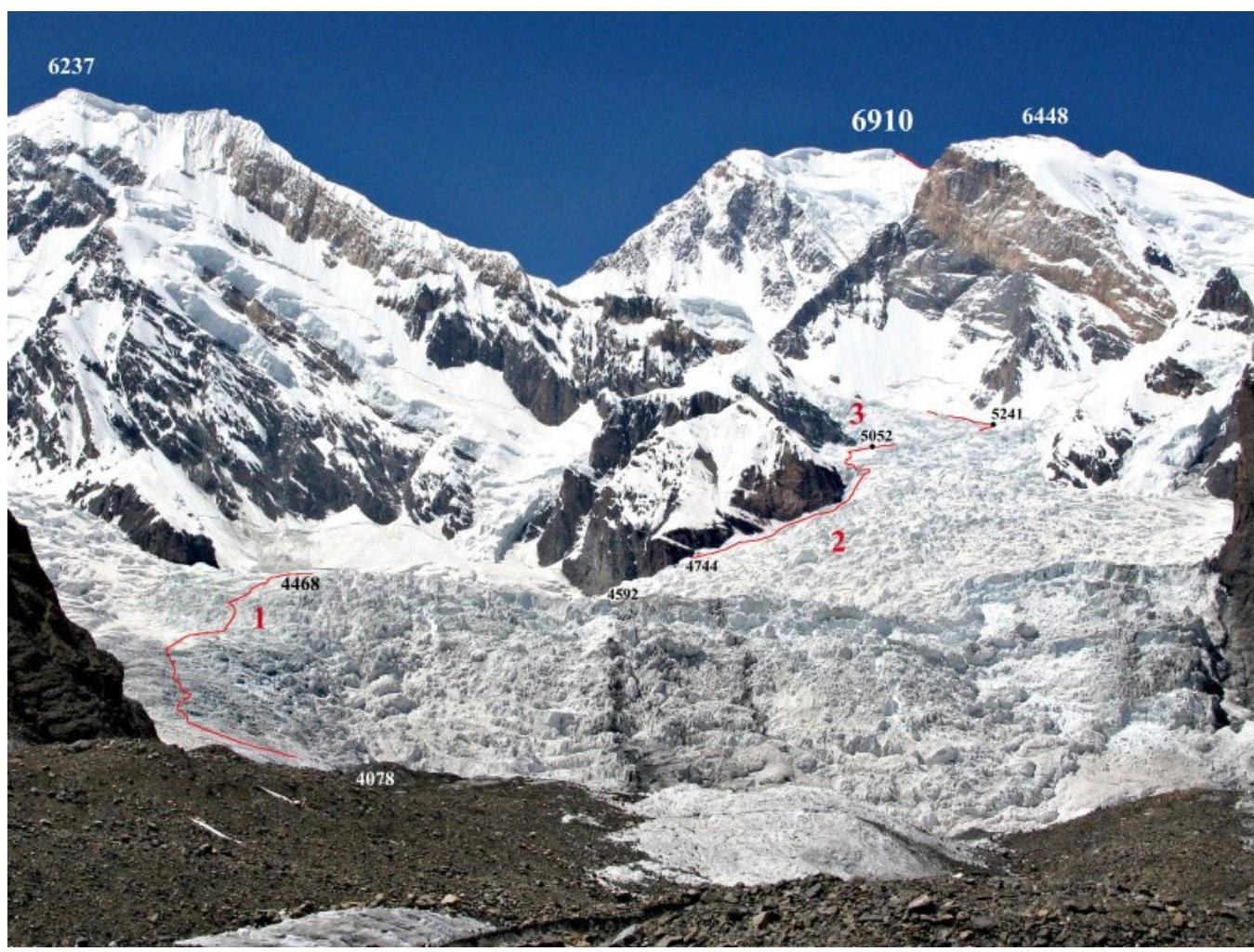
Fig. 5. Photograph of icefalls. 1 — first stage, 2 — second stage, 3 — third stage (photo from A.A. Lebedev's report).
On August 15, we began ascending the first stage of the Khabarvivkhats Glacier icefall. We moved along the right part of the glacier (where there are fewer crevasses), but did not press too close to the edge to avoid ice avalanches from the hanging ice seracs. Movement was in ropes.
On August 16, we started ascending the second stage of the icefall. We moved along its right part, near the rocky walls. The glacier was heavily broken. We crossed crevasses on bridges or jumped over them.
On August 17, we passed the upper part of the second stage of the icefall. We moved close to the right edge of the glacier. We then began ascending the third stage of the icefall.
On August 18, we transitioned into the cirque of Peak Tumanny. We moved simultaneously in ropes, with few crevasses, but they were covered. We then traversed the slope of Peak Tumanny, avoiding the formation of snowboards.
On August 19, 1953, the weather worsened. We were stuck in our tent, waiting for the bad weather to pass.
On August 20, 1953, the weather was not good, but there was no snow. We began ascending to the eastern ridge of Peak Revolyutsii. We chose a route along the ice slope, as it was considered less objectively dangerous than the rocky outcrop used by the first ascenders.
On August 21, 1953, we made a storming ascent. We started at 6:30 AM, moving lightly. It was very cold, with gusty winds. We passed the "knife" — a ridge with a cornice on the northern side and 45° firn on the southern side. We then moved along the widening ridge, with some closed crevasses.
Due to bad weather, we decided to ascend only to the Southern summit of Peak R Revolyutsii.
After reaching the summit, we began descending to the camp. Visibility was zero, and our tracks were covered by snow.
On August 22–23, we descended from the summit via the ascent route. The descent was complicated by bad weather — wind, cloudiness, and snow.
Tactical Actions of the Team
Upon arrival in the area, the team made several acclimatization ascents in the Yazgulemdara valley (to v. Armyentsev, p. Shchypka). During these ascents, the team conducted reconnaissance of the route and approaches to the ascent area.
The team showed high organization, strong sportsmanship, and moral-volitional preparation during the ascent. All team members conducted preparatory training, which yielded positive results during the ascent.
The team was equipped with satellite communication throughout the ascent. One team member had a medical education.
The team did not experience a shortage of equipment, food, or gas, ensuring the safety and reliability of the ascent.
Another team of climbers from the MAI alpinism club was present in the area, ensuring additional safety.
Results and Recommendations
Considering the inaccessibility and remoteness of the area, in the event of an emergency or illness of one of the team members, it is necessary to rely only on one's own strength and be prepared for a prolonged exit from the area.
It is recommended to plan the ascent for an earlier time, presumably July, due to the unsatisfactory state of the icefall (broken glacier, absence of snow bridges, crevasses across the entire glacier).
In conditions of bad weather and limited visibility, it is strongly recommended to use a GPS navigator with pre-loaded route points.
In conclusion, this route is an excellent opportunity to ascend a seven-thousander via a "non-classical" route.