1. Ascent Passport
- Region: Yazglem Ridge (Central Pamir). Valley: Fedchenko Glacier Section number according to the 1999 classification table – 4.12
- Peak name: Pik Revolyutsii. Route name: via the rib on the eastern edge of the northern wall.
- Proposed – 5B category of complexity, first ascent.
- Route type: combined
- Route elevation gain: 1524 m (by altimeter) Route length: 3355 m. Length of section: V category of complexity – 0 m, VI category of complexity – 0 m. Average steepness:
- main part of the route – 45.8°
- entire route – 27.5°
- Pitons left on the route: Total – 0; including, bolted – 0 Pitons used on the route: Ice screws – 35, rock pitons – 4 Stationary bolted pitons – 0, including, TTO – 0 Removable bolted pitons – 0, including, TTO – 0 Total TTO used – 0 For bivouac organization on the rib (from August 7 to August 8) – 6 ice screws
- Team's travel time: 24 h 20 min, 4 days
- Team leader: Lebedev Andrey Alexandrovich Team members:
- Maslennikov Alexey Vasilievich
- Osokin Vasily Viktorovich
- Popov Vadim Anatolievich
- Coach: Lebedev Andrey Alexandrovich
- Route start: 12:30 August 6, 1990. Reached the summit: 12:15 August 9, 1990. Descended to Grumm-Grжимайло Glacier: 15:10 August 10, 1990.
From the report on the mountaineering trip to 4. Pamir, ranked – I place at the 1990 USSR Championship.
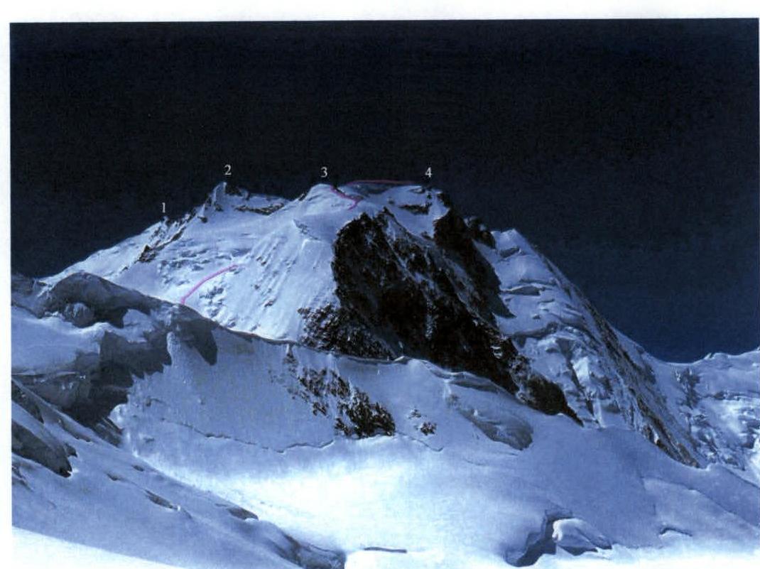 Fig.1. Pik Revolyutsii from the north-northeast. Taken on August 5, 1999, from the western slope of Omar Khayyam Pass. Summits of Pik Revolyutsii:
- 1 – South
- 2 – Central
- 3 – North
- 4 – Main
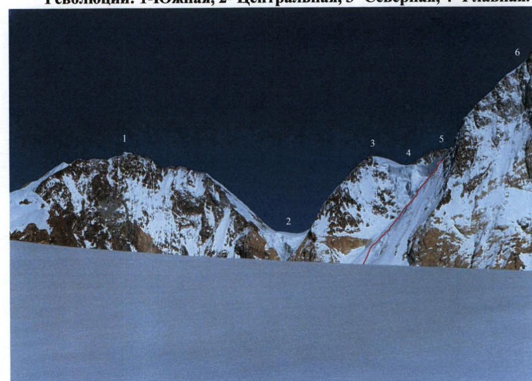 Fig.2. View from Fedchenko Glacier to the eastern and southeastern surroundings of the Large Firn Mulde. Taken on August 4, 1999, from the base of the southwestern rib of Pik Gidroстроителей.
- 1 – Pik Gрина (6502 m)
- 2 – icefall from the plateau of Vertikal Pass
- 3 – peak 6350 m
- 4 – icefall from the plateau of Revolyutsii Pass (behind the icefall, the depression of Revolyutsii Pass is visible)
- 5 – northwestern ridge of Pik Vertikal (6424 m)
- 6 – northeastern ridge of North summit of Pik Revolyutsii
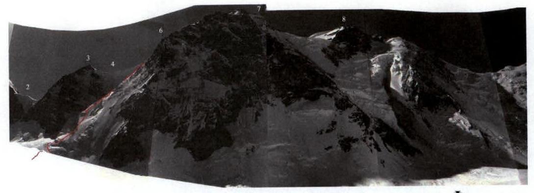 Fig.3. View of Pik Revolyutsii from the northwest from Fedchenko Glacier. Taken on August 6, 1990.
- 2 – icefall from the plateau of Vertikal Pass
- 3 – peak 6350 m
- 4 – icefall from the plateau of Revolyutsii Pass
- 6 – northeastern ridge of North summit of Pik Revolyutsii
- 7 – North summit
- 8 – Main summit
3. Overview of the Region
Pik Revolyutsii (6974 m) is located in the Yazglem Ridge at its junction with the northern spur, which separates Fedchenko and Grumm-Grжимайло Glaciers. Therefore, the northwestern and northern slopes of the peak descend to Fedchenko Glacier, and the northeastern ones – to Grumm-Grжимайло Glacier. The upper reaches of Fedchenko Glacier can be reached from the Vanch valley through Abdukagor Pass. The upper reaches of Grumm-Grжимайло Glacier can be reached either from Vítkovského Glacier through Zimovshchikov Pass or directly from Fedchenko Glacier via the combination of Omar-Khayyam and Yubileinyi Passes. From the south, from Savnob, to Grumm-Grжимайло Glacier, it is easiest to pass through Bartang or Kamenny Tsvetok Passes. It is also possible to make a long ascent along Grumm-Grжимайло Glacier from the Tanymas River valley.
 On the diagram:
- 23 – Abdukagor Pass
- 78 – Omar Khayyam Pass
- 79 – Yubileinyi Pass
- 80 – Zimovshchikov Pass
- 57 – Bartang Pass
- 58 – Kamenny Tsvetok Pass
- 76 – Vertikal Pass
- 75 – Ugarov Saddle
- 22 – Revolyutsii Pass
- 54 – Zheleznodorozhnik Pass
- 55 – Optimalnyi Pass
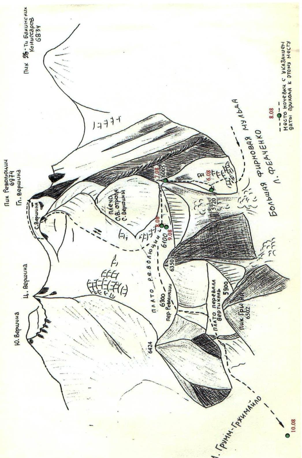 Diag.1. Structure of the northeastern slope of Pik Revolyutsii, Revolyutsii and Vertikal Passes
 Diag.2. Schematic map of the northeastern slope of Pik Revolyutsii, Revolyutsii and Vertikal Passes
6. Technical Photographs of the Route
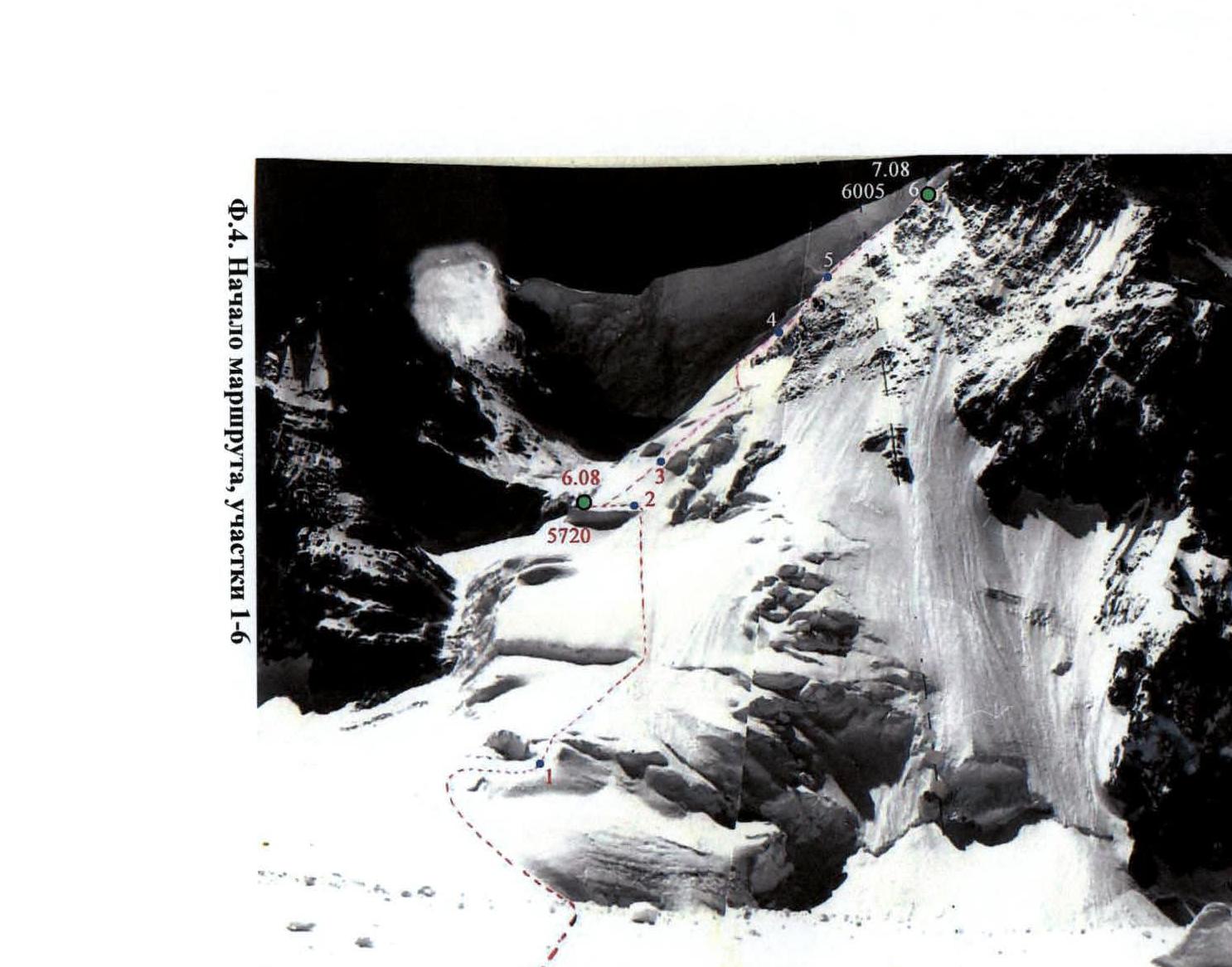 Fig.4. Beginning of the route, sections 1–6
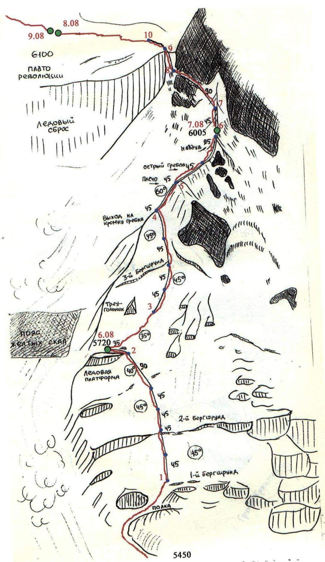
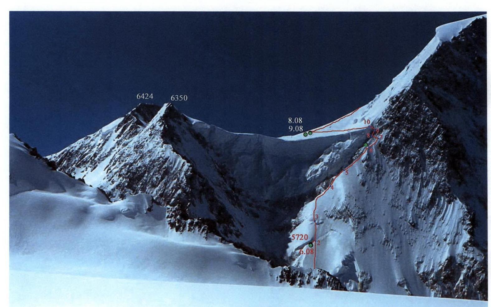 Fig.5. Taken on August 5, 1999, from the western slope of Omar Khayyam Pass. Sections 3–10. The ice situation on the rib has practically not changed over 9 years.

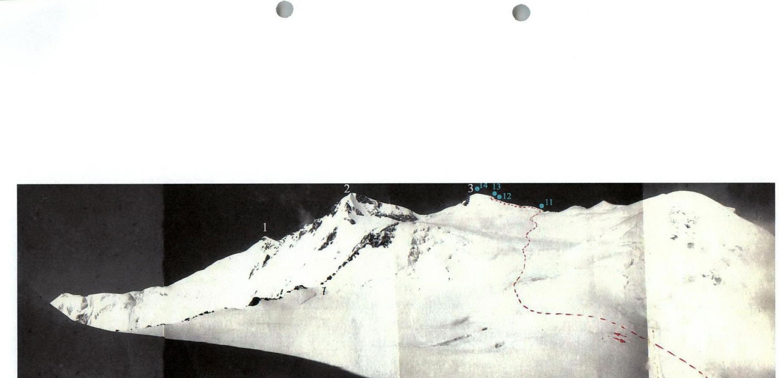 Fig.6. View from the plateau of Revolyutsii Pass. Sections 11–14. Summits of Pik Revolyutsii:
- 1 – South
- 2 – Central
- 3 – North
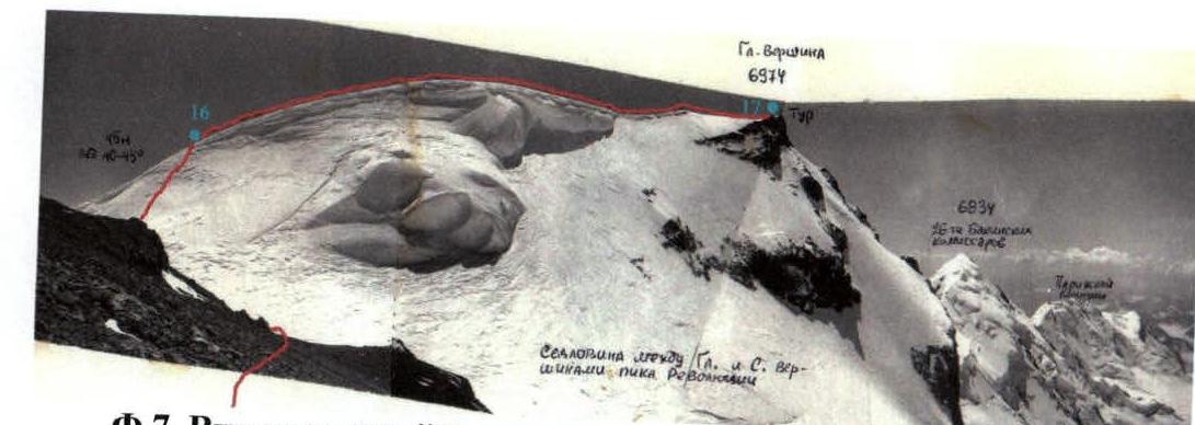 Fig.7. View from the North summit to the Main summit. Sections 16 and 17.
7. Route Sections Table
| № | Section Name | Start Height | End Height | Photo | Difficulty | Length (m) | Steepness (°) |
|---|---|---|---|---|---|---|---|
| 17 | Snow ridge : | 6932 | 6974 | 7 | 1 | 250 | 0–15 |
| 16 | Ice slope : | 6900 | 6932 | 7 | 3 | 45 | 45 |
| 15 | Talus slope : | 6920 | 6900 | – | 0 | 80 | 15 |
| 14 | Snow slope of North summit dome : | 6911 | 6920 | 6 | 1 | 40 | 15 |
| 13 | Snow-ice wall : | 6900 | 6911 | 6 | 3 | 15 | 45–50 |
| 12 | Snow ridge : | 6865 | 6900 | 6 | 1 | 100 | 20 |
| 11 | Snow slope : | 6100 | 6865 | 6 | 1 | 1800 | 20–25, occasionally up to 35 |
| 10 | Snow slope : | 6087 | 6100 | 5 | 2 | 20 | 40 |
| 9 | Ice couloir (randevoux) : | 6074 | 6087 | 5 | 3 | 20 | 45, in the upper part 35° |
| 8 | Inclined traverse across the wall. Rock, ice glazing | 6030 | 6074 | 5,9,11 | 3 | 90 | From 45° to 55° on rocks |
| 7 | Snow-ice ridge : | 6005 | 6030 | 5 | 2 | 45 | 35 |
| 6 | Sharp snow-ice ridge : | 5954 | 6005 | 4,5 | 4 | 70 | 40, in the upper part rise to 50° |
| 5 | Ice slope : | 5915 | 5954 | 4,5 | 4 | 45 | 60 |
| 4 | Snow-ice slope : | 5788 | 5915 | 4,5 | 3 | 180 | 45 |
| 3 | Snow slope : | 5720 | 5788 | 4,5,8 | 2 | 100 | 35 |
| 2 | Snow-ice slope : | 5528 | 5720 | 4,5 | 3 | 270 | 45 |
| 1 | Snow-ice slope : | 5450 | 5528 | 4 | 2 | 185 | 20–25 |
 The diagram marks the ends of corresponding sections along the route with red numbers.
10. Description of the Route Passage
(Edited excerpts from the tourist trip report)
10.1. Stage 1. Ascent to Revolyutsii Pass Plateau
Revolyutsii Pass is located in the northeastern shoulder of Pik Revolyutsii, connecting the Large Firn Mulde of Fedchenko Glacier with Grumm-Grжимайло Glacier. The defining side is the western one. For the first time, it was ascended from east to west in 1978 by a group of tourists led by Nikolai Volkov. From west to east, the pass was first traversed by our group.
Between the icefall from the plateau of Revolyutsii Pass and the northern wall of Pik Revolyutsii, there is an ice ridge that abuts against the rock wall slightly below the plateau level, see Fig.4 and Fig.5. Between the ridge and the icefall from the plateau, a couloir descends, carrying ice debris. The ridge is not accessible to ice debris and represents a logical and safe path from Fedchenko Glacier to the plateau of Revolyutsii Pass. The height of the Large Firn Mulde is 5450 m. The height of the plateau is 6100 m.
Almost throughout the entire ascent, belays are required. The key section is the transition from the ridge to the plateau by traversing icy rocks, located at a height of 6050 m. It takes 2–3 days to ascend to the plateau and 3–4 days to fully traverse the pass from west to east.
August 6. Clear morning. We reached the beginning of the route at 10:45. During lunch, we studied the ascent path through binoculars and marked possible overnight locations. We started the ascent at 12:30.
Section 1. After passing through the zone of ice debris, we approached the right (in the direction of travel) edge of the avalanche cone and climbed up to the icefall – a continuation of the wide lower bergschrund, see Fig.4.
Section 2. The aforementioned icefall blocks the pocket from direct hits of ice debris from the couloir. Under the icefall, there is a ledge, in the right (in the direction of travel) part of which the bergschrund has a bridge. From here, the ascent is straight up (100 m, 45°, firn, belays) to the second bergschrund, which is easily overcome via a snow bridge. Above the second bergschrund, the ascent continues upwards and slightly left (in the direction of travel) to an ice platform (40–45°, firn, 180 m of belays). On the edge of the ice platform closer to the couloir, there were convenient places for tents (35 m of belays traversing the slope). For orientation: the ice platform is located just below the base of the belt of yellow rocks in the couloir. Collective belay on the overnight stay was not required. Height 5720 m.
August 7, 1990. Clear morning. Departure at 8:00.
Section 3. Above the ice platform, the slope becomes gentler, reaching 35°. Steps were formed easily, and we covered the next 100 m to the triangular icefall, see Fig.4 and Fig.8, simultaneously.
Section 4. Above the triangle, the slope becomes steeper (45°, first firn, then shallow snow on ice). To the third bergschrund, connecting the edge of the ridge with the belt of rocks, we hung 90 m of belays. The bergschrund is easily overcome via a snow bridge. Above the bergschrund, 90 m of belays (45°, firn) lead upwards and left (in the direction of travel) to the edge of the ridge.
Section 5. Along the edge of the ridge, which becomes sharp here (small cornices on the side of the couloir), 45 m of belays on a steep slope (60°, ice with firn crust) lead to a shoulder.
Section 6. Above the shoulder, the ridge becomes gentler, reaching 40°, but remains sharp. On the turn of the ridge to the left (in the direction of travel), there is a small overhang (8 m, 50°). From the shoulder to the top of the overhang, there are 70 m of belays. We moved along the right (outer from the couloir) side of the ridge. This was the only avalanche-prone section throughout the ascent (ice slab). On the left side of the ridge, there are cornices and very steep.
Section 7. Behind the overhang, the ridge has a steepness of 30–35°. For 40 m, it remains sharp and then transitions into an ice slope (30 m), abutting against a rock wall.
After two unsuccessful attempts, we finally found two places where the snow on the sharp ridge was deep enough to dig out half of the tent floor with shovels. We managed to carve out another quarter of the area in the ice with ice axes. We were unable to fully clear the space for the tents. We slept in two tents with 4 people in quite uncomfortable positions. All actions on the bivouac, including sleep, were performed using collective belays organized on ice screws. Height 6005 m.
August 8, 1990. Clear morning. Due to the significant cramped conditions on the narrow ridge and the need to constantly belay, the group started working only at 11:30.
After ascending the ridge to the rocks (45 m of belays), we realized that further processing of the route with backpacks was impossible.
Section 8. We had to wait for the leading team to process the key section. The main difficulty on this section is steep icy rocks (crampons held uncertainly, with feet constantly alternating between rocks and ice glazing). The traverse across these rocks (70 m) leads to a randevoux. On the traverse, 3 channel pitons were hammered, 1 petal, and 2 loops were hung.
Section 9. In the randevoux, the ascent becomes easier (first 45°, then 35°, ice, 20 m of belays).
Section 10. From the randevoux, the ascent continues left (in the direction of travel) with an exit to the plateau (40°, snow, 20 m of belays). On the plateau (6100 m), there is a bivouac.
10.2. Structure of the Summit Above Revolyutsii Pass Plateau
Revolyutsii Pass Plateau (6100 m) is located on the northeastern slope of Pik Revolyutsii and feeds Fedchenko Glacier through an icefall above the rib of Revolyutsii Pass. The actual Revolyutsii Pass (as a watershed between Fedchenko and Grumm-Grжимайло Glaciers) is located in the northeastern part of the plateau between peak 6350 m, limiting the aforementioned icefall from the northeast, and Pik Vertikal (6424 m) in the northeastern spur of the Central summit of Pik Revolyutsii. The northeastern spur of the Central summit limits the plateau of Revolyutsii Pass from the southeast. It was via this spur that the group of first ascenders led by A. Ugarov ascended to the plateau of Revolyutsii Pass in 1954. From the slope between the Central and Main summits of Pik Revolyutsii, a glacier descends onto the plateau. The right side of this glacier is formed by the northeastern spur of the Central summit, and the left side – by the northeastern spur (ridge) of the North summit. Between the North and Main summits (50 m below the North summit), there is a saddle, from which a steep glacier descends to Fedchenko Glacier.
10.3. Stage 3. Ascent to Pik Revolyutsii
After rounding the shoulder of the northeastern spur of the North summit, we ascended to the northeastern ridge of the North summit and along it (100 m) reached the North summit, then traversed to the Main summit of Pik Revolyutsii. During the ascent to the rise of the North summit, we hung 15 m of belays, and during the ascent from the saddle between the North and Main summits to the southeastern ridge of the Main summit, we hung 45 m of belays (ice, 40–45°). The rest of the path is traversed simultaneously across gentle snow slopes or wide ridges.
August 9, 1990. We rose at 3:30. Prepared and had breakfast under the Moon. Departed at 5:15. Reached the Main summit of Pik Revolyutsii at 12:15. Descended from 14:00 to 16:20.
10.4. Descent to Grumm-Grжимайло Glacier
August 10, 1990. The weather deteriorated. Clouds rushed across the sky, driven by a strong westerly wind. When the next cloud hit us, visibility disappeared, and a snowstorm began. We departed at 8:30. Ascended to the saddle (6300 m) (watershed on Revolyutsii Pass) across a gentle snow slope (~15°) for 40 minutes. We did not find a tour on the pass, but on the rocks of the ridge of Pik Vertikal (6424 m), we found a new loop made of a rope (someone had recently descended here). From the saddle of the pass, cornices hung down towards the North. After destroying a cornice in the narrowest place:
- We hung 90 m of belays, securing them to a nylon "parachute" – a snow anchor.
- Descended along these belays (45°, ice under 30 cm of snow).
- Drilled a prouhoon and hung another 90 m of belays.
Further, the slope becomes gentler and transitions into the plateau of Vertikal Pass. The bergschrund under the slope was densely filled with snow.
We began descending from the plateau of Vertikal Pass at the left edge of the ice couloir, located on the right edge of the plateau and bordered (on the right side) by the rocks of Pik Vertikal (6424 m). On a prouhoon, we hung 40 m of belays to the exit to the rocks (ice, average steepness 45–50°, partially sheer). From the rock ledge, we descended (90 m, ice, 45°, prouhoon) downwards and to the right, crossing the couloir to the exit to the rocks and to the talus under them. From the talus, we descended straight down to the saddle in the bergschrund (90 m, ice, 35°, prouhoon). Below the bergschrund, the slope becomes gentler and transitions into the plateau of Grumm-Grжимайло Glacier.
11. Photo Illustrations
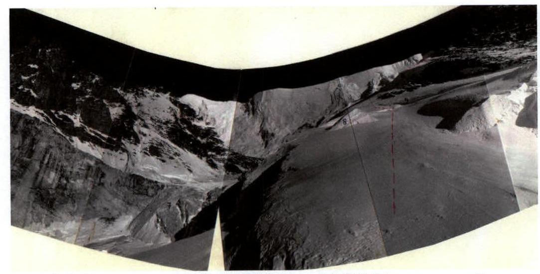 Fig.8. View from the overnight stay site from August 6 to August 7 (5720 m) on section 3. On the left – the gully of ice debris discharge.
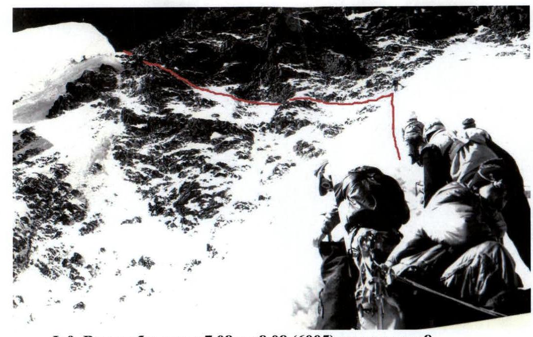 Fig.9. View from the bivouac site from August 7 to August 8 (6005 m) on section 8.
 Fig.10. Bivouac (6005 m), morning of August 8. An icefall is descending along the gully.
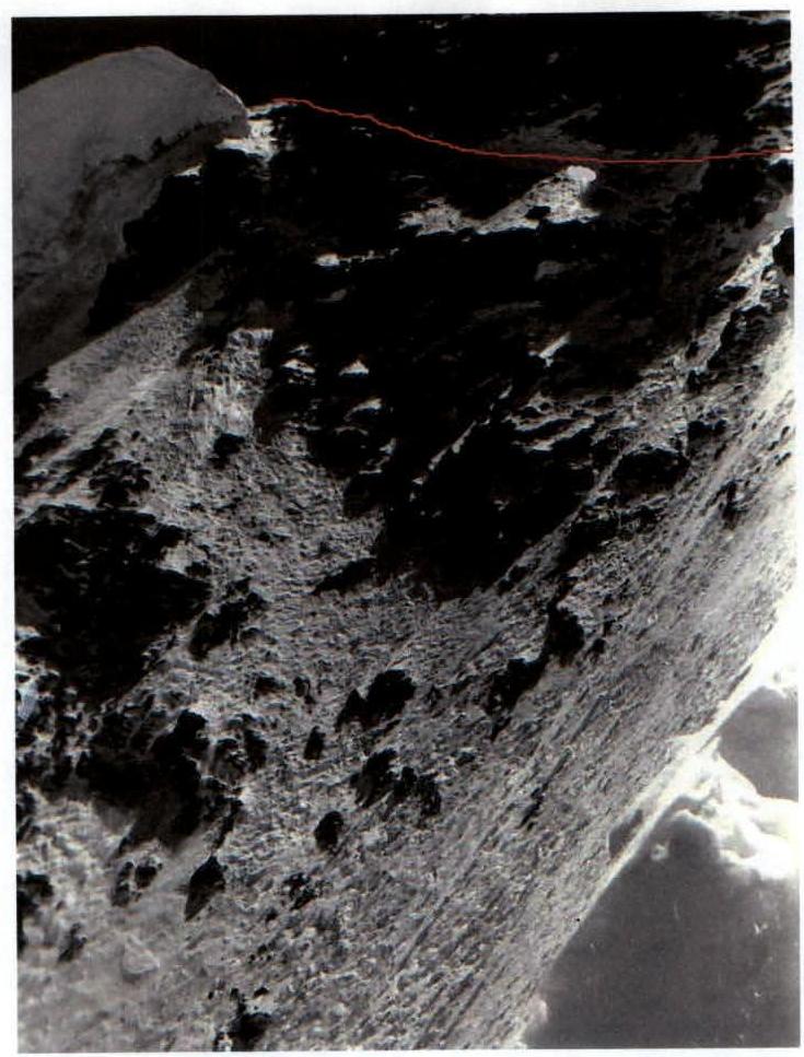 Fig.11. Section 8.
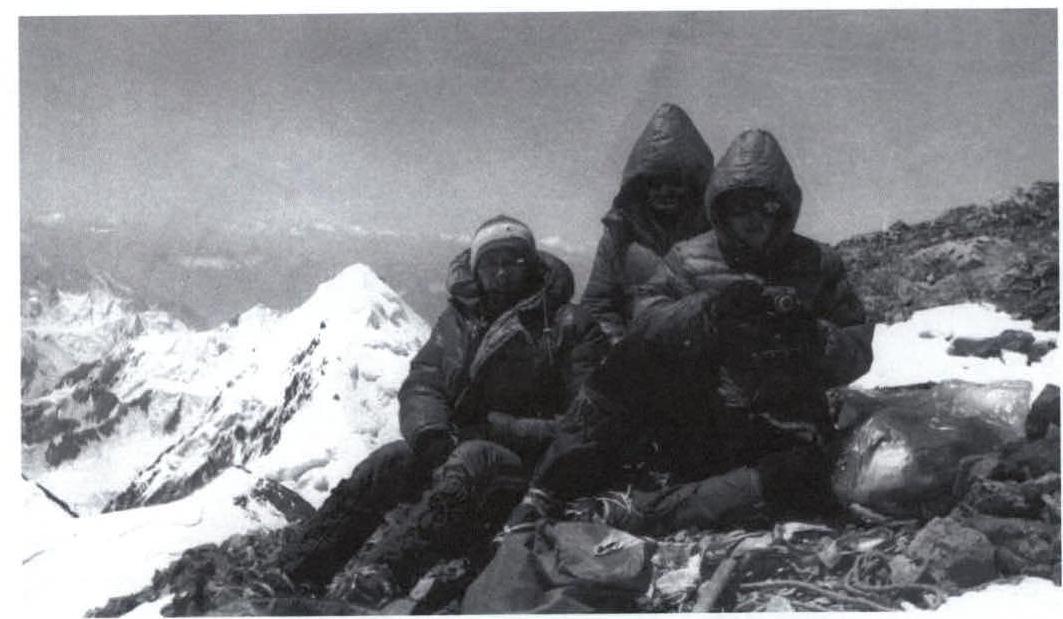 Fig.12. On the Main summit. To the left – Pik 26-ti Baku Commissars.