Central Pamir. Peak 5662 (50 years of the USSR Armed Forces) via the north ridge
MOS DSO "Zenit" Team
consisting of:
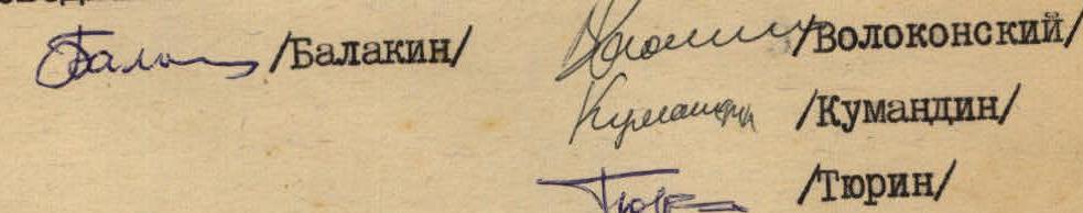
- Balakin A.V. — 2nd sports category — leader
- Volokonsky V.V. — 2nd sports category — member
- Kumandin A.G. — 2nd sports category — member
- Tyurin G.S. — 2nd sports category — member.
Senior coach, Master of Sports of the USSR — P.I. Povarnin.
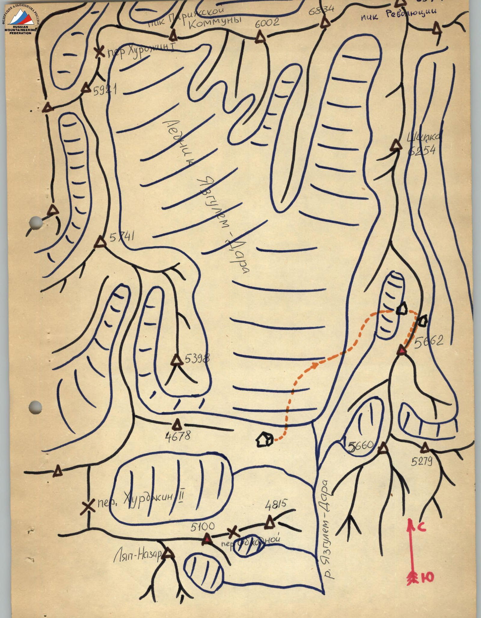
Geographical Location
The gathering place for MOS DSO "Zenit" climbers in 1970 was the area of Peak Revolyutsii with the base camp located in the upper reaches of the Yazgulem-Dara valley.
The summit — Peak 5662 (50 years of the USSR Armed Forces), which the team aimed to ascend, belongs to the mountain range stretching south from the highest peak in the area — Peak Revolyutsii (6974 m), and is located south of Peak Shipka (6254 m).
The region is dominated by six-thousander peaks located in the northern part of the valley: Peaks Revolyutsii, 26 Baku Commissars, and Paris Commune. The Yazgulem-Dara glacier originates from the southern slopes of these peaks, while one of the world's largest glaciers, the Fedchenko Glacier, originates from the northern slopes.
Climatic conditions in this region are relatively favorable. During the summer months — July and August — fairly stable clear weather is observed. At altitudes around 6000 m, the wind almost never subsides, reaching 10–15 m/s, and the temperature drops to −20 °C at night.
The remoteness (over 100 km) from populated areas and roads significantly complicates the organization of expeditions to this region. The use of a helicopter to transport cargo and people to the base camp from the village of Rushan saved us a lot of time.
Organization of the Ascent
Considering the route's features — the presence of snow-ice and rocky ridge and wall sections, the group was equipped with:
| Main rope | 2 × 40 m |
|---|---|
| Auxiliary rope | 9 × 40 m |
| Rock hammer | 2 pcs. |
| Rock pitons | 20 pcs. |
| Ice pitons | 8 pcs. |
| Carabiners | 20 pcs. |
| "Pamirka" tent | 1 pc. |
|---|---|
| "Shmel" primus | 1 pc. |
| Petrol | 2 liters |
| Radio | 1 pc. |
| Signal flares | 3 pcs. |
| First-aid kit | 1 set |
All team members had crampons and down equipment. The amount of food was calculated at 750 g of dry rations per person per day for the 3-day ascent.
For communication with the base camp and the interaction group that ascended Peak Shipka via the southwest edge (led by Kuzmina S.), a portable radio was taken, and communication times were set: 9:00 and 17:00; emergency communication — 12:00 and 21:00. Additionally, communication using signal flares was planned.
Route Progression
Day 1. July 27th. The group departed from base camp "3700", crossed the Yazgulem-Dara glacier in its lower part, ascended to the left-bank (orographic) moraine, and continued moving along the steep grassy slope and scree towards Peak Shipka. Upon reaching the plateau, the movement continued along its left side through the old moraine under the walls of the southern ridge of Peak Shipka. At 17:00, having reached the glacier flowing from the saddle between Peaks Shipka and 5662, the group stopped for the night.
Visual observation of the further route revealed that a steep snow-ice couloir leads to the saddle, narrowing at the top and then branching out. In this area, ice is visible. In the lower part of the couloir, there are avalanche deposits, and on the snow-covered sections, signs of rockfall are noticeable.
Day 2. July 28th. The group started the route at 4:00, carrying a tent. The ascent up the couloir was done directly on crampons with careful observation of the gullies to the right — from Peak 5662. The movement began in rope teams:
- Balakin — Volokonsky
- Tyurin — Kumandin
In the lower part:
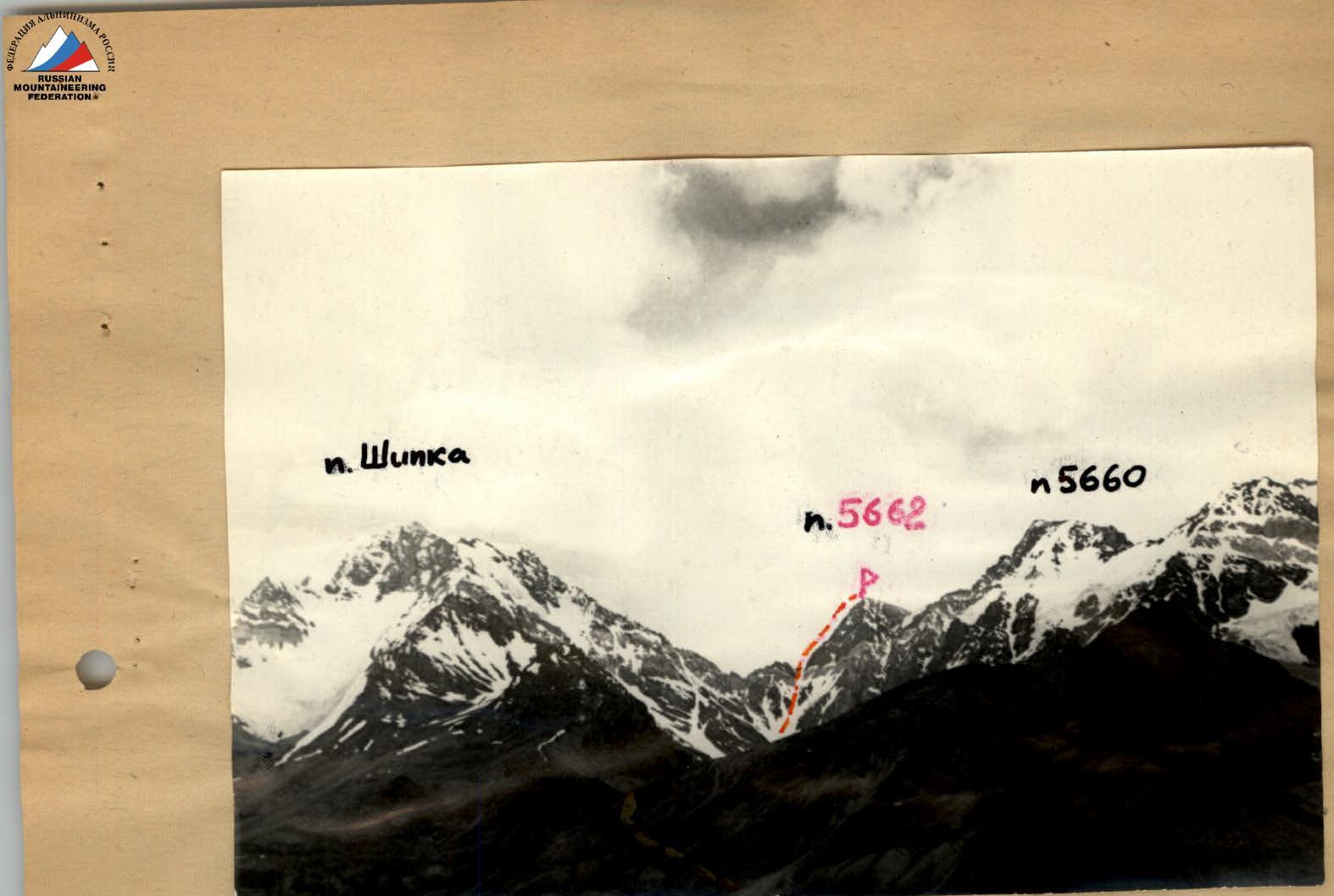
On the way to Peak 5662 (part of the R0–R1 section)

General view of the route to Peak 5662
In the lower part of the couloir (20°, 300 m) — simultaneous movement (section R1–R2). As the steepness increases (30°, 250 m) — movement on crampons with alternate belay via ice axe (section R2–R3). The upper part of the couloir (section R3–R4) is very steep (up to 40°), with exposed ice in places, and is traversed with belay via ice pitons (4 pitons). The saddle is reached via the right branch of the couloir, leaving a gendarme on the saddle to the left. There is a good bivouac site on the saddle (section R4–R5).
From the saddle, the route proceeds onto the rocks of the destroyed ridge (leftward) — rocks of medium difficulty (50–60°, 150 m), with belay via outcrops and pitons (4 pitons). Further, a short snowpatch leads to a 15-meter wall (section R6–R7). The wall is climbed directly. Climbing is challenging (70–80°). In the lower part of the wall, there is some ice. Belay is via pitons (4 pitons). Then, along a poorly defined ridge (40–50°, 6 ropes), section R7–R8, directly upwards to the second wall. Climbing is of medium difficulty. Movement is alternate. Belay is via outcrops and pitons (6 pitons). The second wall (60–70°, 30 m), section R8–R9, is climbed on the left side. Climbing is challenging. Many "loose" rocks. The rocks have a slab-like structure. Belay is via pitons (8 pitons). This section can be bypassed to the left — via a narrow snow "tie" followed by an ascent up a 6-meter slab covered in ice. The path taken by the team is preferable.
Further, 4 ropes along the destroyed ridge with a steepness of 40–50°; movement is simultaneous.
The summit is reached via a steep snow dome (50–60°, 80–100 m). Movement is alternate, with belay via ice axe.
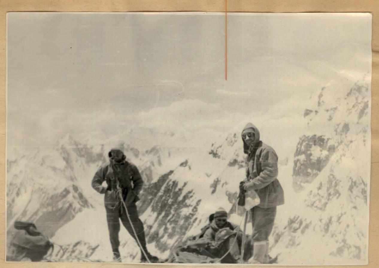
The group reached the summit by 14:00. A note from the CS DSO "Zenit" team was found.
The descent followed the ascent route down to a large rock on the upper platform of the 2nd wall. From here, a rappel descent was made to the right (in the direction of descent) down a steep snow-ice slope to a rocky outcrop, followed by rope retrieval. On the rocky outcrop, a controlled descent was organized onto a steep snow slope, leading to a platform on the saddle. Movement on this section was alternate with belay via ice axe.
Having reached the saddle by 18:00 and considering the danger of further descent via the couloir (avalanches, rockfall), the group stopped for the night. Day 3. July 29th. The group began the descent from the saddle via the couloir at 7:00 and returned to base camp "3700" around 14:00.
The main part of the ascent took 17 hours.
Evaluation of the Participants' Actions
All participants demonstrated good technical, moral-volitional, and physical preparation. The cohesive team composition allowed for a balanced and rational distribution of participants' efforts along the route. Both rope teams alternated positions during the ascent, maintaining a high pace. The successful ascent of Peak 5662 was also facilitated by the team's sense of collectivism and camaraderie.
Route Evaluation
The route is similar in character to the combined route to V. Doppakh Center. peak (via the western ridge) of 4B category difficulty or, in terms of the rocky section, comparable to the route to Peak MNR Center. peak (via the northwest wall) of 4B category difficulty.
However, the route taken is complicated by the presence of steep snow-ice sections in the upper part of the couloir, has greater length, and absolute height. Overall, the group considers the route to be of 4B category difficulty.
Conclusion
The ascent of Peak 5662 via the north ridge represents a combined rock-snow-ice route.
The total ascent is 1960 m. On the main section — 1070 m with an average steepness of 42°. The route corresponds to 4B category difficulty.
Leader: Balakin A.V.
Summit of Peak 5662. View to the northwest.
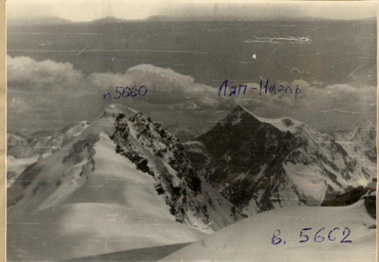
Summit of Peak 5662. View from the summit to the southwest. In the background, the Lyap-Nazar massif.

| Date | Sections traversed | Average steepness of section, ° | Route length, m | Terrain characteristics | Technical difficulty | Method of traversal and belay | Weather conditions | Departure, h | Bivouac, h | Walking hours | Rock pitons | Ice pitons | Bolts | Bivouac conditions | Daily ration weight |
|---|---|---|---|---|---|---|---|---|---|---|---|---|---|---|---|
| July 27, 1970 | R0–R1 | 7 | 7500 | From camp "3700" to left-bank moraine, then grassy slopes and scree | Simultaneous movement | Without belay | Clear | 12:00 | 17:00 | 5:00 | Stone slab platform on moraine | 750 g per person | |||
| July 28 | R1–R2 | 20 | 300 | Snow couloir (dense snow) | Easy section | Simultaneous belay, movement on crampons | Medium cloudiness | 4:00 | |||||||
| R2–R3 | 30 | 250 | Snow-ice couloir (dense snow) | Easy section, some medium difficulty, on crampons | Alternate belay via pitons and ice axe in exposed ice | — | 2 | ||||||||
| R3–R4 | 40–50 | 250 | Snow-ice couloir | Medium difficulty on crampons | — | 2 | |||||||||
| R4–R5 | 20–25 | 120 | Snow ascent | Easy section | Simultaneous movement | — | |||||||||
| R5–R6 | 50–60 | 150 | Destroyed rocks | Medium difficulty | Alternate belay via pitons and outcrops | — | 4 | ||||||||
| R6–R7 | 70–80 | 15 | Rocky walls, some ice | Challenging climbing | Pitons belay | — | 4 | ||||||||
| R7–R8 | 60 | 240 | Destroyed rocks | Medium difficulty | Belay via outcrops and pitons | — | 5 | ||||||||
| R8–R9 | 70 | 30 | Slab-like rock structure (unstable) | Challenging climbing | Pitons belay | — | 8 | ||||||||
| R9–R10 | 50 | 160 | Highly destroyed ridge | Climbing of medium difficulty | Mostly belay via | — | 1 | ||||||||
| R10–R11 | 60 | 90 | Pre-summit snow dome | Medium difficulty | Alternate movement, belay via ice axe | — | 13:00 | ||||||||
| July 29 | R11–R12 | Descent via ascent route to saddle | 14:20 | 19:00 | 2:40 | 6 | |||||||||
| R12–R13 | Descent from saddle to glacier moraine and base camp "3700" | 7:00 | 14:00 | 5:00 | |||||||||||
| Total: | 17 h | 22 | 4 |
Team Captain: Balakin A.V. Senior Coach: Povarnin P.I.