Ascent Passport
- Ascent type: rock climbing.
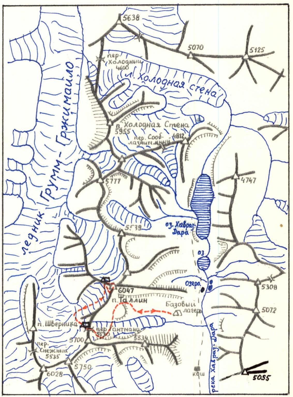
- Ascent area: Central Pamir, Yazgulem Ridge.
- Peak, its height, and ascent route: Peak 6047 m, from the saddle of the western ridge.
- Proposed difficulty category: 4B.
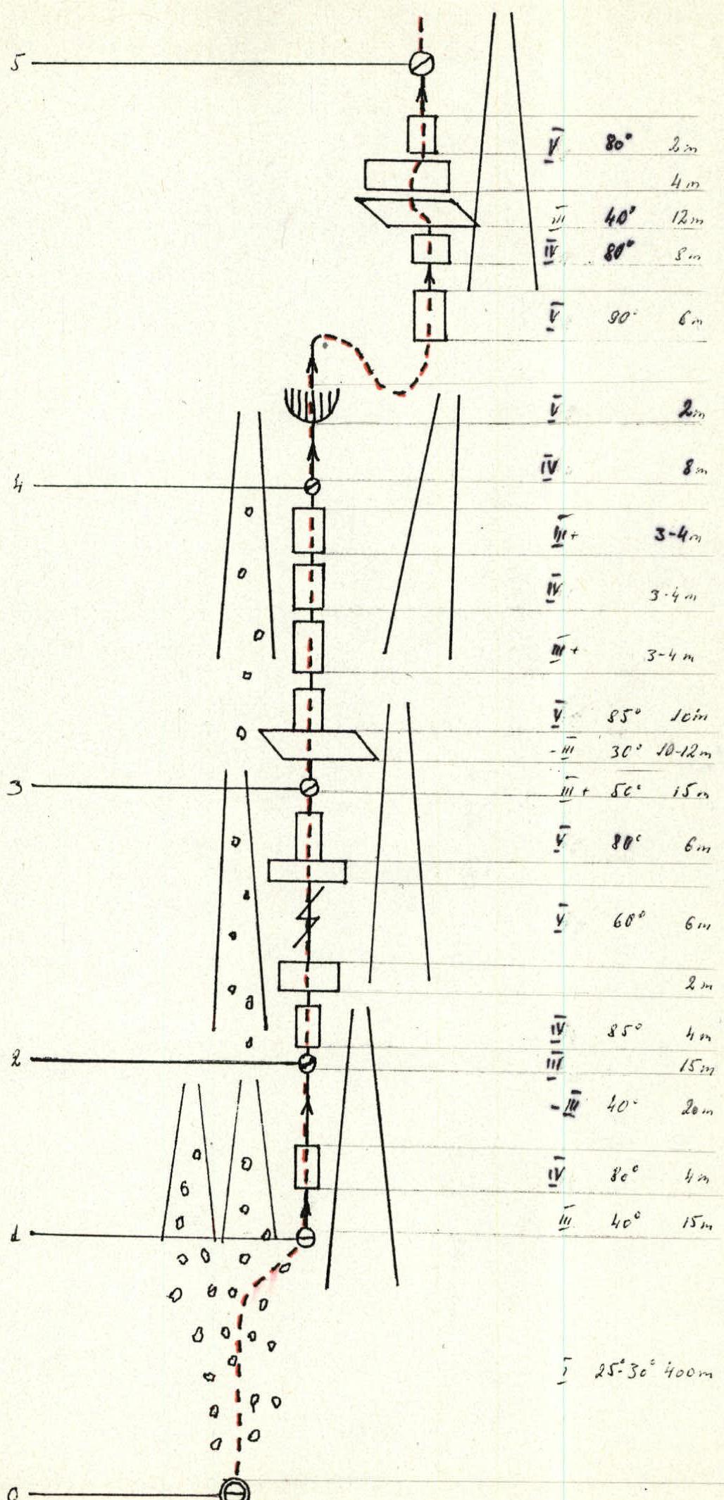
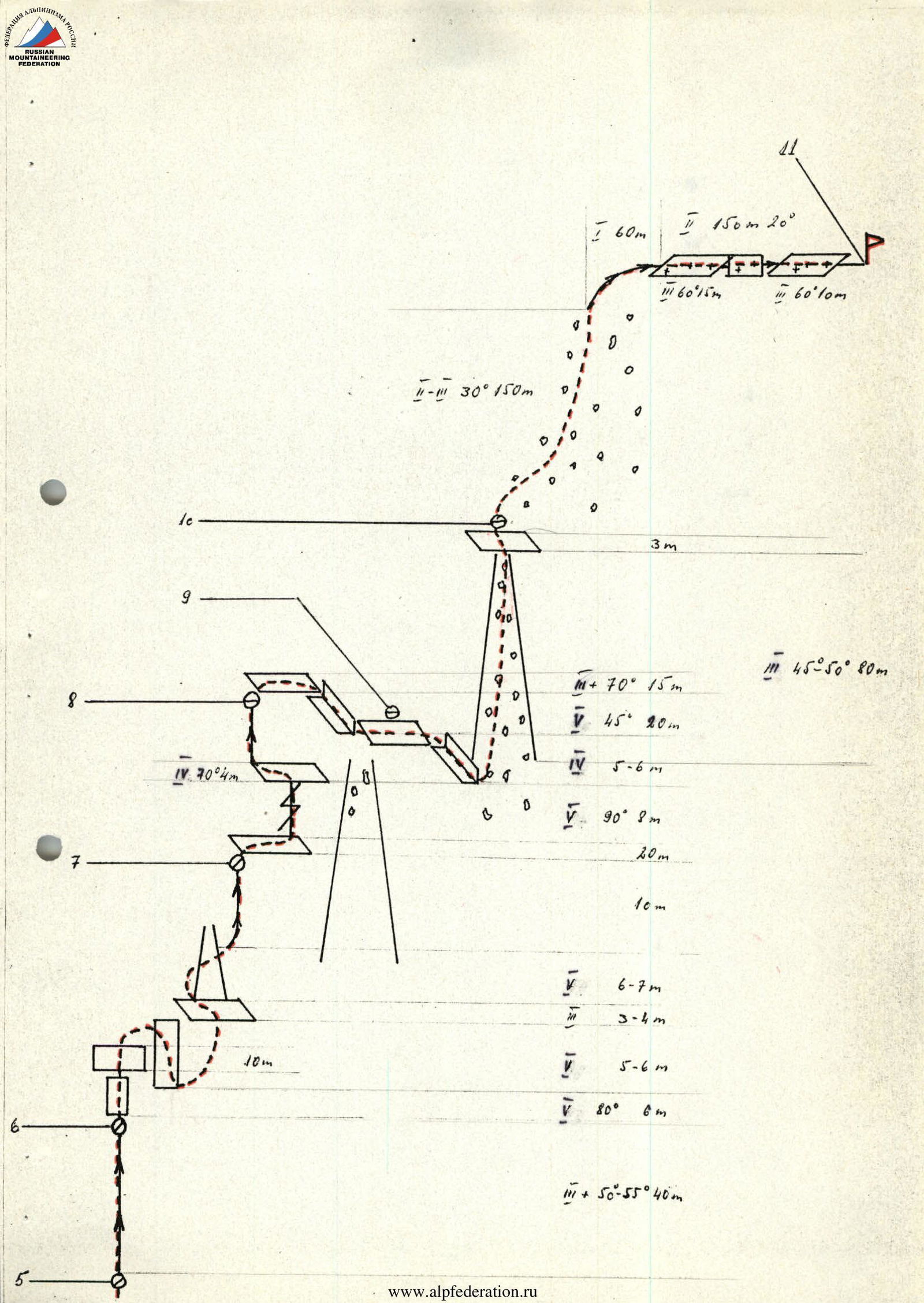
- Route characteristics: height difference 647 m, average steepness 43°, section lengths — I 460 m, II 225 m, III 334 m, IV 38 m, V 68 m.
- Pitons hammered: for belaying — rock II, ice —, bolted —; for creating ITO — rock 21.
- Number of climbing hours: 13 hours.
- Number of nights and their characteristics: none.
- Surname, name, patronymic of the leader and participants, their sports qualification: Künnap Jaak Aleksanrovich — 1st sports category, leader Kallavus Anu Helmutovna — 2nd sports category Stern Ante Kalyuovich — 2nd sports category Muru Kalev Manivaldovich — 1st sports category Paris Andres Petrovich — 1st sports category
- Team coach: Priimets Ilmar.
- Date of departure on the route and return: August 18, 1984, at 8:00 – August 18, 1984, at 21:00.
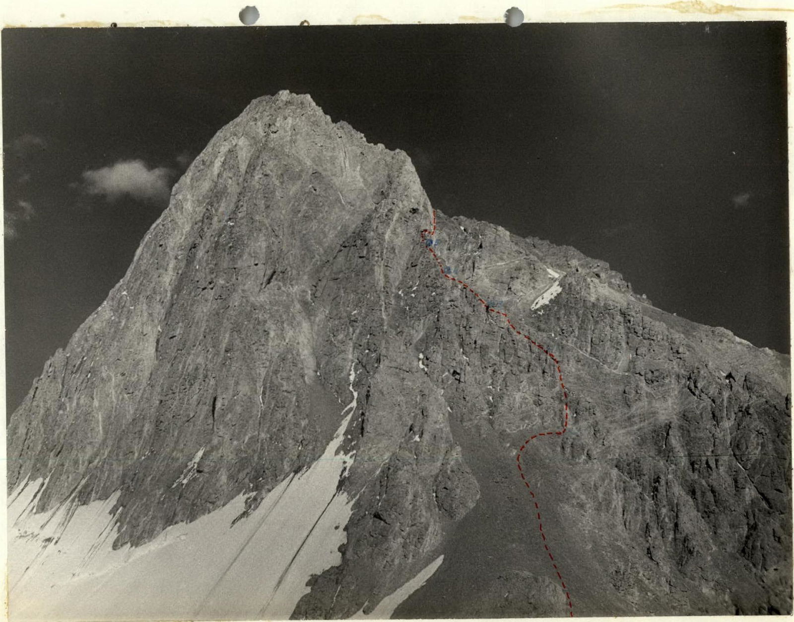
 Peak Tallinn (6047 m)
— along the 10–3 ridge.
— along the 3 ridge.
View from 10–3.
Peak Tallinn (6047 m)
— along the 10–3 ridge.
— along the 3 ridge.
View from 10–3.
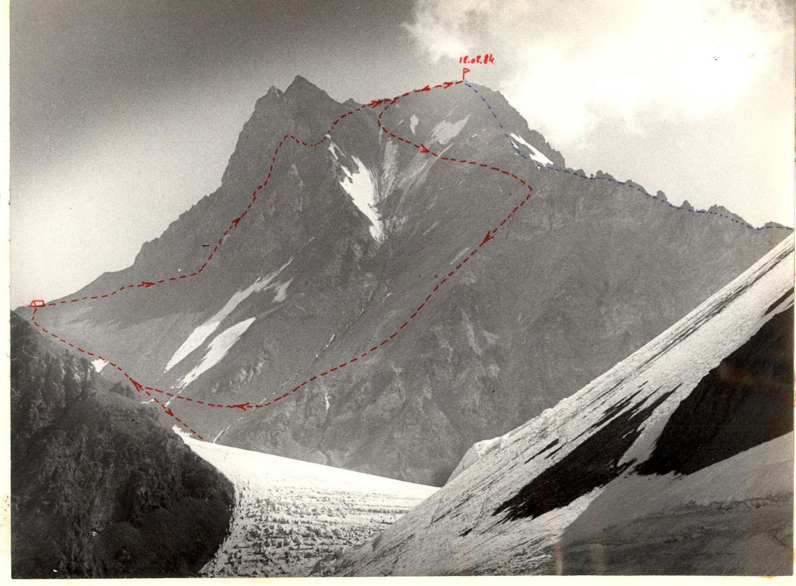
 Ascent from the base camp to Gantman's Pass, view from the east.
Schematic of the peak area: 6047 m
Central Pamir, Yazgulem Ridge
Brief explanation of the table
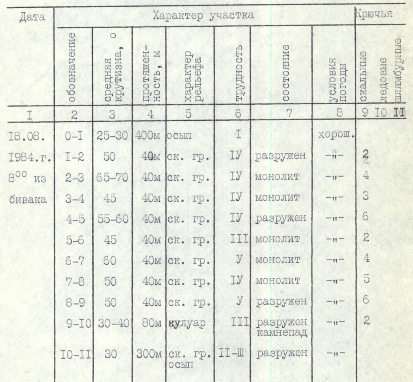
0–1 Start of the route from the bivouac — wide scree slope (400 m) towards the peak to the rocks. Stay to the right towards the ridge, leaving two nearby couloirs to the left. 1–2 Movement along the ridge, through broken rocks. In the middle of the section, there is a 4-meter slab. Variable protection (rock pitons). To the right of the ridge, there is a large, wide couloir. 2–3 Along the ridge, with 2–6 meter slabs. The rock is monolithic; variable protection (pitons). 3–4 Along the ridge, with slabs and good ledges. Variable protection (pitons). 4–5 Along the ridge into a depression, to the right under a complex slab (ladders desirable) and then along slabs. Variable protection (pitons). 5–6 Along the ridge. Medium rocks. Variable protection (pitons). 6–7 Along the ridge, through complex slabs. Stay to the right. Variable protection (pitons). Sections 0–7 remain in the shade until 14:00 in August. On sections 2–7, belay points are inconvenient. 7–8 To the right along a slab, up a crack, along a 4-meter slab to the left. Variable protection (pitons). 8–9 To the right along an inclined slab (70°). Down towards the start of a deep couloir, then traverse to a slab. 9–10 Down into a couloir. Then up the couloir. (In August, rockfall occurs from 12:00). Preliminary processing is advisable on sections 7–10. Movement is along fixed ropes using jumar. 10–11 Up 150 m along scree and to the right towards the peak. Along simple slabs and firn to the peak. There are convenient and safe areas for tents.
Table of main characteristics of the ascent route
August 18, 1984, at 8:00 from the bivouac.
| Designation | Average steepness, ° | Length, m | Terrain characteristics | Difficulty | Condition | Weather conditions | Rock pitons | Ice pitons | Bolted pitons |
|---|---|---|---|---|---|---|---|---|---|
| 0–1 | 25–30 | 400 | scree | 1 | good | ||||
| 1–2 | 50 | 40 | rocky ridge | 4 | broken | –"– | 2 | ||
| 2–3 | 65–70 | 40 | rocky ridge | 4 | monolithic | –"– | 4 | ||
| 3–4 | 45 | 40 | rocky ridge | 4 | monolithic | –"– | 3 | ||
| 4–5 | 55–60 | 40 | rocky ridge | 4 | broken | –"– | 6 | ||
| 5–6 | 45 | 40 | rocky ridge | 3 | monolithic | –"– | 2 | ||
| 6–7 | 60 | 40 | rocky ridge | 5 | monolithic | –"– | 4 | ||
| 7–8 | 50 | 40 | rocky ridge | 4 | monolithic | –"– | 5 | ||
| 8–9 | 50 | 40 | rocky ridge | 5 | broken | –"– | 6 | ||
| 9–10 | 30–40 | 80 | couloir | 3 | broken, rockfall | –"– | 2 | ||
| 10–11 | 30 | 300 | rocky ridge, scree | 2–3 | broken | –"– |
 View from the north-west.