4.12.75
ON ASCENT TO PIK OKTYABR'SKOY REVOLYUTSII VIA SOUTH RIDGE FROM YAZGULEM-DARA GLACIER THROUGH PIK 6254 m. A COLLECTIVE OF ALPINISM INSTRUCTORS FROM THE ARMED FORCES OF THE USSR.
THE ASCENT IS DEDICATED TO THE 50th ANNIVERSARY OF THE ARMED FORCES OF THE USSR.
1968
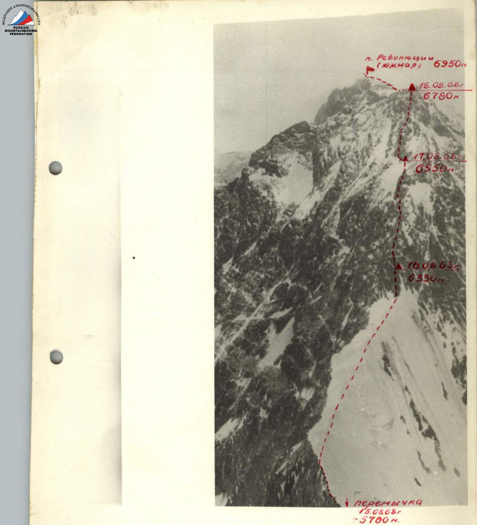
Photo 2. Pioneering ridge of Pik Revolyutsii. (Taken from the overnight stop on descent from Pik 6254 m.)
The objectives of our team's ascents in the 1968 season were Pik 26 Baku Commissars (6834 m) and Pik Revolyutsii (6974 m). These peaks had been visited by Soviet climbers several times before, but all ascents were made either from the Fedchenko Glacier or the Grumm-Grжимайло Glacier.
Our team's task was complicated by the fact that the chosen routes to these peaks started from the south, a region that Soviet climbers rarely explored.
Participants of the Armed Forces (AF) gathering began preparing for the expedition in the autumn of 1967.
The main directions were:
- Selecting a team capable of handling such challenging tasks.
- Selecting and preparing equipment and special food supplies.
- Developing a plan for organizing the ascents - schedules, communication, transportation means.
Since there were two teams at the AF gathering with adjacent routes, all preparations were carried out jointly. Both teams worked as a single unit until reaching the base camp at the Yazgulem-dara Glacier.
The plan included conducting the gathering and ascents from July 18 to August 24, 1968.
Studying the route presented significant difficulties due to the unknown nature of the region and lack of specific geographical data. To address this, aerial photography of the area was conducted, and the resulting materials were used for detailed study.
It was known that reaching the starting points of the ascents would be challenging. It was planned to drive from Osh to Muzkol and then to a possible point in the Kokuybel-su valley.
From there, it was intended to fly by helicopter to the southern slopes of the Yazgulem Ridge.
The geography of the action area was considered complex. The Bartang valley was poorly studied, and the location of the possible base camp was remote from roads and populated areas.
The southern slopes, along which the ascents were to be made, exceeded the height of the glacier tongues by more than 3000 m. These slopes were cut by steep walls, quite extensive in length, with numerous hanging glaciers. The upper parts of the walls had large ice-firn caps with significant overhanging sections (cornices).
Possible routes could be chosen along interrupted counterforts or ridges.
The nature of the path was primarily rock-ice. The rocks were predominantly limestone, significantly weathered, with sections of solid, monolithic blocks.
The routes for our teams were planned as follows:
- Team 1 - ascent to Pik Revolyutsii via the southwest wall.
- Team 2 (ours) - ascent via the south ridge of Pik 26 Baku Commissars (alternative - south ridge of Pik Revolyutsii).
The insufficient study of the area required extensive reconnaissance work to finalize the routes.
All this, despite the fact that several ascents had already been made to Pik Revolyutsii, including by some participants of our gathering, suggested that the overall sporting character of the southern slopes was complex and quite different from the paths from the north. We understood that our tasks would require a great deal of effort from each participant.
Additionally, the ascent area was unknown to us in terms of weather conditions.
This required particularly clear planning of all actions by both teams, comprehensive safety measures, and reliable communication.
The organizational plan for the gathering included:
- Shipping equipment from Moscow (June-July) and receiving it in Osh.
- Preparing equipment (gear, supplies, etc.) for shipment to the base camp.
- Traveling from Osh to the base camp (by car to the Kokuybel-su valley and by helicopter to the Yazgulem-dara Glacier).
- Establishing the base camp.
- Conducting necessary training ascents and reconnaissance under the routes.
- Preparing to depart on the planned route.
- Completing the route.
On August 5, 1968, ten members of the expedition went to Pik 6254 m for acclimatization. At the same time, three team members who had acclimatized on Pik Lenin (A. A. Artyukhin, V. N. Ovsyannikov, A. N. Putintsev) began reconnaissance under Pik 26 Baku Commissars to observe rockfall, avalanche patterns, and study the route in detail.
On August 8, 1968, both groups met at the base camp (3700 m). After discussing the ascent to Pik 6254 m, a coaching council was held, during which the results of the reconnaissance of the south ridge of Pik 26 Baku Commissars were reported. The reconnaissance group's opinion was unanimous: the path along the south ridge was dangerous due to rockfalls from the ice cap covering the peak.
The group also examined the alternative option - the south ridge of Pik Revolyutsii.
The reconnaissance revealed that the south ridge of the South Peak of Pik Revolyutsii descended to the northern slopes of Pik 6254 m. Detailed reconnaissance determined that the ascent to the south ridge was possible from the Yazgulem-dara Glacier via two paths:
- Ascent to the saddle between Pik Revolyutsii (South Peak) and Pik 6254 m from the Pik Revolyutsii Glacier along the wall.
- Ascent to Pik Revolyutsii via the south ridge through Pik 6254 m.
The first ascent option was considered dangerous due to avalanches and rockfalls from the hanging glacier on the wall of Pik 6254 m and rockfalls from Pik Revolyutsii.
A decision was made: the ascent to Pik Revolyutsii via the south ridge would proceed through Pik 6254 m. This was considered a logical, albeit longer, path and allowed for good interaction with our comrades ascending via the southwest wall, especially since the routes converged in the upper part.
The coaching council determined the following team composition: Team Leader: S. I. Artyukhin. Participants:
- A. A. Mikhailov
- V. N. Ovsyannikov
- A. N. Putintsev
- A. S. Chmykhov
Some changes were made to the storming group's composition compared to the initial plan: two participants from the reserve (Mikhailov and Ovsyannikov) were included.
All participants of the storming group had undergone acclimatization training with several overnight stays at altitudes around 6000 m:
- Artyukhin, Ovsyannikov, and Putintsev - on Pik Lenin during the parachute drop;
- Mikhailov and Chmykhov - during the ascent to Pik 6254 m.
According to the participants of the ascent to Pik 6254 m, the upper part of the ridge of Pik Revolyutsii presented a serious wall requiring a wide range of "various caliber" pitons.
The tactical plan for the ascent included:
- Assessing the team's preparedness and ensuring the ascent.
- Considering the route's nature and the time required to complete it.
- Anticipating unexpected changes in the situation on the route.
- Ensuring safety under the prevailing ascent conditions.
According to the tactical plan, it was decided not to establish a storming camp but to begin the ascent from the base camp with the following time allocation:
Day 1. Ascent to the saddle between Pik 6254 m and Pik 5670 m. Day 2. Traversing the ridge of Pik 6254 m; overnight stay near the summit. Day 3. Ascent to the summit of Pik 6254 m; descent to the saddle under the south ridge of Pik Revolyutsii. Overnight stay on descent. Day 4. Continuing descent. Overnight stay on the saddle between Pik Revolyutsii and Pik 6254 m. Day 5. Ascent to the south ridge of Pik Revolyutsii. Overnight stay on the ridge. Day 6. Ascent along the ridge to the "red wall." Overnight stay. Day 7. Passing the "red wall"; ascent to the "gendarme." Overnight stay. Day 8. Passing the "gendarme" and continuing to the South Peak of Pik Revolyutsii. Overnight stay. Day 9. Ascent to the Main Peak of Pik Revolyutsii via the South Peak. Descent towards the Grumm-Grжимайло Glacier. Days 10-11. Descent through the Grumm-Grжимайло Glacier to the Tanymas valley.
To ensure safety, a plan for interaction was developed between our team and the group led by V. Nekrasov, ascending via the southwest wall of Pik Revolyutsii, and the TurkVO team, ascending via the western ridge of Pik 6254 m, including scheduled signal communication between them. Additionally, our team was monitored by an auxiliary group at the base camp.
Both the organizational and tactical plans were executed. Even bad weather did not disrupt the team's plans, as the passage along the ridge of Pik Revolyutsii took four days instead of the planned five, thanks to a faster traversal of its lower part.
From August 10, the weather began to deteriorate, but as planned, on August 11 at 9:30, the team, fully equipped for the ascent, left the base camp, crossed the Yazgulem-dara Glacier in its middle section, and reached the terminal moraine of the unnamed Turkestan-type glacier descending from the saddle between Pik 6254 m and Pik 5670 m.
The path proceeds as follows:
- Initially along the left (orographically) lateral moraine of the glacier.
- Then along its median moraine, as rocks fall from the slopes of Pik 6254 m and Pik 5670 m.
- We move towards the couloir (R1) descending from the saddle. The couloir is ice-firn, 480 m long. In the upper part, there is pure ice (R2 ropes - 2 ice pitons).
At 18:15, we reached the 5150 m saddle. Overnight stay, control cairn. We cut out a platform in the ice ridge.
Over 9 working hours, we ascended 1500 m. At 21:00, we established signal communication with the base camp and Nekrasov's group via signal flares.
August 12. We depart at 9:30. It's cold, with strong winds and snow. The Mikhailov-Chmykhov rope leads. The ascent to the summit is familiar to them, having completed this path a few days earlier.
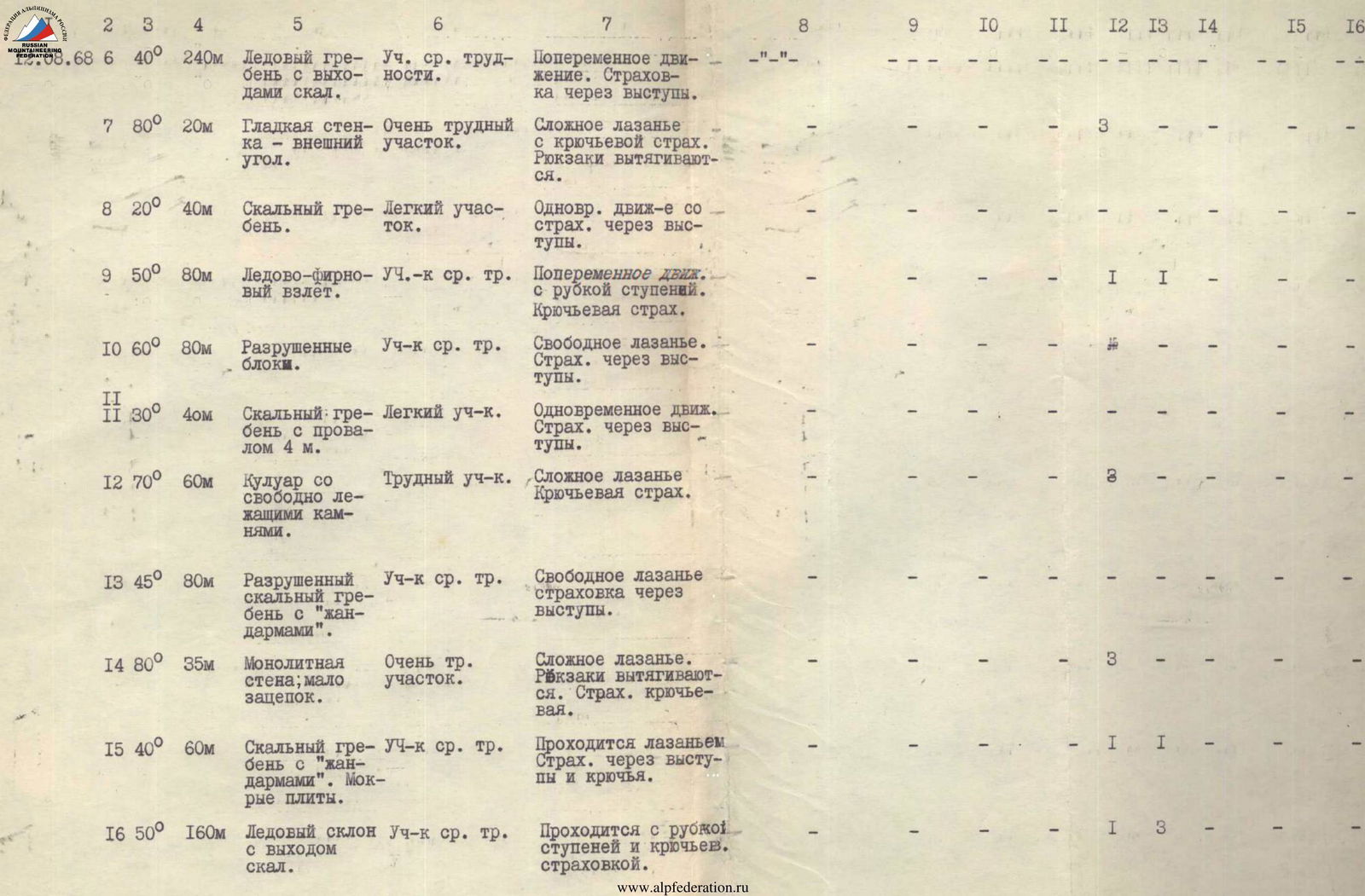
From the saddle, the path proceeds along a small ice ridge (5 m, 35°–40°) to weathered rocks (R2), leading to an ice-firn ascent (R3), with step-cutting in the upper part. After a short snow ridge, there is a weathered rock ridge (R4) with gendarmes. Ice is encountered. Two gendarmes are relatively small and are bypassed on the left; the 3rd gendarme is bypassed on the right via an ice ledge (R5), gradually widening. In the first third of the ledge, there is a smooth slab 10 m long, blocking the ledge - a challenging section. Beyond the ledge, an ice ridge with exposed rocks (R6) leads to a blunt external angle with smooth walls (R7). The angle is traversed without backpacks. Further along the rock ridge (R8), we reach an ice-firn ascent (R9). The ropes change. It's difficult to cut steps with heavy backpacks, especially at this altitude. After the ascent, there are large-block weathered rocks (R10) and a short rock ridge with a gap (R11), followed by a couloir (R12) leading left upwards. The base of the couloir is a slab with numerous "various-sized live" rocks. We drive pitons into the side walls of the couloir. Further along the weathered rock ridge with gendarmes (R13) (bypassed on the right), we reach a smooth wall (R14), traversed via complex climbing without backpacks due to the lack of handholds.
The weather worsens; wind is accompanied by fine snow. Above, the wall transitions into slabs forming a ridge (R15), not very pleasant to traverse, wet from the overlying ice-firn slope (R16). Steps are cut, and pitons are used. We move towards a weathered rock ridge with snow (R17), leading to an extensive firn plateau. After traversing one rope length, we stop for the night at 20:40.
Over 11 hours of work, we ascended about 1000 m and drove 19 pitons. At 21:00, we signal with a flare and go to sleep.
August 13. We depart at 10:00. Strong winds "aid" our movement, dispersing the fog. Firn fields on the summit ridge are steep, up to 45°; the 3rd ascent is a 60° firn wall, 50 m high. It's very challenging. After several similar ascents of 30–40 m (35°–40°), the 9th ascent leads to the summit of Pik 6254 m at 14:45.
After a quick snack, we begin our descent - first east along a snow ridge (R19) with massive cornices facing south, and then down a steep, snow-covered rock ridge (R20) to the north, towards the saddle between Pik 6254 m and Pik Revolyutsii. Snow begins to fall. Wind gusts are so strong that they blind.
Along a snow-firn slope (R21), we descend with sport climbing, and further from a smooth slab (R22), we rappel with a re-clip.
At 18:40, 80 m after the rappel, on an ice-firn slope (R23), we carve out a platform for the tent.
The altitude is around 6000 m. We drove 6 pitons during the day. Visibility is 20–30 m, but we still signal with a green flare at 21:00.
August 14. Snowfall of 20–25 cm occurred overnight, and the weather hasn't improved. It's not possible to depart. By evening, the wind subsides, but snow continues to fall.
August 15. We congratulate Chmykhov on his birthday. We depart at 9:00. Along an ice-firn slope (R24), we descend in three pitches. We clear snow, drive pitons. After a day of rest in the tent at such an altitude, it's hard to move. From the slope, we move to a rock ridge (R25). The rounded rocks are rough, similar to the Krasnoyarsk pillars, and practically have no handholds. We traverse with complex climbing, followed by 35 m of sport climbing descent.
A firn slope (R26) changes its steepness, transitioning into an ice slope (R27), where snow is almost nonexistent and is blown away by the wind. We establish a rope barrier. We approach a bergschrund (R28), which cuts across the slopes of the right cirque. We rappel; the last person sets up a self-releasing system, as leaving pitons is not possible - they'll be needed again.
After a slight ascent of 100 m, we reach the saddle (5700 m) between Pik 6254 m and Pik Revolyutsii at 18:15.
We begin constructing a platform, which takes 2 hours, but the effort is rewarded with excellent rest. We count the number of pitons driven (R17), signal with a flare, and go to sleep.
August 16. We depart at 8:30. Along weathered rocks (R30) and a small snow section (R31), we approach a steep wall (R32) ("gendarme"), bypassing which on very steep ice would be time-consuming. We traverse it head-on. After a gentle snow ridge with rocks (R33), along snow-firn and partially ice slopes of varying steepness (R34–R35), we reach steep weathered rocks (R36).
From here, as observed during the descent from Pik 6254 m, purely rock climbing begins, which doesn't promise to be easy. At 14:10, we hear voices: our comrades are working on the adjacent route.
This section has many "live rocks," so we must be particularly cautious.
After 35 m of wall (R37), composed of large blocks, along a weathered rock ridge (R38), proceeding slightly to the right, we approach the "finger." The "finger" is a small, sharp outcropping from the wall, which from below, from the Yazgulem-dara Glacier, appeared red during route reconnaissance. The overnight stop isn't ideal. It's 17:00, but continuing isn't sensible, as nothing better is visible ahead.
The Chmykhov-Mikhailov rope heads to process the wall; the others work on constructing a platform.
After 2.5 hours, the pair returns, having left ropes and 60 m of rappel line on the traversed sections, but the platform hasn't become more comfortable. We drive 7 rock and 1 ice piton and set up a tent. It's possible to semi-recline inside.
At 21:00, we establish the usual communication with the interacting group and the camp.
August 17
We depart at 10:00 - some inconvenience during packing, cold, and strong winds.
From the "finger," along a sharp rock ridge (R39), we approach a steep monolithic slab with an oblique crack (R40), 10-15 cm wide. We ascend directly upwards along the left rope, pulling up backpacks, to the wall into which the slab transitions, composed of large, smooth blocks.
There are small cracks in the wall where thin titanium pitons fit well.
To pull up backpacks, we set up a pulley system. Large blocks give way to smaller ones, but the steepness hardly decreases. This day is characterized by a high concentration of challenging sections.
Weathered rocks lead to an iced internal angle, the upper part of which is closed by a snow-covered slab (R43). The angle is traversed along its left part; the cork is bypassed. The first person is pulled up; the others follow with top-rope climbing.
The angle leads to a ridge heading towards the pre-summit tower. Initially along a sharp rock ridge with a small wall (R44) (pitons), and further along heavily snow-covered, weathered rocks and a scree ridge (R45–R46), we reach a slab covered with snow (R47). Powdery snow gives way underfoot, and there's nowhere to drive pitons. By driving several ice pitons, we establish a belay from the rock ridge (R46). After 25 m, the snow ends, but the slabs are iced. We struggle to find a crack for a piton, but eventually, this section is behind us, and at 18:30, we begin constructing a platform under the overhanging rocks.
The altitude is 6500 m; 29 pitons were driven during the day. At 21:00, we signal with a flare and go to sleep.
August 18
We start work at 9:30. From the overnight stop, we move left with a slight ascent:
- Complex traverse of a large, smooth slab (R48).
- Then upwards along a weakly defined ridge of slate slabs (R49) to an internal angle 6 m high, challenging to traverse due to the "uncomfortable" structure of the rocks (ceramic-like slate).
After the angle, the path proceeds slightly to the right along a rock ridge (R50) to a large wall (R51), composed of large blocks, from the base of which a narrow couloir with smoothed walls descends steeply to the left.
The wall (external angle) is traversed via complex climbing due to a winding crack. Beyond it, along snow-dusted, relatively easy rocks (R52), we approach a vertical, wide chimney with a cork (R53), 10 m from its start.
The chimney is traversed without backpacks along its right part; the cork is bypassed on the left, and one can stand on it.
Further, a steep rock ridge with three "gendarmes" leads to the pre-summit tower.
- The first "gendarme" is a massive, overhanging rock 3 m high, traversed with a shoulder stand.
- The second "gendarme" is a 12 m wall with a narrow (0.5 m) chimney in the middle.
- The third "gendarme" is a 6 m slab across the entire ridge.
It's unpleasant to descend from the last one: a 2.5 m vertical drop without a single crack or handhold. We stop for the night under the tower at 19:30. We construct a platform, driving pitons for belay and to stretch the tent. A total of 25 pitons were driven during the day. At 21:00, we signal with a flare, now only for the group observing us from the base camp.
August 19
The night at such a high altitude (6800 m) passed calmly. Towards morning, the weather slightly deteriorated: occasional snowfall.
We depart at 9:30. A straightforward ascent to the South Peak of Pik Revolyutsii begins, which we reach at 10:40.
Pik Revolyutsii is a massive array consisting of three peaks, with the highest (Main Peak, 6974 m) accessible by traversing the snow-firn slopes of the South and East Peaks (R58–R59).
The ascent to the Main Peak proceeds from the saddle between the East and Main Peaks along a long snow slope to the highest rock point of the massif.
At 15:10, we reach the summit, signal with a flare about successful completion of the route, and retrieve a note left by V. Nekrasov's group, which had reached the summit two days earlier via an excellent route along the southwest wall.
At 15:35, we begin our descent to the saddle and further along the path of the first ascenders - east onto the Grumm-Grжимайло Glacier. We establish a bivouac at 21:00, not reaching the glacier by 5 rope lengths.
August 20
We depart at 10:00. Very cold, strong winds. Descent to the upper reaches of the glacier via an ice slope with sport climbing. Avoiding seracs and crevasses, we reach the glacier's turn to the north. Beyond the turn, on the lateral moraine, we settle for the night.
August 21
We depart at 5:30. Where the glacier turns east again, due to numerous crevasses, we move to the left (orographically) lateral moraine and descend along it to the terminal moraine by 12:00, reaching an altitude of 3300 m.
Here, we are met by our expedition comrades. We receive congratulations, have a snack, and are flown by helicopter back to the expedition's base camp in the Kokdzhar valley.
The entire route to the Main Peak of Pik Revolyutsii took 64 working hours; 102 rock and ice pitons were driven.
After completing the route, the team thoroughly analyzed the path taken. Participants compared the route with others they had previously completed, both technically challenging and high-altitude.
By unanimous agreement among the team participants, the route to Pik Revolyutsii via the South Ridge, in terms of its technical characteristics, conditions of passage, length, and altitude, should be classified as a route of the highest category of difficulty.
The team members demonstrated themselves to be mature athletes with good technical and tactical preparation. Throughout the ascent, the team acted as a single, cohesive unit, capable of undertaking ascents of any complexity, which ensured the success of this climb.
CAPTAIN OF THE USSR ARMED FORCES TEAM, USSR SPORTS MASTER (S. ARTYUKHIN)
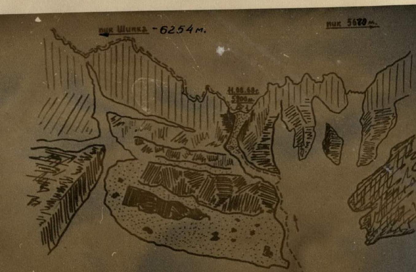
Munkl — 6254 m
Munkl — 5156 m
| DАТОБЫЕВА | ||||||||||||||||||
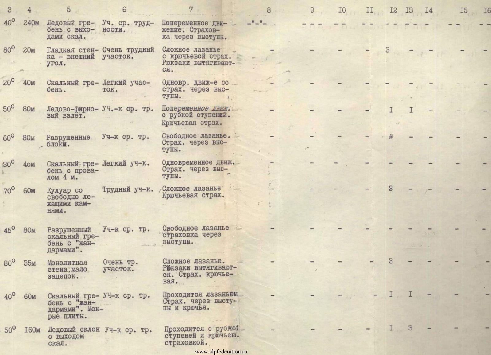
| R | Length and average steepness of section | Characteristics of sections and conditions of their passage by relief character | Technical difficulty | Method of overcoming and belaying | Notes | Date and time of start | Time of stop at bivouac | Working hours | Rock pitons | Ice pitons | Bolts | Night conditions | Daily ration weight |
|---|---|---|---|---|---|---|---|---|---|---|---|---|---|
| 41 | 75° – 40 m | Large smooth blocks without handholds. | Very difficult section | Complex climbing with piton belay | 5 | 1 | - | - | - | ||||
| 42 | 60° – 40 m | Weathered rocks. | Steep rocks. | Complex climbing with piton belay | 3 | - | - | - | - | ||||
| 43 | 80° – 35 m | Iced internal angle with a cork. | Very difficult section | Complex climbing. Belay via pitons. Backpacks pulled up. | 6 | - | - | - | - | ||||
| 44 | 55° – 10 m | Rocky ridge with a 5 m wall. Overhangs. | Steep rocks. | Complex climbing with piton belay. | 2 | - | - | - | - | ||||
| 45 | 50° | Heavily weathered rocks with snow. местами осыпи. | Moderately difficult section | Free climbing with belay via outcrops. | - | - | - | - | - | ||||
| 46 | 60° | Rocky ridge. Small walls. | Difficult section | Climbing with piton belay. | 2 | - | - | - |