REPORT
Red Banner Turkestan Military District

ON THE FIRST ASCENT OF "SHIPKA" PEAK 6254 m VIA THE WESTERN RIDGE FROM YAZGULEM-DARA, CATEGORY 5B
The route was claimed for the primacy of the Armed Forces of the USSR in the high-altitude category. Tashkent – 1968
Shipka Peak (6254 m) is located in the upper reaches of the Yazgulem-Dara River, in the southern spur of the Yazgulemsky Range, in the ridge extending from Peak October Revolution (6974 m). The most accessible approaches to the peak are from the Yazgulem-Dara Glacier. Only one route of category 4B difficulty (approximately) had been previously laid to the peak, via the southern ridge from the col between Shipka Peak and peak 5682 m.
The group believed that the most interesting and challenging route could be laid via the western ridge. Preliminary reconnaissance of the route revealed that the route to Shipka Peak is a sharply rising ridge with two horizontal sections. There are two towers on the ridge:
- the first is in the middle section, over 300 m high;
- the second, the summit tower, is over 600–700 m high.
The ridge section of the route features cornices. Access to the route is possible from the hanging glacier located between the western and southwestern ridges of Shipka Peak.
Preliminary assessment of the route's difficulty is 5B. The tactical plan for the ascent had almost no deviations during the route, except for a one-day delay (August 14, 1968 – sheltering on the glacier due to bad weather). Weather conditions during the ascent, except for August 14, 1968, were satisfactory for the climbers: absence of low temperatures, snow, fog, and strong gusty winds. The sky was occasionally covered with cumulus clouds.
The participants of the ascent had completed several joint ascents of categories 3–5 in the season, participated in rescue operations on Lenin Peak (transporting Morozov), and twice in 1968 reached altitudes above 6000 meters. By the time of the ascent, the group was in excellent physical condition.
Considering the above, the coaching council of the USSR Armed Forces expedition approved the group's composition for the ascent:
- Kharechko N.G. – leader, 1st sports category
- Fink V.A. – deputy leader, 1st sports category
- Aizin V.B. – participant, 1st sports category
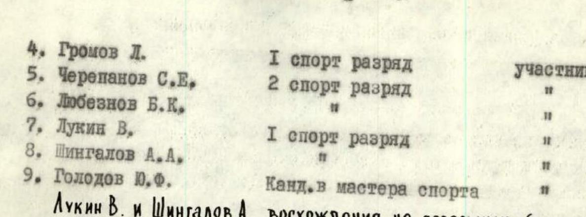
- Gromov L. – participant, 1st sports category
- Cherepanov S.E. – participant, 2nd sports category
- Lyubeznov B.K. – participant
- Lukin V. – participant, 1st sports category
- Shingalov A.A. – participant
- Golodov Yu.F. – Candidate Master of Sports
Lukin V. and Shingalov A.A. did not complete the ascent (see below).
First Day — August 12, 1968
Departed from the base camp at 3700 m at 16:00.
Followed the trail along the moraine upstream for 1 hour, crossed the Yazgulem-Dara Glacier, and reached a lake located between the moraine wall and the slope. Height 3900 m. Time taken for the approach: 3 hours.
Set up a night camp.
Second Day — August 13, 1968
Departed at 9:00. From the lake, ascended an osypnoy slope (2 hours 30 minutes) to the ridge, then traversed the southwestern ridge of Shipka Peak via osypnoye polki towards the hanging glacier, and reached the tongue of the glacier. After passing under the glacier via a couloir, emerged under a rock wall (10–12 m). From here, moved in rope teams.
Ascended the wall to reach an osyp, which led to the body of the glacier with a slope of 40–50°. With step-cutting and variable movement, reached a relatively gentle firn field 300–350 m long. Then, navigated through an icefall, taking 2 hours, and reached the next firn field with crevasses. With careful belaying, approached the start of the route.
Weather deteriorated, set up a night camp. Time: 17:00, height: 4600 m. The approach to the route took 10 hours.
Third Day — August 14, 1968
Snow fell during the night. Fog and snow in the morning. Rocks were snow-covered. Planned to depart at 10:00, then at 12:00. Weather did not improve. Decided to wait out the day. Participant Shingalov A. felt unwell. The Golodov-Aizin rope team departed at 16:00 for route reconnaissance. The initial variant for reaching the ridge was deemed unsuitable due to heavily damaged rocks.
Fourth Day — August 15, 1968
The Kharechko-Fink rope team departed at 9:00 for route processing, the rest at 10:00. The ailing Shingalov descended with Lukin V. The weight of the backpacks increased.

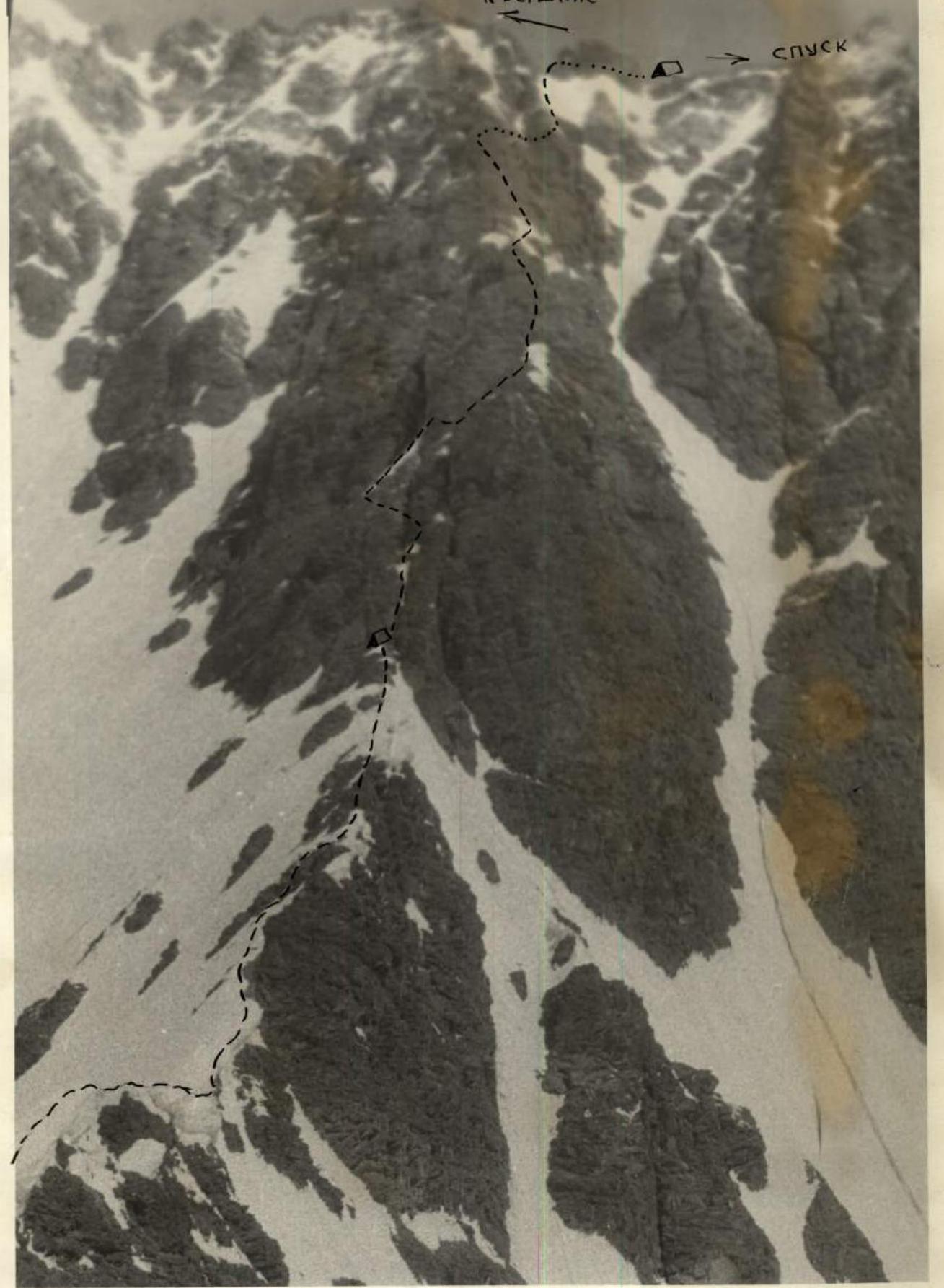
Reference point – Shipka Peak area.
Section R0–R1. Ascended a caldera with caldaspores, simultaneously approached the gorge of the couloir and emerged onto stepped rocks.
Section R1–R2. Ascended rocks with 5 ropes, adhering to the left side, under the yellow (40 m) wall. The section was traversed simultaneously.
Section R2–R3. A smooth monolithic wall composed of marble was ascended first in crampons without a backpack. The ascent utilized mainly pitons. Climbing started along a weakly expressed internal angle, then the steepness increased to 87–90°, with an exit under a rock overhang, which was bypassed with a pendulum swing left (2 m) onto a 5–7 cm wide ledge, and then upwards to a platform where a belay stance was established. Participants ascended via the rope ladder, and backpacks were hauled up (photo № 2). This was the most challenging section of the route.
Section R3–R4. Ascended an inclined ledge right into a couloir (30 m), with simultaneous movement and belaying through outcrops.
Section R4–R5. Ascended the left side of the couloir via snow-covered destroyed rocks, with two ropes, to a rocky island.
Section R5–R6. The rocky island was ascended in its middle part via a wide crevice with piton belaying. Ropes were fixed.
Section R6–R7. Further ascended a steep ridge with caldaspores (50–70 cm), with two ropes, leading to a ridge that approached the first tower.
Section R7–R8. Moved along the ridge composed of blocks without significant difficulty. Movement was simultaneous, with belaying through the ridge.
Section R8–R9. Bypassed a snow-ice cornice along a cushion.
Section R9–R10. From the cornice, ascended a steep osypnaya polka to a couloir, then up the couloir to a small wall with ice. Ascended the left wall of the couloir to reach the ridge, where a night camp was established.
- Time: 18:00
- Height: 5080 m
- First control point
Took 8 hours 30 minutes of walking time to cover 18.5 ropes, 480 m vertically. 21 pitons were hammered.
Fifth Day — August 16, 1968
Section R10–R11. Departed at 9:30. From the night camp, ascended a steep ridge composed of large blocks with piton belaying, one rope (photo № 3).
Section R11–R12. The ridge leveled out, followed by 70 m of simultaneous movement, leading to a monolithic sheer wall with a 0.2–0.3 m wide horizontal ledge.
Section R12–R13. Ascended the ledge with belaying to a narrow couloir, where ropes were fixed.
Section R13–R14. The couloir transitioned into an internal angle. Ascended straight up (75 m) to a detached block.
Section R14–R15. Traversed along the wall to the next block, 1–1.5 m high, establishing a belay point.
Section R15–R16. Descended 2 m from the block into an icy couloir with rocky islands. With piton belaying and step-cutting, approached a 3-meter wall – a point for fixing ropes. The wall was ascended with assistance, followed by 10 m of movement to a 5-meter ice-covered slab.
After removing ice from handholds, ascended above the slab and reached a rocky overhang.
Section R16–R17. Bypassed the overhang on the left, emerging onto rocks with rime ice, which led to the summit of the first tower. Then followed a ridge section.
Section R17–R18. The ridge was narrow, steeply sloping on both sides, with a snow slope below to the left at an angle of 65–70° (photo № 4). The ridge section was technically straightforward but psychologically challenging. The ridge featured minor rock outcrops and steep ascents up to 50°. Progress along the ridge required great attention and mental tension. 10 ropes of alternate movement on ropes led to a pinnacle with a wall (12 m).
Section R18–R19. Descended from the ridge into an icy depression under the pinnacle. Established a belay point here (ice screws). Ascended the wall with step-cutting and belaying.
Section R19–R20. Reached the ridge again, with cornices (100 m). This part of the ridge was steeper, with smaller cornice overhangs and more firn on the ridge. Belaying was through pitons and an ice axe. Movement was alternate on ropes. The ridge led to a narrow ledge under the summit tower (photo № 5). Here, there was a possibility to set up a camp, which was not visible from higher up.
Night camp:
- The first tent (4 people): established between a wall and a block, with a sitting arrangement, legs at head level, the tent's ridge suspended on the wall.
- The second tent (3 people): set up on a ledge, in a semi-sitting position, leaning against the wall.
Both tents had double ropes stretched between them, with everyone on belay. 12 pitons were hammered for the night camp. Time: 20:00. Height: 5435 m.
Took 10 hours to cover 21 ropes, 405 m vertically, hammering 29 pitons and 6 ice screws.
Sixth Day — August 17, 1968
Section R20–R21. Departed at 10:00.
From the night camps:
- ascended a narrow chimney (1 m) with ice at the bottom;
- with piton belaying;
- two ropes;
- movement on handholds.
Work was challenging due to altitude. Led to a ledge where belaying and ropes were established.
Section R21–R22. Traversed along the ledge, with simultaneous movement – one rope, where the ledge disappeared at an icy chimney. The rope was looped around an outcrop, and a pendulum swing was used to bypass the chimney, followed by a traverse to snow-covered rocks.
Section R22–R23. The section was in shade, requiring snow to be cleared to find handholds or cracks, with cold hands. Two ropes of alternate movement led to the ridge, where all participants gathered.
Section R23–R24. Ascended the ridge simultaneously with belaying through outcrops to a smoothed wall (17 m).
Section R24–R25. The first climber wore Vibram shoes. Monolithic rocks at the base lacked cracks, followed by:
- a hammered piton as a foothold;
- a move left to the top of the wall.
Ropes were fixed.
Section R25–R26. From here, ascended steep slabs with narrow ledges covered in small stones, left and up to the ridge, one rope.
Section R26–R27. Ascended the ridge to a snowy cornice, which was bypassed from below, emerging to a sheer edge. Established a belay point.
Section R27–R28. From this point, the further route was visible – a traverse under the wall to a detached stone (1.5 versts). The traverse led under a wide rocky couloir with ice; the left part was ice-free – wet and sunlit.
Section R28–R29. The first climber ascended in Vibram shoes without a backpack. From the stone, ascended the left part of the edge via dry rocks to a 5-meter sheer wet slab, with piton belaying, emerging to a smooth 10-meter internal angle (requiring chocks). Climbing was very challenging due to difficulty, fatigue, and altitude. Then, moved left onto wet slabs under an overhang.
One participant followed, and the first climber ascended further. Here, piton belaying was used, and ropes were fixed.
Section R29–R30. Bypassed the overhang (left) to emerge into a wet internal angle with crumbling rocks, leading to the ridge. Established a belay point. The rest followed the ropes for 80 m. Even on ropes, progress was extremely challenging (all were wearing backpacks). This section primarily required chocks.
Section R30–R31. Further ascended a sharp ridge with cornices for 40 m. Led to a pinnacle with a 5-meter wall.
Section R31–R32. Ascended the wall via a diagonal crevice from left to right, emerging onto the ridge.
Section R32–R33. Two ropes of narrow corniced ridge with ascents up to 50° led to a 10-meter double-sided cornice.
Section R33–R34. With belaying through two ice axes, broke through the cornice, and sat on the remaining snow blade, emerging onto the ridge and further onto an osypnoy slope.
Section R34–R35. This path presented no difficulty, and 150 m of simultaneous movement led to the main ridge approaching Shipka Peak. Time: 20:30. Established platforms on the osyp, signaled with a flare, and rested. Height: 6135 m.
Took 10 hours to cover 18.5 ropes, 650 m vertically, hammering 37 pitons.
Seventh Day — August 18, 1968
Section R35–R36. Departed at 6:10. Ascended firn fields with steep (up to 60°) ascents 20–30 m high, with simultaneous movement, to the summit of Shipka Peak (6254 m). Reached the summit at 8:00. Very cold, with freezing feet. Found a note from the group led by Artyukhin S.I., who were ascending Peak October Revolution. Returned to the night camp at 9:00. Began descent via the southern ridge, category 4B (approximately), at 10:00.
DESCENT
Snowy
Section R36–R37. Descended firn fields with ascents, simultaneous movement.
Section R37–R38. Descended via ropes down a steep icy ascent covered in wet snow. On this section, ice screws were hammered, and the last person descended in crampons. Below, traversed a couloir via a cut step.
Section R38–R39. Further descended a rocky ridge with wet slabs, bypassing pinnacles on the right, with five ropes of alternate descent. Belaying was through pitons and outcrops.
Section R39–R40. Descended a narrow rocky ridge with snow sections, two ropes, simultaneously.
Section R40–R41. Descended a relatively gentle rocky ridge, bypassing pinnacles on the right, with seven ropes and alternate belaying.
Section R41–R42. Descended three ropes down a steep caldaspore ascent with belaying through an ice axe.
Section R42–R43. Further descended a rocky, destroyed ridge with careful belaying (live rocks) to the start of the ice from the col between Shipka Peak and peak 5682 m.
Section R43–R44. Descended an icy ascent initially with step-cutting, then via glissade to the col.
Section R44–R45. From the col, descended into a snow-ice couloir. The upper 200 m was icy – traversed with belaying, the last person descended in crampons. Further descended onto snow, then onto the glacier. Time: 17:00. Returned to the base camp (3700 m) at 20:00 on August 18, 1968, completing the ascent.
Equipment Used During the Ascent
- Tents – 2: 1 high-altitude, 1 "pamirkа".
- Sleeping bags – 2: 4-person capacity.
- Main rope – 3 x 40 m.
- Auxiliary rope – 1 x 50 m.
- Rock pitons (factory-made) – 8.
- Titanium pitons – 12.
- Titanium chocks – 4.
- Carabiners – 14 individual + 12 working.
- Hammers – 2.
- Ice axes – 1.
- Repschnur – 10 m.
- "Febus" primus stove – 2.
- Gasoline – 5 liters.
- Ice screws (factory-made) – 4.
- Signal flares – 10.
- Crampons and Vibram boots.
Provisions were calculated at 0.7 kg per day for 7 days, totaling 34.3 kg. Equipment weighed 46 kg. Backpack weight did not exceed 15–17 kg.
Recommendations for future climbers:
- Pay attention to the selection of pitons (chocks).
- Follow the route as traversed by the first ascenders, as there are no other suitable places for camping on the route.
Communication with the observation group in the camp at 3700 m was maintained using signal flares.
The group assessed the route as category 5B.
“Kharechko N.G.: – ‘I have not encountered more challenging routes’”.
Fink V.A.: “Consider that Shipka is more challenging and complex than SAGU, category 5B, although the ascents differ in class”.
Golodov Yu.F.: – “The route deserves the highest category; it is serious and complex, technically similar to Chapdara, category 5B, the northern ridge”.
Nekrasov V.P.: “The route is combined, sufficiently complex, and deserves the evaluation you have given”.
Excerpt from the ascent debriefing protocol.
Table
Main Characteristics of the Ascent Route
Route SHIPKA (6254 m) 5B + 1 (approximately).
Characteristics:
- Height difference: 1704 m, including complex sections – 549 m (+ 12 ropes on the ridge section).
- Average steepness of the route: 47°, including complex sections – 76°.
| № | Date and Section | Average Steepness of Section | Route Length | Section Characteristics and Passage Conditions (By Relief Character) | Section Characteristics and Passage Conditions (By Technical Difficulty and Movement Method) | Section Characteristics and Passage Conditions (By Belaying Method) | Weather | Time (Departure) | Time (Night Camp) | Walking Hours | Pitons (Rock) | Pitons (Ice) | Pitons (Bolts) | Night Camp Conditions | Daily Ration (kg) |
|---|---|---|---|---|---|---|---|---|---|---|---|---|---|---|---|
| August 16 | 0.7 | ||||||||||||||
| First Day of Ascent. Height 4600 m. | |||||||||||||||
| 1 | R0–R1 | 35–40° | 5 versts | Caldera, firn, caldaspores | Simultaneous, easy | Outcrops, pitons | Good | 9:00 | |||||||
| 2 | R1–R2 | 55–60° | 4 versts | Inclined slabs, stepped rocks | Medium difficulty | Pitons | 5 | ||||||||
| 3 | R2–R3 | 85–90° | 1 verst | Smooth monolithic wall | Very difficult, rope ladder, backpacks hauled | Chocks, pitons | 7 | ||||||||
| 4 | R3–R4 | 45–50° | 30 m | Ospyannaya polka | Medium difficulty | Pitons, outcrops | 1 | ||||||||
| 5 | R4–R5 | 50–60° | 1 verst | Caldaspore slope with rock outcrops | Simultaneous, medium difficulty | Outcrops, pitons | 2 | ||||||||
| 6 | R5–R6 | 65–70° | 1 verst | Rocky island with wide crevices | Rope ladder, difficult | Titanium chocks | 3 | ||||||||
| 7 | R6–R7 | 45–50° | 1.5 versts | Snow-caldaspore ridge | Rope ladder, medium difficulty | Through ice axe | 2 | ||||||||
| 8 | R7–R8 | up to 45° | 2 versts | Narrow ridge composed of blocks | Simultaneous, easy | Outcrops, blocks | |||||||||
| 9 | R8–R9 | 10 m | Cushion of cornice, firn | Easy | Ice axe, outcrops | ||||||||||
| 10 | R9–R10 | 50–60° | 2 versts | Ospyannaya polka, couloir with ice | Medium difficulty | Blocks, pitons | 18:00 | 8:30 | 3 | Platforms on ridge | 0.7 | ||||
| Second Day. Height 5080 m. | |||||||||||||||
| 11 | R10–R11 | 50–60° | 1 verst | Ridge of large blocks | Medium difficulty | Pitons, outcrops | Good | 9:30 | 4 | 0.7 | |||||
| 12 | R11–R12 | 25–30° | 70 m | Ridge | Simultaneous, easy | Outcrops | |||||||||
| 13 | R12–R13 | 85° | 15 m | Horizontal ledge | Rope ladder, medium difficulty | Pitons | Good | 5 | |||||||
| 14 | R13–R14 | 65–70° | 2 versts | Couloir transitioning into internal angle | Difficult, rope ladder | Pitons, chocks | 2 | ||||||||
| 15 | R14–R15 | 70–75° | 1 verst | Inclined disappearing ledge | Medium difficulty | Outcrops, pitons | 9 | ||||||||
| 16 | R15–R16 | 65–70° | 70 m | Icy couloir with rock outcrops | Difficult, alternate movement, rope ladder | Pitons, step-cutting | 3 | ||||||||
| 17 | R16–R17 | 50–55° | 1 verst | Rocks covered in ice | Difficult, rope ladder | Pitons | 2 | 3 | |||||||
| 18 | R17–R18 | 10°, ascents up to 50° | 9.5 versts | Snow-ice cornices with rock outcrops | Alternate movement, difficult, psychologically challenging | Ice axe, pitons | 3 | 1 | |||||||
| 19 | R18–R19 | 75–80° | 12 m | Pinnacle, wall covered in ice | Difficult, rope ladder | Pitons | 20:00 | 10:00 | 12 (see text) | Semi-sitting, tents suspended on ledge | |||||
| 20 | R19–R20 | 25° | 2.5 versts | Corniced ridge with rock outcrops | Difficult, psychologically challenging. Alternate movement | Pitons, ice axe | |||||||||
| Third Day. Height 5485 m. | |||||||||||||||
| August 17 | 0.7 | ||||||||||||||
| 21 | R20–R21 | 70–75° | 1 verst | Narrow chimney with ice | Difficult, rope ladder | Piton belay | Good | 9:00 | 4 | ||||||
| 22 | R21–R22 | 60° | 2 versts | Wall with ledges | Medium difficulty | Pitons, outcrops | 3 | ||||||||
| 23 | R22–R23 | 65–70° | 85 m | Snow-covered rocks | Difficult, alternate movement, rope ladder | Pitons, chocks | 8 | ||||||||
| 24 | R23–R24 | 30° | 1 verst | Sharp ridge | Medium difficulty | Outcrops | 0.7 | ||||||||
| 25 | R24–R25 | 90° | 17 m | Smoothed wall on edge | Very difficult, rope ladder | Pitons | 3 | ||||||||
| 26 | R25–R26 | 70–75° | 1 verst | Inclined slabs | Difficult, rope ladder | Pitons | 4 | ||||||||
| 27 | R26–R27 | 20° | 55 m | Ridge with cornice | Simultaneous, medium difficulty | Pitons, outcrops | |||||||||
| 28 | R27–R28 | 70–85° | 1.5 versts | Destroyed rocks, ice | Medium difficulty | Pitons, outcrops | 1 | ||||||||
| 29 | R28–R29 | 80–85° | 1 verst | Edge, smoothed wet rocks | Very difficult | Pitons, chocks | 7 | ||||||||
| 30 | R29–R30 | 75–80° | 1 verst | Internal angle, crumbling rocks, water | Difficult | Pitons, chocks | 6 | ||||||||
| 31 | R30–R31 | 80° | 1 verst | Sharp ridge with cornice | Medium difficulty | Outcrops | |||||||||
| 32 | R31–R32 | 75–80° | 5 m | Wall with crevice | Difficult | Pitons | 1 | ||||||||
| 33 | R32–R33 | 30°, ascents up to 50° | 1.5 versts | Corniced ridge | Medium difficulty | Ice axe | |||||||||
| 34 | R33–R34 | 5–7° | 10 m | Double-sided cornice | Very difficult, alternate movement | Ice axe | Good on ridge with osyp | ||||||||
| 35 | R34–R35 | 45–50° | 150 m | Snow-covered rocks with ice section | Medium difficulty | Simultaneous, outcrops | 20:30 | 10:30 | |||||||
| August 18 | 0.7 | ||||||||||||||
| Fourth Day. Height 6135 m. | |||||||||||||||
| 36 | R35–R36 | up to 60° | 1300 m | Firn field, steep snowy ascents | Medium difficulty | Simultaneous | Good | 6:10 | 0.7 | ||||||
| Reached the summit of Shipka Peak 6254 m on August 18, 1968, at 8:00. Returned to the night camp at 9:00. | |||||||||||||||
| DESCENT | |||||||||||||||
| Snowy | |||||||||||||||
| 37 | R36–R37 | 15–20° | 700 m | Firn field with steep ascents | Easy | Simultaneous | 10:00 | ||||||||
| 38 | R37–R38 | 70° | 5 versts | Icy ascent | Difficult, rope ladder, last in crampons | Pitons | 4 | ||||||||
| 39 | R38–R39 | 50–60° | 5 versts | Rocky ridge with pinnacles, wet slabs | Alternate movement, medium difficulty | Outcrops | 2 | ||||||||
| 40 | R39–R40 | 55–60° | 2 versts | Rocky ridge | Alternate movement, medium difficulty | Outcrops | |||||||||
| 41 | R40–R41 | 35° | 7 versts | Rocky ridge with pinnacles | Medium difficulty | Outcrops | |||||||||
| 42 | R41–R42 | 50° | 3 versts | Ice-firn ascent with caldaspores | Alternate movement, medium difficulty | Ice axe | |||||||||
| 43 | R42–R43 | 45° | 2 versts | Rocky destroyed ridge | Alternate movement, medium difficulty | Outcrops | |||||||||
| 44 | R43–R44 | 60° | 2 versts | Icy slope | Medium difficulty | Step-cutting | |||||||||
| 45 | R44–R45 | 40–50° | 800 m | Snow-ice couloir | Alternate movement, medium difficulty | Pitons | 17:00 | 7:00 | 2 |
Total: over 30 hours of ascent to Shipka Peak (6254 m), the group ascended 1704 m vertically, fixed over 50 ropes, and hammered 87 rock pitons and 6 ice screws.
Descent from Shipka Peak took 8 walking hours, covering over 30 ropes, hammering 2 rock pitons and 6 ice screws.
Approach and return took 13 hours. On average, each day of the route took 10 hours of work.
GROUP LEADER (KHARECHKO N.G.)
TEAM COACH HONORED MASTER OF SPORTS OF THE USSR IN ALPINISM – LIEUTENANT COLONEL (RATSEK V.I.)
On behalf of the team, the description was compiled by PARTICIPANT (GOLODOV Yu.F.)
Photo 5
Section R20–R35