Geographic Overview
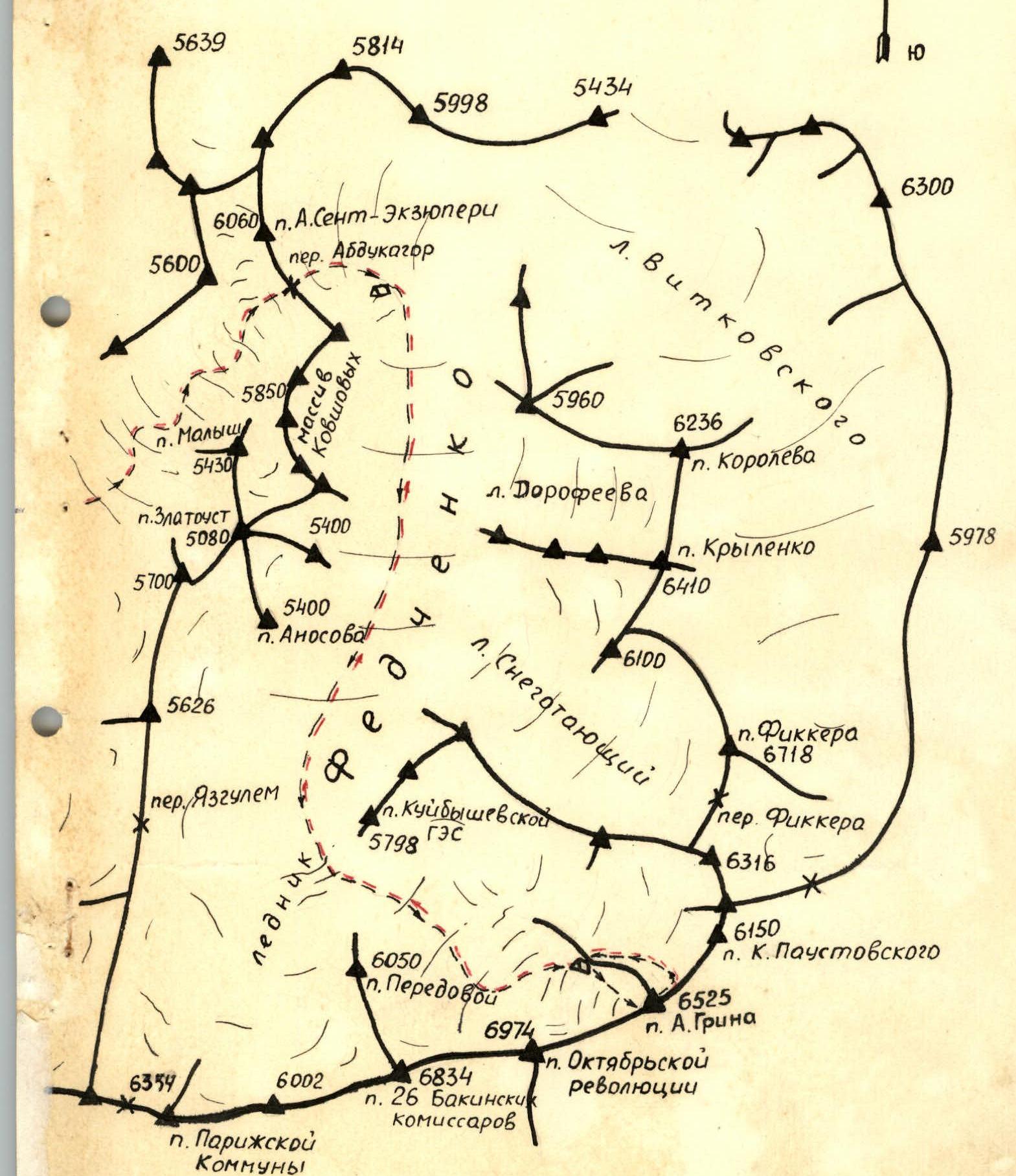
The peak of A. Grin (6525 m) is located in the Yazgulemsky ridge of the Central Pamir in the upper reaches of the Fedchenko Glacier, northeast of Peak Revolyutsii.
Fairly gentle ridges descend from the peak:
- to Peak Revolyutsii
- to Peak Omar Khayyam
To the northwest, towards the Fedchenko Glacier, a nearly sheer wall drops 1200 m, while to the southeast, towards the Grum-Grжимайло Glacier, very steep icy slopes descend.
The area is characterized by a harsh climate, large temperature fluctuations, significant snowfall, and unstable weather.
The upper reaches of the Fedchenko Glacier are difficult to access. Shuttle services typically begin from the tongue of the Abdukagor Glacier and take about two weeks. Prior to reaching the Abdukagor Pass (5070 m), all cargo was carried in backpacks.
After the pass, sleds were used, which were prepared in advance in Togliatti.
In addition to Peak A. Grin, the area is home to:
- Peak Revolyutsii (6974 m),
- Peak 26 Baku Commissars (6834 m),
- Peak Paris Commune,
- several other notable peaks.
These peaks have various routes, differing in:
- terrain type — rocky, snow-ice, combined,
- technical difficulty — from 3B category complexity and above, including routes of the highest category of difficulty.
The area features many interesting unattempted routes, one of which — the center of the Northwest wall on Peak Grin — was climbed by a team from the Kuibyshev Regional Council of the DSO "Trud".
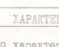
Table of Main Characteristics of the Ascent Route
The ascent route is via the southern spur of the western ridge of Peak A. Grin. The height difference of the route is 1250 m. Including the most difficult sections — 300 m. The steepness of the route is 30°. The steepness of the most difficult sections is 50°.
| Date | Section | Steepness | Length not distance | Characteristics of sections and conditions of passage by terrain type | by technical difficulty | by methods of overcoming and belaying | Pitons Rock | Ice | Time Out | Stops | Walking hours | Overnight conditions | Weather conditions |
|---|---|---|---|---|---|---|---|---|---|---|---|---|---|
| packed | |||||||||||||
| R0–R1 | 30° | 400 m | Icy slope, covered with firn | Easy 1B cat. diff. | Simultaneous movement, belaying through ice axe | 7:00 | 17:00 | 10 | Good | ||||
| R1–R2 | 45° | 200 m | Heavily destroyed rocks | Medium difficulty 4 | Belaying through ledges | ||||||||
| R2–R3 | 35° | 100 m | Icy ridge, with rocky outcrops | Difficult climbing 5 | Key belay | 5 | 4 | ||||||
| R3–R4 | 45° | 150 m | Icy salon | Difficult 5 | Key belay, cutting steps | ||||||||
| 29.07 | R4–R5 | 60° | 60 m | Heavily destroyed rocky wall | Very difficult, loose stones 5 | Key belay, first without backpack | 6 | 7 | |||||
| R5–R6 | 45° | 80 m | Heavily destroyed rocks | Difficult 5 | Key belay | 15 | 8 | ||||||
| R6–R7 | 40° | 40 m | Icy couloir with rocky outcrop, possible icefall from the ridge | Difficult and dangerous 5 | Key belay, cutting steps | 3 | 4 | ||||||
| R7–R8 | 80° | 20 m | Heavily destroyed rocky wall | Very difficult 5 | Key belay, first without backpack | 6 | Platforms on the ridge | ||||||
| R8–R9 | 30° | 200 m | Snowy ridge | Difficult 4 | Trenching, belaying through ice axe | ||||||||
| 30.07 | R9–R10 | 20° | 1000 m | Icy ridge, covered with firn | Easy 3 | Simultaneous movement, belaying through ice axe in dangerous places | 9:00 | 14:00 | 5 | Platform under the rocky wall | Wind, fog | ||
| 31.07 | R10–R11 | 15° | 700 m | Icy ridge, covered with firn | Easy 3 | Simultaneous movement | 9:00 | 13:00 | 4 | Wind, fog, occasional snow |
History of the Region's Exploration
The upper reaches of the Fedchenko Glacier were first explored in 1929. A group led by N. Krylenko, part of the Pamir-Tajik Expedition, arrived here. A group of German climbers, including Schneider, Wien, and Alens, also part of the same expedition, ascended a 6834 m peak later named Dorofeev Peak, or Peak 26 Baku Commissars, in September 1929 (see the expedition report).
In 1956, a team led by E. Kazakova re-explored this harsh and interesting region for climbers. The following year, a team under E. Tamm and V. Benkin, as part of the SAKN expedition, climbed Peak 26 Commissars and Peak Paris Commune (6354 m).
In 1960, participants from the same club conquered Peak Fickera (6718 m), Peak Krylenko (6419 m), Peak Omar Khayyam (6315 m), and Peak A. Grin (6525 m) via the Western ridge, led by V. Serebryakov.
The most challenging route in the area was pioneered in 1962 by a team led by L. Myshlyaev on Peak Revolyutsii (6974 m) via the North face.
The same route was repeated in 1967 by climbers from the Armed Forces (led by V. Nekrasov) and Chelyabinsk (led by A. Kuznetsov).
Chelyabinsk climbers from DSO "Trud" ascended many peaks in the area, including:
- repeating the ascent to Peak A. Grin via the Western ridge, category 4B complexity,
- undertaking a very interesting traverse from Peak Paris Commune to Peak A. Grin in 1964, led by V. Ryazanov.
Ascents to Peak Revolyutsii were made from the Grum-Grжимайло Glacier in 1954 (led by A. Ugarov) and 1960 (led by S. Savvon).
Complex routes were climbed from the Bartang valley by Soviet Army climbers on Peak Revolyutsii (teams led by V. Nekrasov and Artyukhin) and on Peak 26 Baku Commissars by climbers from Tomsk.
Team Composition and Preparation
Having chosen Peak A. Grin as the target, which was entered into the 1976 USSR Championship in the high-altitude technical climbing category, the coaching council formed a team of 7 members.
The team consisted of athletes from Togliatti, all representing DSO "Trud" and members of the alpinism sections of the Volga Automobile Factory and the Volga Cement Machinery Plant. Most team members developed within their sections, annually improving their skills through joint ascents. Kazayev Yu.V. and Statsky L.N. had been climbing together since 1968, undertaking ascents such as the traverse of Chapdara–Badkhona, Peak Engels via the southern wall, and Peak Khan-Tengri from the north.
In 1972, all team members (except Prokoshin) climbed Peak Kommunizma together. Years of joint training and ascents meant that team members knew each other's physical and technical capabilities, characters, and behavior in various conditions.
Preparation for the USSR Championship included training in sports halls and on the slopes of the Zhiguli Mountains. Various competitions and training sessions helped the team prepare well for the championship:
- Alpine biathlon (cross-country skiing and slalom)
- Rock climbing
- Regular training in sports halls
- Outdoor training
Simultaneously, the team prepared материально, manufacturing pitons, carabiners, and collapsible sleds at city enterprises. Significant effort was put into acquiring a "Karat" radio station for regular communication between the team on the route, the base camp, and the geologists' radio station in Khrustalny, as required by the regulations.
A supply of freeze-dried and scarce products was prepared in advance.
Team's Work in the Mountains and Tactical Ascent Plan
On July 10, 1976, the entire expedition (17 people) arrived in Khrustalny (2800 m) by car. The next day, all participants undertook a training ascent to the upper reaches of the Abdukagor valley, returning to Khrustalny.
On July 12, the teams conducted ice training on the Medvezhiy Glacier.
By July 15, all cargo was transported to the tongue of the Abdukagor Glacier by tractor.
After setting up a suspension crossing over the river, all cargo was transferred to the other bank, and shuttle services commenced.
The first intermediate camp, BNL, was established by a lake (3800 m). Shuttle services took three days.
The second intermediate camp was set up at the 5th section of the geologists, under the Abdukagor Pass (4200 m). Here, after thoroughly sorting the cargo and resting for a day, they began transporting goods to the pass (5070 m), from where they continued along the Fedchenko Glacier using sleds.
By the morning of July 26, all expedition members were at the assault camp (Myshlyaev's camp, 5200 m).
On July 26–27, the entire team, along with coach V.S. Benkin, surveyed the wall, observing it throughout these days. They finally chose the route up the center of the Northwest wall, considering it the safest, most logical, and interesting in terms of sporting challenge. The right and left variants were deemed more rockfall-prone and less interesting.
Initially, the left variant up the black bastions was considered, assuming the center might be impassable without extensive use of bolt pitons, and that much of the lower wall appeared overhanging. However, upon closer inspection, the center of the wall was deemed passable.
After two days of observation, it was decided to ascend in a team of six:
- Statsky L.N. — captain
- Sharov O.Ya. — deputy captain
- Kazayev Yu.V. — member
- Pshenichnikov A.A. — member
- Mavrin B.M. — member
- Prokoshin G.I. — member
July 28. The team processed the lower part of the wall. A 80 m rocky outcrop was bypassed on the left via a steep (60°) icy slope covered with a thin layer of snow. Two ice pitons and four rock pitons were hammered. Boris Mavrin led the section on crampons.
After advancing 90 m, they reached a rocky wall, which was ascended via a steep (70°) ledge to the right, then left to an inclined platform. After 60 m, six rock pitons were hammered. A vertical wall was then encountered, ascended via a steep (80°) crack to the right, followed by a four-meter wall — a leftward exit to individual vertical and negative walls.
Switching from crampons to Vibram boots, Oleg Sharov, the team's best rock climber, led this section. Ladder use was necessary. Very difficult climbing.
Finally, this section was behind them. 70 m were covered, 15 pitons were hammered, with an average steepness of 85°. 220 m of rope were fixed that day.
They descended to the base camp.
July 29. The team returned to the wall, following the fixed ropes. The ropes were inspected, and all were intact.
Further processing continued. The path went up a wall with an average steepness of 75°, featuring small (2–3 m) vertical rock sections.
The wall was intersected by two couloirs. The rocks were smooth, with few handholds or cracks for pitons.
Climbing was difficult. Arkaдий Pshenichnikov led in Vibram boots. 120 m were covered, with 11 pitons hammered.
After lunch, the weather began to deteriorate:
- fog rolled in,
- snow started falling.
Processing was halted, and they quickly descended.
July 30–31. The weather was poor, with snow and fog. They analyzed the processing, planning the tactical ascent. As only one potential campsite was identified on the lower wall — under the "Bastion", 100 m ahead — they planned to follow the fixed ropes on the first day and reach the proposed campsite.
On the second day, they would process the "Bastion" to the start of the "Sickle" and camp at the old site. On the third day, they would ascend with loads to the start of the "Sickle" and camp there. On the fourth day, they would climb the "Sickle" to the rocky triangle and camp beneath it.
On the fifth day, they would reach the pre-summit rocky wall. On the sixth day, they would ascend via the couloir to the pre-summit ridge and then to the summit.
On the seventh day, they would descend to the base camp. The team was equipped with a "Karat" radio for communication with the base camp. In case of radio failure, they had flares.
During the ascent, the team was monitored by an observation group. Additionally, the base camp housed:
- the coach,
- the head of rescue,
- the remaining expedition members.
The control deadline was set for 12:00 on August 2.
Processing the wall revealed the structure of the rocks, with many wide cracks — they took more channel irons and wedges.
August 1–2. The weather was good. They waited for the upper sections to clear of avalanches and for some snow to melt off the rocks. They prepared for departure, checking gear and supplies, and trained on nearby rocks.
Ascent Diary
August 3. At 8:00, they left the base camp. It was cold, with hard snow. They moved quickly to warm up.
By 9:00, they were under the wall, crossing the bergschrund and beginning the ascent via the fixed ropes. The ropes, hung for four days, were inspected and found to be intact.
With backpacks, progress was slow. The first 150 m were climbed with packs on. It was hard, and hands were freezing — snow hadn't melted everywhere.
Before the wall — section R3 — they removed their backpacks. The duo, Sharov and Pshenichnikov, went ahead to process the route further to the proposed campsite, taking the removed ropes (40 m and 70 m). The remaining four began hauling the backpacks up the sheer wall.
Progress was slow due to the lack of a good standing position and a place to stack the backpacks (they were hung on pitons).
They caught up with the gear and supplies abandoned during processing, reloading their backpacks. Sharov and Pshenichnikov had processed another 100 m of the route (9 pitons hammered) and were cutting platforms for tents. Finally, they reached this point. The situation wasn't ideal — a sharp snow-ice ridge. They cut two small platforms for two tents, accommodating three people each.
Prokoshin G. and Mavrin B. retrieved the remaining ropes.
By 21:00, they finished setting up the tents. It was cramped. They lay down, tied to the main rope running through the tents. Lights out at 22:00.
August 4. According to the tactical plan, they were to process the further route up the wall — to the "Sickle". They took:
- all spare ropes
- the "forge" (equipment)
- crampons
- some food and fuel
They ascended via rusty, smooth rocks — 15 m, then traversed left and up into a snow-ice couloir, and up under the "Bastion" wall, which led to the start of the "Sickle".
Climbing was very difficult, with frequent changes of leads. It was cold; the sun hit the wall around 2 pm.
The "Bastion" wall featured steep rocks with individual vertical sections (3–4 m), partially iced. Monolithic rocks required various pitons.
The sun appeared, but clouds gathered. A quick snack, and they continued up.
By 5 pm, it was foggy, and snow started falling. They were about 70 m short of the "Sickle". They left their gear on the last pitons and descended to the tents.
Snow fell intermittently throughout the night. The night was uncomfortable. The tents were battered by wind and snow.
August 5. The morning was foggy, with wind dying down, and snow falling. This continued throughout the day. The wall was white. Avalanches roared down nearby couloirs. By evening, the fog cleared, and snowfall stopped. They spent the day in the tents. The night was calm.
August 6. They set out at 9 am. The goal was to reach the start of the "Sickle", where a campsite was planned.
Attempting to ascend via the fixed ropes with backpacks proved too difficult; they removed their packs.
The duo, Kazayev Yu. and Pshenichnikov A., went ahead without backpacks to further process the route under the "Sickle". The remaining four started hauling the backpacks. It was hard work, very cold, with frequent hand rubbing. Feet were freezing due to snow on the ledges. The weather was good. The sun appeared around 2 pm, warming things up.
Kazayev and Pshenichnikov returned, having:
- fixed 70 m of rope
- reached the "Sickle"
They searched for campsites along the "Sickle" for another 60 m but found none. The "Sickle" offered a problematic campsite — a sharp ice ridge where only one platform for a sitting overnight stay could be cut. At 20:00, they set up the tent and contacted the base camp. The weather was good. Morale was high, having passed the most technically challenging part of the wall. They left a control note in a tin can in a small rocky niche. The night was relatively calm, though they didn't sleep well.
August 7. At 9 am, they began moving along the "Sickle" ridge. The ridge was icy, covered with a thin layer of snow, with outcrops of destroyed rocks. The average steepness was around 50–60°. They wore crampons, cut steps, and began to feel the altitude — after a few swings of the ice axe, they were short of breath. Belaying was through ice and rock pitons hammered into rock outcrops. The ridge remained steep and snow-ice throughout, with no place to gather. Each had a sabza (dried fruit) and candies in their pockets for snacks.
They aimed to maximize daylight — the weather was good. They approached the "Black Gendarme", where a campsite was planned. However, suitable sites were lacking. They had to ascend the "Black Gendarme" — a 40-meter wall, 75° steep. The slope was heavily destroyed. Oleg Sharov led without a backpack, fixing 40 m of rope. Then, everyone ascended via the fixed ropes, carefully, as there was little protection below. They hoped to find a campsite above but were disappointed. The ice ridge turned into a cornice. They cut two small platforms on this ridge and cornice for two tents, accommodating three people each. At 22:00, they set up the tents. The overnight stay was decent, almost lying down. They tied themselves to the main rope through the tents and quickly fell asleep. The night was calm.
August 8. They departed at 8:30 am, planning to reach the summit. They covered 110 m along the snow-ice cornice on the ridge, 55° steep. The ridge turned left. They descended right into a wide snow-ice couloir leading directly under the summit. The steepness gradually decreased.
By 2 pm, they approached the "Black Wall", where a campsite was planned. With plenty of daylight remaining and good weather, they continued. The summit seemed close.
Belaying was through:
- ice pitons,
- rock pitons hammered into nearby rock walls.
Movement was:
- with frequent changes of leads,
- alternating.
The couloir ended at a rocky outcrop, followed by a snowy slope turning into a heavily destroyed wide rocky ridge at the top. Here, they left their backpacks and ascended 30 m up the ridge to the summit at 17:30.
They retrieved a note left by V. Ryazanov's team from Chelyabinsk (1964), left their own, took photos, and began descending the Northwest ridge. By 19:30, they reached a wide depression. Finally, they could rest properly. They set up tents. The night was calm, though very cold.
The next day, they continued descending the ridge and reached the base camp by 11:30 am.
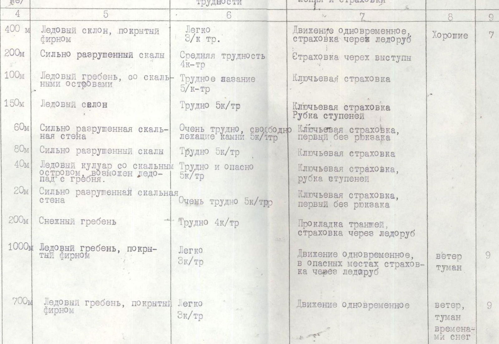
Table of Main Characteristics of the Ascent to Peak A. Grin via the Center of the Northwest Wall
Height difference: 1200 m. Average steepness. Time to ascend: 45 h 5 min (excluding processing).
| Date | Section Number | Length of Section in Meters | Average Steepness | Characteristics by Terrain Type | By Technical Difficulty | Category of Difficulty | By Method of Overcoming and Belaying | Pitons Rock | Ice | Time Out | Stops | Walking Hours | Overnight Conditions | Weather Conditions |
|---|---|---|---|---|---|---|---|---|---|---|---|---|---|---|
| 3.08.1976 г. | R1 | 90 m | 63° | Icy slope, dusted with thin layer of snow | Steep slope | 5 | Alternating movement, belaying through pitons | 4 | 2 | 9:30 | 18:30 | 9 | Satisfactory overnight stay | Good |
| R2 | 60 m | 70° | Rocky wall | Difficult climbing | 5 | — | 6 | — | ||||||
| R3 | 70 m | 85° | Rocky wall with individual vertical sections up to 3–4 meters | Very complex climbing, using ladders | 6 | Movement on fixed ropes. Piton belay. Hauling backpacks. | 15 | — | ||||||
| R4 | 120 m | 75° | Rocky wall with individual steep sections up to 2–3 meters. Rocks smoothed. | Complex climbing | 5 | — | 10 | |||||||
| R5 | 100 m | 75° | Rocky wall. Rocks heavily smoothed. Some areas iced. | Complex climbing | 5 | Movement on fixed ropes. Piton belay. Hauling backpacks. | 8 | |||||||
| 4.08.1976 г. | 9:00 | 17:00 | 8 | Overnight stay at old site | Weather deteriorated in the second half of the day — fog, snow | |||||||||
| 5.08.1976 г. | Bad weather — snow, fog | |||||||||||||
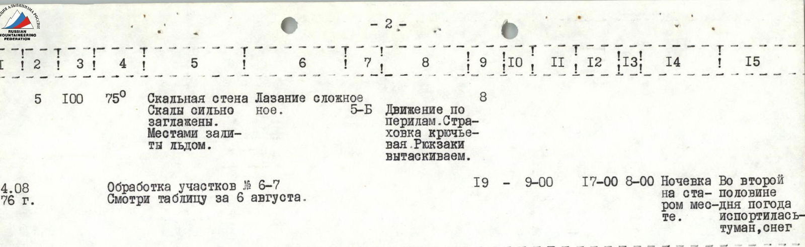
| 6.08.1976 г. | R6 | 60 m | 75° | Rocky wall "Bastion". Rocks smoothed. | Difficult climbing | 5 | Movement on fixed ropes. Hauling backpacks. | 6 | — | 9:00 | 19:30 | 10 | Sitting overnight stay in one tent | Good |
| R7 | 110 m | 80° | Rocky wall "Bastion". Individual steep sections iced. | Very difficult climbing | 6 | Piton belay | 13 | |||||||
| R8 | 70 m | 75° | Rocky wall "Bastion". Rocks snow-covered. | Difficult climbing | 5 | Movement on fixed ropes | 7 | |||||||
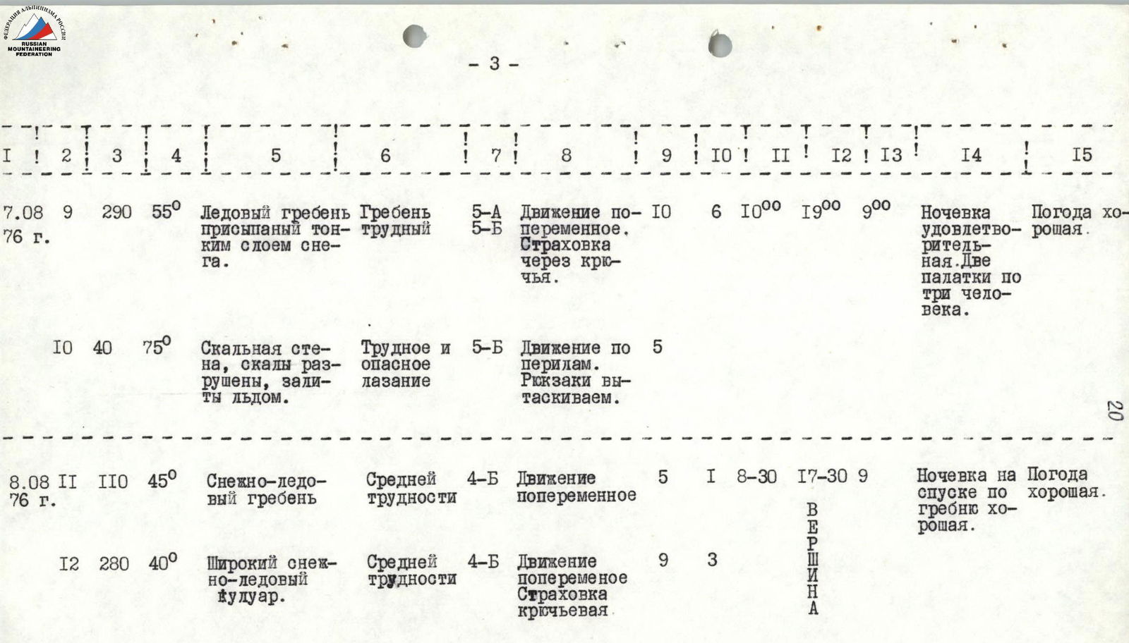
| 7.08.1976 г. | R9 | 290 m | 55° | Icy ridge, dusted with thin layer of snow | Difficult ridge | 5 | Alternating movement. Belaying through pitons | 10 | 6 | 10:00 | 19:00 | 9 | Satisfactory overnight stay. Two tents for three people | Good |
| R10 | 40 m | 75° | Rocky wall, rocks destroyed, iced. | Difficult and dangerous climbing | 5 | Movement on fixed ropes. Hauling backpacks. | 5 | |||||||
| 8.08.1976 г. | R11 | 110 m | 45° | Snow-ice ridge | Medium difficulty | 4 | Alternating movement | 5 | 1 | 8:30 | 17:30 | 9 | Good overnight stay on descent along the ridge | Good |
| R12 | 280 m | 40° | Wide snow-ice couloir | Medium difficulty | 4 | Alternating movement. Piton belay. | 9 | 3 |


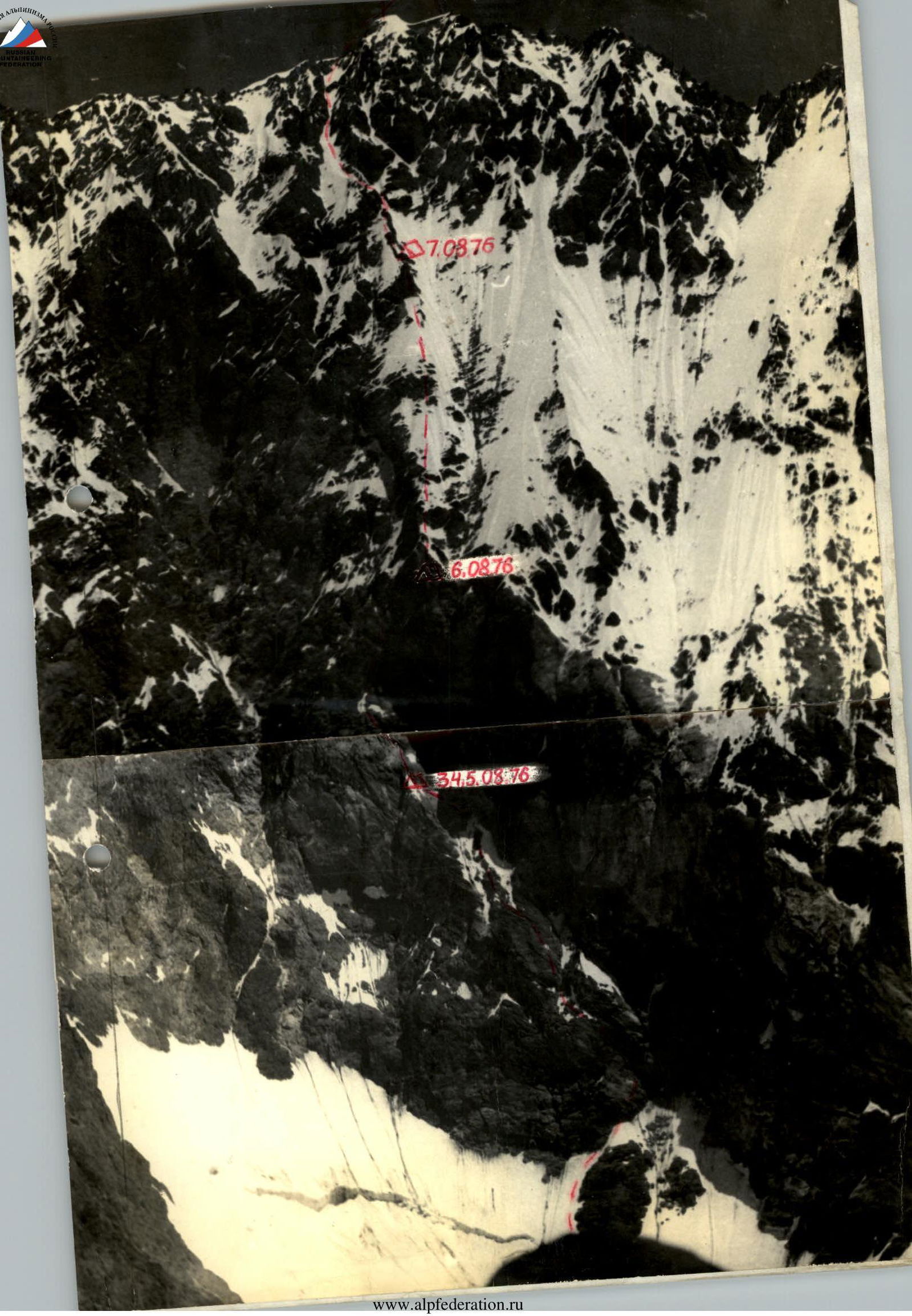
Brief Description of the Route
Directly up the center of the wall is a rocky outcrop in the lower section. To reach it, a steep (60°) icy ascent is made, bypassing the outcrop on the left (right is rockfall-prone!). Belaying is through pitons — rock and ice. Along a rocky ledge, up to the right, then left under a vertical wall — difficult rocks.
The vertical wall is ascended to the right, steeply up, then left — through a series of steep rock sections.
These sections are climbed using ladders, with thorough piton belaying, and very complex climbing. The exit is onto a steep (75°) wall, intersected by two grey couloirs. Climbing continues left and up, crossing both couloirs, with smoothed rocks and piton belaying. The route leads under the "Bastion" — here is a campsite, on a narrow icy ridge where two small platforms can be cut. No campsites are visible before this point.
From the campsite, the route goes left and up via rusty rocks, bypassing the "Bastion" for 60 m, then up a complex ice couloir for 20 m, and directly up the "Bastion" wall for 180 m (average steepness 80°). The "Bastion" is a rocky wall with individual vertical sections, iced and snow-dusted. Climbing is very complex. Belaying is through pitons, with movement on fixed ropes. The upper section involves a rightward exit and a move onto the "Sickle". Here, a small platform for one tent can be cut. A control cairn is left in a rocky niche. The "Sickle" is ascended directly. It's an icy ridge, dusted with snow, with an average steepness of 50–60°, featuring outcrops of destroyed rocks. Belaying is through ice pitons hammered into rock outcrops. Channel irons are used effectively.
Brief Description of the Route (Continued)
Further ascent follows the ridge to the "Black Gendarme", a rocky wall towering above the ridge, with destroyed rocks, iced, and snow-dusted.
On the gendarme, two small platforms for two tents can be cut.
Along the gendarme's ridge (right are cornices!) for 110 m, then a slight descent to the right into a couloir leading directly under the summit. The couloir is snow-ice — snow lies in a thin layer.
In the upper part of the couloir is a rocky outcrop, bypassed on the left; beyond it is a wide, gentle slope (30°) — firn with rock outcrops. The route continues directly up to the pre-summit ridge.
Along the ridge, rightward up (30 m) to the summit. Descent is via the Northwest ridge, category 4B complexity.
Map of the upper reaches of the Fedchenko Glacier area