MOSCOW REGIONAL COUNCIL Sports Society "Zenit" Protocol No. 322 dated November 24, 1970 4A — first ascent Peak 5398 "Army Men". via the Southwest wall (Central Pamir)
1970
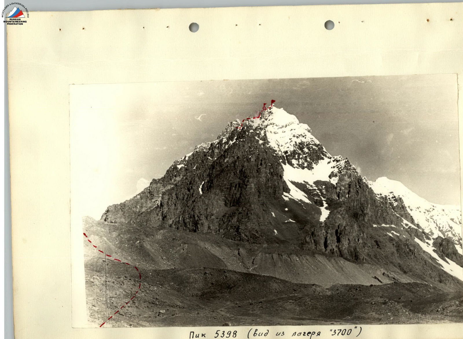
Peak 5398 (view from camp "3700")
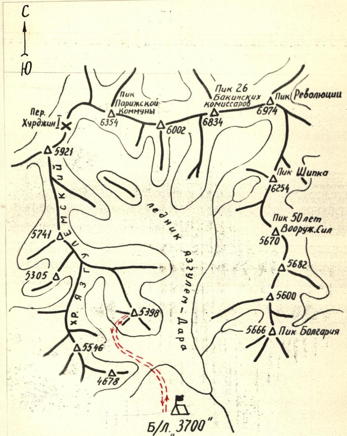
Map of the area
Geographical Location
The gathering place for the climbers of the Moscow Regional Council of the Sports Society "Zenit" in 1970 was the area of Peak Revolyutsii in the Central Pamir, with the base camp located in the upper reaches of the Yazgulem-Dara valley.
Peak 5398 belongs to one of the spurs of the Yazgulemsky ridge on the western side of the valley.
On the opposite, eastern side of the valley, from north to south from Peak Revolyutsii, stretch peaks exceeding 5000 m. Above them rises Peak Shipka – 6254 m.
The entire area is dominated by six-thousander peaks located in the northern part of the valley:
- Peak Revolyutsii,
- Peak 26 Baku Commissars,
- Peak Paris Commune,
on the southern slopes of which the Yazgulem-Dara glacier originates, and on the northern slopes – one of the largest glaciers in the world, the Fedchenko glacier.
Climbing Conditions
The remoteness (over 100 km) from large settlements and highways significantly complicates the organization of expeditions to this area.
Only in 1967 did the first climbing expedition of athletes from CSKA arrive here. The expedition obtained a lot of interesting data – photographs, aerial photographs; made several first ascents:
- on Peak Shipka,
- Peak Bolgariya,
- and others.
The area is characterized by a large difference in altitude, up to 3 or more kilometers, steep slopes, and the possibility of choosing the most complex routes that have never been taken before. Climatic conditions are quite favorable. In the summer months – July, August – fairly stable, clear weather is observed here. However, at an altitude of about 6000 m, the wind almost never subsides, reaching 10–15 m/s, and the temperature drops to –20°C at night.
Preparation for the Ascent
The team of climbers from the Moscow Regional Council of the Sports Society "Zenit" together with the combined team of the Central Council of the Sports Society "Zenit" arrived in the district center Rushan on July 4. The delivery of goods and people to the location of the base camp was carried out from the Rushan airfield by helicopter, which saved us from the need to equip a slow-moving and bulky caravan. On July 7, all work on organizing the base camp on a large flat green area at the tongue of the Yazgulem-Dara glacier, at an altitude of 3700 m, was completed.
Reconnaissance exits and training ascents were planned to study as large an area as possible and choose the most interesting routes for ascents. In addition, training ascents gave the athletes the opportunity to acclimatize at high altitudes.
On July 9, the entire expedition made an exit to scout the path through the glacier and approaches to the peaks in the area:
- Peak Paris Commune,
- Peak Revolyutsii,
- and Peak Shipka.
Two days later, a group of 5 people, including team members Kuzmin and Tyurin, set out to ascend Peak 4678.
In addition to training purposes, the group was tasked with making a preliminary reconnaissance of the area of Peak Lyap-Nazar (5988) – one of the notable peaks in the valley. At the same time, another group of 6 people, which included team members Vorobyov and Pugachev, went to the rocky massif ("Grebionka") in the ridge of Peak 5600 on the opposite side of the valley from the camp. From here, from "Grebionka" (5000), the further path to Peak 5600, located between Peak 5682 and Peak Bolgariya, was observed, as well as the never-before-taken southwest ridge of Peak Shipka.
On July 14, a group of 4 people ascended Peak Bolgariya (5666) via Peak 5600. A day later, on July 15, a second group of 6 people followed the same route. The team members Pugachev, Kuzmin, Vorobyov, and Tyurin were part of these groups. The ascent lasted 5 days. From Peak 5600, the saddle leading to the base of the wall of Peak 5682, characterized by its sharp outlines, a peak still unconquered by climbers, was observed.
On July 21, Pugachev and Vorobyov ascended to the cirque where Peak 5398 is located, examined the approaches to it, and clarified the ascent route.
The following team composition was approved for the ascent:
- Pugachev V.A. – II sports category, leader;
- Kuzmin A.S. – II sports category, participant;
- Vorobyov L.F. – II sports category, participant;
- Tyurin G.S. – II sports category, participant.
Based on the results of the route reconnaissance, organizational and tactical plans for the ascent were developed.
Organization of the Ascent
Taking into account the peculiarities of the route – the presence of snow-ice and rock wall sections, we selected, in addition to standard equipment:
- titanium rock pitons (20 pcs.);
- ice pitons (4 screw and 6 tubular);
- titanium crampons (2 pairs);
- protective helmets.
The group took one tent – a Pamirka. The amount of food was calculated at 750 g of dry rations per person per day for 3 days on the route.
For communication with the base camp, a portable radio station was taken, and communication sessions were scheduled:
- 9:00;
- 17:00.
Emergency communication:
- 12:00;
- 21:00.
The control time for returning to the camp was set for July 26, 1953, at 18:00.
Observation of the ascent was carried out directly from the camp.
The entire route was divided into main sections, and bivouac locations were designated. It was assumed that the key section of the route is the wall in front of the peak.
Order of Passage of the Route
1st day. On July 22, at 16:00, the group left the base camp "3700", ascended the moraine, to the left, into the cirque formed by the peaks of the Yazgulemsky ridge and its spur, where Peak 5398 is located. Along the moraine ridges, we cross the glacier in the direction of the long snow couloir, along which the ascent is planned. Not reaching the couloir, we set up a site for an overnight stay. It took 2 hours and 30 minutes to cover the path from camp "3700" to the lower overnight stay (R0–R1).
2nd day. On July 23, at 6:30, the group set out on the route. A lot of snow fell overnight, but the weather improved by morning. The lower part of the couloir (20°, 400 m) (R1–R2) is traversed simultaneously by teams Vorobyov — Tyurin and Pugachev — Kuzmin. As the steepness of the couloir increases (30°, 600 m) (R2–R3), sections of ice appear in places, which are overcome with alternate belay via pitons and ice axe with step cutting. The steepness of the couloir continues to increase as we move forward and reaches 40°–50° (R3–R4). We head towards the rocky outcrops in the middle part of the couloir, which we bypass to the left. We move slowly, kicking steps in the snow. The teams and lead climbers frequently change places. Ahead is a wall. To the left of it is a couloir with traces of avalanches. It is very steep, and movement along it is extremely dangerous – hanging cornices are visible at the top. To the right of the wall is a sharp rocky ridge with unstable snow cornices. The most logical and relatively safe path is along the wall. At 14:00, we begin the ascent along the heavily destroyed rocks. It is difficult to find places for pitons. Many "live" stones. The first ascent (70°, 20 m) (R4–R5) is overcome by very complex climbing. Belay via ledges and pitons. We reach a small snow ledge. The second ascent (R5–R6), with a steepness of 80°, is bypassed to the right along the boundary of rocks and snow slightly covering the ice. Movement is alternate with belay via ledges, pitons, and step cutting. The third ascent (60°, 120 m) (R6–R7) is overcome by complex climbing along unstable rocks of slab structure, which lead us to a snow mulde under the peak (R7–R8). Here, at 19:00, we set up an overnight stay. 3rd day. On July 24, at 7:00, we head towards the peak with a huge snow cornice hanging over the eastern slope. Along the peak rocks (80°, 6 m) (R8–R9), we reach the snow-free southern rocky shoulder of the peak and at 8:00, we build a cairn, leaving our note in it. We propose to name the peak "Peak Dubna". After admiring the beautiful panorama of the surrounding mountains, many of which are still waiting for their first ascenders, we began our descent. The descent followed the ascent route and took 3 hours and 30 minutes to reach the lower overnight stay.
Overall Assessment of the Participants' Actions
The team is well physically prepared. The participants are proficient in the technique of movement on snow, ice, and rocks, skillfully navigate the route, and are tactically competent. Despite the complexity of the route (destroyed rocks, ice, etc.), the team members always found opportunities to organize reliable belay. Preliminary acclimatization at high altitudes ensured the group's efficiency when passing complex wall sections at an altitude of over 5000 m.
Conclusion
The route to Peak 5398 via the southwest wall is combined, rock-snow-ice. The length of the route is 2.1 km (to the peak). The total ascent is 1700 m, with the most complex sections being 150 m. The route corresponds to category 4B difficulty. Team leader (signature) (Pugachev V.A.) Participants (signature) (Kuzmin A.S.) (signature) (Vorobyov L.F.) (signature) (Tyurin G.S.)
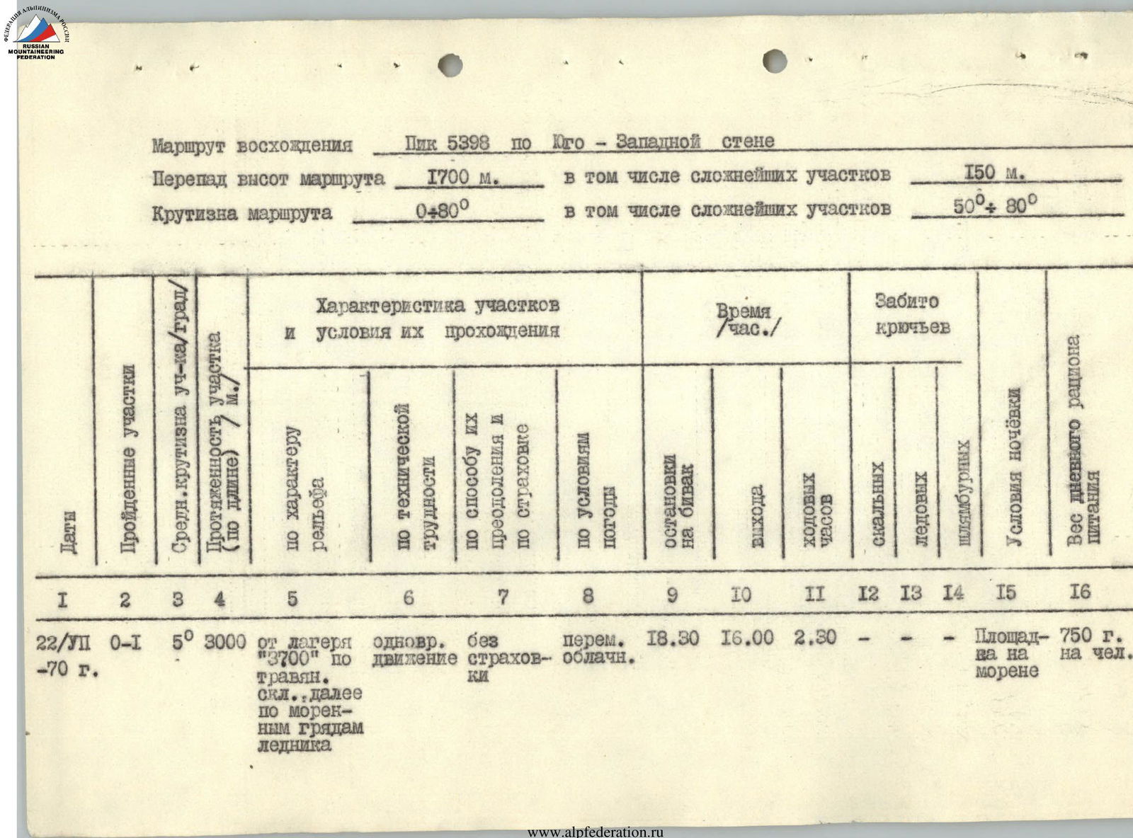
Ascent Route
Peak 5398 via the Southwest wall Route elevation gain: 1700 m, including the most complex sections: 150 m. Route steepness: 480°, including the most complex sections: 50°–80°.
| Date | Sections traversed | Average steepness of section (degrees) | Section length (m) | Characteristics of sections and conditions of their passage: by terrain character | by technical difficulty | by method of overcoming and belay | by weather conditions | Bivouac stops | Time (h): departure | walking hours | Pitons used: rock | ice | tubular | Bivouac conditions | Daily food ration weight |
|---|---|---|---|---|---|---|---|---|---|---|---|---|---|---|---|
| 1 | 2 | 3 | 4 | 5 | 6 | 7 | 8 | 9 | 10 | 11 | 12 | 13 | 14 | 15 | 16 |
| July 22 | R0–R1 | 5° | 3000 m | from camp "3700" along grassy slopes, then along moraine ridges of the glacier | simultaneous | without belay | variable cloudiness | 18:30 | 16:00 | 2:30 | – | – | – | Moraine site | 750 g per person |
| July 23 | R1–R2 | 20° | 400 m | snow couloir | easy section | simultaneous belay | – | – | 6:30 | – | – | – | – | – | – |
| R2–R3 | 30° | 600 m | snow-ice couloir | easy section, местами средней трудн. | in places with exposed ice, alternate belay via pitons and ice axe | – | – | – | – | – | 2 | – | – | – | |
| R3–R4 | 40°–50° | 800 m | snow-ice couloir | medium difficulty | – | – | – | – | – | – | 2 | – | – | – | |
| R4–R5 | 70° | 20 m | heavily destroyed rocks | very complex climbing | alternate belay via ledges and pitons | – | – | – | – | 3 | – | – | – | – | |
| R5–R6 | 40° | 100 m | along the boundary of solid rocks (80°) and snow with ice | medium difficulty | alternate belay via ledges, pitons, and ice axe; step cutting | – | – | – | – | 4 | – | – | – | – | |
| July 24 | R6–R7 | 60° | 120 m | unstable rocks of slab structure | complex climbing | alternate belay via ledges and pitons | – | 19:00 | – | 12:30 | 8 | – | – | snow mulde before the peak | 600 g per person |
| R7–R8 | 20° | 80 m | snow mulde | easy section | simultaneous belay | – | – | 7:00 | – | – | – | – | – | – | |
| R8–R9 | 80° | 6 m | unstable rocks (peak) | complex climbing | alternate belay via ledge and piton | – | – | – | 1:00 | 1 | – | – | – | – | |
| R9–R10 | descent along the ascent route | – | – | – | – | – | – | – | 3:30 | – | – | – | – | – | |
| Total: | 17:00 (without approaches) | 16 (during ascent) |