
PASSPORT
- Class — high-altitude technical
- South-West Pamir, Shakhdarin Range
- Peak named after S. Darius and S. Girėnas (5998.3 m) via the northern ridge
- Proposed — 5A category of difficulty, combined, first ascent
- Elevation gain — 1198 m, length — 2310 m
Length of sections 6 — 28 m, 4–5 — 400 m. Average steepness of main sections 70°.
- Pitons driven
| rock | placements | ice |
|---|---|---|
| 45 | 17/2 | 17/0 |
- Team's climbing hours: 17.5 h
- Overnight stays: one (on an artificial platform)
- Team leader: Vasily Ignatyevich Melentyev, Master of Sports Team members: Eugenijus Petрович Klikunas, 2nd sports category; Arvydas Antanovich Avulis, 2nd sports category; Kęstutis Kazевич Baleišis, 2nd sports category.
- Coach: Mikhail Aleksandrovich Plyševsky, 2nd sports category
- Start of the route — 6:00 August 7, 1984. Summit — 11:00 August 8, 1984. Return — 15:00 August 8, 1984.
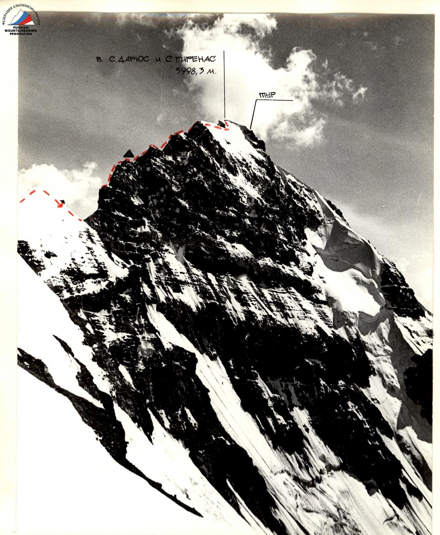
Fig.1. General view of the summit. A — overnight stay on August 7, 1984. Photo from the S-E slope of the S-W spur of peak 6004 m (5200). August 5, 1984, distance 1.5 km. Lens INDUSTAR 50–2.
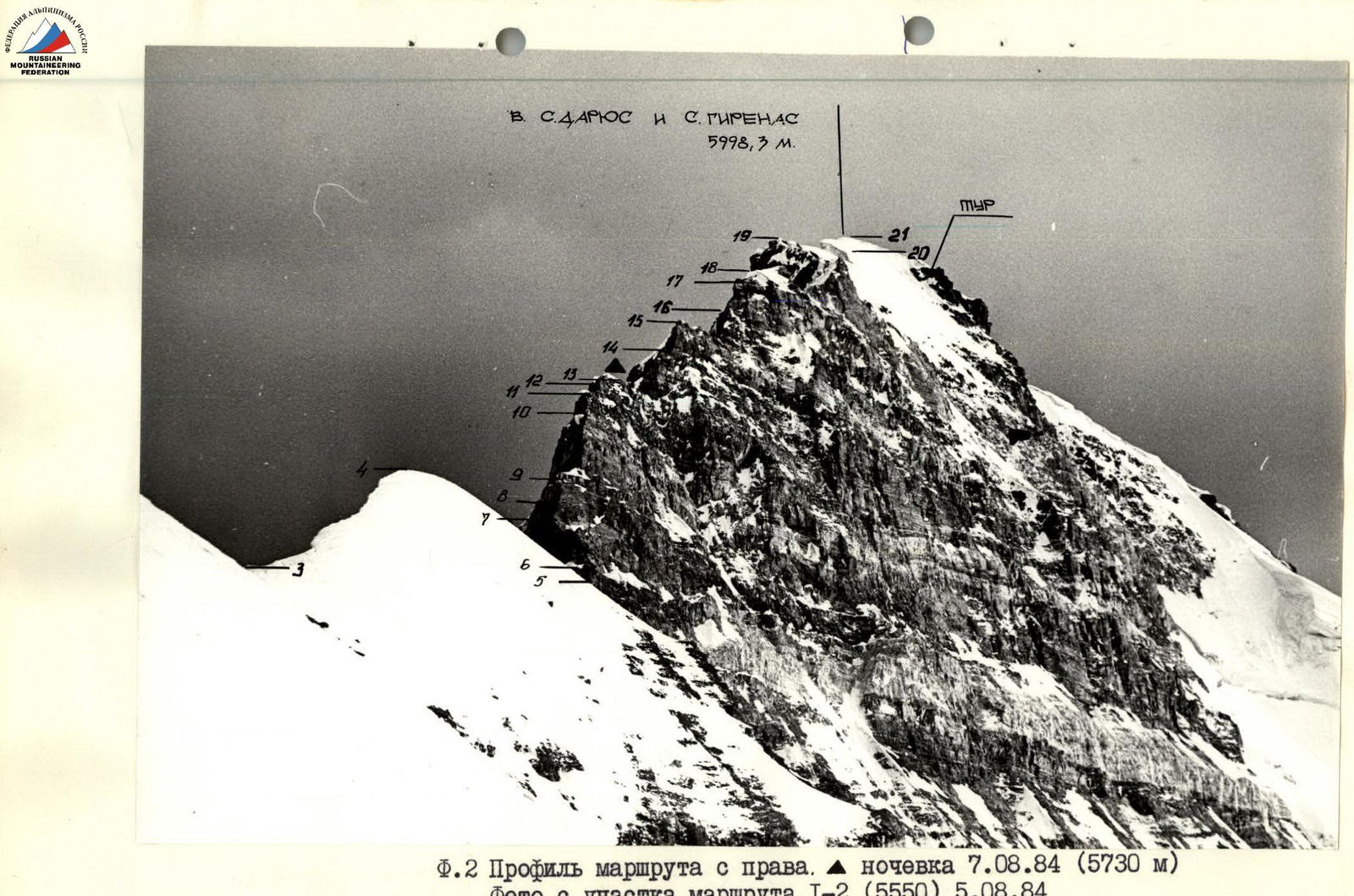
Fig.2. Profile of the route on the right. Overnight stay on August 7, 1984 (5730 m). Photo from section R1–R2 (5550) on August 5, 1984. Lens INDUSTAR 50–2.
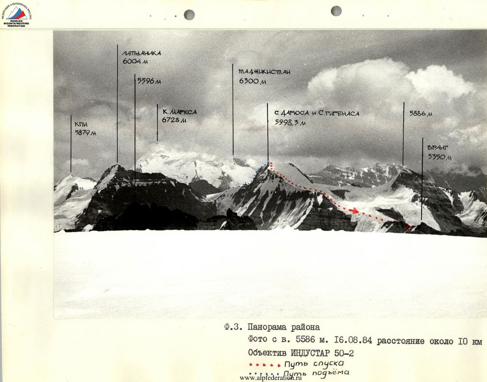
Fig.3. Panorama of the area. Photo from peak 5586 m on August 16, 1984, distance about 10 km. Lens INDUSTAR 50–2.
Brief overview of the climbing area
Peaks 5350 m (Vrang), 5998.3 m (S. Darius and S. Girėnas), 6004 m (Lituanica), 5879 m (KPI), 5649 m (Academician K. Baršauskas) are located in the South-West Pamir, in the eastern part of the latitudinal section of the Shakhdarin Range.
The nearest areas explored by climbers are the areas of peak K. Marx (6728 m) and peak F. Engels (6550 m) to the east, and the areas of peaks 6138 m (Armed Forces) and 6058 m (Baikonur) to the west.
Traveling through the Pamir in 1904, B.A. Fedchenko explored and described the area of the Shakhdarin Range, located between the Shakhdara and Panj rivers.
Climbing exploration of the Shakhdarin Range began in 1946. In that year, peak K. Marx was conquered. In subsequent years, a number of expeditions were organized, mainly to the area of peaks K. Marx and F. Engels. The central part of the Shakhdarin Range began to be explored in 1974. In 1975, an expedition of the Armed Forces led by Nekrasov V.P. conquered peak 5800 m via a route of 5B category of difficulty along the N-W edge. This peak was named Luknitsky. In subsequent years, military climbers, as well as other climbing expeditions, completed a number of interesting routes of 5B and 6B categories of difficulty in this area, becoming prize-winners of the USSR Climbing Championship.
However, part of the Shakhdarin Range (southern spurs, west of peak K. Marx) remained unknown to climbers. In 1983, the Sports Committee of the Lithuanian SSR organized a reconnaissance trip to this area, and in the summer of 1984, an expedition of the Sports Committee of the Lithuanian SSR led by Gudyalis A.V. arrived at the Vnukut river gorge with the goal of studying the area, conquering several peaks, and naming them. The base camp was set up at the confluence of the Vnukut and Chondzhirav rivers, at an altitude of 3520 m, approximately 3 hours' walk from the village of Vrang.
From a climbing perspective, the area is very interesting for climbers from 2nd sports category to Candidate Master of Sports. There are many routes to the summits ranging from 3rd to 5th category of difficulty. Many rock, mainly combined routes (including several snow and ice routes). Approaches to the routes take 3–8 hours from the base camp. Many first ascents are possible. Rivers are turbulent. In the second half of the day, they are difficult to cross. Weather is stable. Vegetation is very scarce, with practically no trees.
Tactical actions of the team
The group departed from the initial bivouac on August 7, 1984, at 6:00. Snow and ice sections # 3–5, 10–22 were traversed by the group with piton protection and changing leads. Rocky sections were first traversed by Baleišis K. with a lightened backpack. Some sections: # 5–12 — in icy conditions. Other team members traversed complex sections # 6–7; 7–9; 10–12; 14–15; 16–17, with the aid of fixed ropes.
On August 7, 1984, at 16:00, the weather began to deteriorate, snow started falling, and a thunderstorm began. At 19:00, the group, having descended 20 m below the ridge, spent 3 hours carving out a 4-person platform and set up for the night.
At 7:00 on August 8, 1984, the group continued on the route and, under normal weather conditions, reached the summit at 11:00.
The ascent to the summit took 17.5 hours. The descent from the summit was made to the southwest across snow fields, towards peak Vrang (5350 m). Then along the northwest scree ridge directly to the initial bivouac.
5998.3 m
Description of the route by sections
The initial bivouac for the route is located on the right bank of the Chondzhirav river, 700 m below the confluence of the rivers from the cirque glaciers of peaks 6004 m, 5879 m, 5223 m, and the cirque of peaks 6004 m and 5998 m.
Section R0–R1 — this is the exit to the glacier cirque towards 6004 m and 5998 m. Crossing the glacier presents no major difficulties, although the middle part of the glacier is closed, with large crevices.
R1–R2 — this is an ascent to the ridge, 200 m to the right of the saddle between peaks 6004 m and 5998 m. Steepness of the ascent is 30°–45°. Elevation gain is 850 m (counting from the bivouac) and takes 3–4 hours of pure climbing time.
R2–R4 — along the snow and ice ridge, whose steepness increases from 30° to 60° (piton protection, beware of cornices on the eastern side of the ridge).
R4–R5 — descent into a rocky pit. Rocks are crumbling, climbing is straightforward.
R5–R6 — the ridge overhangs with a 30-meter negative wall, which is bypassed on the left (in the direction of travel) for 50 m along a scree ledge to black, sweeping rocks.
R6–R7 — a 30 m long wall at 85°, leading to an inclined ledge. R7–R8 — first traversing right along the inclined ledge, then along a 70° wall (length 10 m) to exit onto a narrow ridge.
R8–R9 — traversing 7–10 m along the ridge at 70°. R9–R10 — the steepness of the ridge decreases from 70° to 20°. R10–R11 — a 28 m long wall at 80°–85°. The wall is oriented west. The wall is traversed first along an icy ledge 0.2–0.5 m wide, then along smooth, monolithic rocks (difficult climbing), traversing left to exit onto a snowy ridge with rocky outcrops.
R11–R12 — traverse 7 m along an inclined snow and ice ledge to light-colored, heavily decomposed rocks, steepness 70°, length 38 m.
R12–R13 — along a narrow ridge, width from 0.3 to 1.5 m, steepness 20°–30°. A lying overnight stay is possible here.
R13–R14 — a wall, steepness 45°–55°, length 54 m. The upper part is snow and ice, with cornices extending to the east. Then along the edge of the cornices for 4 m to the wall.
R14–R15 — a wall, steepness 75°, length 34 m. Traversed directly. The upper part is snow and ice, with cornices.
R15–R16 — a ridge, width up to 2.5 m, with snowy cornices to the east. A lying overnight stay is possible here.
R16–R17 — the ridge abuts a wall, length 36 m, steepness 65°.
R17–R18 — a narrow snowy ridge with cornices, section length 35–37 m, steepness 20°.
R18–R19 — the steepness of the ridge increases to 60°–70°, and first along the wall, then along a 5-meter chimney, steepness 80°.
R19–R20 — along the ridge for 75 m, then along a slope at 30° to approach the snowy and icy summit dome.
R20–R21 — along the edge of the cornice for 100 m, steepness 30°, to approach the pre-summit ascent.
R21–R22 — the pre-summit ice ascent, steepness 65°. The exit to the summit is through a cornice.
The cairn was built just below the highest point of the summit, on rocks on the western side.
By right of first ascent, peak 5998.3 m was named after S. Darius and S. Girėnas (in honor of the 30th anniversary of the feat accomplished by two Lithuanian pilots).
The descent from the summit was made to the southwest across snow fields, towards peak Vrang (5350 m). Then along the northwest scree ridge directly to the initial bivouac.
The ascent to the summit took 17.5 hours, the entire route — 21 hours.

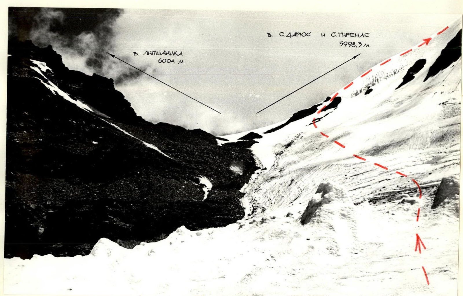
Fig.4. Start of the route. Photo from the glacier cirque towards 5598.3 m and 6004 m. Lens INDUSTAR 50–2.