
Ascent Passport
-
Class: High-altitude technical.
-
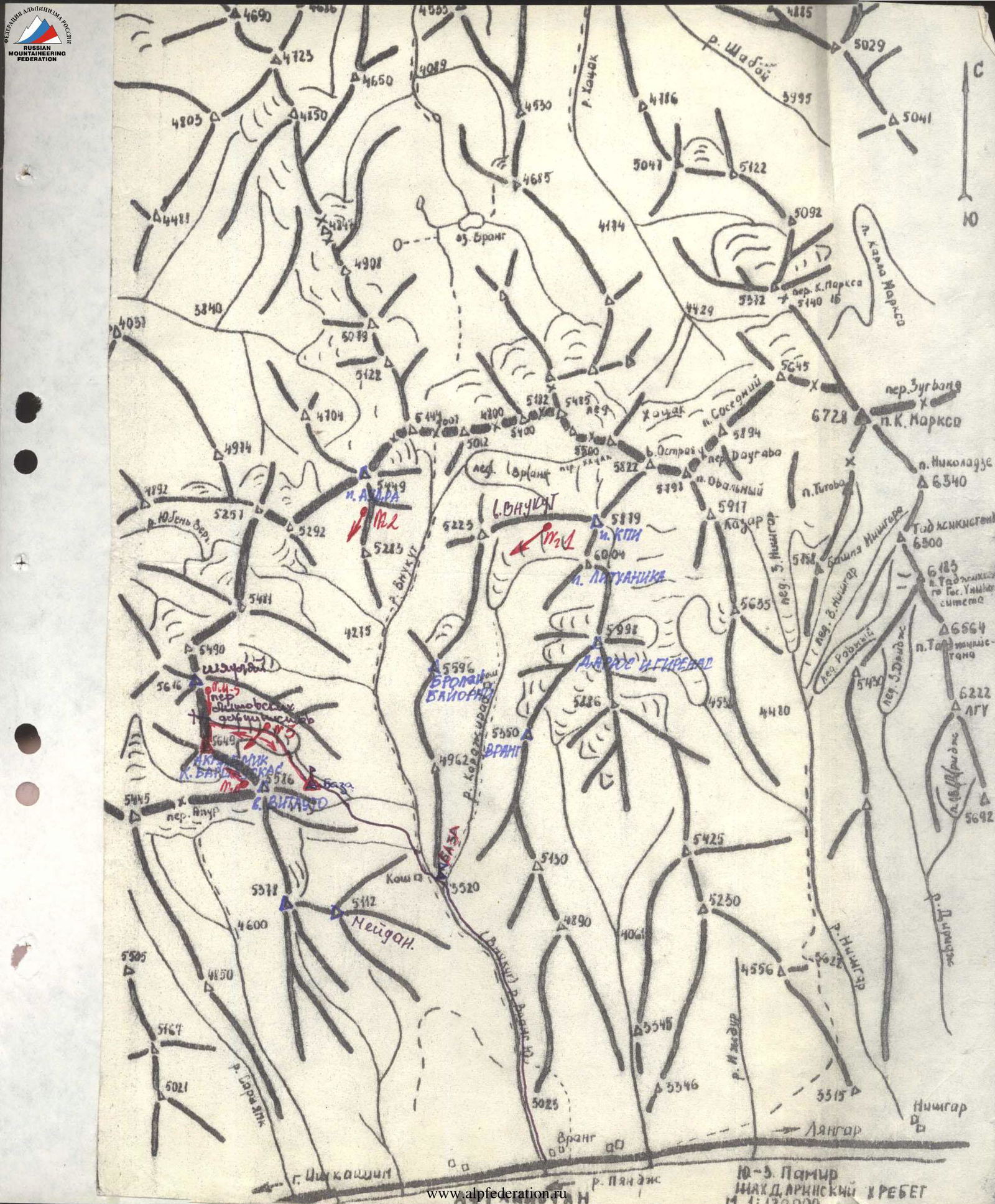
South-West Pamir, Shakhdarin Range, Vahan Range, Vnukut gorge.
-
Peak 5649 m (Academician Kazimieras Baršauskas) via the North ridge.
-
Proposed 4A category of difficulty, combined, first ascent.
-
Height difference: length: Length of sections with 4–5 category of difficulty — 80 m. Average steepness of main rock sections — 75°, average steepness of ice sections 40–45°.
-
Pitons hammered: Rock — 3, ice — 21, chocks — 5.
-
Travel hours from base camp — 1 hour.
-
Overnights: 1 — under the glacier on a grassy area.
-
Leader: PAULIKAS Vidmantas Juozovich 2nd sports category Participants: BUROKAITĖ Judita Vitautovna 2nd sports category, ASAVKIN Alexander Mikhailovich 2nd sports category, Mačiaris Vidmantas Petras 3rd sports category, GUDYALIS Algis Vitautovich Candidate Master of Sports
-
Coach: GUDYALIS Algis Vitautovich
-
Departure on the route: August 16, 1984. Return: August 16, 1984.
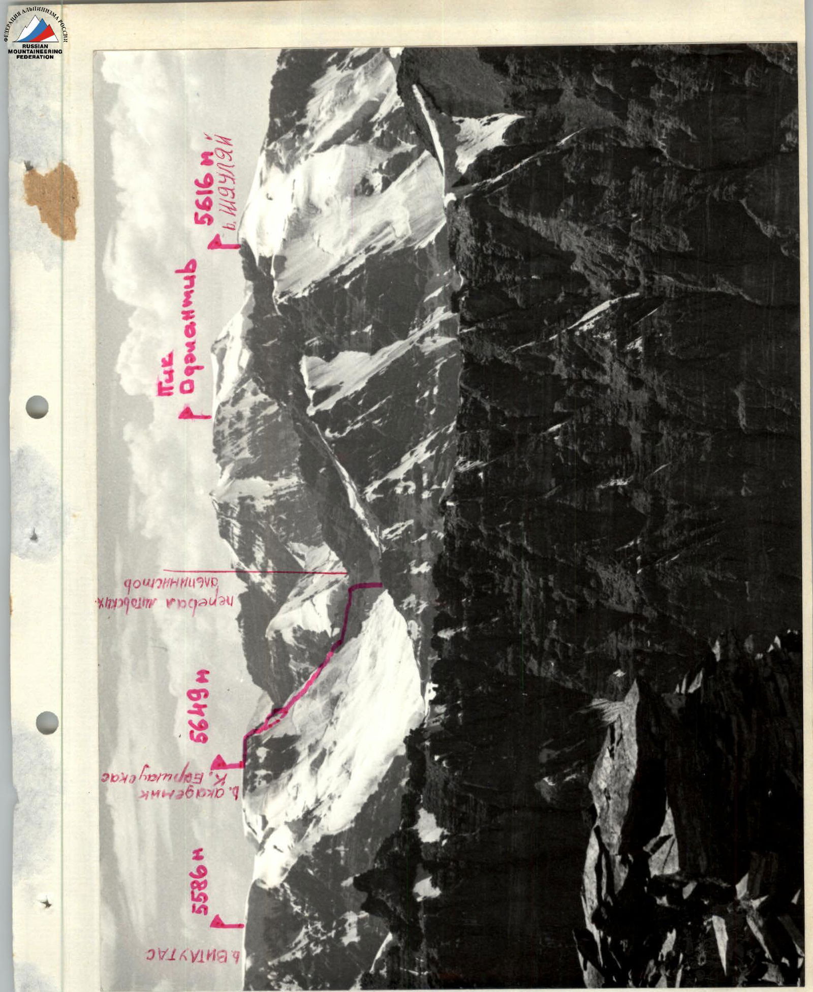
Panorama of the ascent area. View from the North-East. Photo #1. Lens "Industar-50-2" 3.5/50 06.84.08.
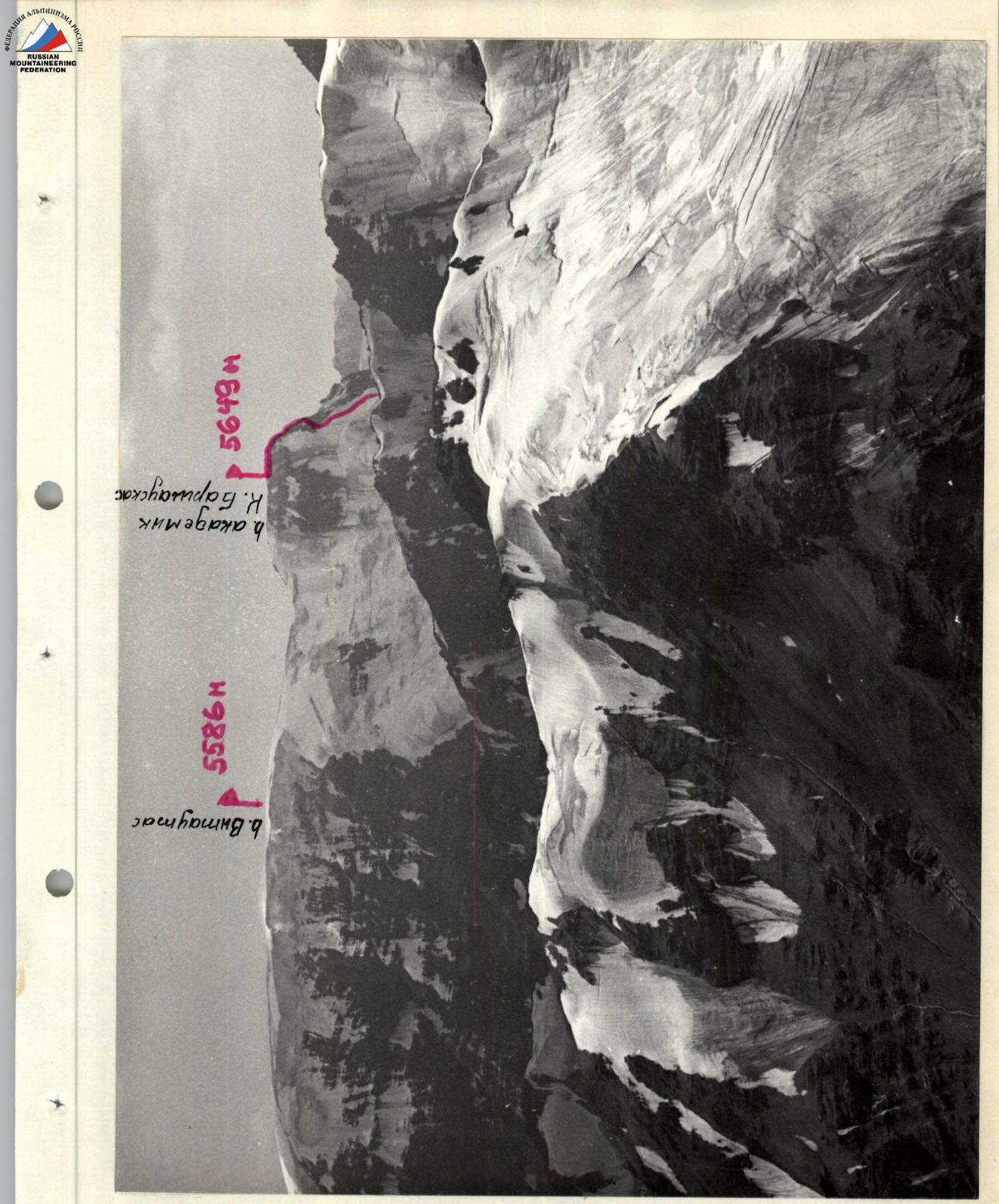
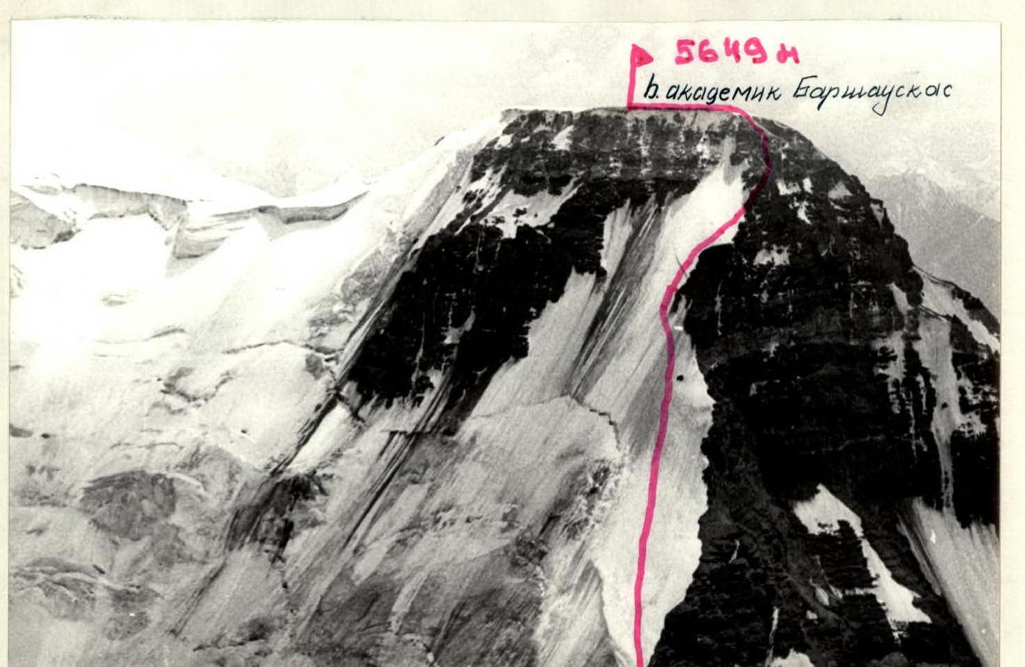
View of the peak from the North. Photo #2. Lens "Industar-50-2" 3.5/50 14.08.84.
General view of the peak from the glacier. Photo #3. Lens "Industar-56-2" 3.5/50 16.08.84.
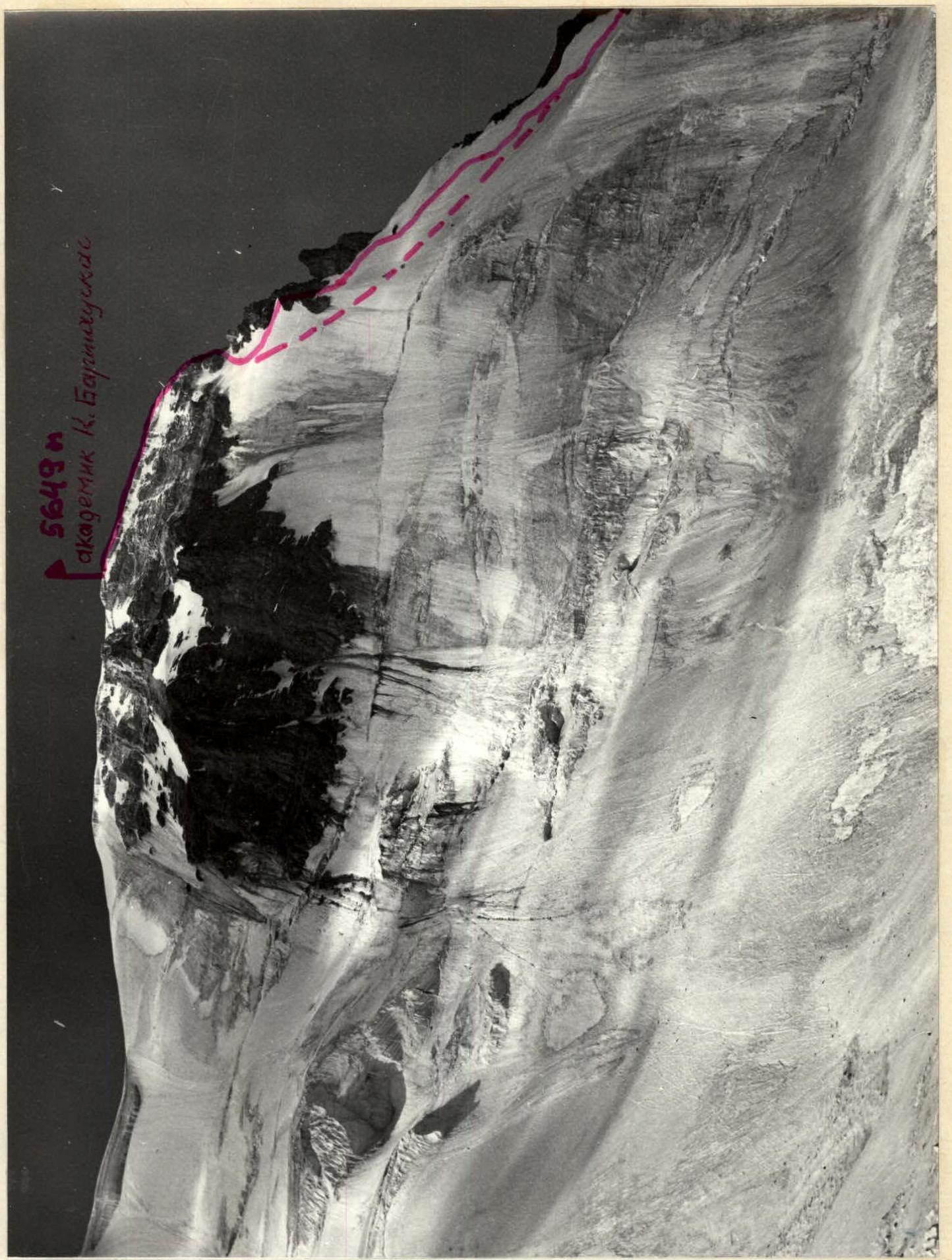
View of the peak from the ridge of Šiauliai peak. Photo #4. Lens "Industar 50-2" 3.5/50 16.08.84.
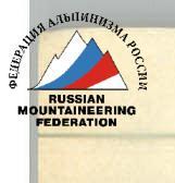
Descent from the peak of Academician Baršauskas. Photo #6. Lens "Industar-50-2" 3.5/50 16.08.84.
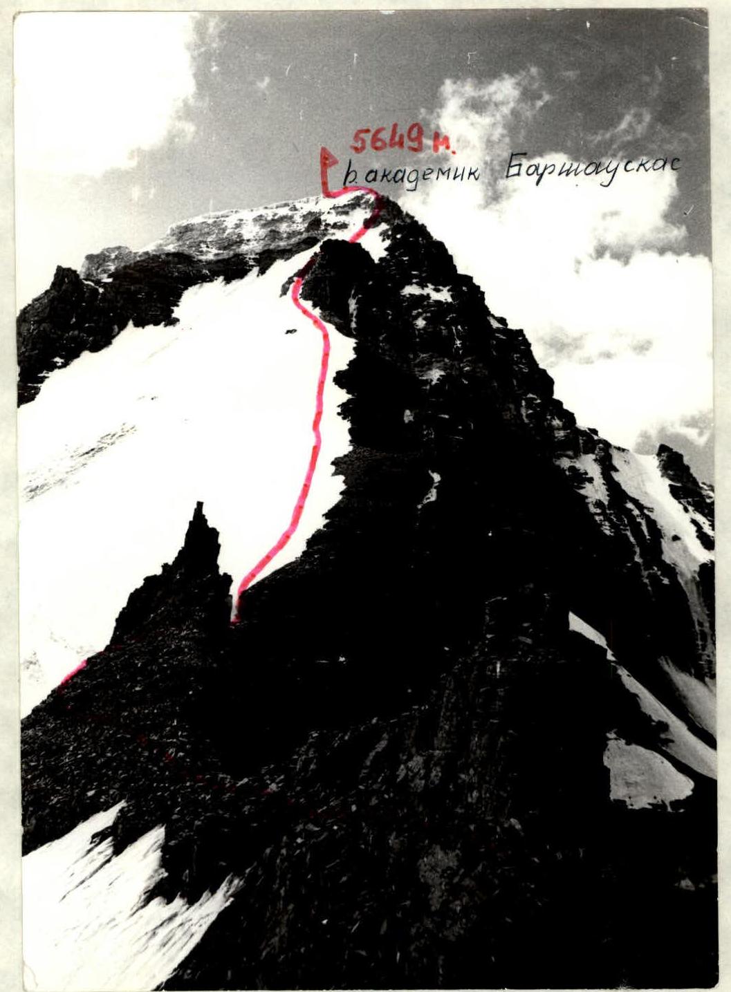
General view of the peak from the ridge of Šiauliai peak. Photo #7. Lens "Industar-50-2" 3.5/50 16.08.84. From the base camp, located at the confluence of the Vnukut and Chondzhirav rivers, the group departed on August 15, 1984, at 15:00. At this time, it is safe to cross the Vnukut river; after 15:00, the water level rises sharply.
They reached the intermediate camp — a grassy field under the northern buttress of peak 5586 m (Vytautas) — in 2.5 hours.
The ascent was planned for August 16, 1984. Departure from the intermediate camp at 7:15. It takes almost 1 hour to walk to the glacier located in the cirque of the peaks:
- 5586 m (Vytauto),
- 5649 m (Academician Kazimieras Baršauskas),
- 5616 m (Šiauliai).
The glacier can be traversed without crampons; there is a gentle exit on the left (in the direction of travel) part. The ascent to the Lithuanian Climbers' Pass (5250 m), located between peaks 5649 m and 5616 m, takes about 2 hours. From the pass — the beginning of the route.
The group worked in 2 teams:
- I — Asavkin — Paulikas,
- 2 — Mačiaris — Burokaite — Gudyalis.
Scree is traversed simultaneously. Belaying is necessary on the snow-ice slope with a steepness of 45°. Six ropes up to the gendarme. Belaying is with pitons. Crampons are used. The gendarme is bypassed on the left along the snow-ice slope (1 rope). Further, our group ascended up the very broken rocks. Rockfall hazard! It is recommended that the next ascenders go all the time along the snow-ice slope to the rocks of the pre-summit tower. Steepness — up to 40°. Belaying is with pitons (2 ropes). Along the rocks — exit to the summit, climbing is difficult. Belaying is with pitons (2 ropes). Exit to the summit plateau along the ice 5–8 m, steepness up to 30°. The group reached the summit at 17:00. They descended via the ascent route, as some gear was left on a convenient platform during the ascent. It is recommended that the next ascenders descend along the north-eastern slope between peaks 5649 m and 5586 m. Snow-ice slope, steepness up to 45°. To ensure safety, the group traversed the entire route using fixed ropes.
The passage of the entire route (from the pass to the summit) by well-prepared groups will take 4–6 hours, depending on the condition of the snow-ice slope.
10-5 Pamir Shakhdarin Range
Route description by sections
Along the scree and further along the glacier to the Lithuanian Climbers' Pass, where the route begins. Traverse in crampons.
Section 0–1 — about 150 m along the scree to the snow-ice slope. Traverse simultaneously.
Section 1–2 — snow-ice slope, 6 ropes, steepness 40–45°. On the right, there are broken rocks that end in a wall. It is not recommended to go along them. Rockfall hazard! Rocks can be dislodged by rope. 2–2 hours.
Section 2–3 — bypassing the rocky gendarme along the snow-ice slope. 1 rope, slope steepness 45°. 4
Section 3–4 — ascent along the rocks to the ridge. Rocks of medium difficulty. Steepness 75–80°. Belaying is with pitons. Rockfall hazard! Rocks can be dislodged by rope! 3
Section 4–5 — snow-ice slope, 2 ropes, steepness 35–40°. To the right, there are broken rocks with ice, which are not recommended. 6
Section 5–6 — ascent to the summit tower. Difficult climbing, 2 ropes, steepness 80–85°. 8
Section 6–7 — ice slope. 5–8 m, steepness 20–25°. Exit to the summit plateau.
The ascent to peak 5649 m (Academician K. Baršauskas) from the Lithuanian Climbers' Pass takes 7 hours. Descent via the ascent route. It is recommended that the next ascenders descend along the north-eastern snow slope.
The ascent takes 20–21 hours.