Report
ON THE FIRST ASCENT OF PEAK 5596 M (BROLYAI BAYORAS) VIA THE NORTHERN RIDGE of the Sports Committee of the Lithuanian SSR Team (South-West Pamir, Shakhdara Range, Vakhan Range)
1340, IV-V, 257, 70°, 17 cm, 14 m of ice, 9 h, 3 days.
Team Leader: BAYORENE Yu.G. Coach: GUDYALIS A.V. Committee for Physical Culture and Sports under the Council of Ministers of the Lithuanian SSR – 232075, Lithuanian SSR, Vilnius, Zhemaites 6, tel. 63-53-53.
Team Leader: Bayorene Jurate Genrikovna Lithuanian SSR, Kaunas, Grazhinos II-27, h.p. 73-46-77, w.p. 22-46-38.
Coach: Gudyalis Algis Vitautovich 233021, Lithuanian SSR, Kaunas, Kanyuku I-4–17, h.p. 26-45-91, w.p. 22-53-41.
All heights mentioned in the report are taken from a topographic map.
Route Profile

Brief Historical and Geographical Overview of the Area
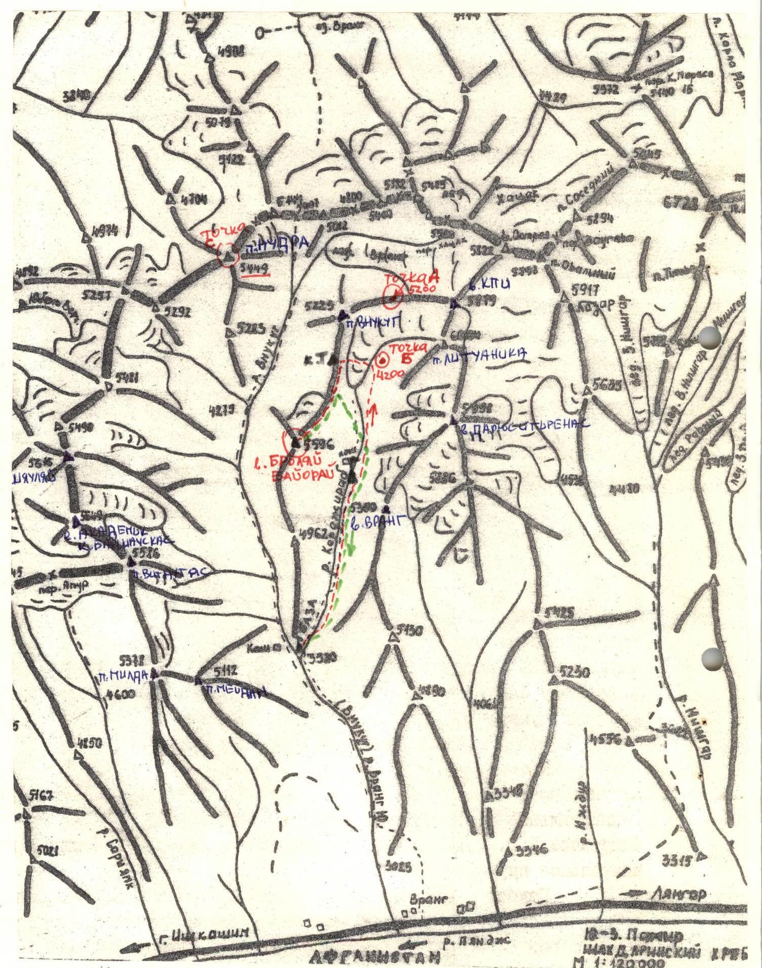
The peaks are located in the South-West Pamir, in the eastern part of the latitudinal section of the Shakhdara Range, specifically in the Vakhan Range:
– 5350 m (Vrang) – 5998 m (Darius and Girenas) – 6004 m (Lituanica) – 5879 m (KPI) – 5649 m (Academician Barshauskas)
The nearest areas explored by climbers are:
– the areas of Peak Marx (6726 m) and Engels (6510 m) to the east; – the areas of peaks 6138 m (Armed Forces) and 6038 m (Baikonur) to the west.
Travels through the Pamir in 1904 by B.A. Fedchenko explored and described the area of the Shakhdara Range, located between the Shakhdara and Pyanj rivers.
Climbing exploration of the Shakhdara Range began in 1946, when Peak Karl Marx was conquered. In subsequent years, a number of expeditions were organized, mainly in the area of peaks Marx and Engels.
The central part of the Shakhdara Range began to be explored in 1974, when the walls, later named Peak Luknitsky, were accidentally noticed by V.P. Nekrasov.
In 1975, an expedition of the Armed Forces led by Nekrasov V.P., establishing a base camp on Lake Zardiv, conquered Peak 5800 m via a route of category 5B difficulty on the NW edge. This peak was named Luknitsky.
In subsequent years, army climbers, as well as other climbing expeditions, completed a number of interesting routes of categories 5B and 6B difficulty in this area, becoming prize-winners of the USSR Climbing Championship.
However, the part of the Shakhdara Range between peaks Dzhentim and Marx remained unknown to climbers until 1983 and was visited only by rare groups of tourists. The reasons for such late exploration of the area are likely:
– the fact that the peaks of these mountains are not visible from populated areas and the road; – and also the more focused attention of climbers on the area of peaks Engels, Marx, Luknitsky, and Mayakovsky.
Preliminary reconnaissance of the Vakhan Range area (Yangung, Saryyang, Vnukut, Chondzhirav valleys) was carried out in 1983 by a reconnaissance group of the Sports Committee of the Lithuanian SSR (Gudyalis A.V. and Sinutis R.Yu.). They:
– conducted photo surveys of the peaks of the Vakhan Range; – visually studied the routes.
The most attractive peaks for climbers are those that have not been climbed yet, especially if these peaks reach or exceed 6000 m in height.
In the summer of 1984, an expedition of the Sports Committee of the Lithuanian SSR led by Gudyalis A.V. arrived in the Vnukut valley with the goal:
– to study this area from a climbing perspective; – to conquer previously unclimbed peaks; – to give them corresponding names.
The expedition established its base camp at the confluence of the Vnukut and Chondzhirav rivers, at an altitude of 3520 m, approximately 3 hours' walk from the village of Vrang.
From a climbing perspective, the area is very interesting for climbers from 2nd category to Candidate Master of Sports inclusive. There are many routes on the peaks ranging from category 3A to 5B difficulty, including:
– rock; – combined; – snow and ice routes.
Approaches to the routes take 3–8 hours from the base camp. Many first ascents are possible.
The rivers are turbulent. In the second half of the day, they are difficult to cross. The weather is generally stable, although in August 1984, a sudden cold snap, thunderstorms, and rain were observed for a week, resulting in many ascents not being completed.
The flora and fauna of the valley are not rich. Rarely encountered are:
– ephedra; – Rhodiola rosea.
In the upper reaches of the Vnukut and Chondzhirav rivers, there are pastures and summer pastures for shepherds.
Location of Peak 5596 m (Brolyai Bayorai)
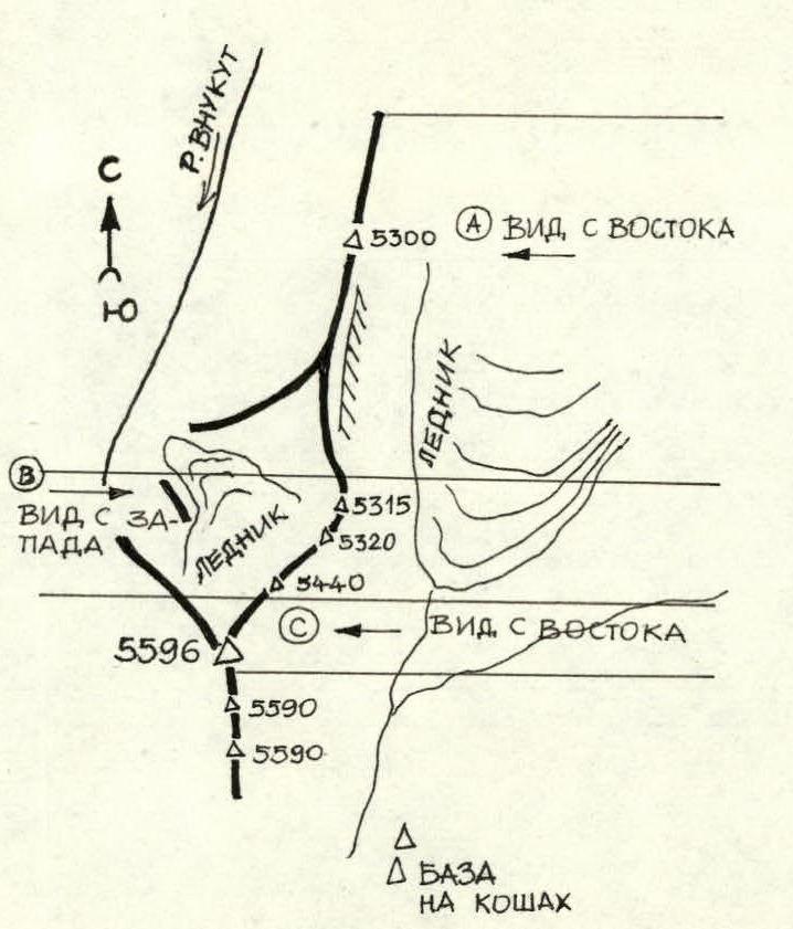
The peak is located in the southern spur of the Shakhdara (Vakhan) Range, forming a wedge between the Vnukut and Chondzhirav rivers. The height of the peak is 5596 m. The peak is visible from the Chondzhirav glacier and from the slopes of the ridge 5440 m, 5320 m. From the peaks Lituanica, Darius and Girenas (to the east), the peak appears as a jagged wall. When approaching, the peak is not visible. The NW slope of the peak is a wall over a kilometer high, which is obscured by small lateral spurs extending to the west. There is snow and ice on the wall.
Routes of category 5B difficulty are possible on the NW wall. The rock structure of the peak is layered, and the rocks are highly fractured. Possible descent routes:
– via the ascent route (in bad weather); – via the ascent route to the Main Saddle and then down the couloir to the southeast.
The tactical plan was to complete the route in 2 days, but due to bad weather, the route was completed in 3 days.
The team was divided into pairs:
– Simutis R. — Varsackis B.; – Navickas S. — Bayorene Yu.; – Gudyalis A. — Paulikas V.
During the ascent, the pairs changed. On the route, the lead was rotated. Section R5–R6 was first climbed by Varsackis B., R13–R14, R15–R16 by Simutis R. R20–R21 was climbed by Gudyalis A.
Preliminary processing of sections was not planned (not carried out). On sections R5–R6, R13–R14, R15–R16, R20–R21, fixed ropes were used.
During the ascent, the team worked 10 hours a day, including 2 hours of rest. Overnight stays were organized in safe places on platforms on the rocky ridge:
– one at an altitude of 5250 m; – another at 5526 m.
On the route, there were no falls or injuries. The team did not use new equipment or non-standard technical techniques.
In bad weather, the team continued the ascent. Communication with observers was maintained via radio.
August 11, 1984.
Departure from the base camp at the confluence of the Vnukut and Chondzhirav rivers — 9:00. Approach to the glacier tongue — 16:30. Exit to the ridge — 17:30. Signal cairn — 18:00. Overnight stay — 19:00.
August 12, 1984.
Start on the route — 9:00. On the saddle — 12:00. Approach to the key section — 14:00. Summit — 17:00. Start of descent — 18:30. Overnight stay — 19:00.
August 13, 1984.
Start of descent — 9:30. At the base camp — 17:00.
Description of the Route to Peak 5596 m (Brolyai Bayorai) Category 4B Difficulty via the Northern Ridge
From the base camp at the confluence of the Vnukut and Chondzhirav rivers, the path to the bivouac under the peak goes along the right bank of the Chondzhirav river.
The approach from the base camp to the glacier tongue takes 4–4.5 hours.
Further:
– across the glacier to the left, in the direction of the "fence" ridge; – up the talus to climb onto the "fence"; – at the exit to the ridge — a "signal" cairn.
The approach to the signal cairn corresponds to category 1B.
From the signal cairn — to the rocky ascent (5300 m).
After descending 80–100 m — a convenient platform for an overnight stay.
Further, after climbing 150 m on fractured rocks, approach a snow and ice slope with a steepness of 35° — 130 m (hook protection!). Then a rocky wall 6 m (IV+ 75°). After climbing 40 m along the ridge, descend down via rappel (8 m, 80°) and approach a snow and ice slope with a steepness of 35°, length 80 m. Descend down the slope (hook protection!) to the Main Saddle. At the bottom, there is an ice overhang — be cautious! From the signal cairn to the Main Saddle — 4 hours. From the saddle, after climbing 40 m, approach a 40-meter wall (IV, 60°), which is climbed on the right side. Further up the fractured ridge. After climbing 100 m, approach a second 40-meter wall (III, 30°), which is climbed directly — rockfall hazard! After climbing 100 m along the ridge, approach the key section — the Black Wall — 40 m long (V, 80°) with two cracks. The wall is climbed via the right crack (hook protection!). It is recommended that the first climber goes without a backpack. After climbing 40 m along the ridge — descend via rappel (10 m, 85°). Then, bypass the gendarme on the right and along the right side of the pre-summit ridge, exit to the summit 5596 m. From the signal cairn to the summit — 9 hours of climbing.
On the snow and ice slopes, ice screws were used for protection, on rocky sections — rock pitons and stoppers. In total, used:
– 9 ice screws; – 27 rock pitons and stoppers.
Descent — via the ascent route (category 4B difficulty) and further down the couloir to the southeast.
Descent from the summit:
– to the base — 6 hours; – to the col — 4 hours.
View from the East
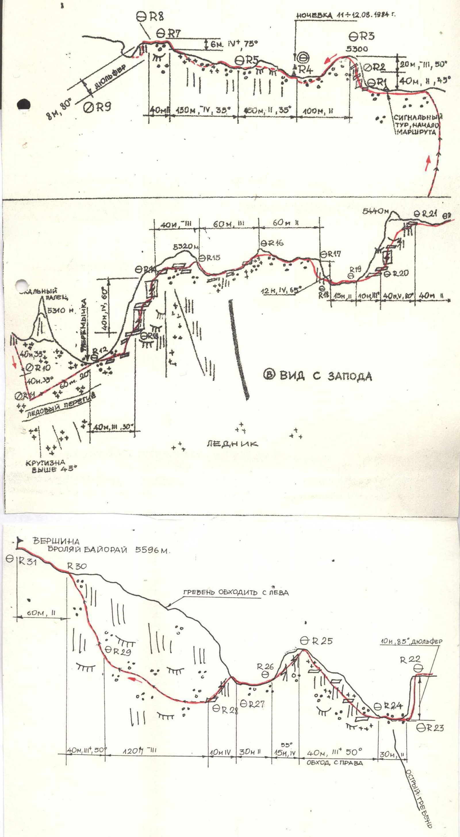
| Section | Difficulty Category | Steepness (°) | Length (m) | Ice Screws | Rock Pitons/Stoppers | Remarks |
|---|---|---|---|---|---|---|
| R1–R2 | 2 | 45–50 | 40 | 2 | - | - |
| R2–R3 | 3 | 50 | 20 | - | - | - |
| R3–R4 | 2 | 35 | 100 | - | - | - |
| R4–R5 | 2 | 35 | 150 | - | - | - |
| R5–R6 | 4 | 35 | 130 | 1 | 5 | Used fixed ropes |
| R6–R7 | 4+ | 75 | 6 | - | 1 | - |
| R7–R8 | 2 | 30 | 40 | - | - | - |
| R8–R9 | 80 | 8 | - | 1 | Rappel | |
| R9–R10 | 35 | 40 | 2 | - | Sport descent | |
| R10–R11 | 35 | 40 | 1 | - | “” | |
| R11–R12 | 20 | 60 | - | - | - | |
| R12–R13 | 3 | 30 | 40 | - | - | - |
| R13–R14 | 4 | 60 | 40 | 4 | - | Used fixed ropes, rockfall hazard |
| R14–R15 | 3 | 30 | 40 | - | - | - |
| R15–R16 | 3 | 30 | 60 | 3 | - | Used fixed ropes, rockfall hazard |
| R16–R17 | 2 | 25 | 60 | - | - | - |
| R17–R18 | 4 | 65 | 12 | 1 | - | Sport descent |
| R18–R19 | 2 | 20 | 15 | - | - | - |
| R19–R20 | 3+ | 30 | 10 | - | - | - |
| R20–R21 | 5 | 80 | 40 | 4 | 1 | Used fixed ropes, climbed without |
| a backpack | ||||||
| R21–R22 | 2 | 20 | 40 | - | - | - |
| R22–R23 | 85 | 10 | - | 1 | Rappel | |
| R23–R24 | 2 | 20 | 30 | - | - | - |
| R24–R25 | 3+ | 50 | 40 | - | - | Fractured rocks, bypass on the right |
| R25–R26 | 4 | 55 | 15 | - | - | - |
| R26–R27 | 2 | 20 | 30 | - | - | - |
| R27–R28 | 4 | 50 | 10 | - | - | - |
| R28–R29 | 3 | 40 | 120 | - | - | Bypass on the left |
| R29–R30 | 3+ | 50 | 40 | - | - | - |
| R30–R31 | 2 | 30 | 60 | - | - | At the summit, a cairn 1.5 m high |
Eugenijus Bayoras (1953–1982)
Eugenijus Alfonsovich BAYORAS was born on February 20, 1953, in Kaunas. In 1972, he graduated from high school and entered a technical school, graduating in 1972, and obtained the specialty of a cinema mechanic.
From 1972, he worked at the Kaunas Rubber Products Factory "Inkaras" in the energy department as an electrician.
From 1965, E. Bayoras was a member of the ski section, a multiple prize-winner of republican championships.
From 1973, E. Bayoras began to engage in mountaineering. In 1975, he was elected chairman of the Kaunas Mountaineering Federation. He founded the mountaineering section at the "Inkaras" factory, which he successfully led until his last days. He was noted for his qualities as an excellent organizer.
In 1977, he participated in a geodetic and cartographic expedition to the Pamir, where he:
– climbed unnamed peaks; – named them after Kaunas and Maironis.
Showing high sports results, he became a member of the Lithuanian mountaineering team and the Lithuanian rock climbing team.
During the period from 1973 to 1982, E. Bayoras participated in II expeditions of the Lithuanian mountaineering team.
He successfully led the first winter expedition of Lithuanian climbers in 1982, during which an ascent was made to Elbrus.
In 1981, Eugenijus became the champion of the Baltic States, having climbed Ushba.
In 1981 and 1982, he was a member of a team participating in the USSR mountaineering championship.
He repeatedly placed in the top ten best climbers and rock climbers of Lithuania.
E. Bayoras was a mountaineering instructor, a Candidate for Master of Sports.
On July 18, 1982, he died while climbing Peak Korzhenevskaya.
Romualdas Bayoras (1954–1980)

Romualdas Alfonsovich BAYORAS was born on December 8, 1954, in Kaunas. In 1972, he graduated from high school and began working at the Kaunas Radio Factory. At the same time, he studied at the evening department of the Construction Faculty of the Kaunas Polytechnic Institute. Together with his brother Eugenijus, he engaged in skiing, was a multiple prize-winner of Lithuanian championships.
In 1973, he began to engage in mountaineering. In 1976, he participated in a winter expedition to Tian Shan.
From May to October 1977, Romualdas worked in a cartographic expedition to the Pamir. Together with friends, he climbed unnamed peaks, three of which were named after Lithuanian names:
– Kaunas; – Maironis; – Rasa.
During complex ascents, Romualdas was often the lead.
In 1978, he became a member of the Lithuanian team. In the summer, he climbed Peak Zamok in the Fann Mountains via a route of category 5A difficulty and became a bronze medalist of the Lithuanian mountaineering championship.
As part of the republican team, he attempted to climb a seven-thousander (Peak Lenin, 7134 m). However, due to unexpected participation in rescue work together with Latvian climbers, the plans were not realized.
In 1979, R. Bayoras began working at the Kaunas House-Building Combine. He was studying in his 5th year.
In the winter, Kaunas climbers organized a traditional expedition to Kyrgyzstan, during which Romualdas climbed Kalkush via a route of category 5A difficulty. For the first time in the history of Baltic mountaineering, a route of category 5A difficulty was climbed in winter conditions.
In the summer of the same year, he worked at the "Artuch" alpine camp, completed 1st category and approached the Candidate for Master of Sports.
Upon returning home, he actively participated in the activities of the Kaunas Mountaineering Club.
On February 17, 1980, he died from illness.