
Description of the Route to Peak 5148 m, Category 3B (First Ascent) via the Southeast Ridge
From the base camp, follow the trail along the Vyz-dara River to the "lower campsite" on the terminal moraine ridges of the Vyz Glacier. The journey from the base camp to the campsite takes 2.5–3 hours on foot.
From the "lower campsite":
- follow the surface moraine of the Vyz Glacier
- in the direction of the gendarme at the end of the ridge, visible from the campsite
- keeping to the right side
- leaving the moraine lake on the left
Approach the northern slopes of the ascent object (Fig.1).
It takes 2.5–3 hours to reach the gendarme from the "lower campsite". Then, ascend a steep snowy slope (30–35°) about 50 m long to reach the snowy plateau of the ridge. Continue leftwards and upwards (along the route) through steep scree and heavily broken rocks, bypassing the "Black Finger" and the sharp rocky ridge to the shoulder of the buttress (see Fig.2). Movement is simultaneous in rope teams.
From the shoulder of the buttress, ascend rightwards and upwards through steep ledges (total length about 100 m) to a snowy couloir (piton protection!) (see Fig.3). Then, continue rightwards and upwards through the snowy couloir to a wall and further up the ridge to the gendarme's summit (see Fig.4). The upper part of the couloir has ice under the snow. Piton protection is used in the couloir.
Rope team movement:
- Alternating movement on the ledges to the couloir
- Simultaneous movement on the pre-summit ridge
There is a cairn on the gendarme's summit. It takes 5–6 hours from the base of the gendarme to its summit. There is a bivouac site on the ridge behind the gendarme's summit.
From the bivouac site, follow a relatively easy, heavily broken rocky ridge, bypassing the pre-summit "red" gendarme on the left (along the route), to reach the summit (see Fig.5). There are good bivouac areas behind the "red" gendarme, on the summit. Movement is simultaneous in rope teams. Protection is through rock features.
It takes 2.5–3 hours from the gendarme's summit to the main summit.
The descent follows small scree down the southern slope of the ridge, then continues down the moraine to the "lower campsite", taking a total of 2.5–3 hours.
Equipment: Personal — standard; Group:
- main rope 2×40 m
- rock hammer 2 pcs.
- rock pitons 8–10 pcs.
- carabiners 12 pcs.
Brief Geographical Description of the Ascent Area
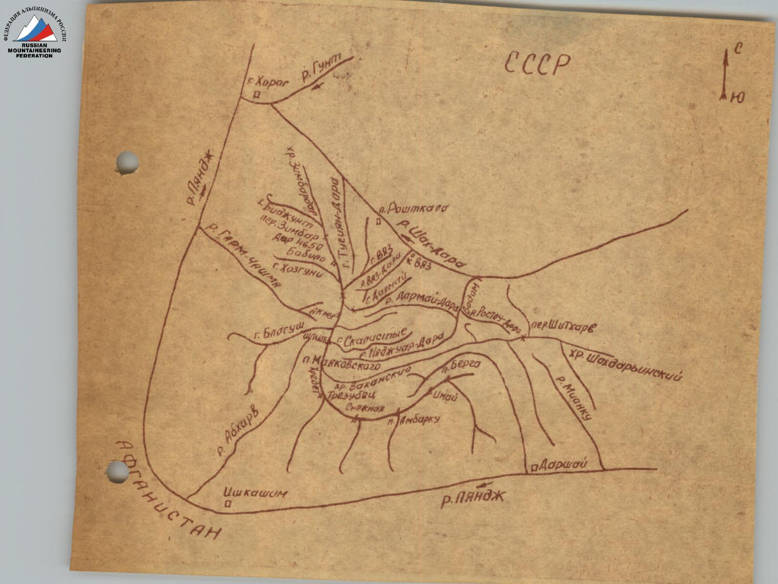
The area of the Kharkov Sports Committee's 1975 expedition is the Vyz-dara River basin, a tributary of the Shakhdara River in the western part of the Southwest Pamir.
The Southwest Pamir region includes mountain ranges between the Pyanj River and the Shakhdara River, forming:
- the Zimbardor-Vakhan Range, stretching from the Zimbardor Pass to the Shitkhargv Pass;
- the Shakhdarya Range, extending eastwards from the Shitkhargv Pass.
Rivers flowing from the slopes of the Zimbardor-Vakhan Range include:
- Tusyandara,
- Vyz-dara,
- Badon-dara,
- Abkharv,
- Garm-Chashma.
The path to the Vyz-dara River goes through the city of Khorog — the center of the Gorno-Badakhshan Autonomous Region and Tajik SSR, then to Roshtkala, and to the village of Vyz, located at the confluence of the Vyz-dara River and the Shakhdara River. From there, follow the trail along the Vyz-dara River to a mineral spring on the left orographic bank.
The base camp is set up at this location, providing convenient access for ascents to the peaks of the Vyz and Darmay ranges. Elevations:
- Khorog — 2000 m above sea level,
- Vyz village — 2460 m,
- base camp — 3100 m.
The Vyz-dara River area is characterized by a pronounced mountainous relief with significant elevation changes, and the snow line is generally above 4000 m. Glaciation in the area is limited, mainly represented by the Vyz Glacier and hanging glaciers above 4500 m. The Vyz Glacier is located between 4000–4800 m and is covered by a thick layer of surface moraine in its lower part.
Characteristic peak elevations range from 4500–5300 m. The climate is predominantly dry and hot, with prevailing sunny days during June, July, and August. These features make the Vyz-dara River area promising for:
- organizing expeditions
- undertaking mountaineering ascents of various categories
The slopes of the Darmay Range facing the Vyz-dara River offer complex wall routes. The peaks of the Vyz Range provide a wide range of routes with varying difficulty, starting from easy ones. Besides mountaineering ascents, the peaks of the Vyz Range can be used for preliminary reconnaissance of wall routes on the Darmay Range peaks. Peak 5148 m is a suitable sporting objective.
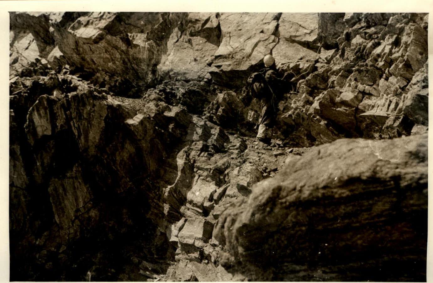
Fig.3. "The Wall", section R2–R3
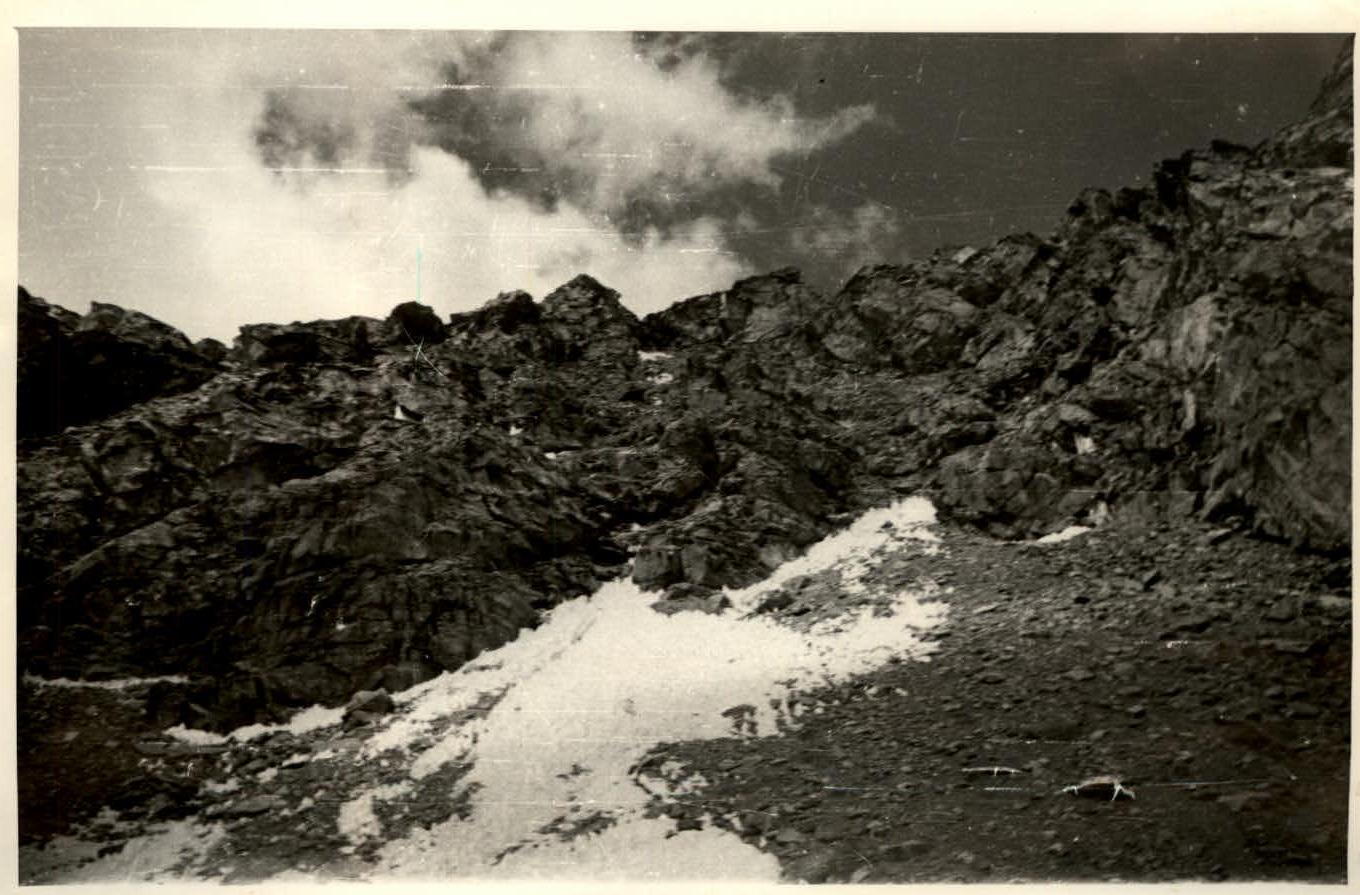
Fig.4. Ridge leading to the gendarme's summit, section R3–R4
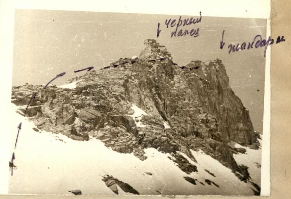
Fig.1. Beginning of the route, section R1–R2
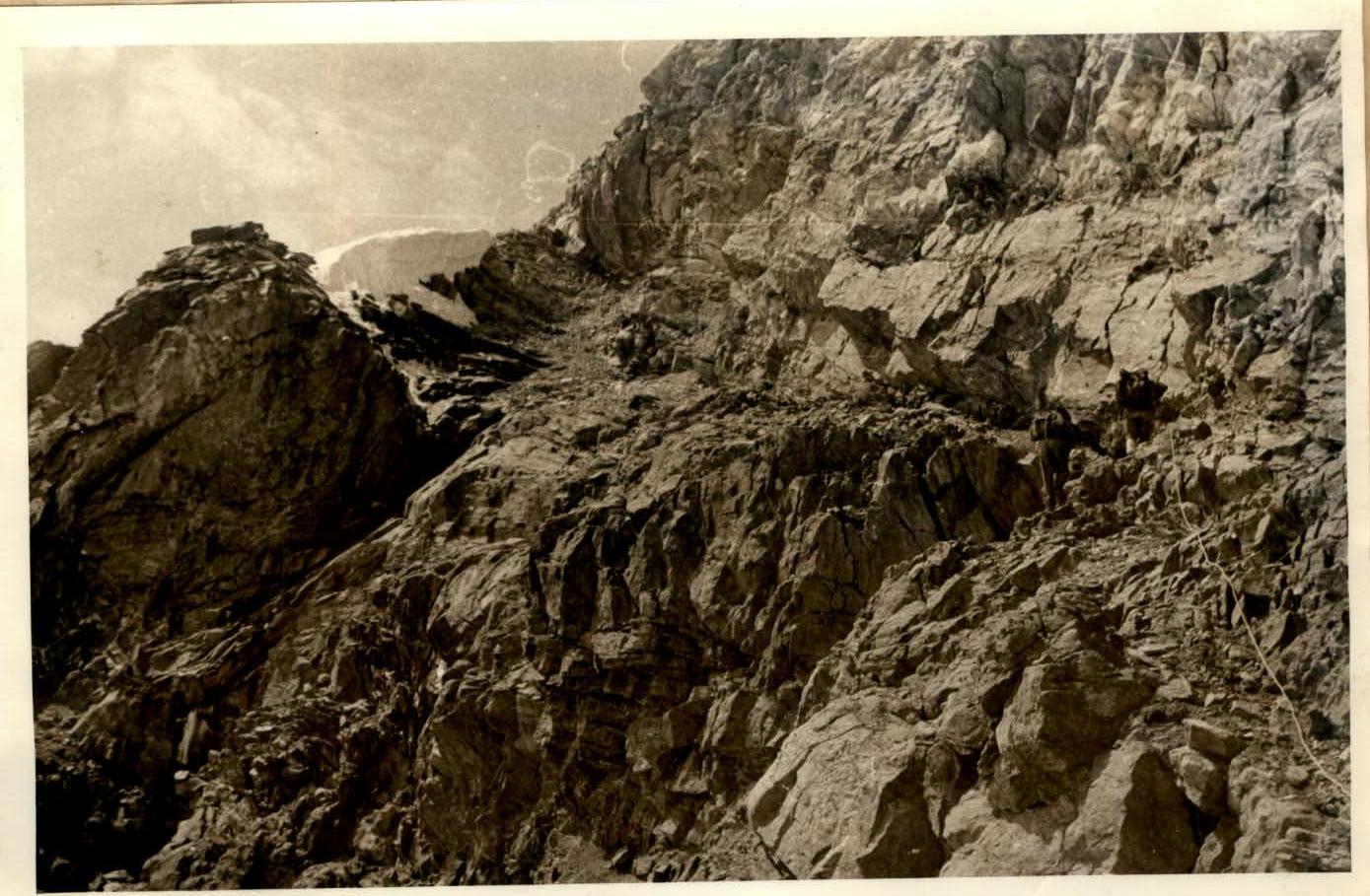
Fig.2. "The Shoulder of the Buttress", section R2–R3
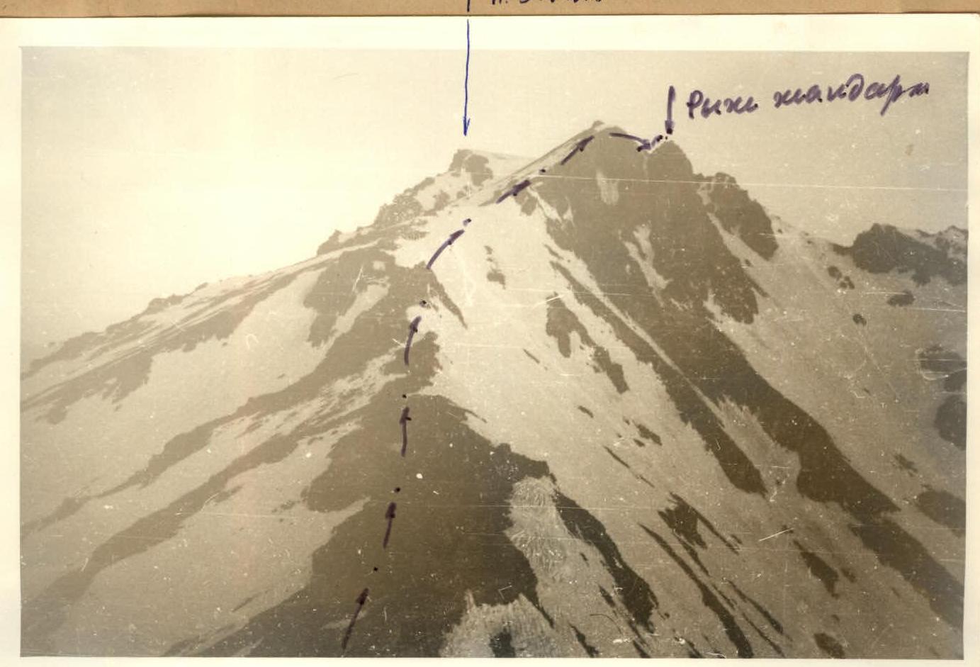
Fig.5. Pre-summit ridge (view from the bivouac site), section R4–R5
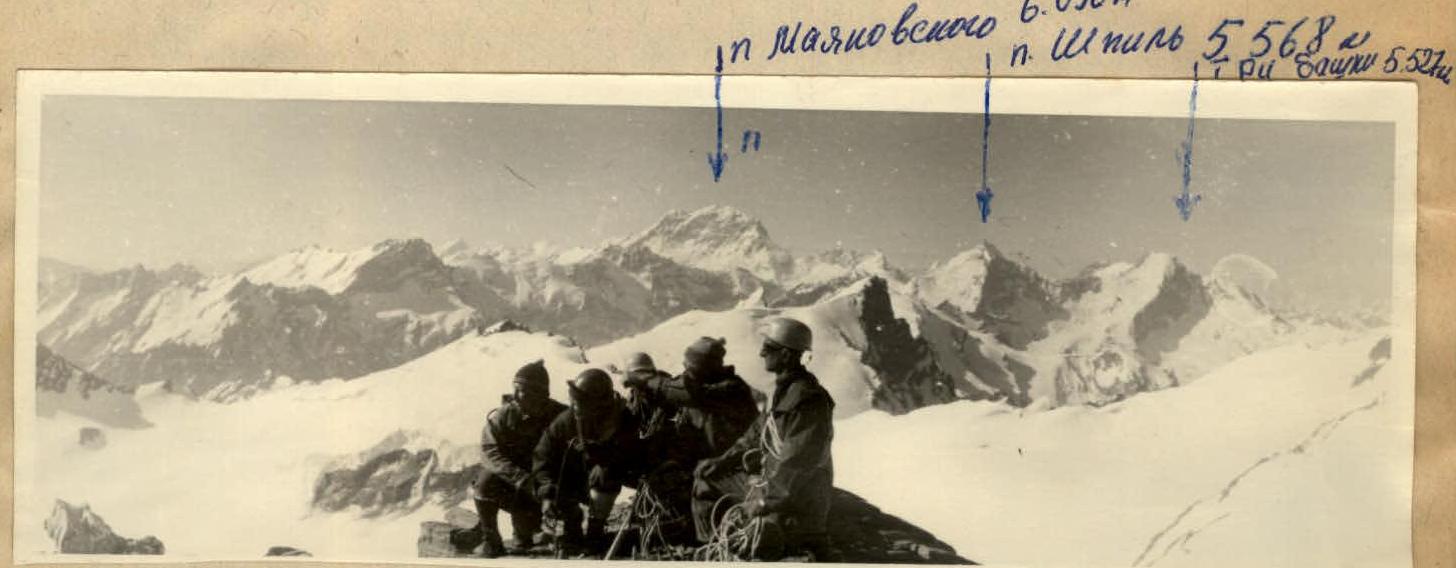
Peak 5148. Panorama of neighboring peaks.
TABLE OF MAIN CHARACTERISTICS OF THE ASCENT ROUTE TO PEAK 5148 m VIA THE SOUTHEAST RIDGE, CATEGORY 3B.
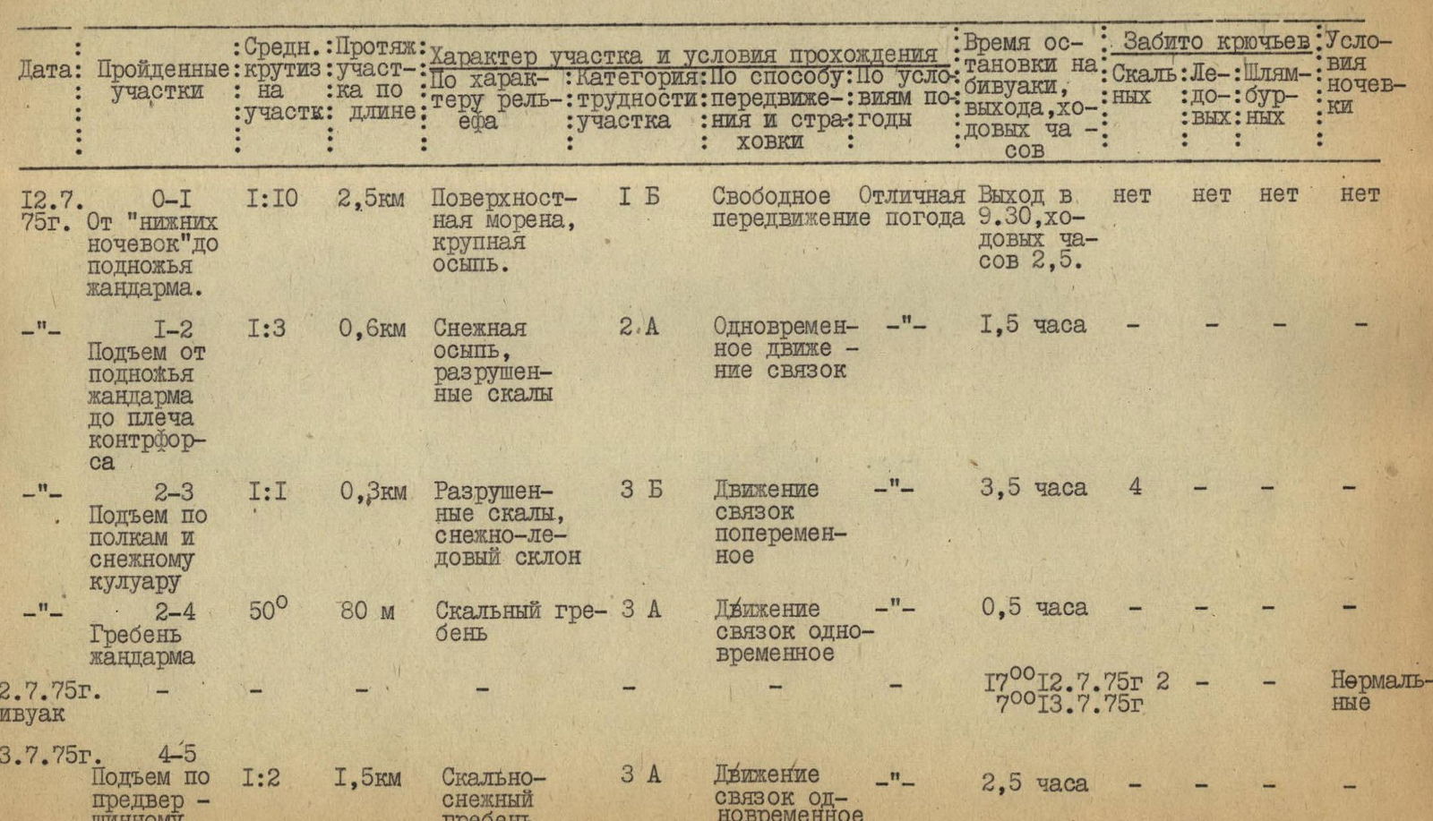
| Date | Sections Covered | Average Slope | Length | Section Characteristics and Conditions | Time on Bivouac, Departure, Climbing Hours | Pitons Used | Bivouac Conditions |
|---|---|---|---|---|---|---|---|
| Terrain Characteristics | Category of Difficulty | Movement Method | Weather Conditions | ||||
| 07/12/1975 | R0–R1. From "lower campsite" to the base of the gendarme. | 1:10 | 2.5 km | Surface moraine, large scree. | 1B | Free movement | Excellent weather |
| R1–R2. Ascent from the base of the gendarme to the shoulder of the buttress. | 1:3 | 0.6 km | Snowy scree, broken rocks. | 2A | Simultaneous movement in teams | – | 1.5 hours |
| R2–R3. Ascent via ledges and snowy couloir. | 1:1 | 0.3 km | Broken rocks, snowy-icy slope. | 3B | Alternating movement in teams | – | 3.5 hours |
| R2–R4. Gendarme's ridge. | 50° | 80 m | Rocky ridge. | 3A | Simultaneous movement in teams | – | 0.5 hours |
| 07/12/1975 | Bivouac | – | – | – | – | – | – |
| 07/13/1975 | R4–R5. Ascent along the pre-summit ridge. | 1:2 | 1.5 km | Rocky-snowy ridge. | 3A | Simultaneous movement in teams | – |
Protocol of the Ascent to Peak 5148, Category 3B (First Ascent)
Attendees:
- Ascent participants
- Kutetsky V.V. — leader
- Matveev Yu.I.
- Ptukhina Z.E. — group members
- Orlov E.Z.
- Sidorenko N.N.
- Pol V.G.
Reviewer — Spesivtsev A.E.
Speakers:
Kutetsky V.V.
On July 12th, at 9:30, from the lower campsite, we followed the moraine of the Vyz Glacier, keeping to the right side, and approached the ascent object from the north. Then, we ascended a steep snowy slope (30–35°) about 50–80 m long to reach a snowy shoulder of the ridge. Continuing leftwards and upwards through steep scree and heavily broken rocks, we bypassed the sharp rocky ridge ("knife") to reach the shoulder of the buttress. Protection was simultaneous.
Then, we ascended via ledges to a snowy couloir. For safety, two rock pitons were hammered on the ledges and in the couloir. Movement was alternating.
The length of the ledges: 80–100 m. The length of the couloir: 80–100 m.
In the upper part of the couloir, there was ice under the snow. From the couloir, we moved rightwards onto the gendarme's ridge and then to its summit. Protection was simultaneous. A cairn was established on the gendarme's summit.
We reached the gendarme's summit at 16:30.
A bivouac was set up on the ridge behind the gendarme's summit. At 7:00 on July 13th, we continued along a relatively easy, heavily broken rocky-snowy ridge, bypassing the pre-summit "red" gendarme on the left (along the route), to reach the summit. We reached the summit at 10:30.
The descent followed small scree down the southern slope of the ridge, then continued down the moraine (following the ascent route) to the lower campsite, taking a total of 3–3.5 hours.
There were no concerns regarding the physical preparation of the group members. Some lack of tact in the behavior of Comrade Sidorenko and the exuberance of Pol were noted.
Question: How were the rope teams organized? Answer: The ascent participants were divided into the following rope teams:
- Matveev — Ptukhina
- Kutetsky — Orlov
- Sidorenko — Pol
The rope teams worked on the route such that each took turns leading. The lead climbers in the teams also switched places.
Question: How was safety ensured on the route and at the bivouac? Answer: On the route:
- Ropes were fixed on key sections
- Interaction between rope teams was organized
At the bivouac, two pitons were hammered for safety.
Sidorenko
Before the ascent object, additional reconnaissance of the ascent route was conducted to choose the final variant.
Question: How do you assess the category of the route? Answer: I assess the route as Category 3B. A significant obstacle during the ascent and descent was the altitude.
Spesivtsev A.E.
I consider the ascent and leadership of the sports group to be satisfactory.