DESCRIPTION OF THE FIRST ASCENT OF PEAK ENGELSA (6510 m) VIA THE SOUTH FACE — 6B CATEGORY OF COMPLEXITY
The team of climbers from the CS DSO "Trud" led by V. ROMANOV in 1988. The organizational plan included:
- Gathering all expedition participants in Osh on July 6;
- Traveling by car to the village of Isor;
- Setting up a base camp at an altitude of 4000 m;
- Acclimatization period;
- Ascending via the declared route;
- Wrapping up and evacuating the expedition.
The acclimatization period included:
- Organizing a storm camp at an altitude of 4850 m.
- Observing and scouting the route.
- A training ascent to Peak Pamyati zhertvam Tetnuldа (5850 m).
The team fulfilled all these plans. On July 13, the base camp was fully organized. On July 15, a storm camp was set up at an altitude of 4850 m, and the main part of the equipment and food supplies were transported to this camp.
On July 17-19, Korshunov V., Pavlichenko L., along with other expedition members, made an ascent to Peak Pamyati zhertvam Tetnuldа, category 5B complexity.
On July 17-20, Romanov B., Onishchenko V., Romanov V., and Gerken V. transported the main part of the equipment and food directly to the base of the south face of Peak Engels and processed its lower part.
By July 24, the ascent route was finalized, and the composition of the assault team was confirmed.
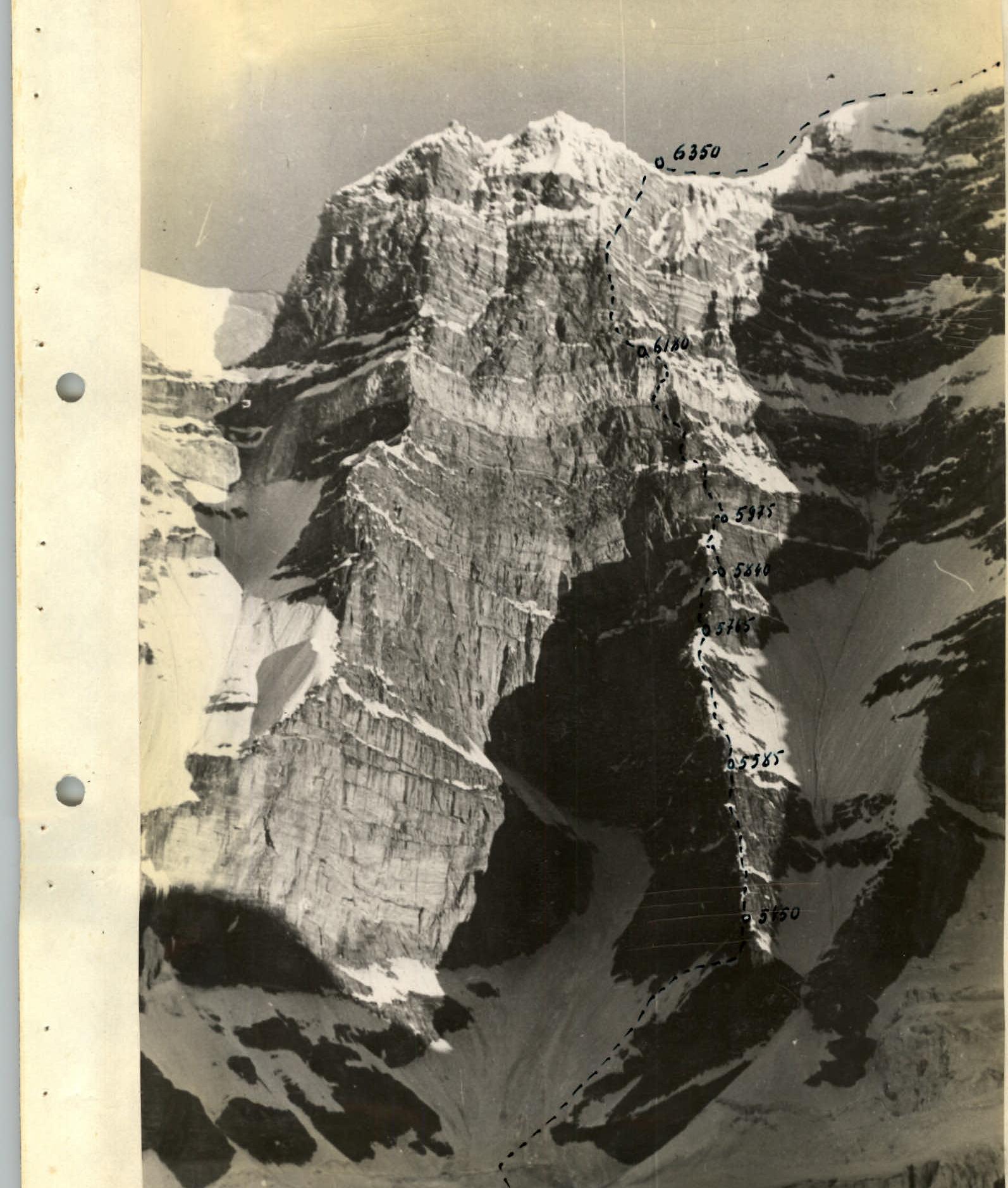
The tactical plan for the ascent was largely clear even before departing for the mountains. After being adjusted based on observations during preliminary exits, it looked as follows: the entire ascent route was conditionally divided into two parts. The first part, just over half of the route, consists of a steep counterfort with individual sheer sections and overhanging areas. The second part is an almost sheer, and in some places overhanging, wall. If on the first section it was possible to assume the feasibility of organizing decent overnight stays, on the second, such a probability was practically excluded. Given this situation, it was planned to pass the upper part with a minimal number of nights. The early illumination of the wall allowed starting the movement at 5:00–6:00 am.
The ascent plan involved departing from the storm camp (4850 m) to the counterfort on the first day. The second, third, fourth, and fifth days were planned for traversing the first part of the route (counterfort).
The sixth, seventh, and eighth days were allocated for passing the upper part of the route (wall). The ninth day was for descending to the saddle between Peak Marxa and Engels. The descent route was known to two members of the group (Romanov and Gerken).
The execution of the tactical plan did not require significant changes. The correctness of the time allocation for different sections of the route and the estimated difficulty were confirmed.

Route Processing
On July 18, the group consisting of Romanov B., Romanov V., Onishchenko V., and Gerken V. departed from the storm camp (4850 m) to process the route. They left at 8:00. On this day, they approached the base of the wall, crossed the bergschrund, and proceeded about 80 m along the firn slope (40°). Then the slope's steepness increases to 50–55°, and beneath a thin layer of snow, ice appears. The total distance from the bergschrund to the rocks is about 200 m. They moved with insurance, left a cache under the rocks, hung ropes, and descended back to the camp (4850 m). The descent from under the wall via the hung ropes to the camp took 40 minutes.
On July 19, they collected the remaining cargo for the cache: ropes, "hardware," and set out again for processing. They ascended via the hung ropes to the previous day's cache. The double team moved forward. The path led to the base of the counterfort—a traverse to the right under the rocks, along a snow-ice slope with a steepness of 55°. They hung about 100 m of safety lines. Exiting onto the ridge via a traverse to the right was impossible due to large cornices. The path upwards was determined to be along the rocky wall. Under the wall, they left cargo. They descended via the safety lines back to the camp.
Ascent Description
July 25 — The group consisting of V. Korshunov, V. Gerken, and L. Pavlichenko departed from the base camp to the 4850 m camp. The rest of the group left the base camp the following day.
Tasks for the first group:
- Traverse the rocky wall.
- Reach the ridge.
- Transport the remaining special equipment.
- Set up a tent.
- Transfer cargo from under the wall to the tent.
July 26 — The group led by V. Korshunov, V. Gerken, and L. Pavlichenko, having collected special equipment from the 4850 m camp, headed towards the wall at 8:30. Upon approaching the bergschrund, the group found it had opened further, and they had to use a "living ladder" to cross it. The hung ropes facilitated the passage through the wide couloir and provided reliable insurance.
From the last hook of the processed part of the route — a traverse to the right with a descent of 4–5 m along a snowpatch with a steepness of up to 70° and a length of 50 m. The snowpatch is characterized by cavities formed due to snow sublimation, significantly hindering movement. The wall is traversed via an internal angle towards a ledge with a significant snow buildup. Due to subsequent obstacles directly above, they decided to proceed along the snow buildup, using hook anchors above it for insurance.
July 27 — Pavlichenko and Korshunov departed to further process the route, while Gerken remained to assist Romanov B.'s group in passing and pulling up backpacks on the first day's route.
From the overnight stay, the route continued along the internal angle onto the ridge, then to the wall, starting with a negatively sloped section about 10 m long. The entire wall is about 35 m with a steepness of up to 85°. The second wall has a similar steepness of 80° and is 45 m long. The walls are monolithic, strong, with small footholds. In the absence of footholds, they used artificial points of support and ladders. After processing, they descended via the left ropes to the tent.
Romanov V.'s group reached the tent, pulled up the backpacks, and set up a night's bivouac for the double team nearby.
July 28 — From the bivouac, the path proceeded along the right side of the ridge. The rocks are monolithic and consist of individual blocks. Climbing is complex but enjoyable. After three rope lengths, they approached the first wall processed the day before. They pulled up the backpacks. Along this wall, 80 m of calm climbing followed, then a second processed wall. Subsequently, three walls, 5–6 m each, requiring artificial points of support, were traversed without backpacks. The wall led to a sharp corniced ridge. They pulled up the backpacks in stages. Romanov B. and Onishchenko set up a bivouac area nearby.
July 29 — From the overnight stay on the ridge, they proceeded along an internal angle on the right side of the ridge. Climbing is complex, with a steepness of 75–80° and a length of 25 m. Further along, on the right side of the ridge, they traversed a snow-ice slope with a steepness of 45–50° for about 100 m, with a slight ascent, approaching a rocky wall 15–17 m high. They crossed it using ladders, pulling up the backpacks. Pavlichenko was the first to cross. The path then led along a steep, crumbly snow slope under the base of a snow "gendarm." At the base of this "gendarm," they carved out a bivouac in the ice ridge. They covered about 180–200 m that day. They departed from the bivouac at 9:00 and stopped for the night at 18:00.
July 30 — It was not possible to ascend the "gendarm" directly due to a large snow-ice "cap" on top. Pavlichenko traversed left via a system of chimneys and crevices under the wall. The rocks were wet, with water dripping from above. The wall had a steepness of 85° with overhanging rocky cornices, about 60 m long. Climbing was extreme, using artificial points of support (ladders). Backpacks were pulled up. The passage took about an hour for each climber, even without backpacks. Immediately behind the wall was a crumbly snow slope with a steepness of 75° and a length of 30–40 m. They reached under a rocky wall leading to the ridge. They could not bivouac on the ridge. They descended sportingly from the ridge by 20–25 m into a narrow, scree-filled couloir and set up a bivouac. They covered about 80–100 m that day. They worked from 9:15 to 21:00.
July 31 — From the bivouac, they ascended diagonally left-upwards along a rocky wall with a steepness of 80–85° and a length of 35–40 m. Complex climbing followed, with backpacks being pulled up. Then, about 100 m of complex but enjoyable climbing on monolithic rocks with small footholds ensued. Further along, on the left snow slope of the ridge, they reached under a wall. The wall had a steepness of 80–85° with an overhanging section about 5 m long. It was traversed diagonally left-upwards. Very difficult climbing. They reached a scree terrace under the main wall of the route (first belt of rocks). A convenient bivouac was set up on the terrace. Four set up tents. The double team, Onishchenko and Romanov, processed about 120 m of the wall. They worked from 8:30 to 20:30.
August 1 — They traversed the first belt of the wall via the route processed the day before with hung ropes. Then, an additional 30 m followed. The first belt of the wall was about 140 m long, with a steepness of 80–85°. Climbing was complex, with a small overhanging section. Backpacks were pulled up in two stages. Further on, destroyed rocks with a system of apical crevices and couloirs under the second marble belt of the wall followed. There were no suitable bivouac sites. An attempt to exit left onto the marble ridge was unsuccessful. The path proceeded directly upwards along the marble wall for about 100 m. Complex climbing. Backpacks were pulled up. The rocks were wet with water seepage. On the destroyed rocks under the wall, they set up a sitting bivouac. The time was around 22:00. They departed at 6:00. The working time was 16 hours.
August 2 — The path proceeded along the right edge of a pronounced junction of two walls leading to the summit. Movement along the junction was impossible due to hanging, almost vertical snow discharges from the wall, steeply dropping off on both sides. They climbed along the right edge with careful insurance. The wall's steepness was 80–85°, becoming even steeper with an overhanging section about 7 m long. Backpacks were pulled up (50 m). They reached a ledge, from which they could exit diagonally right-upwards onto the main ridge. The exit onto the ridge between the subsidiary peak and Peak Engels was visible. After 200 m, they turned right, crossing a series of rocky couloirs and ridges with rimed ice, as exiting directly onto the ridge was impossible due to overhanging cornices. They crossed two completely sheer gutters with rimed ice; climbing was very complex. They used ladders and clamps. Backpacks were pulled up to a ledge for two people. From here, it was 4 m to the ridge of Peak Engels. They alternately chopped through the cornice. It was impossible to pull up the backpacks; they had to pull the people with backpacks. They set up a bivouac 50 m below the ridge on snow. They departed from the sitting bivouac at 5:30 and reached the bivouac at 21:30. They worked for 16 hours.
August 3 — They ascended at 7:00, and the group, lightly loaded, headed towards the summit of Peak Engels. The ascent took 1 hour and 40 minutes. They saw tracks from a group that had passed here before, but there was no cairn.
The summit is a snow dome without rock outcrops. The opposite slope from the wall initially gently, then steeply drops off onto the glacier.
They descended via the route of category 5A complexity to Peak K. Marxa. On the same day, the group in full descended to the base camp at 21:30.
Conclusions
The route is logical and safe throughout. The overall steepness of the wall is more than 75°, with a length of 1660 m, and a height difference from the start of the wall to the pre-summit ridge of 1300 m. The wall's steepness is somewhat mitigated by several snow-ice sections, which have unique snow and ice characteristics (cavities, calgosporph).
The average steepness of the rocky sections is more than 80°, and in the upper part of the wall, it exceeds 85°. The route is diverse in terms of rocky relief: walls, chimneys, internal angles, cornices, gutters, etc. There are dry and wet rocks, as well as those covered with rimed ice.
The route is of great interest to athletes with rock climbing experience. The significant length and height require a high level of physical fitness from the participants.
The team spent a total of 115 working hours on the route. They hammered in 228 rock anchors and 34 ice anchors.
This route fully corresponds to the 6B category of complexity.
Table
of the main characteristics of the ascent route to Peak Engels via the south wall. The height difference from the Kishty-Dzhero glacier to the summit is 1660 m, including the most complex sections—1300 m. The steepness of the route is 75°.
| Day R | Section R | Angle and Length of Slope | Characteristics of the Section and Passage Conditions. Anchors |
|---|---|---|---|
| 26/VII | 1. 40° 60 m. | Bergschrund. Firn slope. Average difficulty. Hook insurance. Good weather. Departure time — 8:00. Bivouac — 22:00. Working hours — 13. Overnight stay satisfactory. Thin layer of snow on ice. Average difficulty. Hook insurance. Passage with backpacks. | |
| 27/VII | 2. 55° 140 m. | Ice. Average difficulty. As R1. 5 — ice anchors. | |
| 3. 55° 100 m. | Snowpatch with cavities. Average difficulty. Hook insurance. Passage with backpacks. 3 — rock anchors. | ||
| 4. 70° 50 m. | Rocks, internal angle. Difficult. Passage with backpacks. Hook insurance. Complex climbing. Backpacks pulled up. 4 — rock anchors. | ||
| 5. 75° 35 m. | Snow buildup. Difficult. Hook insurance. 8 — rock anchors. | ||
| 6. 10° 10 m. | Rocky cornices. Very difficult. Hooks. Passage on ladders. Backpacks pulled up. 6 — rock anchors. | ||
| 7. 100° 12 m. | Snow-ice ascent in the form of a tube with a cornice. Extremely difficult. Hook insurance. Passage on ladders. Backpacks pulled up. 3 — rock anchors, 2 — ice anchors. | ||
| 28/VII | 8. 90° 8 m. | Internal angle exiting onto the ridge. Average difficulty. Hook insurance. Normal climbing. Departure time — 9:00. Bivouac — 18:30. Working hours — 9. Overnight stay satisfactory. | |
| R10. 50° 60 m. | Wall. Very complex. Hook insurance, complex climbing. Backpacks pulled up. 4 — rock anchors. | ||
| R11. 95° 10 m. | Wall. Difficult. Hook insurance, complex climbing without backpacks. 3 — rock anchors. | ||
| R12. 80° 25 m. | Wall. Difficult. Hook insurance, complex climbing without backpacks. 5 — rock anchors. | ||
| R13. 80° 45 m. | Wall. Complex. Hook insurance, difficult climbing. 8 — rock anchors. | ||
| R14. 45° 20 m. | Walls with small footholds. Extremely difficult. Hook insurance, passage on ladders without backpacks. 9 — rock anchors. | ||
| R15. 80° 20 m. | Sharp snow ridge. Average difficulty. Insurance via ice axe, movement in rope teams. 1 — ice anchor. | ||
| 29/VII | R19. 80° 25 m. | Internal angle. Complex. Hooks, complex climbing. Departure time — 9:00. Bivouac — 18:30. Working hours — 9:30. 3 — rock anchors, 1 — ice anchor. Overnight stay satisfactory. | |
| R20. 50° 100 m. | Snow-ice slope. Average difficulty. Insurance via ice axe, hooks, movement in rope teams. 3 — ice anchors. | ||
| R21. 90° 17 m. | Wall with small footholds and without. Extremely complex. Hooks, passage on ladders without backpacks. 12 — rock anchors. | ||
| R22. 50° 100 m. | Snow slope. Average difficulty. Insurance via ice axe. Movement along safety lines. 4 — rock anchors, 3 — ice anchors. | ||
| 30/VII | R23. 85° 15 m. | Chimneys, crevices with wet rocks. Very difficult. Hooks, complex climbing. Departure time — 9:15. Bivouac — 21:00. Working hours — 11:45. 3 — rock anchors. Overnight stay poor. | |
| R24. 85° 60 m. | Wall with cornices without footholds. Extremely complex. Hooks, extreme climbing on ladders without backpacks. 20 — rock anchors. | ||
| R25. 75° 40 m. | Snow slope with loose snow. Complex. Hooks, ice axe, movement along safety lines. 3 — rock anchors, 2 — ice anchors. | ||
| R26. 75° 12 m. | Wall with small footholds. Complex. Hooks, complex climbing. 3 — rock anchors. | ||
| R27. 70° 25 m. | Narrow scree couloir. Average. Hooks, sport descent without backpacks. 2 — rock anchors. | ||
| 31/VII | R28. 85° 40 m. | Wall with small footholds. Complex. Hooks, complex climbing without backpacks. Departure time — 8:30. Bivouac — 20:30. Working hours — 12:00. 7 — rock anchors. | |
| R29. 55° 100 m. | Wall. Complex. Hooks, complex climbing. 11 — rock anchors. | ||
| R30. 85° 40 m. | Wall with small footholds. Very complex. Hooks, complex climbing. 7 — rock anchors. | ||
| R31. 110° 5 m. | Cornice without footholds. Extremely complex. Hooks, passage on ladders without backpacks. 3 — rock anchors. | ||
| 1/VIII | R32. 85° 120 m. | Wall with small cornices. Very complex. Hooks, complex climbing without backpacks. Departure time — 6:00. Bivouac — 22:00. Working hours — 16:00. 20 — rock anchors. Sitting bivouac. | |
| R33. 85° 20 m. | Wall with a small cornice. Very complex. Hook insurance, passage without backpacks. 5 — rock anchors. | ||
| R34. 100° 80 m. | Marble belt with crevices, chimneys, cornices (wet rocks). Extremely complex. Hook insurance, extreme climbing without backpacks. 15 — rock anchors. | ||
| 2/VIII | R35. 85° 60 m. | Monolithic rocks. Very complex. Hooks, passage without backpacks. Departure time — 5:30. Bivouac — 21:30. Working hours — 16:00. 12 — rock anchors. | |
| R36. 110° 7 m. | Cornice with small footholds. Extremely complex. Hooks, ladders, passage without backpacks. 5 — rock anchors. | ||
| R37. 45° 200 m. | Ledge with rimed ice. Complex. Hooks, complex climbing. 18 — rock anchors. | ||
| R38. 90° 30 m. | 2 gutters with rimed ice. Exceptionally complex. Hooks, ladders, passage with ladders without backpacks. 9 — rock anchors, 4 — ice anchors. | ||
| R40. 110° 5 m. | Snow cornice. Very complex. Ice axe, passage with clamps. 1–2 via "living ladder." 3 — rock anchors. | ||
| 3/VIII | R41. 40–75° 120 m. | Ridge to the summit (snow, ice, rocks). Average difficulty. Ice axe, hook insurance, movement in rope teams. Departure time — 7:00. Bivouac — 21:30. Working hours — 14. 5 — rock anchors, 3 — ice anchors. |
Descent from the summit to the saddle between Peaks Marxa and Engels.