
Peak Engels 6510 m
CS DSO "Trud" 1968
Route Processing
On July 18, a group consisting of Romanov B., Romanov V., Onishchenko V., and Gerken V. left the assault camp (4850 m), located 1.5 hours walk from the base of the wall, to process the route. Departure at 8:00. On this day, they approached the base of the wall, passed the bergschrund. After the bergschrund, there were about 80 m of firn slope (40%). Then the steepness of the slope increases to 50–55° and ice appears under a thin layer of snow. The total length of the path from the bergschrund to the rocks is about 200 m. They moved with insurance. They left a cache under the rocks, hung ropes, and descended to the camp (4850 m). The descent from under the wall along the hung ropes to the camp took 40 minutes.
On July 19, they captured the remaining cargo for the cache: ropes, "hardware". And again, they went out for processing. Using the hung ropes, they climbed to yesterday's cache. The rope team moved forward. The path goes to the base of the counterfort - a traverse to the right under the rocks, along a snow-ice slope with a steepness of 50°. They hung about 100 m of handrails. It is impossible to exit the ridge by traversing to the right due to large cornices. The path up is planned along the rock wall. Under the wall, they left cargo. Along the handrails, they descended down to the camp.
Ascent Description
July 25 - a group consisting of B. Korshunov, V. Gerken, L. Pavlichenko leaves the base camp for the 4850 m camp. The rest of the group leaves the base camp the next day.
Tasks of the first group:
- Pass the rock wall.
- Reach the ridge.
- Bring in the missing special equipment.
- Set up a tent.
- Transfer cargo from under the wall to the tent.
July 26 - the group B. Korshunov, V. Gerken, L. Pavlichenko, having taken special equipment from the 4850 m camp, set off towards the wall at 8:30. Approaching the bergschrund, the group found that it had widened even more, and to pass it, they had to use a "living ladder". The hung ropes facilitate the passage of the wide couloir and provide reliable insurance.
From the last hook of the processed part of the route - a traverse to the right with a descent of 4–5 m along a snowfield with a steepness of up to 70° and a length of 50 m. A characteristic feature of the snowfield is the voids formed as a result of snow sublimation, which significantly complicates movement along it. The passage of the wall is carried out along the inner corner in the direction of the shelf with a large snow overhang. Due to the fact that further advancement straight up was blocked by walls of 5–7 m with overhanging rock eaves, they decided to go along the snow overhang, providing insurance through pitons above the overhang. After the overhang, two walls of 5–7 m, having a negative slope, are passed on stirrups, and a vertical snow-ice ascent of about 8 m, representing a kind of pipe. This ascent is the most difficult section of the first day of ascent. At the top of this ascent is a snow-ice cornice, having broken through which, they reach a horizontal section of the ridge with bilateral powerful cornices. They level the site and set up a tent. Overnight stay in the tent on insurance through pitons driven into the rocks. To lift the backpacks, they used a 100-meter rope dropped from the tent. They arrived at the bivouac at 22:30.
On the same day, the group (Romanov B., Onishchenko V., Romanov V.) approached the 4850 m camp.
July 27 - Pavlichenko and Korshunov go out to further process the route, and Gerken stays to help the group B. Romanov when passing and pulling out backpacks on the route of the first day.
From the overnight stay along the inner corner, the route goes to the ridge and further to the wall, the beginning with a negative slope of about 10 m. The entire wall is about 35 m with a steepness of up to 85°. The second wall has the same steepness - 80° with a length of 45 m. The nature of the walls: monolithic, strong, with small holds. In the absence of holds, they used artificial footholds and ladders. After processing - descent along the left ropes to the tent.
The group B. Romanov reached the tent, pulled out the backpacks, and arranged an overnight stay for the rope team next to the tent.
July 28 - from the bivouac, the path goes along the right side of the ridge. The rocks are monolithic and consist of individual blocks. Climbing is difficult but pleasant. After three ropes, they approach the first wall processed yesterday by the duo: Pavlichenko-Korshunov.
- Pull out the backpacks.
- Along this wall, 80 m of calm climbing.
- Further, the second processed wall.
- Then three walls of 5–6 m, requiring the use of artificial footholds.
- Movement without backpacks.
- The walls lead to a sharp corniced ridge.
- Pull out the backpacks in stages.
- They reach a sharp corniced ridge.
- Cut out a site.
- Romanov B. and Onishchenko make a site for themselves next to it.
Overnight stay. Work from 9:00 to 18:30.
July 29 - from 29 overnight stay on the ridge along the inner corner from the right side of the ridge. Climbing is difficult. Steepness 75–80°, length - 25 m.
Further:
- From the right side of the ridge along a snow-ice slope with a steepness of 45–50° to the right about 100 m with a slight ascent.
- They approach a rock wall 15–17 m high.
- Pass on ladders, pull out backpacks.
- Pavlichenko passes first.
Further, the path goes along a steep, crumbly (as a result of sublimation) snow slope to the base of the snow pillar. At the base of this spire, they cut out an overnight stay in the ice ridge.
In total, they covered about 180–200 m during the day. They left the bivouac at 9:00. Stopped for the night at 18:00.
July 30 - it is impossible to go straight at the spire - a large snow-ice "cap" hangs from above. Pavlichenko passes to the left along a system of chimneys and crevices under the wall. The rocks are wet, water is flowing from above. The wall has a steepness of 85° with overhanging rock cornices. About 60 m. Climbing is extreme with the use of artificial footholds (ladders). Backpacks are pulled out. Passing and without a backpack takes about an hour for each. Immediately behind the wall is a crumbly snow slope with a steepness of 75° and a length of 30–40 m. They reach the base of a rock wall leading to the ridge. It is IMPOSSIBLE to organize an overnight stay on the ridge. They descend sportingly from the ridge by 20–25 m into a narrow talus couloir and organize an overnight stay. For the day, they covered about 80–100 m. Worked from 9:15 to 21:00.
July 31 - from the overnight stay obliquely left-up along a rock wall with a steepness of 80–85°, 35–40 m. Difficult climbing. Backpacks are pulled out. Then about 100 m of complex but pleasant climbing along monolithic rocks with small holds. Further along the snowy left slope of the ridge, they reach under the wall. The wall has a steepness of 80–85° with an overhanging section of about 5 m. It is passed obliquely left-up. Very difficult climbing. They reach a talus terrace under the main wall of the route - the first belt of rocks. Convenient overnight stay on the terrace. Four people set up tents. The duo Onishchenko-Romanov processed about 120 m of the wall. Worked from 8:30 to 20:30.
August 1 - they pass the first belt of the wall, first along the route processed yesterday with a hung rope. Then another about 30 m. The first belt of the wall is about 140 m. Steepness - 80–85°. Climbing is difficult, with a small overhanging section. Backpacks are pulled out in two stages.
Further, destroyed rocks with a system of summit crevices and couloirs begin, leading to the second marble belt of the wall. There are no places for overnight stays. They tried to reach the marble ridge to the left - it did not work out.
The path goes straight up the marble wall - about 100 m. Difficult climbing. Backpacks are pulled out. The rocks are wet, with water seepage.
On the destroyed rocks under the wall, they sit down for a sitting overnight stay. Time - about 22 h. Left at 6:20. Work - 16 h.
August 2 - the path goes along the right face of the pronounced junction of two walls going to the summit. Along the junction of the walls, movement is impossible due to overhanging almost vertical snow ledges of the wall, steeply breaking off in both directions. They climb along the right face with careful insurance. The steepness of the wall is 80–85°, then it becomes even steeper with an overhanging section of about 7 m. Backpacks are pulled out (50 m). They reach a shelf along which they can exit obliquely right-up to the main ridge. The exit to the ridge between the subsummit and Peak Engels is visible. After 200 m, they turn right, cross a number of rock couloirs and ridges with rime ice, since it is impossible to exit directly to the ridge due to overhanging cornices. They cross two completely sheer gutters with rime ice, climbing is very difficult. They use ladders and jammers. Backpacks are pulled out to the shelf for two people. From here, it's 4 m to the ridge of Peak Engels. They take turns breaking through the cornice. It is impossible to pull out the backpacks; they had to pull people with backpacks. They organize an overnight stay 50 m below the ridge on the snow. Left the sitting overnight stay at 5:30, arrived at the bivouac at 21:30. Worked 15 h.
August 3 - rise at 7:00, and the group heads lightly to the summit of Peak Engels. The ascent took 1 h 40 min. They see traces of the group "Lokomotiv" that passed here, but there is no cairn.
The summit is a snow dome without rock outcrops. The opposite slope from the wall first gently and then steeply breaks off onto the glacier.
Descent along the route 5B cat. sl. to Peak K. Marx. On the same day, the group in full descended to the base camp at 21:30.
Conclusions
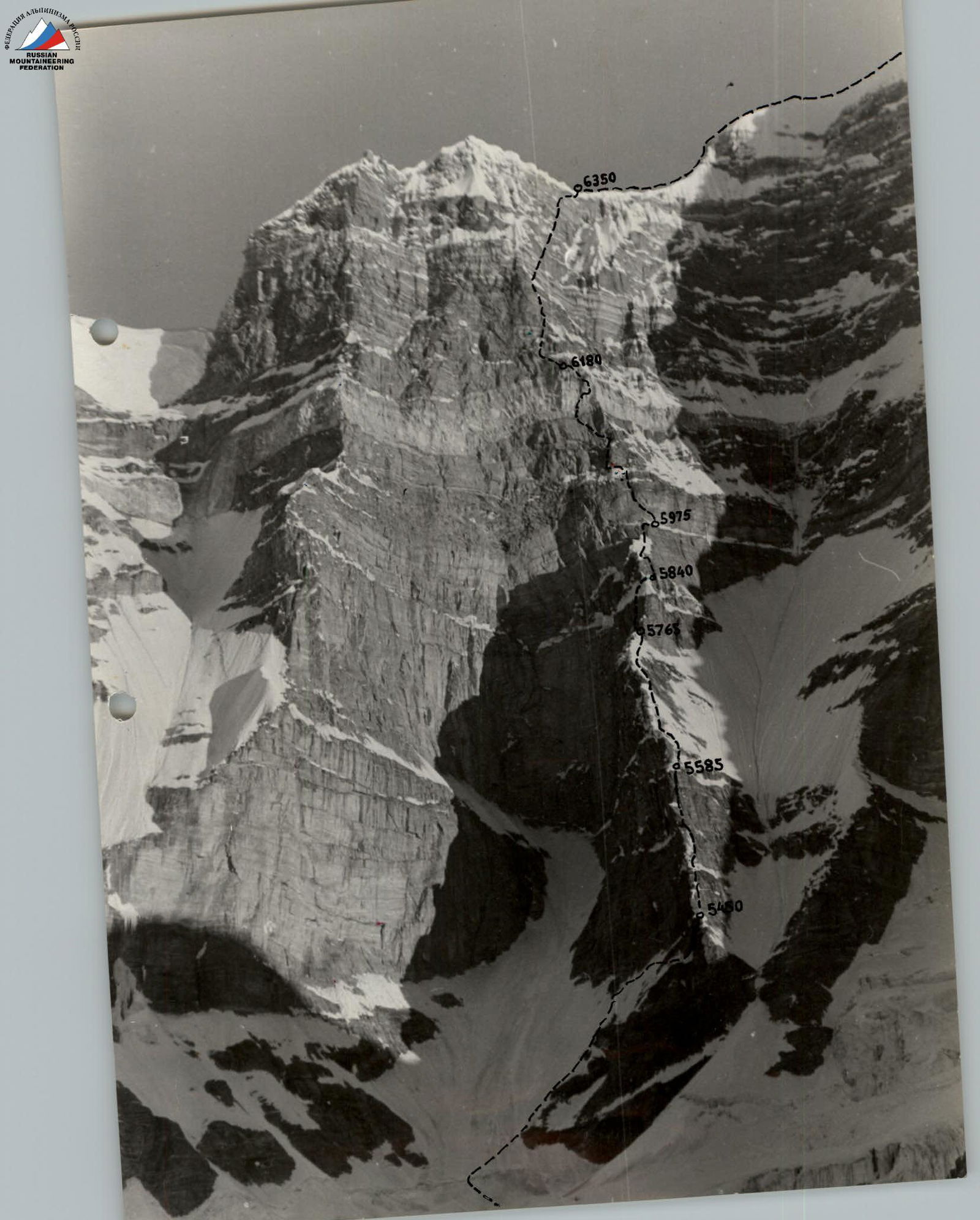
The route is logical and safe throughout. The overall steepness of the wall is more than 75°, the length is 1600 m, the height difference from the beginning of the wall to the pre-summit ridge is 1300 m. The steepness of the wall in the descent contains several snow-ice sections, which differ in their special snow and ice (voids, cal-gospores).
The average steepness of the rock sections is more than 80°, and the upper part of the wall is more than 85°. The route is replete with a variety of rock relief: walls, chimneys, cornices, gutters, inner corners, etc. There are dry and wet rocks, as well as those covered with rime ice.
The route is of great interest to athletes with rock climbing experience. The large length and significant height place high demands on the physical fitness of participants.
In total, the team spent 115 working hours to complete the route. 228 rock pitons and 34 ice pitons were driven.
Comparing the route on the southern wall of Peak Engels with other routes of a similar class passed by the team members: Peak Revolyutsii (along Myshlyaev's route), Peak Khan-Tengri (along the marble edge), Peak Tajikistan (along the route of KBA BSSR), we can say that it exceeds them in complexity. The upper part of the route is quite comparable to routes of the alpine type, such as:
- Western wall of Petit Dru
- Wall of Grand Joras
- North wall of Shitya.
In view of the above, the group believes that the route вполне corresponds 6B cat. sl.
Table of main characteristics of the ascent route
- Ascent route: To Peak Engels along the southern wall
- Height difference of the route: From the Kishty-Djero glacier to the summit - 1660 m
- Including the most difficult sections - 1300 m
- Steepness of the route: 75°
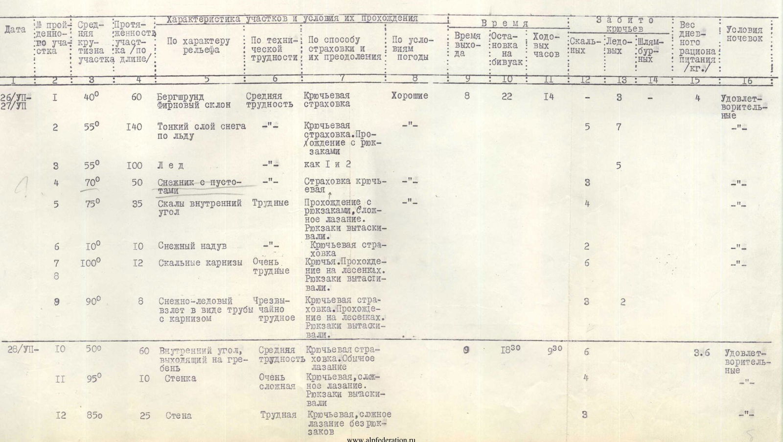
| Date | Section № | Section steepness | Section length (m) | Relief character | Technical difficulty | Insurance and overcoming method | Weather conditions | Exit time | Stop at bivouac | Working hours | Rock pitons | Ice pitons | Piton-jammer | Daily food ration weight (kg) | Overnight stay conditions |
|---|---|---|---|---|---|---|---|---|---|---|---|---|---|---|---|
| 26/VII– | 1 | 40° | 60 | Bergschrund, firn slope | Medium difficulty | Piton insurance | Good | 8:00 | 22:30 | 14 | 3 | 4 | Satisfactory | ||
| 27/VII | 2 | 55° | 140 | Thin layer of snow on ice | Piton insurance. Passing with backpacks | 5 | 7 | —"— | |||||||
| 3 | 55° | 100 | Ice | As 1 and 2 | 5 | —"— | |||||||||
| 4 | 70° | 50 | Snowfield with voids | Piton insurance | 3 | —"— | |||||||||
| 5 | 75° | 35 | Rocks, inner corner | Difficult | Passing with backpacks, difficult climbing. Backpacks were pulled out. | 4 | —"— | ||||||||
| 6 | 100° | 10 | Snow overhang | Piton insurance | 2 | —"— | |||||||||
| 7 | 100° | 12 | Rock cornices | Very difficult | Pitons. Passing on ladders. Backpacks were pulled out. | 6 | —"— | ||||||||
| 8 | |||||||||||||||
| 9 | 90° | 8 | Snow-ice ascent in the form of a pipe with a cornice | Extremely difficult | Piton insurance. Passing on ladders. Backpacks were pulled out. | 3 | 2 | —"— | |||||||
| 28/VII– | 10 | 50° | 60 | Inner corner exiting to the ridge | Medium difficulty | Piton insurance. Normal climbing | 9:00 | 18:30 | 9:30 | 6 | 3,6 | Satisfactory | |||
| 11 | 95° | 10 | Wall | Very complex | Piton insurance, difficult climbing. Backpacks were pulled out. | 4 | —"— | ||||||||
| 12 | 85° | 25 | Wall | Difficult | Piton insurance, difficult climbing without backpacks. | 3 | —"— | ||||||||
| 28/VII | 13 | 80° | 45 | Wall | Difficult | Piton insurance, difficult climbing without backpacks. | Good | 5 | Satisfactory | ||||||
| 14 | 45° | 20 | Wall | Complex | Piton insurance, difficult climbing | 8 | —"— | ||||||||
| 15 | 80° | 20 | Walls with small holds | Extremely difficult | Piton insurance, passing on ladders without backpacks. | 9 | —"— | ||||||||
| 16 | |||||||||||||||
| 17 | 1 | —"— | |||||||||||||
| 18 | 35° | 20 | Sharp snowy ridge | Medium difficulty | Insurance through ice axe, movement in rope teams. | —"— | |||||||||
| 29/VII | 19 | 80° | 25 | Inner corner | Complex | Pitons, difficult climbing. | Good | 9:00 | 18:30 | 9:30 | 3 | 1 | 3,6 | Satisfactory | |
| 20 | 50° | 100 | Snow-ice slope | Medium difficulty | Insurance through ice axe, pitons, movement in rope teams. | 12 | —"— | ||||||||
| 21 | 90° | 17 | Wall with small and no holds | Extremely complex | Pitons, passing on ladders without backpacks. | 3 | —"— | ||||||||
| 22 | 50° | 100 | Snow slope | Medium difficulty | Insurance through ice axe. Movement along handrails. | 4 | —"— | ||||||||
| 30/VII | 23 | 85° | 15 | Chimneys, crevices with wet rocks | Very difficult | Pitons, difficult climbing. | Good | 9:15 | 21:00 | 11:45 | 3 | 3,6 | Bad | ||
| 24 | 85° | 60 | Wall with cornices without holds | Extremely complex | Pitons, extreme climbing on ladders without backpacks. | 20 | —"— | ||||||||
| 25 | 75° | 40 | Snow slope with crumbly snow | Complex | Pitons, ice axe, movement along handrails. | 3 | 2 | —"— | |||||||
| 26 | 75° | 12 | Wall with small holds | Complex | Pitons, difficult climbing. | 3 | —"— | ||||||||
| 27 | 70° | 25 | Narrow talus couloir | Medium | Pitons, sport descent without backpacks. | 2 | —"— | ||||||||
| 31/VII | 28 | 85° | 40 | Wall with small holds | Complex | Pitons, difficult climbing without backpacks. | Good | 8:30 | 20:30 | 12 | 7 | 3,0 | Good | ||
| 29 | 55° | 100 | Wall | Complex | Pitons, difficult climbing. | 11 | —"— | ||||||||
| 30 | 85° | 40 | Wall with small holds | Very complex | Pitons, difficult climbing. | 7 | —"— | ||||||||
| 31 | 110° | 5 | Cornice without holds | Extremely complex | Pitons, passing on ladders without backpacks. | 3 | —"— |
| Date | Section № | Section steepness | Section length (m) | Relief character | Technical difficulty | Insurance and overcoming method | Weather conditions | Exit time | Stop at bivouac | Working hours | Rock pitons | Ice pitons | Piton-jammer | Daily food ration weight (kg) | Overnight stay conditions |
|---|---|---|---|---|---|---|---|---|---|---|---|---|---|---|---|
| 1/VIII | 32 | 85° | 120 | Wall with small cornices | Very complex | Pitons, difficult climbing without backpacks. | Good | 6:00 | 22:00 | 16 | 20 | 3,0 | Sitting overnight stay | ||
| 33 | 85° | 20 | Wall with a small cornice | Piton insurance, passing without backpacks. | 5 | —"— | |||||||||
| 34 | 100° | 80 | Marble belt with crevices, chimneys, cornices (wet rocks) | Extremely complex | Piton insurance, extreme climbing without backpacks. | 15 | —"— | ||||||||
| 2/VIII | 35 | 85° | 60 | Monolithic rocks | Very complex | Pitons, passing without backpacks. | Good | 5:30 | 21:30 | 16 | 12 | 3,0 | Good | ||
| 36 | 110° | 7 | Cornice with small holds | Extremely complex | Pitons, ladders, passing without backpacks. | 5:30 | 21:30 | 5 | —"— | ||||||
| 37 | 45° | 200 | Shelf with rime ice | Complex | Difficult climbing, pitons. | 18 | —"— | ||||||||
| 38 | 90° | 30 | 2 gutters with rime ice | Exceptionally complex | Pitons, ladders, passing with jammers without backpacks. | 9 | 4 | —"— | |||||||
| 39 | |||||||||||||||
| 40 | 110° | 5 | Snow cornice | Very complex | Ice axe, passing with jammers 1st on a "living ladder". | 3 | —"— | ||||||||
| 3/VIII | 41 | 40–75° | 120 | Ridge to the summit (snow, ice, rocks) | Medium, difficult | Ice axe, piton insurance, movement in rope teams. | 7:00 | 21:30 | 14:30 | 5 | 3,0 |
Descent from the summit to the saddle between Peaks Marx and Engels.