Appendix
to the Regulations on the USSR Championship in Alpinism for 1970
ASCENT DOCUMENTATION
of the ascent made in the 1970 USSR Alpinism Championship
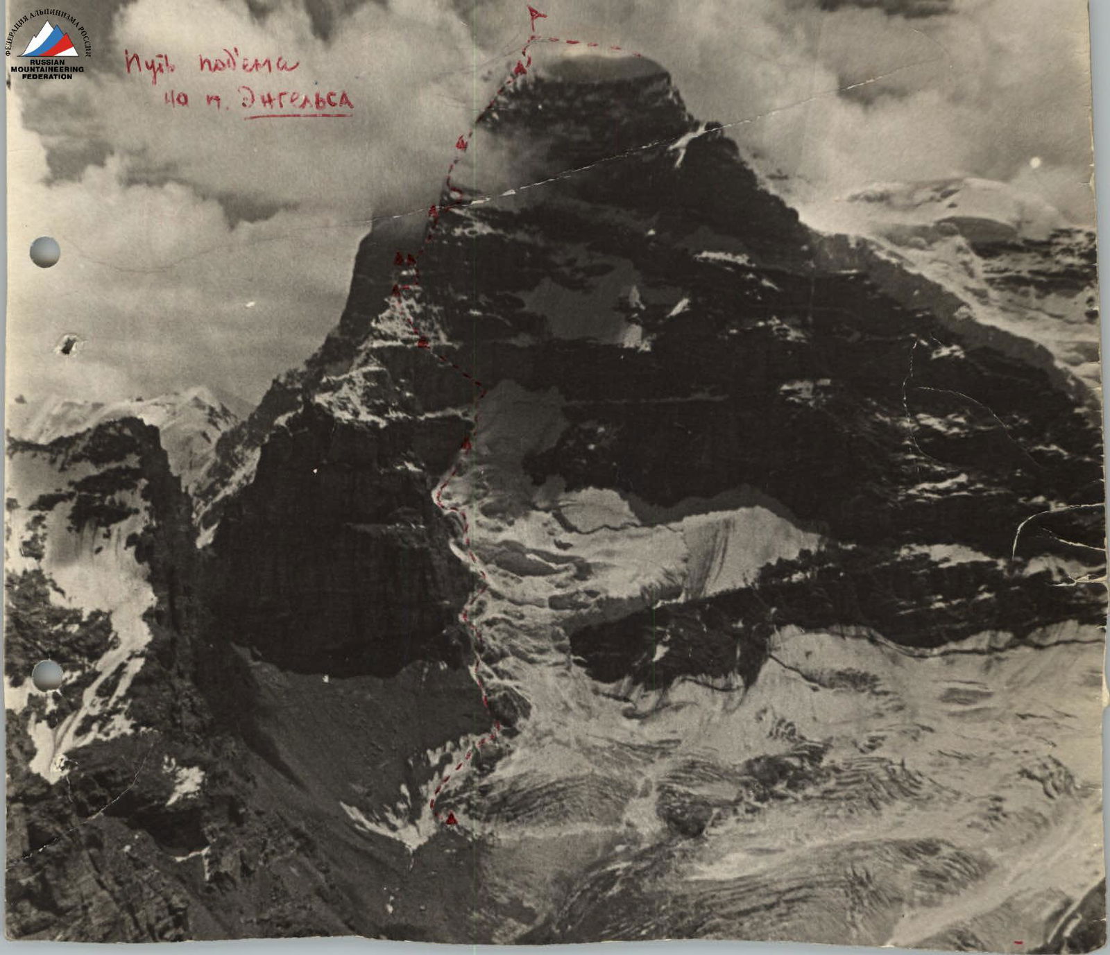
I. Ascent category: Traverse 2. Ascent area: Southwestern Pamir 3. Ascent route: with indication of peaks and their heights:
- Via the northern wall:
- Peak Engels 6510 m
- Peak Marx 6726 m
4. Ascent description:
- height difference: from the assault camp to the summit of Peak Engels 1710 m, from the col to the summit of Peak Marx 920 m.
- average slope: from 50° to 60° — 1000 m, from 70° to 90° — 490 m.
- length of difficult sections: 1490 m.
5. Number of pitons used:
- rock pitons 139
- ice pitons 45
- bolt pitons 40 6. Total climbing hours: 106 7. Number of bivouacs and their characteristics: 12, of which 7 were good, 4 were poor, and 1 was a sitting bivouac 8. Team name: MGS "Spartak" 9. Surname, first name, patronymic of the team captain and members, and their sports qualification:
- Oleg Abalakov, captain, Master of Sports
- Nikolai Shalpegin, Candidate for Master of Sports
- Yuri Piskulov, Candidate for Master of Sports
- Viktor Koprova, Candidate for Master of Sports
- Dmitry Filippov, Candidate for Master of Sports
- Pavel Zayd, Candidate for Master of Sports 10. Date of ascent: 1970, from July 23 to August 3. II. Place taken by the team:
Ascent Route via the Northern Wall of Peak Engels

6. Route Passage and Assessment of Participants' Actions
a) Ascent
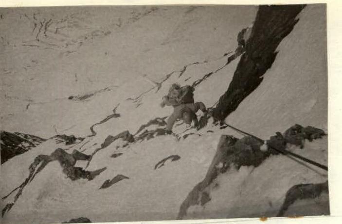
July 22. The weather has finally stabilized, and the ascent is scheduled for the morning of July 23. At 7:00, the group quickly gathers and begins moving from the assault camp at 4800 m towards the glacier under the northern wall. The glacier is broken by crevasses, which can only be navigated near the rocks. The pre-scouted path allows for quick selection of the safest route. The initial part of the ascent presents no significant difficulties due to the snow that has hardened overnight. As we ascend:
- the snow lies less securely,
- we have to organize belays, sometimes using an ice axe,
- on steep sections, we hammer in ice pitons.
The slope becomes steeper, and we restore steps that had melted during the reconnaissance. The rate of ascent is significant because we need to pass a section near the rockslide-prone right rock edge before sunrise.
The cache is located on a steep snowy slope under an overhanging rock. Next, we need to move across an unprotected snowy field where dry avalanches are already flowing. Although it's only 1:00 PM, we decide to bivouac at the cache site.
We have to dig deep hollows in the ice to set up tents. With plenty of free time, we settle in well for a lying-down bivouac by evening.
July 24, 1970
- Departure at 7:00 AM.
- Previously trodden steps were covered in snow due to constantly falling dry snow.
- With fresh strength, we quickly overcome the steep slope, which leads to another gap.
- To cross the gap, we have to navigate a short ice wall with piton belays.
- We proceed cautiously as the ice and rocks are covered in unreliable snow.
After overcoming several rock walls and ice sections of 10–15 m, we reach the beginning of a narrow rock ledge. The ice cone (which took about 3 hours to overcome) blocks the ledge and is traversed on the middle part using toe holds. Belays are organized:
- first using rock pitons,
- then ice pitons.
After passing one rope length beyond the cone, we set up a bivouac as the sun-exposed snow has softened, and any movement triggers avalanches. We settle on a steep snow-ice ledge under a rock overhang that protects us from avalanches. Organizing the bivouac again takes a lot of effort and time; we have to dig into the ice.
July 25. Early in the morning, we continue our movement. From here, the first ascenders went left — up to the ridge; we, however, due to avalanche danger, moved more to the right, almost straight up, along rock islands, sometimes stepping onto these rocks to bypass steep ice walls. The belay is piton-based (there are many suitable cracks in the rocks).
After passing steep rocks that continue the first rock belt, we reach the ridge and set up camp on a small saddle. While the platforms are being prepared, the pair Abalakov–Zayd processes a section of the rocky ridge above the bivouac.
July 26. The weather is good in the morning. We quickly gather and start moving. At 9:00, the group is already on the route. After passing the processed section, we begin a complex bypass of an overhanging gendarme from the right. Two rope lengths of complex traversing lead us under an iced wall with an ice chimney; it is traversed using artificial holds and thorough piton belays. The ridge is close, but we have to overcome a difficult wall that requires the use of bolt pitons and a platform before we can reach a snow-ice slope leading to the ridge rocks. There are several places in these rocks where vertical crevices allow us to climb up to the col before the second granite belt without much difficulty. We spend the rest of the day studying the smooth monoliths towering above the col on an almost 100-meter wall.
The col offers an excellent bivouac.
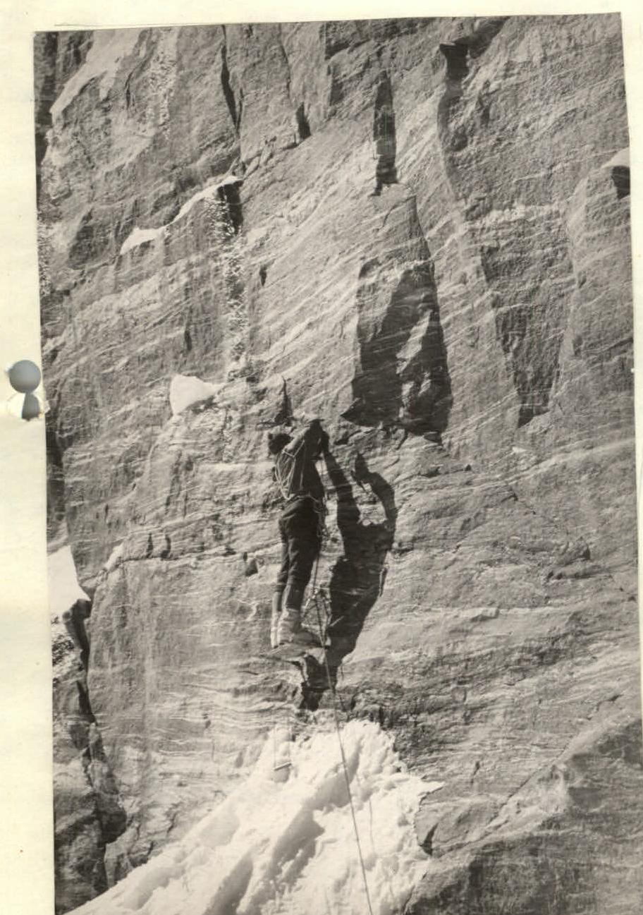
July 27. A thorough inspection of the wall convinces us that following the first ascenders' route is impossible because all the cracks and holds in the angle formed by the sheer walls are covered in rime ice; moreover, ice chunks frequently fall. We decide to move up the center of the sheer face of this "three-tiered" bastion, which overhangs the ridge.
The pair Abalakov–Shalpegin, armed with drills, ladders, and a platform, starts processing the route. The path goes straight up. 15 bolt pitons (1.2 m apart) lead to a short, steep ledge. The pairs switch. After passing the processed section on "artificial holds," another 10–12 m are processed by the pair Piskulov–Koprova.
The working day is over; we can rest.
July 28. In the morning, the first pair quickly passes the previously processed sheer faces and continues the bolt work. The rock here is worse, flaking off in small pieces, so we have to chip them off first. To the left, at the exit from the angle, we find two bolt pitons from the Budalov group — a pleasant discovery. After driving in 10 bolt pitons, we reach a steep snowy slope leading to a rock wall. There are no suitable places for tents. We settle on a 30° slab covered in rime ice, tie ourselves in, and spend the night.
July 29. Departure at 9:00 AM. The morning is cloudy.
The first ascenders went right along the ledges, but the tracks of avalanches and falling stones indicate that it's risky to go that way now.
We examine the path up to the ridge:
- To the left along the ledges — the exit is not difficult, but after one rope length of easy climbing along the ridge, we'll have to overcome a 40-meter sheer face without cracks. This is at least half a day of bolt work.
- To the right, the sheer face is dissected by a chimney and several cracks, forming a very effective slab-type wall. Although this section is longer than the ridge route (80 m), it can still be climbed using pitons and ladders.
We decide on this path, which leads:
- First, vertically up along a crack.
- Then, a slab that has separated from the wall allows us to gain another 10 m to the left — up.
- Then — again along a vertical crack under a ledge that blocks further ascent.
- From here — a 3–4 m pendulum to the left, into the base of an 8-meter steep chimney, the middle part of which is blocked by a plug.
For belays and additional holds, rock pitons are used. The plug is climbed from the right, outside, with the use of auxiliary pitons. Then — again a difficult passage to the right for 2 m and then straight up for 4 m.
After passing this section, Abalakov hangs a rope down to the ledge. We pull up backpacks using this rope. The other pairs pass this section by climbing and using "artificial holds"; however, movement on the sheer faces and pulling up backpacks take a lot of time and effort.
Already in the dark, after passing more straightforward rocks for another rope length, we reach a steep ice-snow ridge. We manage to carve out two small platforms and, organizing belays with ice pitons, climb into our bags, cover ourselves with tents, and fall into a light sleep.
July 30. In the morning, we take a long time to gather; the altitude and the previous day's fatigue are taking their toll, and the small platforms make it hard to move around. It's cold. The ridge is very steep; we climb using crampons. Our feet are freezing.
At the beginning of the path, small rock outcrops allowed us to organize belays using rock pitons, but then a steep ice climb (two rope lengths) forces us to cut steps and use ice pitons.
After the climb, the ridge becomes somewhat gentler, but we're still far from the summit. We come to the conclusion that the first ascenders must have exited the wall somewhere around here, bypassing this section along the ledges.
We pass several rope lengths along the ridge — it's steep, and the snow is loose. We have to find places for belays. Typically, these are:
- bends where fresh snow is blown away.
Some areas are dangerous due to hidden crevasses that dissect the ridge and open onto the northeastern wall.
The northern wall of Peak Engels ends and transitions into a steep snow-ice slope. 100 m from the edge of the rocks, we begin a traverse to the right towards a standalone overhanging rock. It's 4:00 PM; it seems we could reach the summit, but our strength is waning, and to avoid spending the night on the bare summit dome, we decide to stop under the rock's overhang. Here, there are almost flat platforms, and after 1.5 hours of preparation, we can set up tents. After the last two uncomfortable nights, we sleep soundly despite the altitude.
July 31. 10:00 AM. It's cold. We bypass the rock that sheltered us to the right and start moving up in crampons. The snow is firm; we use ice axe belays.
The first two rope lengths are steep, then the slope gradually flattens, and we finally reach the ridge leading left to the summit.
We reach the highest point. There's no cairn; only a broken ice axe remains. We remove it, but there's no note under it either. We attach our note to the axe handle and secure it firmly in the dense snow.
Then, we begin our descent along the gentle ridge leading towards Peak 40 Years of VLKSM. To avoid the slopes of "40 Years," we move along the right rocky ridge instead of the left one. A few sports moves — and we reach the horizontal part of this ridge. From here, we start descending along a steep rocky-ice couloir onto the plateau. Three rope lengths of descent along the rocks — we reach a steep snowy slope that leads onto the plateau under Peak 40 Years of VLKSM. It's already evening; we're tired; we set up a bivouac and fall asleep quickly.
August 1. In the morning, we gather without haste. Today, we're supposed to descend to the col of Marx. Reconnaissance during preparation showed the principal possibility of descending around the ridge from Peak 40 Years of VLKSM, exiting in the lower part, but now a more detailed reconnaissance is necessary. The pair Abalakov–Shalpegin goes ahead, agreeing to signal with a flare as soon as they determine the route is passable.
First, we descend down the icefall (we're wearing crampons) with variable belays. We reach steep ice drops. There's no way down; we have to start traversing left towards a clearly visible ridge. We move along the left lateral slopes under the rocks. The slopes are steep; we have to constantly cut steps. 4 hours of work, six rope lengths — and we're on the ridge. Along the ridge, there's несложное lazing, snow and rocks; we descend another three rope lengths and down a couloir to the left — onto the col's plateau.
We cross the plateau towards Peak Marx and stop under the slope for the night. In the morning, there's fog, but we can't delay. Most of the group has climbed Peak Marx via this route before, so choosing the route doesn't pose a challenge.
August 2. We leave the bivouac at 9:00 AM. The weather is good. The group quickly gains altitude, navigating rocky-ice ascents in crampons. By noon, the slopes of Marx are shrouded in fog; visibility decreases; a low-lying cloud begins. We find a safe place under a ledge of the glacier, set up a bivouac. The weather hasn't improved by evening. We've covered about half the distance to the summit.
August 3. We depart early. The bright sun is shining. However, dark clouds to the north don't promise good weather. The general direction is to the right, bypassing the drops, towards an ice gully. The rate of ascent is high.
The ascent along the ice gully is challenging; the ice is almost smooth. We move on the front points of our crampons, carefully belaying each other. The ice gully is the most dangerous part of the ascent to Peak Marx.
After it, we immediately move right along steep ice and, traversing the ice drops to the right, reach a not clearly defined snowy ridge. The movement is monotonous and tiring:
- along the way, we encounter several crevasses over snow bridges;
- the snow is poorly firmed, crumbling down in lumps;
- we have to repeatedly firm up the steps;
- we frequently change the lead.
The fog intensifies. By 10:00 AM, the sun is finally hidden in thick fog; visibility is limited to the extreme.
Further movement along the ridge is extremely difficult due to numerous crevasses. We move up to the left. The ice is steep, and the snow has poor adhesion to the slope. We carefully watch over each other and approach an ice drop, along which we move to the left. Then, we go vertically up along steep ice and approach an ice barrier. We can't overcome the barrier; we bypass it up and to the right. Finding a depression in the barrier, we climb on the front points of our crampons and, following short firn ascents, reach a broad pre-summit ridge. We move simultaneously. We reach the summit at 12:00 and, after a short rest, following the ascent route and then descending into the Lyan-gar valley, begin our descent.
b) Assessment of the actions of the group participants and the order of movement
All participants in the ascent demonstrated themselves to be highly qualified and physically fit alpinists.
During the ascent, a certain specialization of the pairs was developed, allowing for the most effective use of each participant's strengths.
The leading pair: Abalakov–Shalpegin
The second pair: Zayd–Filippov, worked on pulling up backpacks.
The third pair: Piskulov–Koprov assisted the second pair and extracted pitons.
All participants in the assault group made a significant contribution to the passage of this interesting and complex route, which undoubtedly deserves the rating given to it by the first ascenders in 1964 as a 6B category route.
The support group consisted of three people:
- Polyakov — Master of Sports
- Brekhovskikh — 1st sports category
- Parfenov — 1st sports category
- Vasiliev — doctor
The assault group had two-way radio communication with the support group twice a day.
Team captain (O. Abalakov)
Appendices:
- Characteristics of sections and conditions of their passage.
- Scheme of route passage.
- Photographs of key sections of the wall.
- Ascent documentation.
Traverse along ledges bypassing the gendarme after the third section
Start of movement along the first wall of the second rock belt.
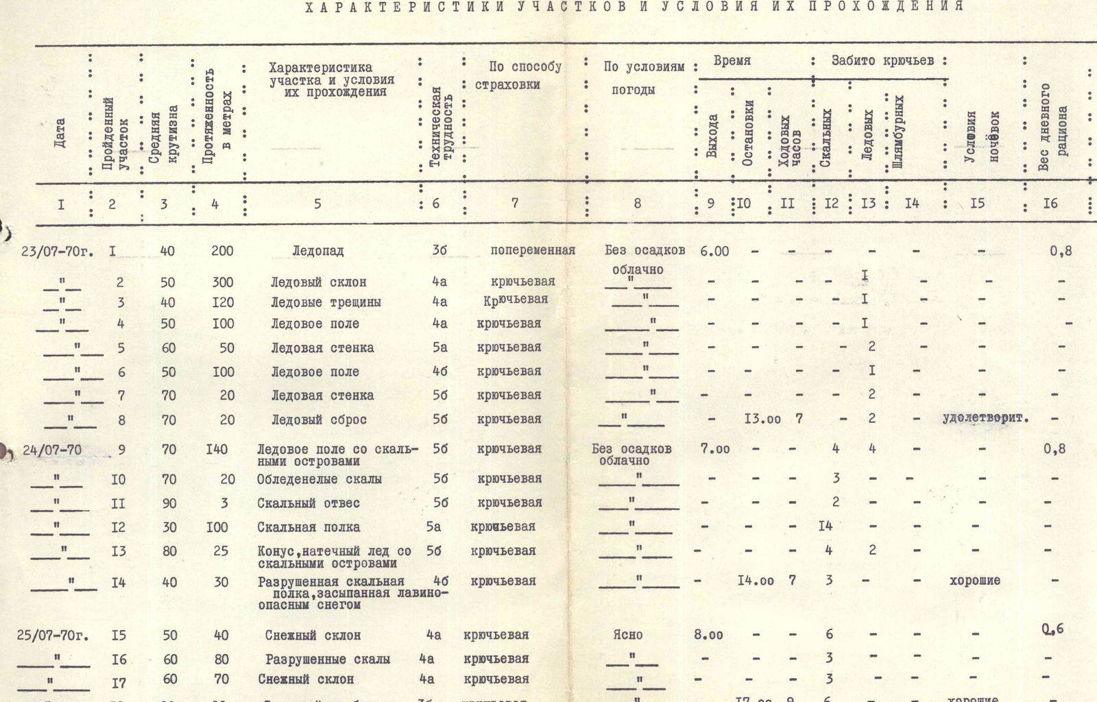
Characteristics of sections and conditions of their passage
| Date | №R | Steepness (°) | Length (m) | Description of the section and conditions of its passage | Tech. diff. | Method of belay | Weather | Departure | Stops | Climbing hours | Rock pitons | Ice pitons | Bolt pitons | Bivouac conditions | Ration weight (kg) |
|---|---|---|---|---|---|---|---|---|---|---|---|---|---|---|---|
| July 23, 1970 | R1 | 40 | 200 | Icefall | 3 | alternating | No precipitation, cloudy | 6:00 | 0.8 | ||||||
| R2 | 50 | 300 | Ice slope | 4 | piton belay | " | 1 | ||||||||
| R3 | 40 | 120 | Ice crevasses | 4 | piton belay | " | 1 | ||||||||
| R4 | 50 | 100 | Ice field | 4 | piton belay | " | 1 | ||||||||
| R5 | 60 | 50 | Ice wall | 5 | piton belay | " | 2 | ||||||||
| R6 | 50 | 100 | Ice field | 4 | piton belay | " | 1 | ||||||||
| R7 | 70 | 20 | Ice wall | 5 | piton belay | " | 2 | ||||||||
| R8 | 70 | 20 | Ice drop | 5 | piton belay | " | 13:00 | 7 | 2 | satisfactory | |||||
| July 24, 1970 | R9 | 70 | 140 | Ice field with rock islands | 5 | piton belay | No precipitation, cloudy | 7:00 | 4 | 4 | 0.8 | ||||
| R10 | 70 | 20 | Icy rocks | 5 | piton belay | " | 3 | ||||||||
| R11 | 90 | 3 | Rock sheer face | 5 | piton belay | " | 2 | ||||||||
| R12 | 30 | 100 | Rock ledge | 5 | piton belay | " | 14 | ||||||||
| R13 | 80 | 25 | Cone, rime ice with rock islands | 5 | piton belay | " | 4 | 2 | |||||||
| R14 | 40 | 30 | Destroyed rock ledge covered in avalanche-prone snow | 4 | piton belay | " | 14:00 | 7 | 3 | good | |||||
| July 25, 1970 | R15 | 50 | 40 | Snow slope | 4 | piton belay | Clear | 8:00 | 6 | 0.6 | |||||
| R16 | 60 | 80 | Destroyed rocks | 4 | piton belay | " | 3 | ||||||||
| R17 | 60 | 70 | Snow slope | 4 | piton belay | " | 3 | ||||||||
| R18 | 20 | 20 | Rock ridge | 3 | piton belay | " | 17:00 | 9 | 6 | good | |||||
| July 26, 1970 | R19 | 80 | 35 | Slab-wall | 5 | piton belay | clear | 9:00 | 0.6 | ||||||
| R20 | 30 | 50 | Traverse under the wall | 4 | piton belay | " | |||||||||
| R21 | 70 | 30 | Rock chimney | 5 | piton belay | " | |||||||||
| R22 | 90 | 15 | Vertical wall | 6 | piton belay | " | 1 | 5 | |||||||
| R23 | 70 | 20 | Monolithic rocks | 5 | piton belay | " | |||||||||
| R24 | 60 | 35 | Snow-ice slope | 5 | piton belay | " | 1 | ||||||||
| R25 | 70 | 5 | Rock chimney | 5 | piton belay | " | 16:00 | 7 | 2 | good | |||||
| July 27, 1970 | R26 | 90 | 30 | Monolithic rock wall | 6 | piton belay | clear | 9:00 | 3 | 15 | 0.6 | ||||
| R27 | 70 | 10 | Slab | 5 | piton belay | " | 18:00 | 9 | 2 | excellent | |||||
| July 28, 1970 | R28 | 90 | 30 | Monolithic rock wall | 6 | piton belay | clear | 9:00 | 21:00 | 12 | 4 | 13 | poor | 0.6 | |
| July 29, 1970 | R29 | 80 | 20 | Rocks with block structure | 5 | piton belay | clear | 9:00 | 6 | ||||||
| R30 | 60 | 70 | 4 | piton belay | " | 6 | 0.6 | ||||||||
| R31 | 40 | 60 | Traverse under the wall | 4 | piton belay | " | 4 | ||||||||
| R32 | 70 | 10 | Icy rocks | 5 | piton belay | " | 2 | ||||||||
| R33 | 50 | 80 | Snow-ice slope with icy rock islands | 5 | piton belay | clear | 2 | 1 | |||||||
| R34 | 60 | 40 | Stepped rocks | 4 | piton belay | " | 3 | ||||||||
| R35 | 80 | 10 | Wall/rock wall | 5 | piton belay | " | 1 | ||||||||
| R36 | 60 | 35 | Stepped rocks | 5 | piton belay | " | 2 | ||||||||
| R37 | 90 | 8 | Start of chimney | 6 | piton belay | " | 2 | 1 | |||||||
| R38 | 80 | 12 | Slab | 5 | piton belay | " | 3 | 1 | |||||||
| R39 | 90 | 20 | Crevice with a plug | 6 | piton belay | " | 6 | 3 | |||||||
| R40 | 70 | 35 | Destroyed rocks with rime ice | 5 | piton belay | " | 21:00 | 12 | 8 | poor | |||||
| July 30, 1970 | R41 | 60 | 60 | Snow-ice slope | 5 | alternating and piton belay | frost | 9:30 | 2 | 0.4 | |||||
| R42 | 45 | 200 | Snow-ice slope | 5 | alternating | " | 15:30 | 6 | good | ||||||
| July 31, 1970 | R43 | 40 | 15 | Rock outcrop | 4 | alternating | " | 10:00 | |||||||
| R44 | 50 | 130 | Pre-summit dome (snow, firn) | 5 | alternating | frost | |||||||||
| R45 | 20 | 20 | Firn slope. Summit | 2 | simultaneous | " | |||||||||
| R46 | 30 | 200 | Descent along snow-firn ridge | 4 | alternating | " | |||||||||
| R47 | 60 | 400 | Descent along destroyed rocks of the ridge | 5 | piton belay | " | 8 | ||||||||
| R48 | 50 | 160 | Descent from the ridge along an ice slope — couloir | 4 | piton belay | " | 6 | 1 | |||||||
| R49 | 30 | 150 | Descent along firn and snow | 3 | alternating | " | |||||||||
| R50 | 20 | 3 | Ice crevasse | 3 | " | " | |||||||||
| R51 | 20 | 200 | Descent along snow | 2 | simultaneous | " | |||||||||
| R52 | 10 | 20 | Col between "Engels" and "40 Years of VLKSM" | 2 | simultaneous | " | 17:00 | 7 | good | ||||||
| August 1, 1970 | R53 | 45 | 400 | Descent along firn | 3 | simultaneous | clear | ||||||||
| R54 | 50 | 250 | Ice slope | 5 | alternating | fog, graupel | 10 | ||||||||
| R55 | 30 | 120 | Descent along rocky ridge | 3 | simultaneous | " | |||||||||
| R56 | 30 | 200 | Snow slope | 3 | alternating | clear | good | 0.8 | |||||||
| R57 | 30 | 130 | Snow-ice slope | 4 | alternating | fog, graupel | 9:00 | 0.8 | |||||||
| R58 | 30 | 200 | Snow slope | 3 | " | 12:00 | 3 | ||||||||
| R59 | 30 | 200 | Snow slope | 3 | clear | 14:00 | 0.6 | ||||||||
| R60 | 60 | 40 | Ice gully | 5 | piton belay | " | 2 | ||||||||
| R61 | 50 | 80 | Ice slope | 5 | " | " | 3 | ||||||||
| R62 | 30 | 40 | Ice slope | 5 | " | " | 1 | ||||||||
| R63 | 50 | 250 | Snow ridge | 5 | alternating | clear | 19:00 | 10 | good | ||||||
| August 3, 1970 | R64 | 50 | 100 | Firn slope | 5 | alternating | clear | 0.6 | |||||||
| R65 | 40 | 40 | Ice slope | 5 | piton belay | " | 3 | ||||||||
| R66 | 55 | 100 | Ice-firn slope | 5 | piton belay | " | 4 | ||||||||
| R67 | 60 | 20 | Ice | 5 | piton belay | " | 1 | good |