Report
on the traverse of peaks Engel'sa — Marx — Shakdarinsky Ridge — Pamir (first ascent).
1. Geographical Location and Sporting Characteristics of Peaks Engel'sa and Marx
a) Geography of the Area.
Both peaks are located in the Shakdarinsky Ridge, stretching in a latitudinal direction, and are its highest peaks.
- Height of peak Marx — 6726 m.
- Height of peak Engel'sa — 6510 m.
The Shakdarinsky Ridge is a watershed between the Pyanj River basin (to the south) and the Shakdara River basin (to the north). Lateral ridges extending from the arrays of peaks Marx and Engel'sa divide the northern slopes into three valleys: Khatsak, Shaboy, and Nispar (from west to east). Thus, both peaks are accessible from the north only from the Shaboy valley.
Here, both peaks drop with huge walls to the foot of the Marx Glacier. The peak arrays rest on granite foundations, resulting in exceptionally extensive sections of sheer walls and a blocky rock structure. Individual monolithic blocks in the array of peak Engel'sa reach 500 m.
The slopes of the ridge are covered with powerful glaciation, and numerous ice falls are present, especially in the area between peaks Marx and Engel'sa. However, the relief of the Marx Glacier does not contain significant difficulties. The slopes of peaks Marx and Engel'sa from the north represent routes of the highest category of difficulty, but ascent by these paths is possible only after thorough reconnaissance.
Lateral ridges bounding the Shaboy valley to the east and west are significantly lower (5200 m, 5400 m) and do not carry significant glaciation. Routes to individual peaks are not higher than category 4. Ascending the walls (mainly from the east) is impossible due to the exceptional disintegration of rocks.
b) History of Alpine Exploration.
Unlike the southern slopes of the area around peaks Marx and Engel'sa, visited by climbers in 1954 (expedition of the Georgian Alpine Club led by O. Gigineishvili), in 1958, an expedition of the Moscow Regional Council of the "Trud" Sports Society led by V. Tikhonravov, in 1961 and 1962, expeditions of the Leningrad Regional Council of the "Burevestnik" Sports Society led by S. Savvon, and in 1963, an expedition of the sports club of the army led by Nekrasov, from the north, the area around peaks Marx and Engel'sa was visited by only two expeditions before 1964.
In 1946, an expedition of the All-Union Council of Physical Culture and Sports led by E. Abalakova entered the Shaboy valley and made the first ascent of peak Marx, and in 1961, an expedition of the Central Council of the "Spartak" Sports Society led by V. Kizel made several ascents in the Khatsak valley.
The most significant contribution to the study of the area's orography was made by expeditions of the Leningrad Regional Council of the "Burevestnik" Sports Society. In particular, they clarified:
- the relative positions of peaks Marx and Nikoladze (6350 m);
- the overall layout of the adjacent ridges.
2. Conditions for the Traverse
a) Relief.
A characteristic feature of the structure of the arrays of peaks Engel'sa and Marx is the blocky structure of rocks, and:
- when ascending to peak Engel'sa and peak Marx, the slope steepness is much greater than during descents,
- the traverse is from east to west.
Significant overhangs are encountered in some areas. Granite ledges do not have holds or grips. There are few cracks for driving in pitons.
The exit to the northern edge of peak Engel'sa presents significant difficulty.
The saddle between the "5800 m" peak and peak Engel'sa faces the Shaboy valley with a smooth ledge and is under fire from stones from the "5800 m" peak.
Exceptionally extensive overhangs (up to 120 m) located on the ridge immediately after the saddle do not allow for ascent from the saddle.
Parallel to the ridge, but to the right of it, a steep, crevassed glacier rises towards the peak. It is bounded on the right and left by sheer half-kilometer walls. However, in the upper part of the glacier on the left wall (in the direction of travel), there is a narrow ledge leading under the ridge. This variant of exit to the ridge is safer: a significant part of the path is traversed under a rock overhang.
The transition from the wall to the ridge is relatively easy. However, movement along the ridge, as one approaches the second granite belt, becomes significantly more challenging.
At an altitude of 5800 m, the slopes are entirely covered with serac ice. Overcoming the second granite belt presents exceptional difficulty due to:
- the small number of cracks for pitons,
- the steepness of the slope.
Further movement along the ridge leads to steep rocks at the foot of a pinnacle. To overcome the pinnacles on the ridge, it is necessary to move right onto the northern wall.
At an altitude of 6200 m, the wall becomes exceptionally difficult; however, movement along the ridge here is completely impossible due to huge cornices hanging from the steep, disintegrated rocks into the Nispar valley.
The pre-summit ridge begins at an altitude of 6350 m, has significant steepness, but dense firn allows for reliable belaying through an ice axe.
The descent path from the summit is a category 5A route and was traversed in 1954, 1963, and 1964 by four groups. The difficulty of this route is significantly less compared to the ascent.
The ascent route to peak Marx is snow-ice. The texture of the snow cover is unfavorable:
- in the lower part of the wall, the ice is covered with a thin crust of snow,
- in the upper part of the wall, the snow is poorly firned and has relatively weak adhesion to the ice.
This circumstance, as well as a significant number of ice falls, does not allow for a straightforward ascent to peak Marx.
- In the lower part, an detour of ice falls was made to the left (in the direction of travel) under the edge of peak Nikoladze.
- In the upper part, a traverse to the left was made onto the ridge between peaks Nikoladze and Marx.
To ensure safety, the ascent was conducted along the right part of the ice wall along a barely expressed ridge up to an altitude of 6300 m.
The descent path from the summit of peak Marx, following the route of the first ascenders, does not present significant difficulties.
b) Weather.
The average daily temperature in the Shakdara basin (Jhushangos weather station) at an altitude of 3400 m in August 1964 was 13 °C. In the base camp at an altitude of 4000 m, snow fell multiple times. Especially heavy snowfalls occurred from July 27 to August 4. During the ascent from August 10 to 24, it was clear, except on August 16 and 21, when there was significant cloud cover and snowfall. The prevailing wind direction in the sector was from northwest to southwest.
c) Remoteness from Settlements. Exploration of the Area.
The area where the expedition took place is significantly remote from the main highway of the Pamir, Osh — Khorog. Currently, the shortest road to Khorog is being built along the Shakdara River valley.
The expedition's route from Dushanbe through:
- Kalai-Khumb,
- Khorog,
- Jlyandy along the road to the Jhushangos weather station, with a total length of 800 km, took 4 hours.
In the upper reaches of the Shaboy valley, the expedition moved with a pack caravan. The base camp was located 22 km from the weather station.
The orographic scheme of the Shakdarinsky Ridge in the area around peaks Marx and Engel'sa, given in D.M. Zatulovsky's book "Among Snow and Rocks," has several inaccuracies, such as:
- the "5800 m" peak in the lateral spur extending north from peak Engel'sa is not indicated;
- the morphology of the Marx Glacier is indicated incorrectly.
3. Reconnaissance and Logistics
a) From July 23 to August 4:
- the assault and auxiliary groups organized camps "4000" and "4800";
- G. Agranovskii's group made a logistics drop to the saddle between peaks Marx and Engel'sa from the south from the Kish-Dzharob valley;
- Rudanov's group ascended an unnamed "5800 m" peak to clarify the ascent route to peak Engel'sa and then climbed to the upper reaches of the glacier under peak Engel'sa to an altitude of 5600 m.
b) From August 5 to 7, a group of 9 people led by K. Konoplev ascended via the route of the first ascenders from the Nishgar pass to peak Marx and made a logistics drop.
Thus, by the start of the assault under the northern edge of peak Engel'sa at an altitude of 5600 m:
- logistics caches were established on the summit of peak Marx and on the saddle with a total weight of over 90 kg;
- the ascent route to peak Engel'sa from the north was reconned;
- the descent route from peak Engel'sa and the ascent route to peak Marx from the saddle were reconned;
- the descent route from peak Marx was traversed (during an acclimatization ascent);
- additional observations were conducted on the planned ascent route to determine the risk of rockfall or ice avalanches.
4. Ascent Plan and Tactical Methods
Since the traverse of peaks Marx and Engel'sa is a high-altitude traverse and the passage of individual sections presents significant technical difficulties, the tactical plan for the ascent was based on the team's experience accumulated in previous years:
- ascent of Mizhirgi via the northern wall in 1961 (Caucasus, technically complex);
- traverse of peaks Borodino — Leningrad in 1962 (Pamir, high-altitude traverse).
Most team members are prize-winners in competitions for the best alpine achievement in both technical and high-altitude ascent categories.
In the 1964 season, the group conducted a 10-day acclimatization training camp in the Caucasus.
Since the expedition of the Leningrad Regional Council of the "Spartak" Sports Society was part of the expedition of the Central Council of the "Spartak" Sports Society led by V. Abalakov, based to the south in the Kish-Dzharob valley, a system of continuous radio communication was established between both groups. Additionally, the timing of the groups' ascents was coordinated to ensure mutual support.
The ascent plan included:
- overcoming difficult rocks over a significant extent;
- navigating complex ice relief;
- identifying possible routes for emergency descents or providing assistance to those in distress.
For the ascent, the following new technical means were employed:
- titanium ice screws;
- lightweight carabiners;
- portable gas stoves;
- the group had a portable "Selga" receiver, allowing for weather information throughout the traverse.
5. Assault Group
a) Main Composition.
- Petr Petrovich Budanov — team captain, Master of Sports.
- German Leonidovich Agranovskii — deputy team captain, Honored Master of Sports.
- Yasén Vasil'evich D'yachenko — Master of Sports.
- Gennadii Yanovich Il'inskii — Honored Master of Sports.
- Boris Borisovich Kletsko — Master of Sports.
- Kirill Aleksandrovich Konoplev — 1st sports category.
- Viktor Andreevich Ovsyannikov — 1st sports category.
- Yurii Konstantinovich Ustinov — 1st sports category.
Most of the route was traversed by the group in the following rope team configurations:
- Budanov — Kletsko (Kletsko–D'yachenko)
- Konoplev — Ovsyannikov (Il'inskii–Ustinov–Konoplev)
- Ustinov — Il'inskii
- D'yachenko — Agranovskii (Budanov–Agranovskii)
Some sections were traversed in the rope team configurations indicated in parentheses.
Due to V. Ovsyannikov's illness, who descended from the saddle with the auxiliary group, the traverse was completed by seven participants.
b) Participant Information.
- Petr Petrovich Budanov — born 1920, Russian, non-party member, Master of Sports, alpine experience since 1946, resides: Leningrad, Tuchkov Lane, house 11, apartment 37.
Alpinism medals:
- 1954 — gold (traverse of Chatyn-Ushba-Mazeri);
- 1955 — silver (traverse of Muzhgilga-Sandol);
- 1955 — "silver" (peak Sandol);
- 1956 — gold (peak "Pobedy");
- 1959 — gold (peak Akhmati Donish);
- 1962 — bronze (traverse of peaks Borodino — Leningrad).
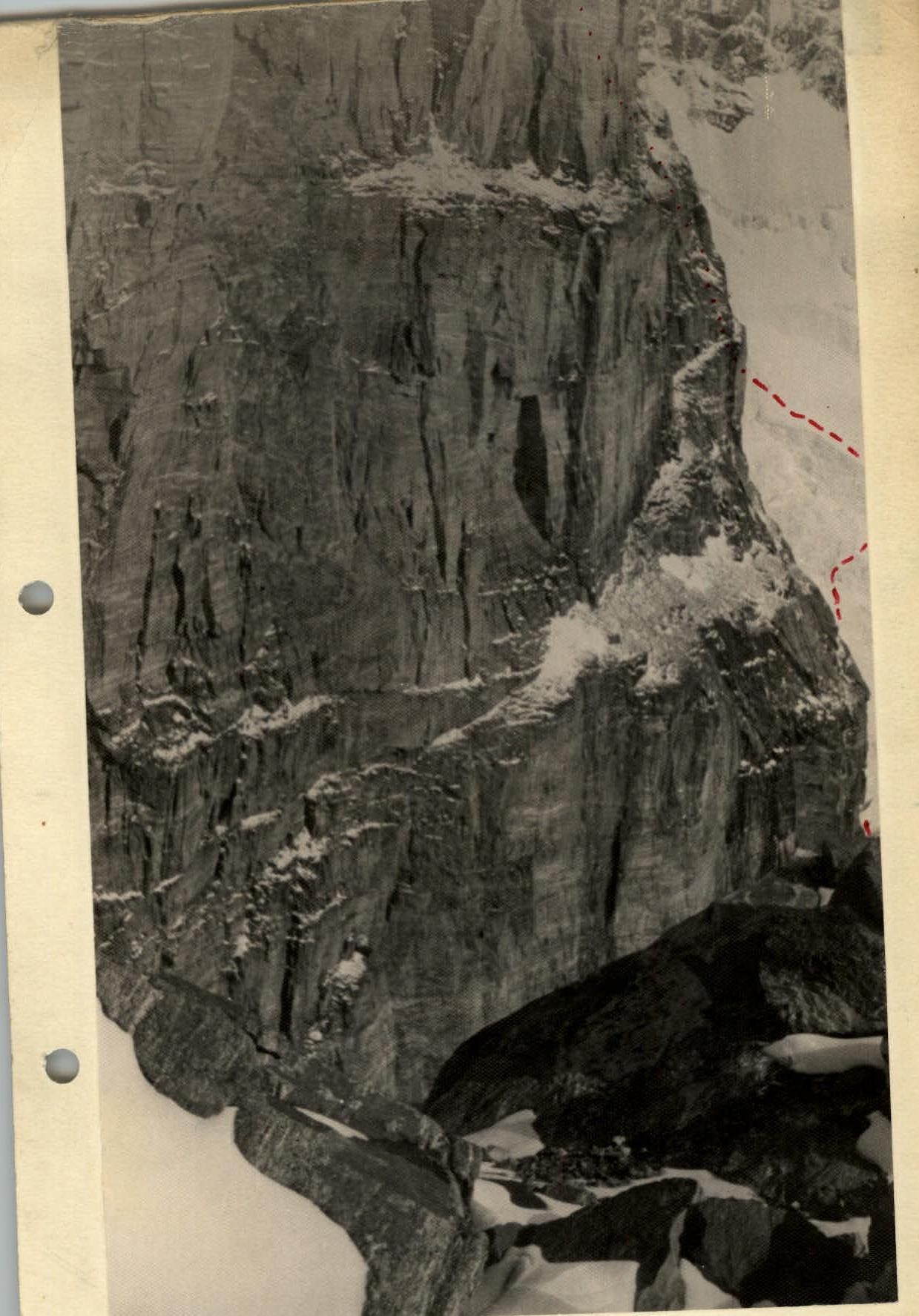
Northern ridge and northern wall of peak Engel'sa.
Passage of the ledge when exiting onto the N. ridge of peak Engel'sa. The blocky structure of rocks is clearly visible (section R13).
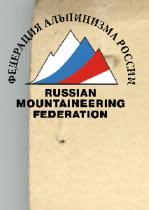
6. Route Log
see route map, photographs, and tables
Route.
August 11, 1964 — at 6:00, the group departs from the assault camp "4800" located under the northern wall of peak Engel'sa. The direction of movement is towards the glacier under the northern wall. To the left and right of the glacier, sheer walls of two buttresses of peak Engel'sa rise. The glacier, squeezed by rocks, is torn by huge crevasses, which can only be overcome near the rocks. In such places, the glacier forms almost sheer walls. Ice fields between the breaks have significant extent and steepness.
Preliminary reconnaissance has established:
- locations for crossing crevasses;
- the safest path.
The first part of the ascent does not present significant difficulties (section R1), thanks to firn covering the ice — crampons hold well. Belaying is done through an ice axe. As the ascent progresses, the firn layer becomes thinner, and on steep sections, it is necessary to drive in ice screws for protection (section R2). Movement is conducted near the left (in the direction of travel) rock face, not illuminated by the sun. Steepness increases, but in the most difficult places, there are preserved steps cut during reconnaissance.
The movement is led by the Kletsko — D'yachenko rope team. The rate of ascent is significant: it is necessary to pass section R3 in the immediate vicinity of the right rock face (in the direction of travel) before it is illuminated by the sun. Overcoming the break is not complicated, as a snow bridge remains. Carefully belaying each other, we exit onto the first ice field (section R4) and immediately move left upwards. Here and further, there is no possibility to move simultaneously; belaying is through pitons. On the ice collection (section R5), we again use old steps. From continuous movement in crampons, legs get cold.
The second ice field (section R6) is located at a significant height. Movement is conducted in the same manner, to the right on the shaded side. Again, there is an ice fall (sections R7 and R8). As the ascent progresses, the difficulty of the fall increases. The distance between driven pitons is reduced to 6–7 m.
A small ledge after the fall leads to another break. There remains an unreliable snow bridge. Boris Kletsko cautiously crosses it near the rocks, belaying is through pitons; however, Kletsko struggles to drive in the next piton: the ice is porous (section R9) — crampons do not hold well. We move extremely cautiously, the pace of movement slows slightly.
After the ice field, we exit onto iced rocks, movement in crampons. Previously, we had hung a perlon rope here (section R10). The rope is fixed with a hook on the wall, under which there is a small ledge; here is the logistics cache. Crampons can be removed.
Further, the first rope team:
- traverses left upwards along a small overhanging wall (section R11);
- exits onto a narrow rock ledge.
The ledge, similar to an overhang (section R12), crosses from right to left upwards a 250-meter granite ledge.
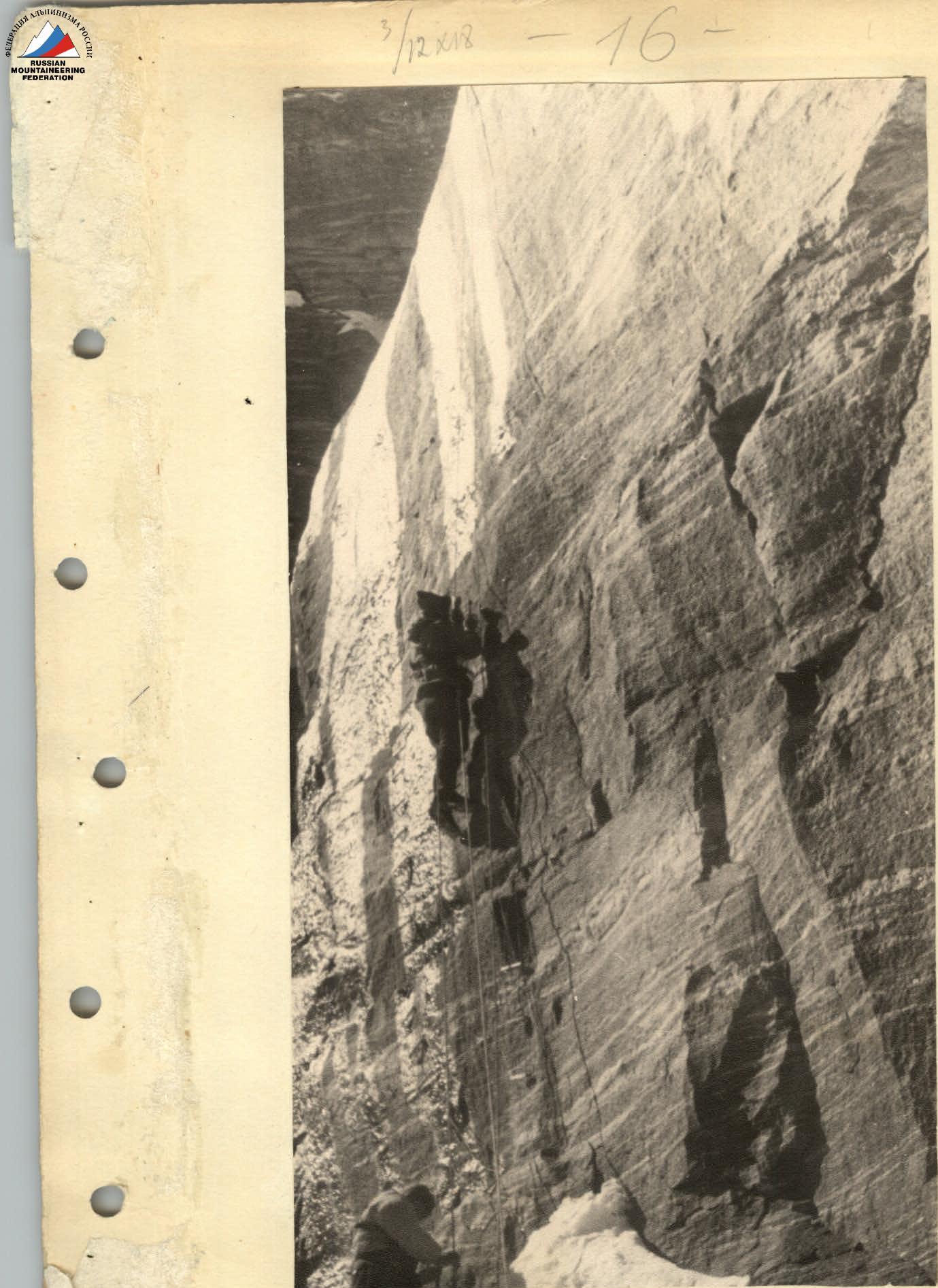 Overcoming the second granite belt on the N. ridge of peak Engel'sa (section R24).
- The rock cornice along the entire length of the ledge reliably protects against rockfall.
The entire path to the ledge took 5 hours. After a short rest, we resume movement. The path is not difficult; however, the ledge is covered with ice, its width does not exceed one and a half meters, and in some places, it narrows to half a meter.
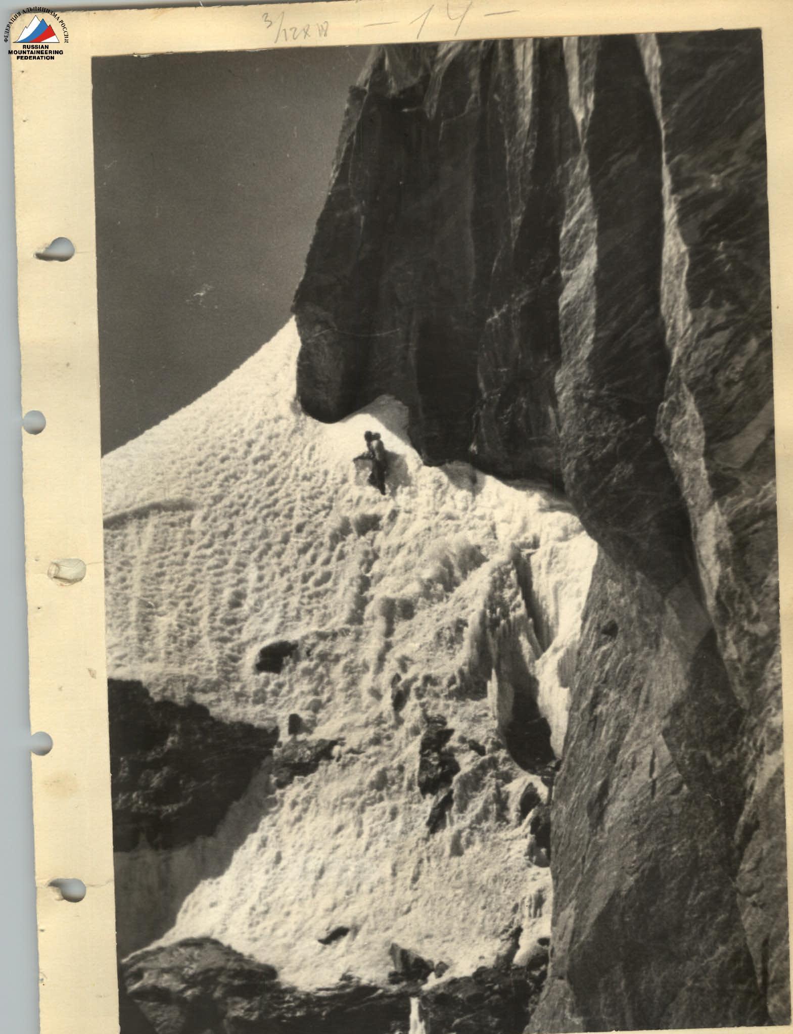
Using previously driven pitons, we quickly move to the upper part of the ledge. At this point, the ledge is intersected by an ice cone, the nearest edge of which forms an almost vertical angle with the rock wall (section R13).
Slowly, with careful belaying, Kletsko overcomes this section. To facilitate the passage, he moves without a backpack. Water drips from above, and icicles fall. To avoid being hit, we move close to the wall.
We exit onto the top of the rock ledge (section R15) and move along its edge left upwards. And after two rope lengths, we turn right and move vertically upwards towards the ridge.
On the ridge, there is an ideal place for a bivouac. At 19:00, the group sets up tents.
August 12, 1964 — we depart from the bivouac at 10:00. It is clear; the sun already illuminates the ridge; the wind is moderate.
Upwards, a not very steep ridge extends (section R16); however, it soon abuts against an inclined slab (section R17) of significant steepness. Further, there is again a simple ridge (section R18), and again, a system of slabs forms a wall (section R19).
Immediately after the wall, a huge monolithic "finger" rises. Passage to the left and movement straight ahead are impossible. A difficult traverse to the right is necessary to bypass the "finger" (section R20).
The traverse leads under an iced wall with an overhanging lower part (section R21). Now, the path is only upwards. The Buda-nov — Kletsko rope team leads the movement. Overcoming the wall, they hang 5 three-step ladders; for the passage of subsequent rope teams, a 25-meter ladder is hung.
The ice field behind the wall (section R22) leads to a short overhanging wall (section R23). An easy section of rocks behind the wall leads to the saddle between the "finger" and the second granite belt.
We spend the rest of the day studying the smooth monoliths hanging over the saddle with a 100-meter wall. Here, we bivouac.
August 13, 1964 — a thorough inspection of the wall convinces us that the most rational path is 2–3 meters to the left of the ridge, where the wall's extent is less. The rock texture is unfavorable: an absolute monolith. With great difficulty, we manage to find a small vertical crack. The Kletsko — D'yachenko rope team goes to process the initial section. Slow movement upwards begins. Only "petal" pitons are used in the granite, but soon the crack ends. To the left, another crack is visible. A difficult ascent follows. Shallow drilling is necessary; otherwise, belaying cannot be ensured. We use two-rope prussiking. But soon, the sound of "petal" pitons is heard again; there is another crack. 35 meters of difficult ascent are traversed (section R24).
Directly above our heads, a chimney formed by a granite monolith and a huge, slightly deviated "cube" rises. The chimney (section R25) does not contain any cracks, and again, shallow drilling is necessary.
After passing the chimney and hanging the rope, the rope team descends to the bivouac.
August 14, 1964 — departing from the bivouac at 10:00, the group quickly traverses the processed section of the path. Backpacks are pulled up on a rope; further, there is a rock "feather" (section R26) requiring painstaking piton work. Buda-nov is the first to ascend. Here, a ladder is hung; again, backpacks are pulled up on a rope — this is one of the most difficult places.
After the "feather," the rock structure changes sharply; instead of granite, metamorphic rocks appear. Rocks are brittle, steep; in some places, it is necessary to overcome short walls. Movement is conducted to the right, parallel to the ridge (section R27). At 19:00, we establish a bivouac. There are no convenient places for two tents. We settle on a 30° slab and, tied in, spend the night.
August 15, 1964 — departure at 10:00; the morning is clear. Again, the path is blocked by a pinnacle. We make a detour along ledges to the right. Brittle rocks require special care in handling the rope and precision in movements (section R28). The ledge leads to short iced rocks (section R29), followed by an ice field (section R30); we put on crampons again. After short iced rocks, there is another ice field (section R31).
It is not possible to exit onto the ridge immediately from the ice; exceptionally brittle rocks do not allow for upward movement; it is necessary to:
- move right (section R32);
- overcome a short wall (section R33);
- traverse right again (section R34).
Only after this can we exit onto the ridge (section R35). Despite the early hour, we establish a bivouac. Reconnaissance of the path is necessary. Again, we have a 50-meter overhanging wall above us. The Ustinov — Kletsko rope team heads upwards. The reconnaissance results are disappointing: there is no path along the ridge. Steep rock drops and snow cornices block the path. Towards evening, signs of deteriorating weather appear. At night, there is a heavy snowstorm.
August 16, 1964 — departure at 10:00. Low cloud cover and strong northwest wind. We bypass the overhangs to the right; the general direction of movement is upwards along the northern wall. We find a barely expressed ledge (section R36); we move along it. Despite minimal ascent, traversing is necessary along an almost sheer slope. Rocks are iced. The traverse is closed by a rock wall (section R37). Serac ice and the sheer wall make the wall practically impassable. Here, a 25-meter ladder is hung. Further, there is a steep ice slope (section R38). Belaying is through pitons. We cut steps. The pace of movement is slow. It is cold; sleet falls. Behind the ice slope, there is a complex rock profile with overhanging sections. There are practically no holds or grips (section R39); the pace is very slow. Rocks are iced; feet often slip. It gets dark, but there is no place for a bivouac. After overcoming the overhanging sections, there is again a wall, and further, a huge rock cornice. There is no hope of finding a convenient bivouac spot. We move left under overhanging rocks and establish a sitting bivouac on tiny ledges. Despite the cold night, the bivouac proceeds normally, facilitated by:
- high-quality down jackets;
- foam pads;
- four-person down sleeping bags.
August 17, 1964 — early in the morning at 8:00, we leave the bivouac site. The weather has improved; the sun brightly illuminates peak Marx. On the northern wall of peak Engel'sa, it will not appear before 13:00. We move vertically upwards along the northern wall (section R40). Rocks become increasingly complex and turn into blocks. There are no holds or footholds. The Buda-nov — Kletsko rope team continuously drives in pitons and hangs ladders. The pace of movement is slow. As we ascend, the edges of a barely expressed couloir converge, forming an overhanging angle. Along one side of this angle, Buda-nov slowly ascends step by step. Rocks are of the highest category of difficulty. Finally, on the junction of the walls, a crack appears, further turning into a crevice, and after another 30 meters, following a short overhanging section, the wall transitions into a 50° slope. Here, the character of the rocks changes again: it is a system of ledges and small walls formed by cubic blocks (section R41). We rest on the ledges and continue upwards. Along loose snow, we exit onto the ice ridge (section R42). For 2 hours, we cut out a platform for tents. After the usual exchange of flares with the observation group, we immediately climb into the tents: it's freezing outside.
August 18, 1964 — clear, frost, strong wind. Departure is late, at 12:00. Since the further part of the path requires crampons, to avoid frostbite on our feet, we depart during the warmest part of the day. We move along the ridge, which is significantly simpler than the route of the previous days. However, it requires careful belaying. On the ridge (section R43), belaying is through an ice axe. We overcome rock and ice sections alternating with each other (sections R44–R47). At 15:00, we reach the summit of peak Engel'sa.
Further, we traverse the summit array in the direction of peak Marx (section R48) and descend along firn (section R49) to rocks (section R50). Here, a rappel descent leads to a simple ridge (sections R51–R52), followed by:
- a descent along an ice slope (section R53);
- a descent along rocks (section R54).
Further along the ice ridge (sections R55–R57) in the direction of the saddle. Bypassing pinnacles on the ridges to the left (in the direction of travel) along numerous ledges, we exit (section R58) to the bivouac site of the first ascenders. We establish a bivouac.
August 19, 1964 — departing at 9:00, after traversing two 40-meter rappel descents (sections R59–R60), along a simple ridge (section R61) and a firn slope (section R62), we exit onto the saddle between peaks Marx and Engel'sa, where we meet the auxiliary group.
August 20, 1964 — rest day. Along with the auxiliary group, the ailing V. Ovsyannikov descends into the Kish-Dzharob valley. The entire day is spent observing the wall of peak Marx. At 16:00, the Ustinov — Konoplev rope team exits onto the slope of peak Marx for reconnaissance and path clearing. At 20:00, the group returns; the path is reconned.
August 21, 1964 — departure from the bivouac at 9:00. A strong northwest wind quickly drives high clouds. The group easily ascends along the cleared path (sections R63–R64). From the north, the valley is shrouded in fog; visibility decreases. We quickly find the safest place on the plateau under peak Nikoladze, establish a bivouac. The weather has not improved by evening.
August 22, 1964 — departure at 9:00. The sun shines brightly. The general direction is to the right, bypassing ice falls, towards the ice gully. The rate of ascent is high. The path is not complicated (section R65). The ascent along the ice gully is difficult; the ice is smooth, polished. We move on the front points of our crampons (section R66). The ice gully is the most dangerous part of the ascent to peak Marx.
Further:
- we immediately move right along steep ice (section R67);
- traverse the ice fall (section R68) to the right;
- exit onto a barely expressed snow ridge.
Movement along the ridge is monotonous and tiring (section R69): the snow is poorly firned; it is necessary to repeatedly compact footholds; we frequently change the lead. Movement along the ridge is safe. At 17:00, the sun hides behind peak Marx; it becomes cold. We choose a convenient and safe place for a bivouac. There is no visual contact with the camp here; therefore, we send a high-altitude signal flare to indicate the group's well-being.
August 23, 1964 — the first rays of the sun warm the tent; we depart at 9:00. Movement along the ridge is impossible due to numerous crevasses. We move left upwards. The ice is steep; the snow has poor adhesion to the slope. We carefully belay each other and approach the ice fall (sections R70–R71) and move left along it.
It takes a long time to cut out a hollow before we can drive in a piton: the ice is porous. Further, we move vertically upwards along steep ice and approach an ice barrier. It is not possible to overcome the barrier; we bypass it upwards and to the right. Finding a lowering in the barrier (section R73), we overcome it on the front points of our crampons and along short firn ascents (section R74), we exit onto a wide pre-summit ridge (section R75).
We move simultaneously. We reach the summit at 16:00 and begin our descent along the route of the first ascenders. We traverse a relatively steep ice ridge (section R76) and descend along a long shale scree (section R77) to the upper reaches of the Nishgar Glacier. We spend the night on the glacier.
August 24, 1964 — departure at 10:00 in the morning. After a small ascent (section R78), a descent along the ice fall (section R79) leads us to the Nezhdan pass. The descent from the pass onto the Marx Glacier along rock slabs and ledges (section R80) leads to the moraine of the Marx Glacier. We return to the base camp along the glacier.
August 25, 1964 — together with the observation group, we evacuate the camp to the village "Djaushan-gos," from where we travel by car to Dushanbe.
The group considers the traversed traverse one of the most interesting in this area, characterized by overcoming the most complex ice and rock sections at a significant altitude (6300–6700 m). Considering the length and complexity of the traverse, the group proposes categorizing the traverse of peaks Engel'sa and Marx from east to west as the highest category 6B.
b) Evaluation of the Actions of the Assault Group Participants.
All participants of the assault group demonstrated themselves to be highly qualified and physically well-prepared alpine climbers. This allowed for frequent rotation of the leading rope team without losing the pace of movement.
Contribution of the assault group participants:
- All participants made a significant contribution to the passage of this interesting and complex route.
c) Auxiliary Group. The group consisted of 3 people:
- S.I. Sekretarev — group leader, 1st sports category.
- L.S. Agranovskaya — Master of Sports.
- Yu.I. Kendzerskii — doctor, 1st sports category.
The group conducted daily observations of the assault group.
Twice a day, two-way radio communication was maintained with the expedition leader of the Central Council of the "Spartak" Sports Society, V. Abalakov.
Communication with the assault group was carried out using flares. The observation group successfully fulfilled its task. During the preparation for the ascent, all participants of the auxiliary group made an ascent of peak K. Marx, category 5A.
Team Captain: /BUDANOV/
| Date | Section traversed | Average steepness | Length in meters | Characteristics of the section and conditions of passage | Technical difficulty | Belaying method | Weather conditions | Time of departure | Stops | Working hours | Number of rock pitons driven | Number of ice pitons driven | Number of drilled pitons | Bivouac conditions | Weight of daily ration |
|---|---|---|---|---|---|---|---|---|---|---|---|---|---|---|---|
| 11.08.1964 | R1 | 40 | 200 | Ice fall | 3Б | alternating | clear | 6:00 | good | 0.8 | |||||
| — " — | R2 | 50 | 300 | Ice slope | 4Б | piton | 3 | ||||||||
| — " — | R3 | 30 | 120 | Traverse of ice crevasse | 4А | piton | 2 | ||||||||
| — " — | R4 | 50 | 100 | Ice field | 4А | piton | 4 | ||||||||
| — " — | R5 | 60 | 50 | Ice wall | 5Б | piton | 3 | ||||||||
| — " — | R6 | 50 | 100 | Ice field | 4Б | piton | 2 | ||||||||
| — " — | R7 | 70 | 20 | Ice wall | 5Б | piton | 3 | ||||||||
| — " — | R8 | 70 | 20 | Ice fall | 5Б | piton | 4 | ||||||||
| — " — | R9 | 60 | 100 | Ice field | 5Б | piton | 5 | ||||||||
| — " — | R10 | 70 | 60 | Iced rocks | 5Б | piton | 1 | ||||||||
| — " — | R11 | 90 | 3 | Rock overhang | 5Б | piton | 8 | ||||||||
| — " — | R12 | 30 | 100 | Rock ledge | 5А | piton | 5 | ||||||||
| — " — | R13 | 80 | 15 | Serac ice | 5Б | piton | 2 | ||||||||
| — " — | R14 | 30 | 80 | Disintegrated rock ledge | 4А | piton | 1 | ||||||||
| — " — | R15 | 60 | 80 | Disintegrated rocks | 4А | piton | 13 | ||||||||
| 12.08.1964 | R16 | 20 | 70 | Rock ridge | 3Б | alternating | good weather | 19:00 | 2 | good | 0.6 | ||||
| — " — | R17 | 70 | 30 | Slab | 4Б | piton | 1 | ||||||||
| — " — | R18 | 10 | 40 | Rock ridge | 3А | alternating | 4 | ||||||||
| — " — | R19 | 80 | 50 | Rock wall | 5А | piton | 3 | ||||||||
| — " — | R20 | 10 | 50 | Traverse under wall | 4Б | piton | 1 | ||||||||
| — " — | R21 | 90 | 30 | Overhanging wall | 5Б | piton | 8 | ||||||||
| — " — | R22 | 60 | 20 | Ice slope | 5Б | piton | 1 | ||||||||
| — " — | R23 | 90 | 5 | Overhanging wall | 5Б | piton | 19:00 | 8 | |||||||
| 13.08.1964 |