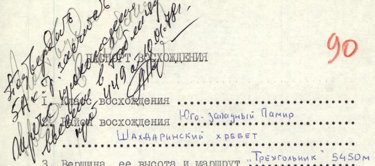
Climbing Information
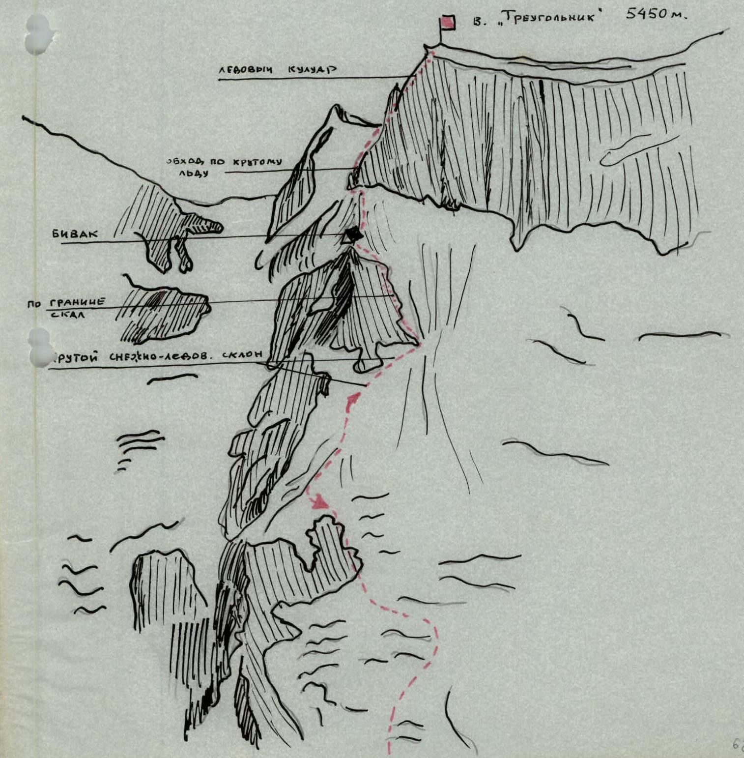
- Ascent: South-West Pamir
- Mountain range: Shakhdarin Range
- Peak, its height, and route: «Treугольник» (Triangle) 5450 m
- Estimated difficulty category: 5A (via the north-west ridge)
- Route characteristics:
- Height difference: 650 m
- Average steepness: 50°
- Section lengths:
- R1: 300 m
- R2: 220 m
- R3: 120 m
- R4: 80 m
- R5: 120 m
- R6: 50 m
- R7: 80 m
- R8: 80 m
- R9: 40 m
- Pitons used:
- For belaying: 34 rock, 11 ice
- For anchors, etc.: —
- Climbing hours: 21
- Number of bivouacs and their characteristics: one bivouac on a snowy shoulder
- Leader and team members' names, their sports qualification:
- Tinin Yuri Pavlovich — 1st sports category
- Zybin Alexander Nikolaevich — 2nd sports category
- Shibanov Alexander Viktorovich — 2nd sports category
- Team coach: Kavunenko V.D.
- Date of departure and return:
Report on the ascent of «Treугольник» (Triangle) via the north-west ridge, 5A category, team of MGS DSO «Spartak» (led by Tinin Yu.P.)
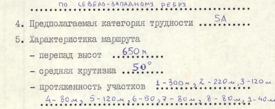
Third ascent
Route description
From the moraine bivouac, descend to the glacier tongue below, which flows from the northern slopes of «Treугольник» (Triangle) peak. Ascend the glacier tongue in its middle part and reach a steep icefall, which is also climbed in its middle section, leaving the first rock massif on the left. At the end of the icefall, traverse left-up via snow and steep ice (belays) onto simple, destroyed rocks in the upper part of the first rock massif to reach the 1st snowy "knife".
Then ascend the "knife" towards the second rock massif. This section is 4 rope lengths, average steepness 40–45°, with possible ice exposures (belays). Traverse a steep snow-ice slope (pitons for belays) to the right, bypassing the rock massif (3 rope lengths). In the lower right part of the rock massif, there's a convenient spot for belaying via rock pitons and outcrops.
The second rock massif is bypassed on the right via a wide snow-ice couloir on the left side, along the boundary between snow and rocks. Section length is 4 rope lengths, piton belays, rocks are destroyed (!). Then ascend onto the snowy ridge via a steep snow slope (2 rope lengths). Reach the second snowy "knife". Bivouac. From the moraine bivouac to this point — 8–9 hours. It's advisable to complete this section in the early hours.
From the bivouac, ascend the second snowy "knife" towards «Treугольник» (2–2.5 rope lengths, 30 minutes). Traverse «Treугольник» on the left along the ice-rock boundary (steep ice, piton belays, three rope lengths). Then ascend destroyed rocks of medium difficulty (belays via outcrops, pitons, 70 m). Reach a couloir with ice and snow. Ascend the couloir to the ridge — 2 rope lengths (belays, rock and ice pitons). From the ridge to the summit — simultaneous movement. From bivouac to summit — 5 hours. Descent via the ascent route — 7 hours.
Team composition
- Tinin Yu.P. — leader, 1st sports category
- Zybin A.N. — team member, 2nd sports category
- Shibanov A.V. — team member, 2nd sports category
Team equipment
- Main rope: 2×40 m
- Rock pitons: 15 pieces
- Ice pitons (ice screws): 4 pieces
- Crampons: 3 pairs
- Disposable cordelette: 10 m
Notes
- All snow-ice sections were climbed with crampons.
- The section "second snowy 'knife' – summit ridge" is impassable in the second half of the day due to high rockfall danger.
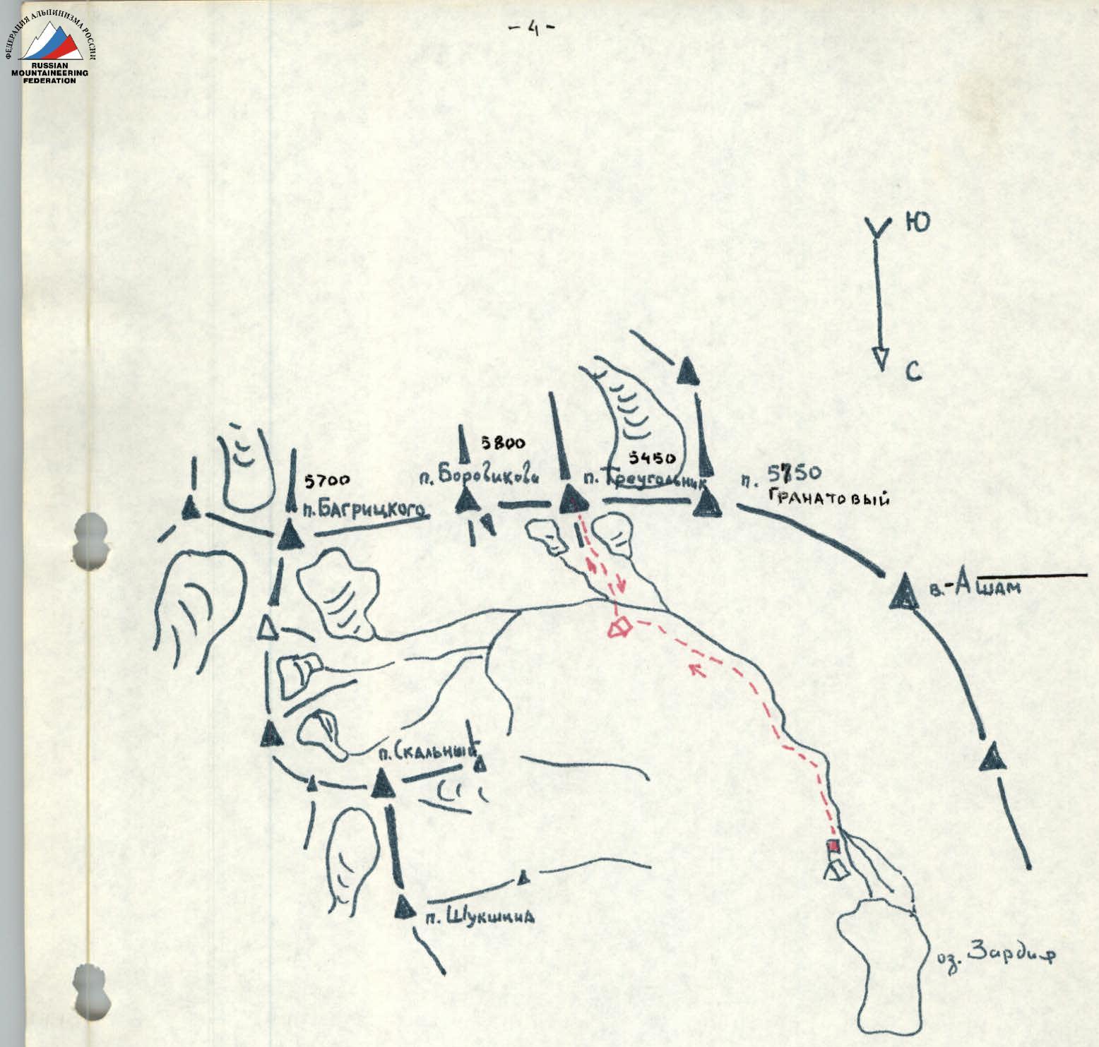
Climbing route map
| Date | Designations | Average steepness of section | Length, m | Terrain characteristics | Difficulty category | Conditions | Weather conditions | Rock pitons | Ice pitons | Bolt |
|---|---|---|---|---|---|---|---|---|---|---|
| R0–R1 | 35° | 300 | Icefall | 2 | Broken, slight snow cover | Good | 2 | |||
| R1–R2 (2nd snowy knife and steep snow-ice ascent) | 45° | 220 | Snowy ridge, snow-ice slope | 2–4 | Wet snow, clean ice | Good | 3 | 5 | ||
| R2–R3 | 55° | 190 | Ice couloir, movement along rock boundary | 4–5 | Wet ice, rocks wet, destroyed | Good | 12 | |||
| Bivouac | R3–R4 | 50° | 80 | Snowy couloir | 3 | Snow cover 0.5 m thick | Good | |||
| R4–R5 (2nd snowy knife) | 40° | 120 | Snowy ridge | 3 | Hard snow | Good | ||||
| R5–R6 | 50° | 50 | Snow-ice slope | 4–5 | Ice | Good | 4 | |||
| R6–R7 | 75° | 80 | Rock walls | 4–5 | Destroyed rocks, ice-covered, rockfall | Good | 14 | |||
| R7–R8 | 55° | 80 | Ice couloir, rock "islands" | 4 | Ice, rockfall | Good | 5 | |||
| R8–R9 | 35° | 40 | Snowy ridge | 2 | Good |