Ascent Passport
I. Ascent category — high-altitude technical 2. Ascent area — South-Western Pamir 3. Ascent route — TajGU Peak via the ESE wall, 6B category of difficulty (V. Solonikov's route) 4. Route characteristics: height difference — 1080 m average steepness — 80° length of 6B category of difficulty — 455 m 5B — 510 m 5. Pitons driven: rock — 164 chocks — 80 ice — none bolt — none 6. Time spent on the route — 36 hours 7. Number of bivouacs on the route — 4 8. Team of the Committee for Physical Culture and Sports under the Irkutsk Regional Executive Committee 9. Team members: Popov Valery Nikolayevich — Master of Sports of the USSR — team captain and coach Zhila Andrey Yuvinialyevich — Master of Sports of the USSR — team member Egranov Viktor Vasilyevich — Candidate Master of Sports Savin Vladimir Viktorovich — Candidate Master of Sports Finkelstein Boris Lvovich — Candidate Master of Sports 10. Date of departure for the route — August 20, 1983, at 16:07 and return — August 24, 1983.

Tajik State University Peak
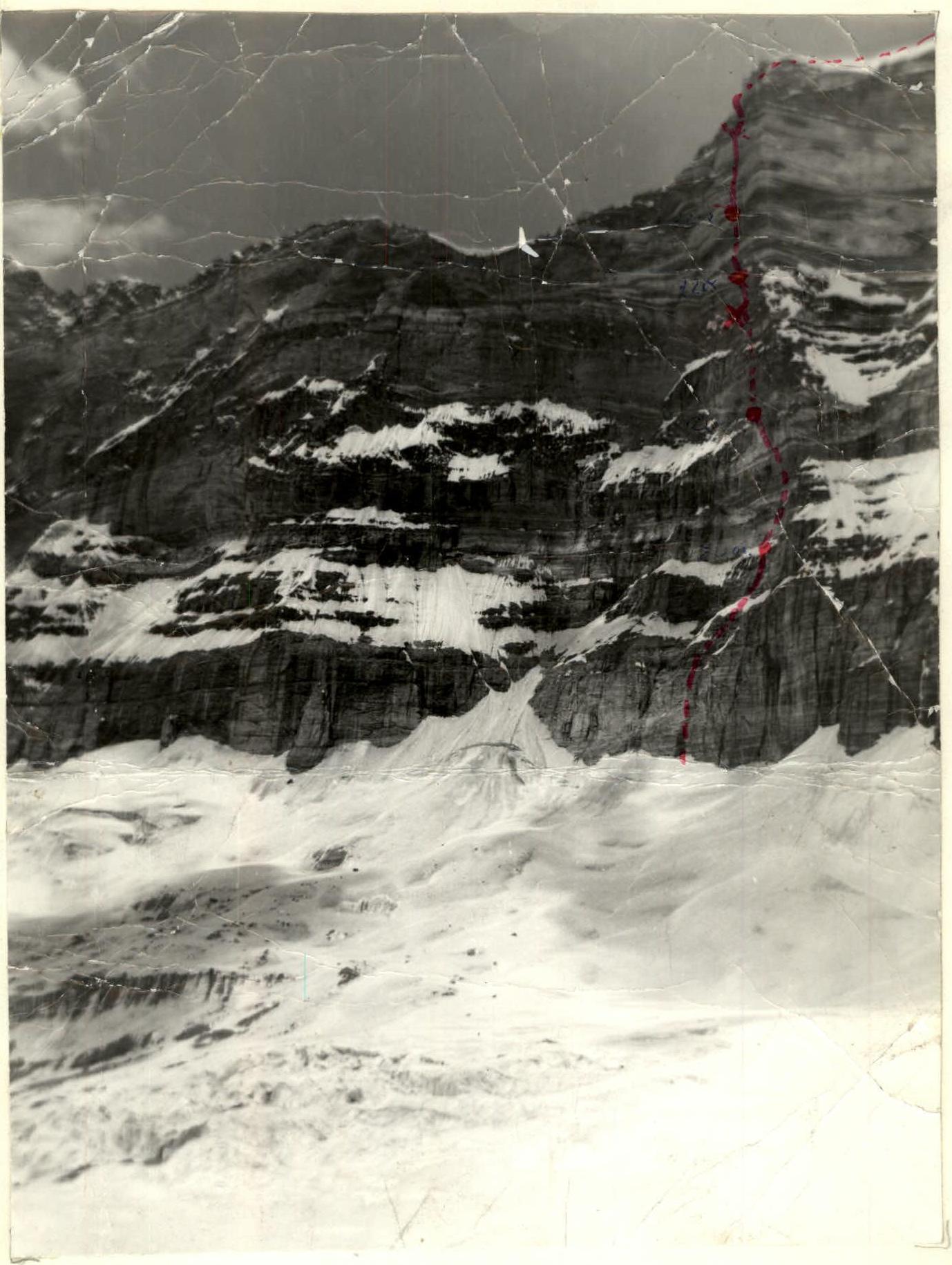
Judge's signature on the back of the photograph.
Pre-Ascent Preparation
I. Choice of Ascent Object
For the RSFSR Championship in the high-altitude technical category, we had submitted two objects in the South-Western Pamir (both 6B category of difficulty): Moscow Pravda Peak and TajGU Peak via V. Solonikov's routes, which had been marked with gold medals in the USSR Championships. There is another route on TajGU Peak by a Georgian team (led by V. Kartvelashvili), also 6B category of difficulty. However, the key section of this route is a 250-meter wall requiring exclusively "industrial" climbing, which, in our opinion, reduces its sporting value.
Upon arrival, we learned that the route on Moscow Pravda Peak had already been climbed this season five times (twice for the RSFSR Championship and three times for the Championship of the Soviet Army and Navy). Virtually all technical and tactical problems of this route had already been solved. Therefore, we chose the route on TajGU Peak via the ESE wall.
II. Tactical Ascent Plan.
This route demands high requirements for the technical and psychological preparation of participants. The decisive factor for a successful ascent is the style of climbing the wall, the team's technical equipment, and the physical and technical preparedness of the participants, resulting in a high pace of ascent.
We planned to complete the route in 40–50 hours (3–4 bivouacs on the route). However, upon examining the wall, the rockfall hazard in its lower part (R1–R4) became apparent until 15–16 hours. Therefore, a plan was adopted to start the route at 16:00 on the first day with four bivouacs.
In our view, the value of climbing a difficult wall decreases with prior processing, so this stage was excluded from the tactical ascent plan.
The following scheme of group movement on the route was adopted: the first climber ascends without a backpack with double-rope belay. Each subsequent participant also works with a double rope (one rope serves as a "peril", the other as upper belay). This scheme ensures not only a high pace of movement but also sufficient reliability and has been used by the team on all complex routes for several years.
Studying the 300-meter bastion (sections R2–R17) showed that throughout this section, the group would not have access to water, so it was planned to bring 7–8 kg of ice in special packaging from the third bivouac in case of a bivouac on the bastion.
Training Cycle
During the winter period, team members completed a large volume of general physical training (skiing, cross-country running). Alongside this, special training on rocks began in February despite the severe frosts.
The first ascents of the season were made in May at an alpinist gathering in Eastern Sayan. Then, all team members worked as instructors or trainees at the Varzob alpine camp. During this time, several complex ascents were made to the peaks of Zamin Karor and Mechta. In particular, S. Efimov's route on Zamin Karor Peak, 6B category of difficulty, was climbed. The next stage of preparation was a training camp held in the South-Western Pamir, after which the final team composition was confirmed.
Tactical Actions of the Team
On August 20, 1983, at 16:07, the team approached the internal corner serving as the starting point of the route. After 80 m of complex climbing, the path leads to a chimney, in the middle of which a bolt piton with a torn ear is driven. Further along an inclined slab, we reach a narrow shelf. We decide to set up a bivouac here since there are cracks for organizing belays (although the planned bivouac spot is still 40 m up the wall). While three team members set up a suspended platform, the Egranov-Zhila pair processes the remaining 40 m to the planned bivouac.
August 21, 1983. The Egranov-Finkelstein pair leads ahead. The terrain remains the same: internal corners, slabs. The entire range of rock pitons is in use. Chock stones, especially the "hex" set with chosen faces combining the principles of "hex" and "eccentric," are also widely used. At 19:00, the group reaches the planned bivouac. There is a wide shelf with a platform for a tent where a control cairn is found.
August 22, 1983. Movement begins through a long internal corner with inconvenient leader changes. The Popov-Zhila pair leads. Internal corners alternating with steep rock walls are climbed using free climbing without artificial aids. The bivouac spot is inconvenient, so a platform with a tent for four participants is hung. The fifth person spends the night in a hammock.
August 23, 1983. Before us lies the key section of the route — a virtually sheer, partially overhanging rock wall. The Popov-Zhila pair leads. Difficult climbing, partially using ladders, covers the first 40 m. The next 80 m (wall and internal corner with overhangs) are only passed using artificial aids. Specially made petal pitons with welded ears are used. In areas where cracks are completely absent, "sky hooks" are used, which have saved us more than once, including on Yaghnob.
A steep black slab (section R14–R15) is climbed using free climbing; the few pitons that can be driven are used only for belays. A very complex internal corner is also climbed using free climbing, and then a traverse to the left along a rock wall leads us to the last bivouac. At 18:45, the first pair reaches the control cairn.
August 24, 1983. The Savin-Finkelstein pair leads. After two and a half ropes of complex climbing to bypass an overhang, the group reaches the ridge. The wall is climbed. In another hour, we reach the summit.
Table
Main data of the ascent route to TajGU Peak via the ESE wall. Height difference of the route is 1080 m. Steepness of the route is 80°.
| Date | Section | Steepness | Vertical Length in m | Terrain Characteristics | Category of Difficulty | Condition | Weather Conditions | Rock Pitons | Chock Pitons | Bolt Pitons | Notes |
|---|---|---|---|---|---|---|---|---|---|---|---|
| I | 2 | 3 | 4 | 5 | 6 | 7 | 8 | 9 | 10 | 11 | 12 |
| 20.08.83 | R0–R1 | 85 | 80 | Internal corner | U.B | monolith | good | 10 | 8 | - | Departure at 16:07. Bivouac on a suspended platform and hammock at 20:00. 4 hours climbing. |
| R1–R2 | 90 | 20 | Chimney | U.I | monolith | "—" | 7 | 3 | - | ||
| R2–R3 | 60 | 20 | Inclined slab | IУ | loose rocks | "—" | 7 | - | 3 | ||
| 21.08.83 | R3–R4 | 60 | 80 | Rock wall with good holds | U.B | loose rocks | overcast | 10 | 7 | - | Snow at night. Departure at 9:00. Bivouac at 19:00. 10 hours climbing. Control cairn. |
| R4–R5 | 70 | 15 | Traverse with ascent up steep wall | IУ | loose rocks | "—" | 3 | - | - | ||
| R5–R6 | 90 | 40 | Internal corner | U.I | monolith | "—" | 8 | 8 | - | ||
| R6–R7 | 80 | 40 | Steep slab-like rocks | U.B | many "live" rocks | "—" | 5 | - | - | ||
| 21.08.83 | R7–R8 | 85 | 40 | Internal corner | U.I | monolith | "—" | 7 | 6 | - | |
| R8–R9 | 80 | 40 | Rock wall with few holds | U.B | monolith | "—" | 6 | 1 | - | ||
| 22.08.83 | R9–R10 | 90 | 80 | Internal corner | U.I | monolith | clear | 15 | 5 | - | Departure at 9:00. Stop at 19:00. 10 hours climbing. Bivouac on platform and hammock. |
| R10–R11 | 85 | 270 | Alternating rock walls and internal corners | U.B | monolith | "—" | 20 | 18 | - | ||
| 23.08.83 | R11–R12 | 85 | 40 | Internal corner | U.I | monolith | clear | 7 | 5 | - | Departure at 9:00. Stop at 18:45. 10 hours climbing. Bivouac on platform and hammock. 8 kg ice. Control cairn. |
| R12–R13 | 90 | 20 | Rock wall | U.I | monolith | "—" | 4 | 2 | - | ||
| R13–R14 | 90 | 60 | Internal | U.I | monolith | "—" | 25 | 11 | 10 | driven by previous climbers | |
| R14–R15 | 90 | 40 | Steep rock slab | U.I | monolith | "—" | 8 | 3 | - | Control cairn. | |
| R15–R16 | 85 | 50 | Internal corner | U.I | monolith | "—" | 9 | - | - | ||
| R16–R17 | 80 | 40 | Traverse along rock wall | U.B | monolith | "—" | 7 | - | - | ||
| 24.08.83 | R17–R18 | 80 | 40 | Rock wall | U.B | monolith | clear | 8 | 2 | - | Departure at 9:00. |
| R18–R19 | 90 | 40 | Internal corner | U.I | monolith | "—" | 7 | 5 | - | At 11:00, the group reached the ridge. | |
| R19–R20 | 90 | 25 | Rock wall | U.I | monolith | "—" | 2 | 5 | - | ||
| R20–R21 | 20 | 250 | Snow slope | I | loose snow | "—" | - | - | - | At 12:00 — summit. Descent to Rovny Glacier. |
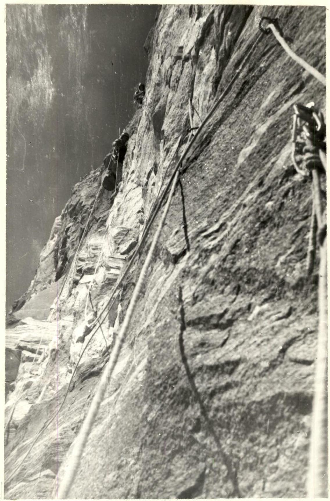 Section R12–R13
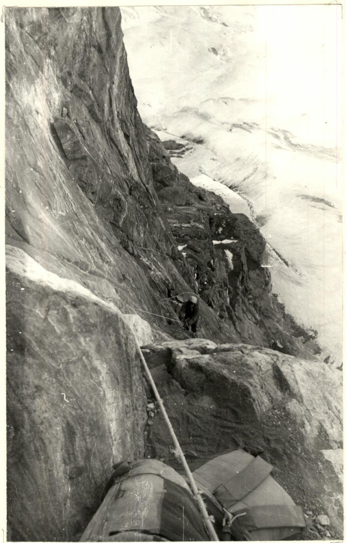 Section R14–R15