
Ascent Passport
- Ascent class — high-altitude and technical
- Ascent area, ridge — South-West Pamir, Shakhdara Ridge
- Peak, its height, ascent route — TajGU peak, 6183 m, via the center of the Eastern wall
- Assumed category of difficulty — 5B
- Route characteristics: height difference — 1240 m, length of sections with 5–6 category of difficulty — 1030 m, average steepness — 80°
- Pitons hammered:
| for belay | for creating I.T.O. | |
|---|---|---|
| rock | 213 | 15 |
| ice | 7 | – |
| bolt | 7 | 6 |
| chocks | 29 | – |
- Number of travel hours — 52 h
- Number of bivouacs and their characteristics — 4 lying, 1, 2 — on snow, 3, 4 — on rock ledges
- Surname, name, patronymic of the leader, participants and their qualification —
- Golubenko Mikhail Nikolaevich, CMS, leader
- Boyko Vasily Grigorievich, CMS, participant
- Bovkun Vladimir Romanovich, CMS
- Gurov Vladimir Nikolaevich, CMS
- Zaitsev Vladimir Elizvoevich, CMS
- Sentsov Sergey Konstantinovich, CMS
- Team coach — Kensitsky Leopold Vsevolodovich
- Date of departure to the route and return — July 10 — July 19, 1979
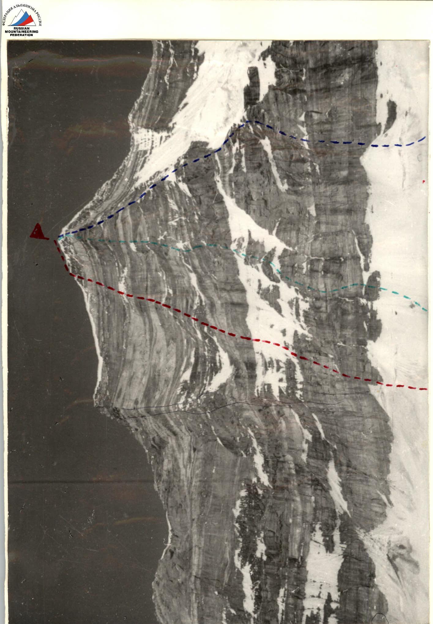
- Popenko's route 1978
- Solonnikov's route 1979
- Krasnoshchekov's route
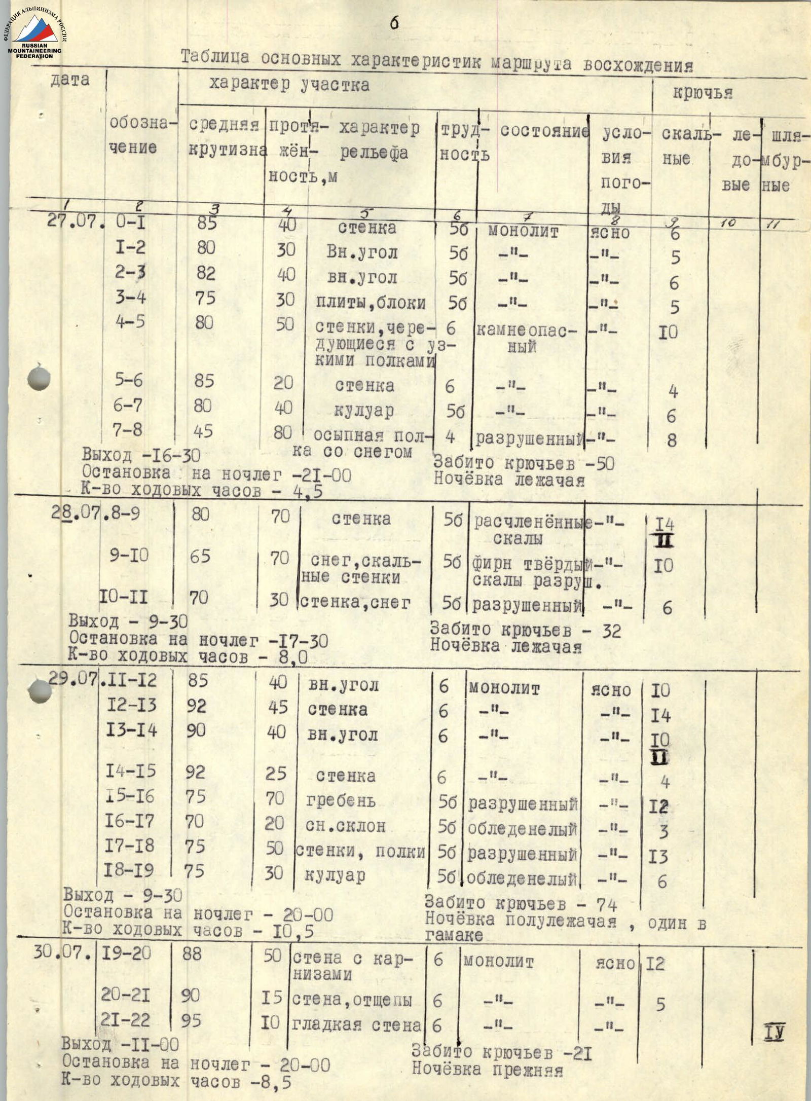
Table of main characteristics of the ascent route
| Date | Designation | Average steepness | Length, m | Character of relief | Difficulty | Condition | Weather conditions | Rock pitons | Ice pitons | Bolt pitons | Chocks |
|---|---|---|---|---|---|---|---|---|---|---|---|
| 27.07 | R0–R1 | 85° | 40 m | wall | 6 | monolith | clear | 6 | |||
| R1–R2 | 80° | 30 m | inner corner | 5 | monolith | – | 5 | ||||
| R2–R3 | 82° | 40 m | inner corner | 6 | monolith | – | 6 | ||||
| R3–R4 | 75° | 30 m | slabs, blocks | 5 | monolith | – | 5 | ||||
| R4–R5 | 80° | 50 m | walls alternating with ledges | 6 | rockfall prone | – | 10 | ||||
| R5–R6 | 85° | 20 m | wall | 6 | – | – | 4 | ||||
| R6–R7 | 80° | 40 m | couloir | 5–6 | monolith | – | 6 | ||||
| R7–R8 | 45° | 80 m | detritus ledge with snow | 4 | destroyed | – | 8 | ||||
| Departure — 16:30. Bivouac stop — 21:00. Number of travel hours — 4.5 h. Pitons hammered — 50. Bivouac lying. | |||||||||||
| 28.07 | R8–R9 | 80° | 70 m | wall | 5–6 | dissected rocks | – | 14 | 1 | ||
| R9–R10 | 65° | 70 m | snow, rock walls | 5–6 | firm snow, destroyed rocks | – | 10 | ||||
| R10–R11 | 70° | 30 m | wall, snow | 5–6 | destroyed | – | 6 | ||||
| Departure — 9:30. Bivouac stop — 17:30. Pitons hammered — 32. Bivouac lying. | |||||||||||
| 29.07 | R11–R12 | 85° | 40 m | inner corner | 6 | monolith | clear | 10 | |||
| R12–R13 | 92° | 45 m | wall | 6 | monolith | – | 14 | ||||
| R13–R14 | 90° | 40 m | inner corner | 6 | monolith | – | 10 | ||||
| R14–R15 | 92° | 25 m | wall | 6 | monolith | – | 4 | ||||
| R15–R16 | 75° | 70 m | ridge | 5–6 | destroyed | – | 12 | ||||
| R16–R17 | 70° | 20 m | snow slope | 5–6 | icy | – | 3 | ||||
| R17–R18 | 75° | 50 m | walls, ledges | 5–6 | destroyed | – | 13 | ||||
| R18–R19 | 75° | 30 m | couloir | 5–6 | icy | – | 6 | ||||
| Departure — 9:30. Bivouac stop — 20:00. Number of travel hours — 10.5 h. Pitons hammered — 74. Bivouac semi-reclining, one in a hammock. | |||||||||||
| 30.07 | R19–R20 | 88° | 50 m | wall with cornices | 6 | monolith | clear | 12 | |||
| R20–R21 | 90° | 15 m | wall, exfoliations | 6 | monolith | – | 5 | ||||
| R21–R22 | 95° | 10 m | smooth wall | 6 | monolith | – | 5 | ||||
| Departure — 11:00. Bivouac stop — 20:00. Number of travel hours — 8.5 h. Pitons hammered — 21. Bivouac same as before. | |||||||||||
| 31.07 | R21–R22 | 95° | 30 m | smooth wall | 6 | monolith | clear | 14 | |||
| Departure — 9:30. Bivouac stop — 20:00. Number of travel hours — 10.5 h. Pitons hammered — 14. Bivouac separate. | |||||||||||
| 01.08 | R21–R22 | 96° | 30 m | smooth wall | 6 | monolith | clear | 11 | |||
| Departure — 9:00. Bivouac stop — 20:00. Number of travel hours — 11.0 h. Pitons hammered — 11. Bivouac same as before. | |||||||||||
| 02.08 | R22–R23 | 92° | 70 m | wall with cornices | 6 | monolith | cloudy, sleet, 15° | 129 | |||
| Departure — 9:30. Bivouac stop — 20:00. Number of travel hours — 10.5 h. Pitons hammered — 129. Bivouac semi-reclining. | |||||||||||
| 03.08 | R23–R24 | 88° | 80 m | inner corners with cornices | 6 | monolith | clear | 20 | |||
| R24–R25 | 83° | 120 m | walls, blocks | 5–6 | slightly destroyed | – | 30 | ||||
| R25–R26 | 20° | 500 m | snow slope | 3 | firm snow | – | |||||
| Departure — 9:30. Summit reached — 21:00. Number of travel hours — 11.5 h. Pitons hammered — 57. Bivouac on Rovny Glacier. | |||||||||||
| Total: | Number of travel hours — 75 h. | ||||||||||
| Rock pitons hammered — 256, bolt pitons — 26. | |||||||||||
| Route length — 1215 m. Including 5 category of difficulty — 630 m, 6 category of difficulty — 505 m. |
The entire route, except for sections R7–R8, R9–R10, R16–R17, requires passing the first in galoshes. The wall is lit by the sun from 7:40 to 14:15. At this time, there is an exceptional rockfall danger on sections R0–R7.

Table of main characteristics of the ascent route

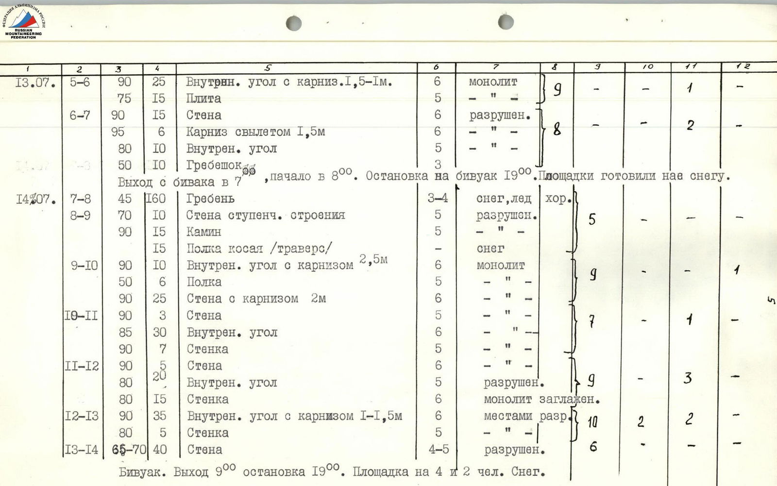
| Date | Designation | Average steepness | Length, m | Character of relief | Difficulty | Condition | Weather conditions | Rock pitons | Ice pitons | Bolt pitons | Chocks |
|---|---|---|---|---|---|---|---|---|---|---|---|
| 12.07 | R0–R1 | 45° | 50 m | slope with bergschrund and randkluft | 3 | calga snow | good | via ice axe | |||
| R1–R2 | 75° | 3 m | wall with exfoliation | 5 | monolith | – | 6 | ||||
| R2–R3 | 90° | 8 m | chimney | 5 | monolith | – | |||||
| R2–R3 | 80° | 20 m | smooth wall | 5 | monolith | – | |||||
| 15 m | wide ledge under an overhanging wall | 2 | without stones | – | |||||||
| R2–R3 | 95° | 10 m | left face of a huge outer corner | 6 | monolith smoothed | – | 14 | 4 | |||
| 90° | 35 m | wall of the outer corner | 6 | monolith smoothed | – | ||||||
| 90° | 40 m | edge of the outer corner | 6 | monolith smoothed | – | ||||||
| Processing started at 10:00, finished at 17:00. Bivouac under the 5200 m pass on the moraine. | |||||||||||
| 13.07 | R3–R4 | 90° | 7 m | wall/traverse | 6 | monolith smoothed | good | 10 | 1 | ||
| 90° | 12 m | inner corner | 6 | monolith smoothed | – | ||||||
| 45° | 20 m | ledge with sheer walls | 3 | "live stones" | – | ||||||
| 10 m | horizontal ledge | 1 | – | – | |||||||
| 75° | 30 m | slabs | 6 | monolith smoothed | – | ||||||
| R4–R5 | 90° | 35 m | inner corner | 6 | monolith | – | 10 | 2 | |||
| 80° | 12 m | slab with cornice | 5 | monolith | – | ||||||
| R5–R6 | 90° | 25 m | inner corner with a 1.5 m cornice | 6 | monolith | – | 9 | 1 | |||
| 75° | 15 m | slab | 5 | monolith | – | ||||||
| R6–R7 | 90° | 15 m | wall | 6 | destroyed | – | |||||
| 95° | 6 m | cornice with a 1.5 m overhang | 6 | destroyed | – | 8 | 2 | ||||
| 80° | 10 m | inner corner | 5 | destroyed | – | ||||||
| R7–R8 | 50° | 10 m | ridge | 3 | – | – | |||||
| Departure from the bivouac at 7:00, start at 8:00. Stop at the bivouac at 19:00. Platforms were prepared on snow. | |||||||||||
| 14.07 | R7–R8 | 45° | 160 m | ridge | 3–4 | snow, ice | good | ||||
| R8–R9 | 70° | 10 m | wall of stepped structure | 5 | destroyed | – | 5 | ||||
| 90° | 15 m | chimney | 5 | destroyed | – | ||||||
| 15 m | oblique ledge/traverse | 5 | snow | – | |||||||
| R9–R10 | 90° | 10 m | inner corner with a 2.5 m cornice | 6 | monolith | – | 9 | 1 | |||
| 50° | 6 m | ledge | 5 | monolith | – | ||||||
| 90° | 25 m | wall with a 2 m cornice | 6 | monolith | – | ||||||
| R10–R11 | 90° | 3 m | wall | 5 | monolith | – | 7 | 1 | |||
| 85° | 30 m | inner corner | 6 | monolith | – | ||||||
| 90° | 7 m | wall | 5 | monolith | – | ||||||
| R11–R12 | 90° | 20 m | wall | 6 | monolith | – | |||||
| 80° | 20 m | inner corner | 5 | destroyed | – | 9 | 3 | ||||
| 80° | 15 m | wall | 6 | monolith smoothed | – | ||||||
| R12–R13 | 90° | 35 m | inner corner with a 1–1.5 m cornice | 6 | partially destroyed | – | 10 | 2 | 2 | ||
| 80° | 5 m | wall | 5 | partially destroyed | – | ||||||
| R13–R14 | 65–70° | 40 m | wall | 4–5 | destroyed | – | 6 | ||||
| Bivouac. Departure at 9:00, stop at 19:00. Platform for 4 and 2 people. Snow. | |||||||||||
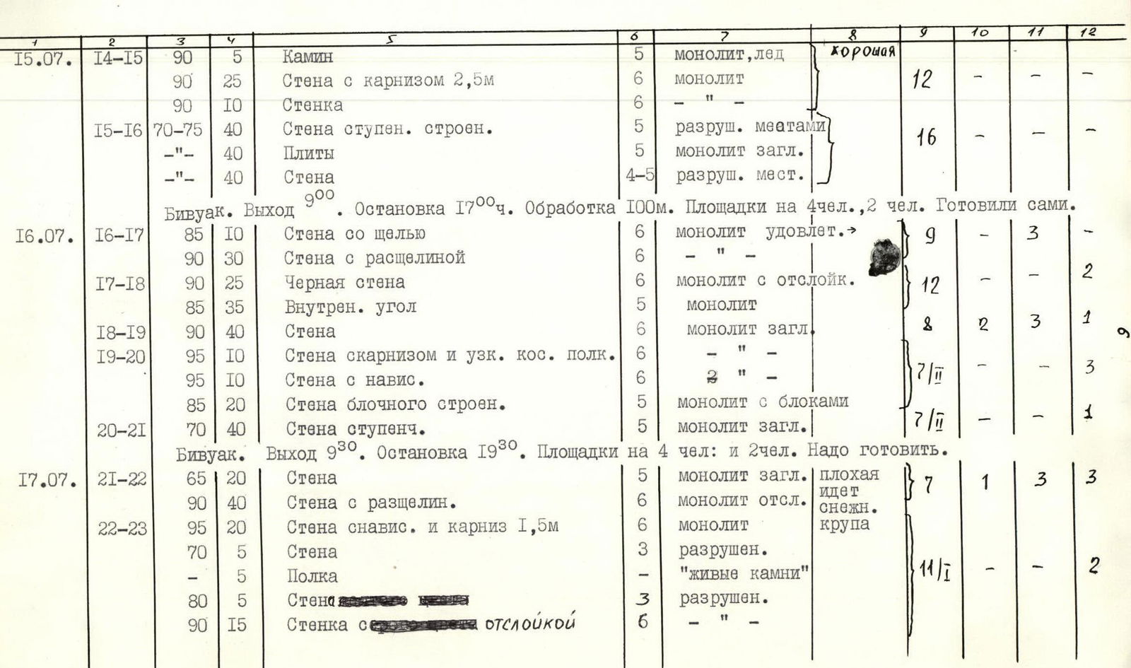
| 15.07 | R14–R15 | 90° | 5 m | chimney | 5 | monolith, ice | good | ||||
| 90° | 25 m | wall with a 2.5 m cornice | 6 | monolith | – | 12 | |||||
| 90° | 10 m | wall | 6 | monolith | – | ||||||
| R15–R16 | 70–75° | 40 m | wall of stepped structure | 5 | partially destroyed | – | 16 | ||||
| 70–75° | 40 m | slabs | 5 | monolith smoothed | – | ||||||
| 70–75° | 40 m | wall | 4–5 | partially destroyed | – | ||||||
| Bivouac. Departure at 9:00. Stop at 17:00. Processing 100 m. Platforms for 4 people and 2 people. Prepared by ourselves. | |||||||||||
| 16.07 | R16–R17 | 85° | 10 m | wall with a slit | 6 | monolith satisfactory | – | 9 | 3 | ||
| 90° | 30 m | wall with a crevice | 6 | monolith | – | ||||||
| R17–R18 | 90° | 25 m | black wall | 6 | monolith with exfoliation | – | 12 | ||||
| 85° | 35 m | inner corner | 5 | monolith | – | ||||||
| R18–R19 | 90° | 40 m | wall | 6 | monolith smoothed | – | 8 | 2 | 3 | 1 | |
| R19–R20 | 95° | 10 m | wall with a cornice and a narrow oblique ledge | 6 | monolith smoothed | – | |||||
| 95° | 10 m | wall with an overhang | 6 | monolith smoothed | – | 7 | 3 | ||||
| 85° | 20 m | wall of block structure | 5 | monolith with blocks | – | ||||||
| R20–R21 | 70° | 40 m | stepped wall | 5 | monolith smoothed | – | 7 | 1 | |||
| Bivouac. Departure at 9:30. Stop at 19:30. Platforms for 4 people and 2 people. Need to prepare. | |||||||||||
| 17.07 | R21–R22 | 65° | 20 m | wall | 5 | monolith smoothed | bad | 7 | 1 | 3 | 3 |
| 90° | 40 m | wall with a crevice | 6 | monolith exfoliating | snow sleet | ||||||
| R22–R23 | 95° | 20 m | wall with an overhang and a 1.5 m cornice | 6 | monolith | – | |||||
| 70° | 5 m | wall | 3 | destroyed | – | 11 | 1 | 2 | |||
| – | 5 m | ledge | – | "live stones" | – | ||||||
| 80° | 5 m | wall | 3 | destroyed | – | ||||||
| 90° | 15 m | wall with exfoliation | 6 | destroyed | – | ||||||
| R23–R24 | 85° | 15 m | wall of yellow color | 5 | destroyed | cold, snowing | 5 | ||||
| 90° | 15 m | wall of gray color | 5 | destroyed | – | ||||||
| R24–R25 | 80° | 30 m | slab | 5 | monolith | – | |||||
| 90° | 10 m | wall | 5 | monolith | – | 12 | 5 | ||||
| 90° | 5 m | wall with water | 5 | monolith | – | ||||||
| 75° | 20 m | slab | 5 | monolith | – | ||||||
| 75° | 15 m | wall with a chimney filled with ice | 5 | monolith | – | ||||||
| R25–R26 | 60° | 20 m | slope | 3 | firn | – | |||||
| 85° | 5 m | wall | 5 | ice | – | ||||||
| 20° | 100 m | slope | 1 | firn | – | ||||||
| Departure at 8:00. Summit reached at 17:30. Stop at the bivouac on the descent to Rovny Glacier. (simultaneously) |
Brief explanation of the table of main characteristics of the ascent route
Day 1. Ascent up a snowy slope to an ice bridge across the bergschrund, crossing, and ascent to the right-up under the wall. The slope is separated from the wall by a 1.5 m wide randkluft (R0–R1). The ascent begins along a steep exfoliation, turning into a chimney with a ledge. From the ledge upwards along a smooth wall to a wide ledge under an overhanging rock, from the ledge a traverse to the left under a huge outer corner with a smooth right face in its lower part. The ascent goes along the left side of the corner. Climbing is very difficult, ladders are used, the number of holds and cracks is limited. After 45 m — a narrow inclined ledge (1.5 m), on which a belay point is organized. Further to the right along the edge of the outer corner, ladders are used. Processing is completed. Descent to the glacier.
Day 2. Ascent of the processed part of the route. Traverse to the left 7 m along smoothed sheer rocks with an entrance to the inner corner. Climbing is very difficult. The inner corner leads to a detritus ledge going to the right upwards, interrupted by sheer walls. The inclined ledge is replaced by a horizontal ledge, along which the path goes to the right under the slabs. Along the slabs, ascent upwards to the base of the inner corner with an overhanging left part (R3–R4). Along the corner straight up under a rock cornice. 12 m before the cornice, the right face of the corner flattens to 80°, forming a slab along which the movement continues to the cornice. The cornice is passed on the right (R4–R5), further up to a sheer inner corner with two new cornices with an overhang of 1.5 and 1 m. The cornices are passed head-on with the help of ladders and I.T.O. The corner leads to a small square ledge, above which lies a "rusty" slab with a cornice (R5–R6). Along the sheer wall, into which the slab turns, the path goes to the left upwards 15 m, where the cornice overhang is 1.5 m. Ladders. Climbing is very difficult. Chocks. Further along the inner corner to a rock ridge (R6–R7). The ridge turns into a crest, going across a large ledge, cut by couloirs to the beginning of a new wall. The crest is mainly snow-ice and sheer walls (R7–R8). Bivouac. Movement along the crest is alternating, then to the wall of stepped structure. Rockfall prone! After the wall, the path leads through a chimney, which leads to an oblique ledge covered with snow (R8–R9). From the ledge, movement along the inner corner, which ends with a cornice. Further, an inclined ledge leads to the right under a sheer wall. The wall is closed by a 2nd cornice (overhang 2.5 m). Above the cornice is a ledge (R9–R10), further along the wall (3 m) entrance to a smooth inner corner with a small number of holds. Ladders, chocks. After the corner, a wall ending with a narrow ledge (R10–R11). Wall 5 m. The inner corner is heavily destroyed. Wall 15 m, few holds.
Day 14. Further along the inner corner, partially destroyed, in the marble belt with two cornices. Climbing is very difficult. Ladders, chocks. The corner leads to a steep wall with good holds (R12–R13). Further along a strongly destroyed wall of stepped structure and ends in the upper part with two steep ledges. Bivouac. From the bivouac straight up along a chimney filled with ice, then along a wall with an exit under a cornice made of marble (2.5 m). The cornice is passed to the left upwards with the use of ladders. Above the cornice is a sheer wall (R14–R15), further along a steep, partially destroyed, stepped wall. The wall turns into smoothed slabs. A destroyed wall leads to a yellow belt. Bivouac. Along the yellow belt, ascent along a slit to a ledge, further up along a sheer wall. Climbing is difficult (R16–R17). The wall turns into a smooth, steep scale exfoliations 25 m wall of the black belt. The difficulty of climbing increases. The black belt is replaced by a yellow one, which is overcome along the corner and further to the next black belt (R17–R18). Along the sheer smooth wall of the black belt to a cornice (1.5 m). Ladders, bolt pitons. The cornice is passed straight head-on. Further, a narrow oblique ledge goes under an overhanging rock to the right upwards. Ladders, bolt pitons. Having reached the yellow belt, we go to the left upwards along a wall composed of blocks (R19–R20). Further, the path goes along a wall, partially with sheer smoothed walls 5–10 m high, under a black sheer wall. Bivouac.
Day 5. A 15 m crack along the wall. Further along a crevice, the path leads to a small ledge (R21–R22). Ladders, chocks. Above the ledge is a wall without holds and cracks, ending with a cornice. After the cornice, a wall, ending with a narrow ledge. Along destroyed rocks to the right upwards to a wide strip, which crosses the wall horizontally. Along the ledge, a traverse to the right 10 m under a wall with exfoliation, along which upwards to the beginning of yellow rocks (R22–R23). Climbing is difficult, ladders, chocks, destroyed rocks. Along the yellow wall 15 m to the left upwards to the gray rock belt. Rocks are destroyed, climbing is difficult, requires extreme caution and thorough belay. Along the gray rocks with the use of ladders, the path goes to the right upwards to the next belt of yellow rocks. To the left upwards along a slab under a sheer wall with a cornice. Climbing is difficult, no cracks. Sheer wall with water. Smoothed slabs, a chimney with ice, go to the left. Traverse to the left and exit under a 3-meter wall (R24–R25). After the wall, exit to a firn slope, ending with a 6-meter ice wall. Steps. Exit to a snowy slope and along it to the summit. Descent along the slope to Rovny Glacier. Bivouac. Further descent to Dridzh Uglu valley.
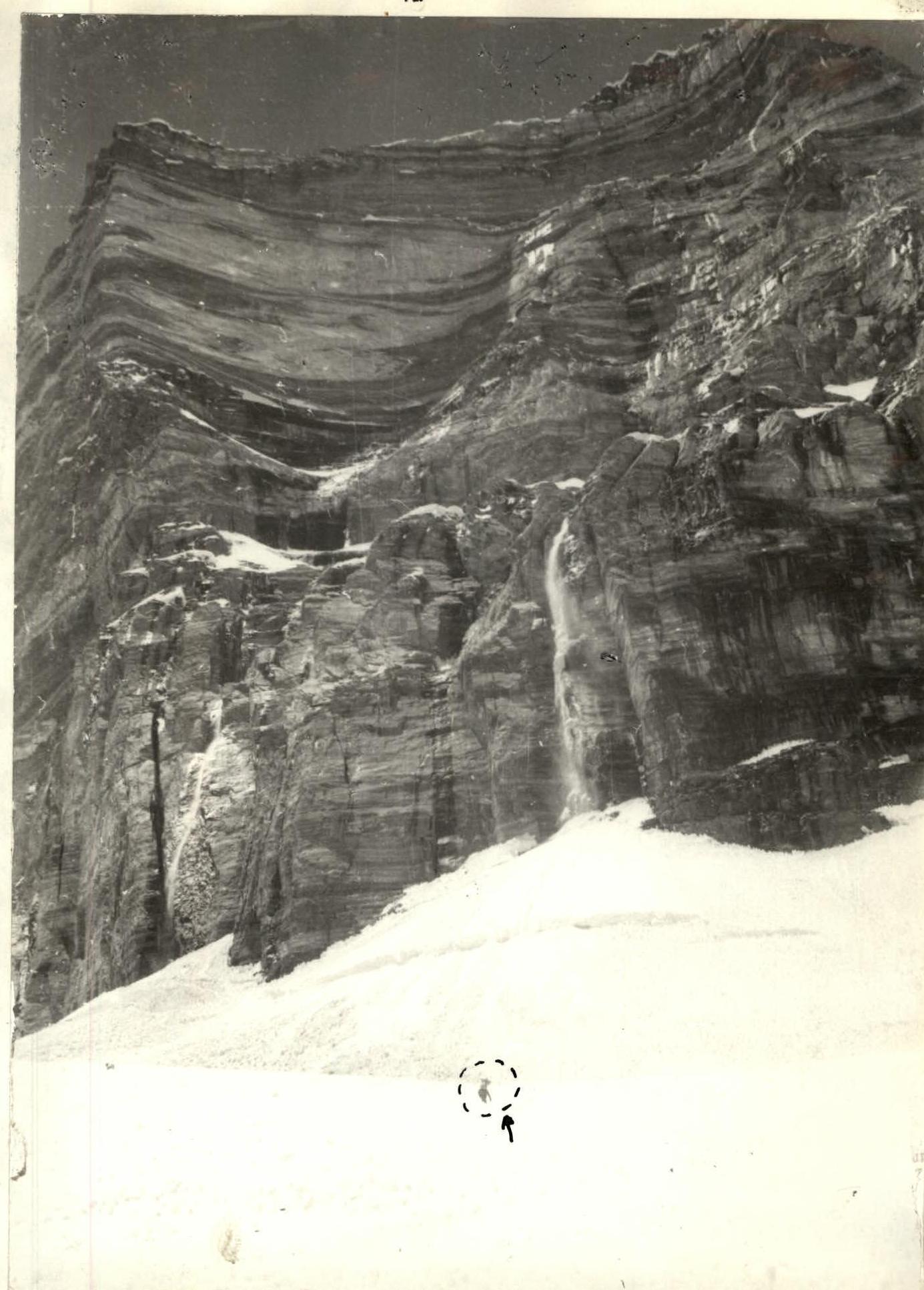
Approach to the wall
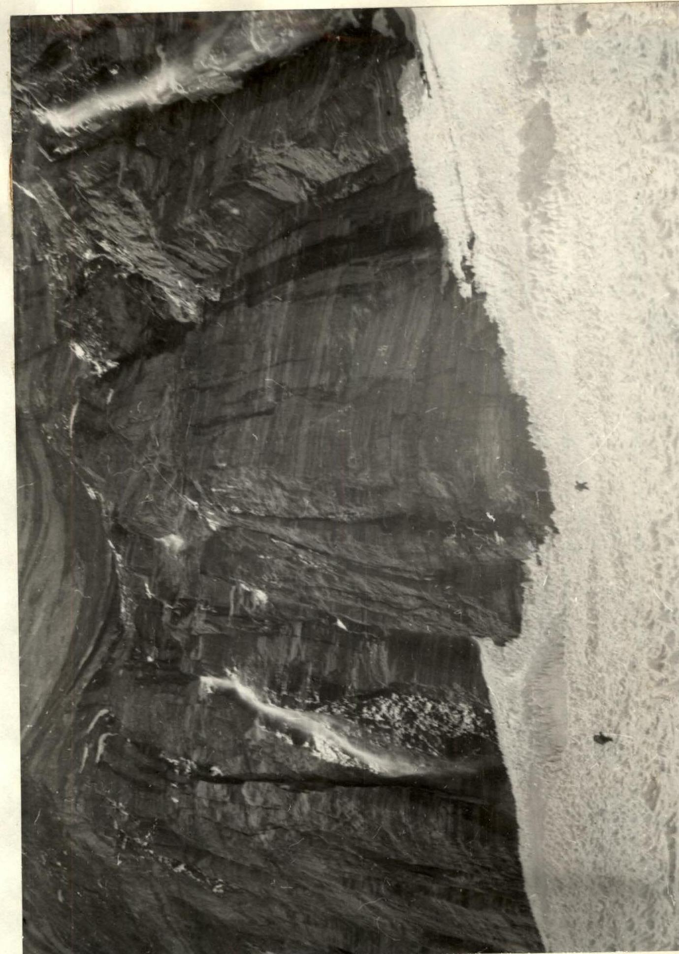
Section R0–R3. Lower part of the wall.
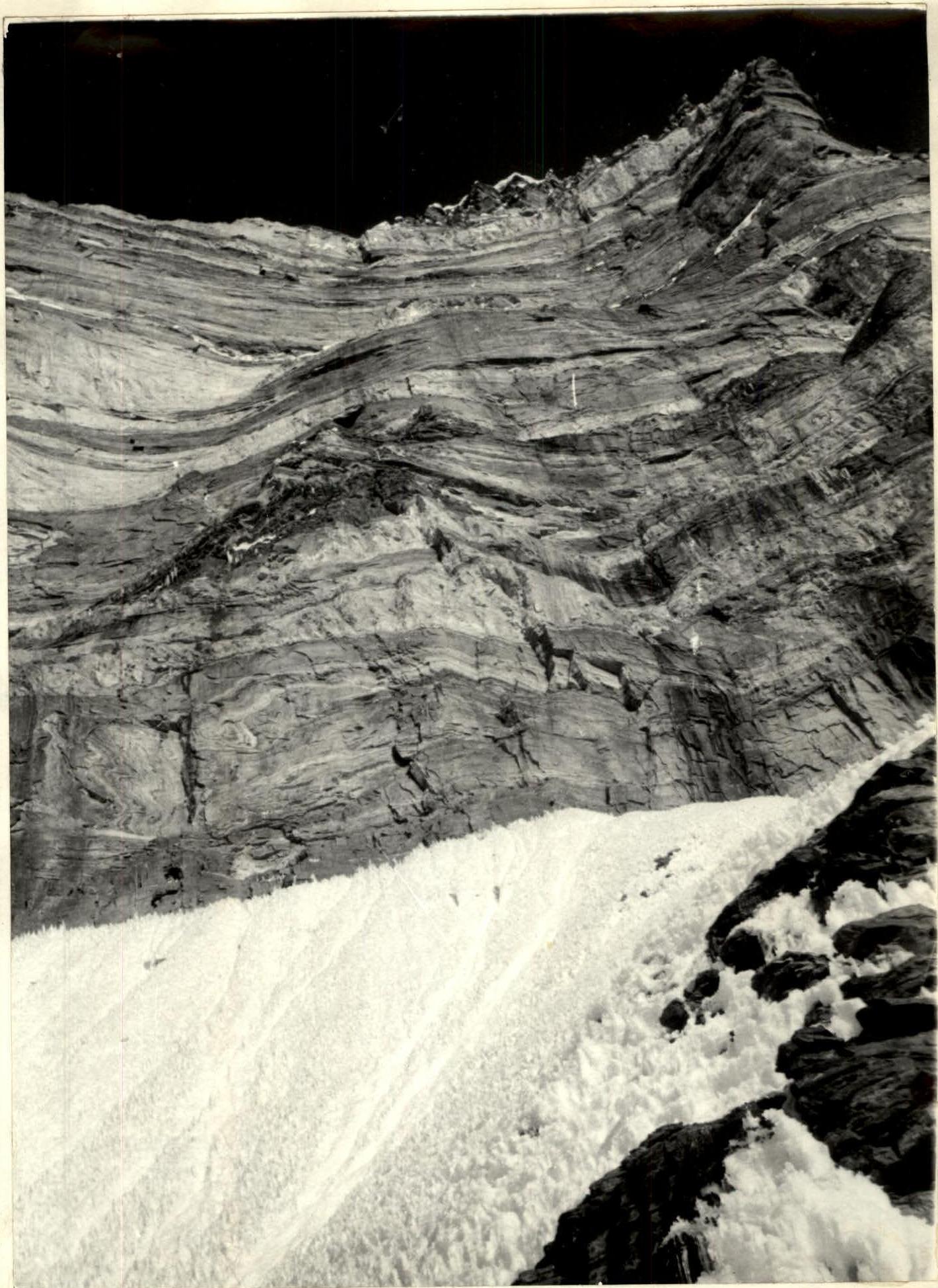
Photo from bivouac №1. Upper part of the wall — sections R8–R26.