Climbing Passport
- Climbing category — high-altitude and technical.
- Climbing area: South-Western Pamir, Shakhdarin Range.
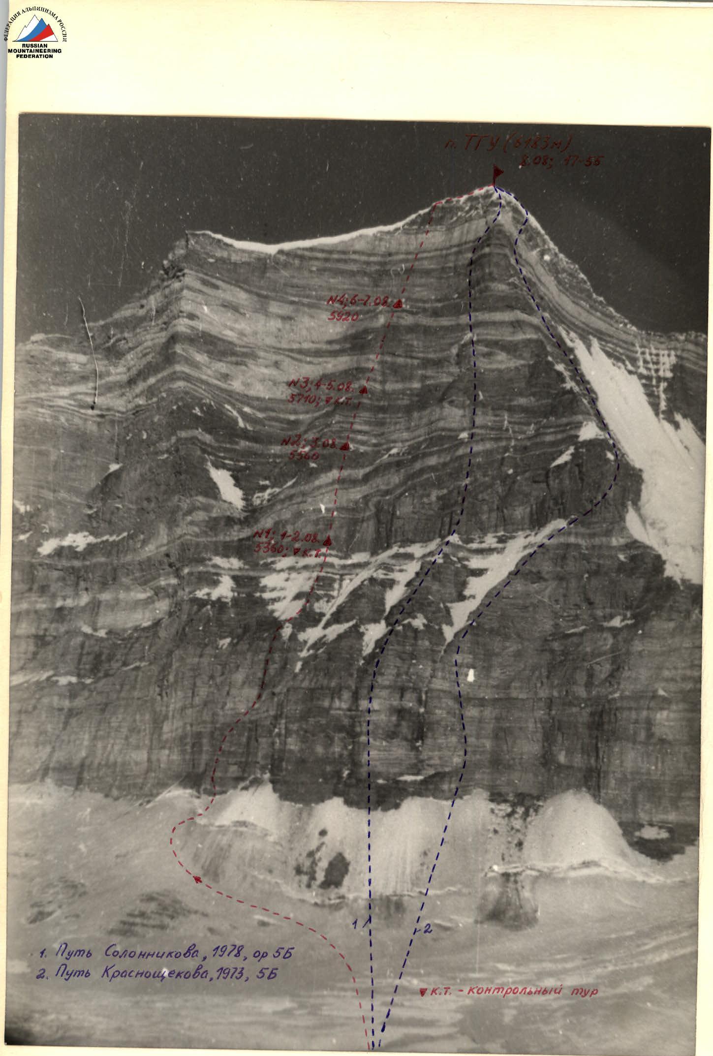
- Peak, its height, climbing route — TGU peak, 6183 m, center of the W wall.
- Proposed difficulty category — 6B.
- Route characteristics: height difference 1240 m. length of sections 5–6 km tr 1018 m average steepness 78° steepness of the most difficult sections 82–84°.
- Number of pitons: for belaying, including for creating ITDs
| rock | ice | bolted | |
|---|---|---|---|
| 246 | 1 | 29 | |
| 80 | 28 |
- Number of walking hours: 100 h 30 min.
- Number of nights and their characteristics: seven, lying down, at bivouac site № 1, 2 uncomfortable nights.
- Surname, name, patronymic of the leader, participants, and their qualification Popenko Yuri Stepanovich, MS. Aigistov Gleb Andreevich, MS. Solomatov Boris Stepanovich, MS. Silchenko Vasily Petrovich, CMS.
- Team coach: Ilyinsky E.T.
- Date of departure to the route and return: July 27, 1978 – August 10, 1978.
5. Table of main characteristics of the climbing route
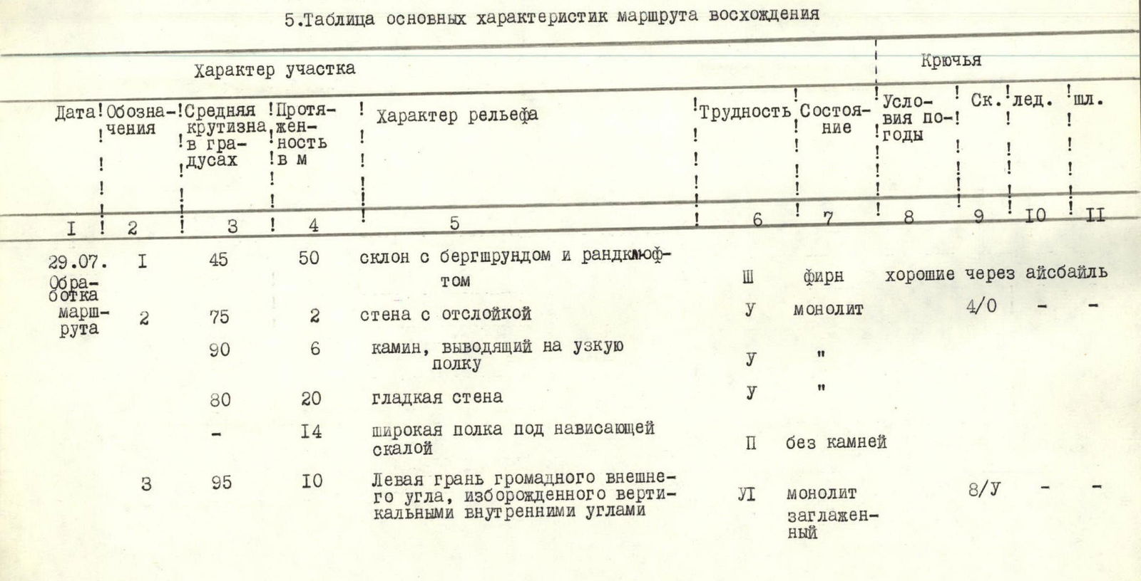
| Date | Designation | Average steepness, in degrees | Length in m | Terrain character | Difficulty | State | Conditions by year | Rock Pitons | Ice Pitons | Bolted Pitons |
|---|---|---|---|---|---|---|---|---|---|---|
| July 29 | R1 | 45 | 50 | slope with bergschrund and randkluft | 3 | firn | good through ice axe | |||
| R2 | 75 | 2 | wall with delamination | 5 | monolith | 4/0 | - | - | ||
| 90 | 6 | chimney leading to a narrow ledge | 5 | «"» | ||||||
| 80 | 20 | smooth wall | 5 | «"» | ||||||
| - | 14 | wide ledge under overhanging rock | 2 | no stones | ||||||
| R3 | 95 | 10 | Left face of a huge outer corner with vertical inner corners | 6 | monolith smoothed | 8/1 | ||||
| R4 | 90 | 30 | «"» | 6 | «"» | |||||
| 90 | 40 | edge of outer corner | 6 | «"» | 7/4 | - | - |
Processing started at 13:00, finished at 20:00. Overnight stay on the moraine of Zugvand glacier under the 5200 pass.
| July 30 | R5 | 90 | 8 | wall (traverse) | 6 | monolith smoothed | good 4/1 | - | - | |
|---|---|---|---|---|---|---|---|---|---|---|
| 90 | 12 | inner corner | 6 | «"» | ||||||
| 50 | 20 | ledge with sheer walls | 3 | with "live" stones | ||||||
| R6 | - | 10 | horizontal ledge | - | «"» | 5/0 | - | - | ||
| 70 | 30 | slabs | 5 | monolith smoothed | ||||||
| R7 | 90 | 30 | inner corner | 6 | monolith | 8/0 | - | |||
| 75 | 10 | slab | 5 | «"» | ||||||
| Aug 1 | R8 | 90 | 25 | inner corner with cornices 1.5 m and 1.0 m | 6 | monolith | 7/4 | |||
| 75 | 15 | slab | 5 | «"» |
Processing started from the point of fixing the rope at 11:30 and finished at 18:00. Overnight stay on the moraine of Zugvand glacier under the 5200 pass.
| Date | Designation | Average steepness, in degrees | Length in m | Terrain character | Difficulty | State | Conditions by year | Rock Pitons | Ice Pitons | Bolted Pitons |
|---|---|---|---|---|---|---|---|---|---|---|
| Aug 1 | R9 | 90 | 15 | wall | 6 | destroyed | good 10/3 | - | ||
| 95 | 5 | cornice with 1.5 m outreach | 6 | destroyed | «"» | |||||
| 80 | 10 | inner corner | 5 | «"» | ||||||
| 50 | 10 | ridge | 3 | «"» | ||||||
| R10 | 45 | 160 | ridge | 3–4 | ice, destroyed rocks | through ledges | ||||
| R11 | 70 | 10 | wall of stepped structure | 5 | destroyed | 5/0 | - | - | ||
| 90 | 15 | chimney | 5 | destroyed | - | |||||
| - | 15 | oblique ledge (traverse) | sand |
Departure from the bivouac on Zugvand glacier at 6:00. Work on the route started at 8:00. Stop at bivouac at 21:30. Bivouac № 1 set up on an oblique ledge covered with sand at the end of section R11.
Processing started at 11:00, finished at 18:00. Overnight stay at bivouac № 1.
| Date | Designation | Average steepness, in degrees | Length in m | Terrain character | Difficulty | State | Conditions by year | Rock Pitons | Ice Pitons | Bolted Pitons |
|---|---|---|---|---|---|---|---|---|---|---|
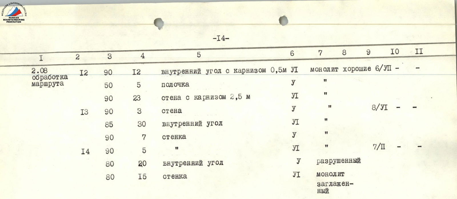
| Aug 2 | R12 | 90 | 12 | inner corner with 0.5 m cornice | 6 | monolith | good 6/6 | - | - | |
| 50 | 5 | small ledge | 5 | «"» | ||||||
| 90 | 23 | wall with 2.5 m cornice | 6 | «"» | ||||||
| R13 | 90 | 3 | wall | 5 | «"» | 8/6 | - | - | ||
| 85 | 30 | inner corner | 6 | «"» | ||||||
| 90 | 7 | wall | 5 | «"» | ||||||
| R14 | 90 | 5 | «"» | 6 | «"» | 7/2 | - | - | ||
| 80 | 20 | inner corner | 5 | destroyed | ||||||
| 80 | 15 | wall | 6 | monolith smoothed |
Processing started at 11:00, finished at 18:00. Overnight stay at bivouac № 1.
| Date | Designation | Average steepness, in degrees | Length in m | Terrain character | Difficulty | State | Conditions by year | Rock Pitons | Ice Pitons | Bolted Pitons |
|---|---|---|---|---|---|---|---|---|---|---|
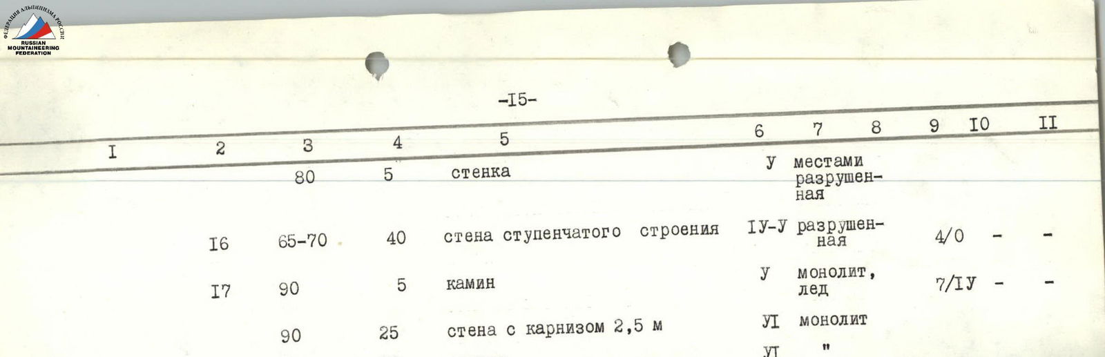
| Aug 3 | R15 | 90 | 35 | inner corner with 1.0 and 1.5 m cornices | 6 | partially destroyed | good 9/6 | - | - | |
| 80 | 5 | wall | 5 | partially destroyed | ||||||
| R16 | 65–70 | 40 | wall of stepped structure | 4–5 | destroyed | 4/0 | - | - | ||
| R17 | 90 | 5 | chimney | 5 | monolith, ice | 7/4 | - | |||
| 90 | 25 | wall with 2.5 m cornice | 6 | monolith | ||||||
| 90 | 10 | wall | 6 | «"» |
Departure from bivouac № 1 at 8:00, end of work by the first on the route at 18:00. Overnight stay at bivouac № 2, set up on the upper steep ledge at the end of section R16. The platform for the tent was built from stones over 2 h 30 min.
| Date | Designation | Average steepness, in degrees | Length in m | Terrain character | Difficulty | State | Conditions by year | Rock Pitons | Ice Pitons | Bolted Pitons |
|---|---|---|---|---|---|---|---|---|---|---|
| Aug 4 | R18 | 70–75 | 40 | wall of stepped structure | 5 | partially destroyed | good 5/0 | - | - | |
| R19 | 70–75 | 40 | slabs | 5 | monolith smoothed | 5/0 | - | - | ||
| R20 | 70–75 | 40 | walls of stepped structure | 4–5 | partially destroyed | 4/0 | - | - |
Departure from bivouac № 2 at 9:00, work by the first on the route finished at 21:00. Overnight stay at bivouac № 3, set up at the end of section R20. The platform was built from stones.
| Date | Designation | Average steepness, in degrees | Length in m | Terrain character | Difficulty | State | Conditions by year | Rock Pitons | Ice Pitons | Bolted Pitons |
|---|---|---|---|---|---|---|---|---|---|---|
| Aug 5 | R21 | 85 | 10 | wall with a gap | 5 | monolith | 6/6 | - | - | |
| 90 | 30 | wall with a crevice | 6 | «"» | ||||||
| R22 | 90 | 20 | black wall | 6 | monolith with delamination | 3/5 | - | - | ||
| R23 | 85 | 40 | inner corner | 5 | monolith | 4/4 | - | - | ||
| R24 | 90 | 40 | wall | 6 | monolith smoothed | good 3/5 | 0/6 | - | ||
| R25 | 95 | 10 | wall with cornice and narrow oblique ledge | 6 | «"» | 7/0 | - | 1/6 | ||
| 95 | 10 | wall with overhang | 6 | «"» |
Departure for processing from bivouac № 3 at 8:00, end of processing at 20:00. Overnight stay at bivouac № 3.
| Date | Designation | Average steepness, in degrees | Length in m | Terrain character | Difficulty | State | Conditions by year | Rock Pitons | Ice Pitons | Bolted Pitons |
|---|---|---|---|---|---|---|---|---|---|---|
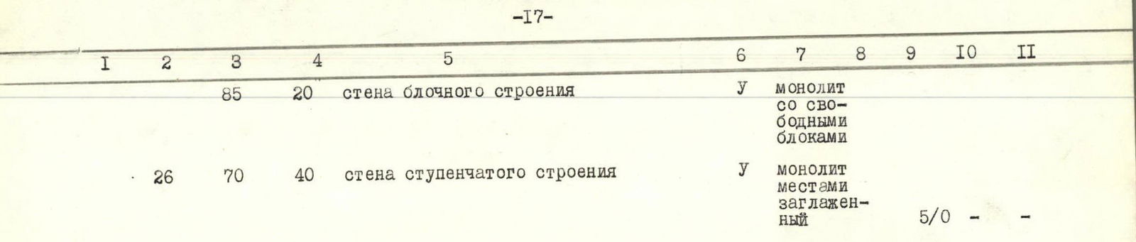
| Aug 6 | R26 | 85 | 20 | wall of blocky structure | 5 | monolith with free blocks | ||||
| 70 | 40 | wall of stepped structure | 5 | monolith partially smoothed | 5/0 | - | - | |||
| R27 | 65–70 | 20 | wall of stepped structure | 3–4 | destroyed | good up to 15° 4/0 | - | - | ||
| R28 | 90 | 40 | wall with crevice | 6 | monolith with delamination | cold later, feet get cold | 2/6 | - | 0/1 |
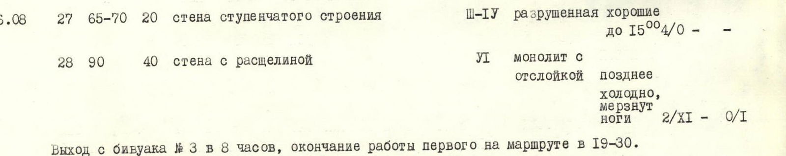
Departure from bivouac № 3 at 8:00, end of work by the first on the route at 19:30. Overnight stay at bivouac № 4 at the end of section R26. The platform for the tent was built over 3 hours.
| Date | Designation | Average steepness, in degrees | Length in m | Terrain character | Difficulty | State | Conditions by year | Rock Pitons | Ice Pitons | Bolted Pitons |
|---|---|---|---|---|---|---|---|---|---|---|
| Aug 7 | R29 | 95 | 20 | wall with overhang and 1.0 m cornice in the end | 6 | monolith | good until 15:00. Cold afterwards, feet get cold 2/0 | 0/6 | - | |
| 70 | 5 | stepped wall | 3 | destroyed | live stones | |||||
| - | 5 | ledge | - | «"» | ||||||
| 80 | 5 | wall | 3 | destroyed | ||||||
| - | 10 | wide ledge (traverse) | - | live stones | ||||||
| R30 | 90 | 15 | wall with delamination | 6 | monolith with delamination | 8/4 | - | |||
| 85 | 10 | wall | 5 | destroyed | ||||||
| 90 | 15 | wall | 5 | «"» |
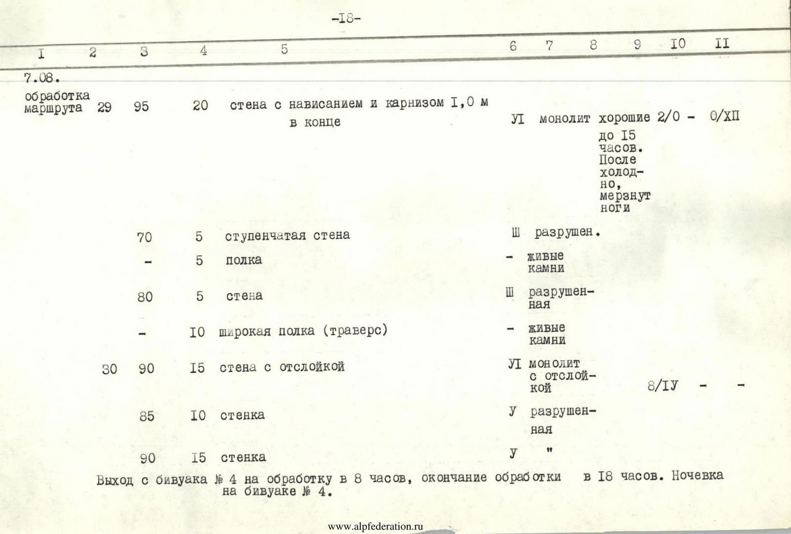
Departure from bivouac № 4 at 8:00, ascent to the summit at 18:55. Overnight stay during descent on Rovny glacier.
| Date | Designation | Average steepness, in degrees | Length in m | Terrain character | Difficulty | State | Conditions by year | Rock Pitons | Ice Pitons | Bolted Pitons |
|---|---|---|---|---|---|---|---|---|---|---|
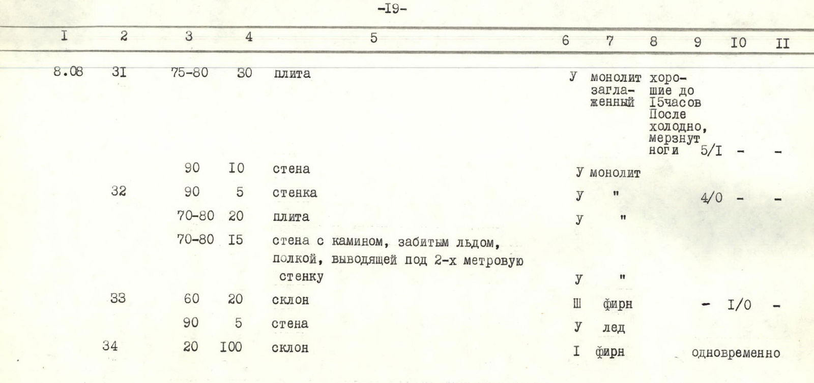
| Aug 8 | R31 | 75–80 | 30 | slab | 5 | monolith smoothed | good until 15:00. Cold afterwards, feet get cold 5/1 | - | - | |
| 90 | 10 | wall | 5 | monolith | ||||||
| R32 | 90 | 5 | wall | 5 | «"» | 4/0 | - | - | ||
| 70–80 | 20 | slab | 5 | «"» | ||||||
| 70–80 | 15 | wall with a chimney filled with ice, ledge leading under a 2-meter wall | 5 | «"» | ||||||
| R33 | 60 | 20 | slope | 3 | firn | 1/0 | - | |||
| 90 | 5 | wall | 5 | ice | ||||||
| R34 | 20 | 100 | slope | 1 | firn | simultaneously |
6. Explanations for the table of main route characteristics
July 29. First day of processing. Ascent up the firn slope to the ice bridge over the bergschrund, crossing the bergschrund to the right, and then ascent to the right and upwards under the wall. The slope is separated from the wall by a randkluft about 1 m wide (section R1). Transition under the wall. Further ascent starts up a steep delamination, turning into a chimney. Above the chimney is a narrow ledge (section R2). From the ledge, movement goes straight up the smooth wall to a wide ledge under an overhanging rock, along which there is a move to the left under the overhanging lower part of a huge outer corner (section R2, photo 3). The right face of the corner is smoothed, the left has a number of small inner corners, along which the ascent is carried out upwards (section R3, photo 3). Climbing is very difficult, mainly on friction, ladders are used, the number of holds and cracks is limited. After 40 m, there is a narrow inclined ledge (1.5 m), where a belay station is organized. From the ledge, there is a move to the right and upwards to the edge of the outer corner, along which the movement continues upwards with the use of ladders (section R4). Using a small step, a belay station is organized. Processing is finished.
July 30. Second day of processing. Sections processed on July 29 are passed. From the point of fixing the rope, a traverse to the left 8 m along smoothed sheer rocks and entry into an inner corner (section R5). A ladder is used. The inner corner leads to a stony ledge, interrupted by sheer walls, stretching to the right and upwards (section R5). The inclined ledge is replaced by a horizontal one, along which there is a move to the right under the slabs. Ascent steeply to the right and upwards along the slabs (section R6) to the base of an inner corner with an overhanging left face. The path goes straight up along the corner under a rock cornice (section R7). Not reaching 10 m to the cornice, the right face of the corner flattens to 75°, forming a slab, along which the movement continues (section R7). Bypassing the first cornice from the right, an inner corner with two new cornices, having an outreach of 1.5 and 1.0 m, extends upwards again (section R8). The cornices are overcome head-on using a ladder on ITDs. The corner leads to a square (1.5×1.5 m) ledge, above which lies a slab of rusty color with a powerful cornice overhanging it (section R8). After passing 15 m along the slab, processing ends.
Aug 1. Start of ascent. Sections R1–R8 processed on July 29–30 are passed. From the point of fixing the rope, along the sheer wall, into which the slab turns, there is a move to the left and upwards 15 m, where the cornice outreach is the smallest (1.5 m). The cornice is overcome using a ladder (photo 4). Climbing is very difficult — the number of holds and cracks is limited. Above the cornice is an inner corner, which leads to a rock ridge of stepped structure with a steepness of 50° (section R9). Further, the ridge turns into a crest, running across a giant ledge, cut by couloirs, straight to the beginning of the main wall (section R10). The crest is interrupted by several sheer walls and is largely covered with ice and firn. Movement is alternating, sometimes simultaneous with belaying through ledges. From the crest, there is a transition to a wall of stepped structure with destroyed rocks. After the wall, there is an entry into a chimney, which leads to an oblique ledge covered with a thick layer of sand (section R11). Here, the first bivouac is organized.
Aug 2. Processing of the route above bivouac № 1. From the ledge, entry into an inner corner (photo 5), which ends with a cornice with an outreach of 0.5 m. Above the cornice, a narrow inclined ledge leads to the right under a sheer wall. The wall is closed by a second cornice with an outreach of 2.5 m (section R12). Above the cornice, a ledge allows for organizing a belay station. From the ledge, along a wall (3 m), entry into an inner corner with a small number of cracks and holds (section R13). Climbing is very difficult. Segmented placements are used. A ladder is continuously used. After the corner, there is again a wall, ending with a narrow ledge, where a belay station is organized (section R13). Again, a wall 5 m, which is overcome with a podsak (support), turning into an inner corner with strongly destroyed rocks. The corner is replaced by a smoothed wall 15 m with a small number of holds and cracks. This wall is overcome by very difficult climbing to the right along a crack by wedging (section R14). Processing ends here.
Aug 3. Sections R12–R14 processed on Aug 2 are passed. Further, the path continues along a partially destroyed inner corner in the marble belt with two cornices, having outcrops of 1.0 and 1.5 m, respectively (photo 6). Climbing is very difficult with the use of a ladder and segmented placements. The corner leads to a steep wall with good holds and cracks (section R15). Further, a strongly destroyed wall of stepped structure stretches (section R16), ending in its upper part with two steep ledges. The upper of these will host bivouac № 2.
From bivouac № 2 on the same day, processing of the wall upwards is carried out. First, a chimney filled with ice is passed, then a wall under an overhanging rock (photo 7) with an exit under a cornice made of marble with an outreach of 2.5 m. The cornice is overcome to the left and upwards using a ladder and placements (section R17). Above the cornice is a sheer wall with a small number of holds and cracks (section R17). Overcoming this wall concludes the processing of the route for the day.
Aug 4. The section processed on Aug 3 is passed. From the point of fixing the rope, the path goes along a steep, partially destroyed wall of stepped structure (section R18), which turns into smoothed slabs with a small number of holds and cracks (section R19). After the slabs, there is again a partially destroyed wall of stepped structure, leading to the yellow belt (section R20), at the base of which bivouac № 3 is planned. From the level of this bivouac, ascent starts along a crack with an exit to a ledge (section R21). From the ledge, the path goes upwards along a sheer wall with a crevice (section R21, photo 8). Climbing is very difficult. The wall of the yellow belt is replaced by an absolutely smooth, scale-covered 20-meter wall of the black belt (section R22, photo 8). The difficulty of climbing increases. The black belt is again replaced by a yellow one, which is overcome along an inner corner, leading to the next black belt (section R23). At the border of these belts, processing of the route on Aug 4 ends.
Aug 5. Processing of the route. Along the sheer smooth wall of the black belt, ascent goes upwards under a rock cornice with an outreach of 1.5 m (section R24, photo 9). Climbing is very difficult, bolted pitons are used, as there are almost no holds and cracks on the wall. The cornice is overcome head-on. Above the cornice, a narrow oblique ledge (4 m) goes under an overhanging rock to the right and upwards. From the ledge to the yellow belt, there is again a wall with an overhang without a single hold and crack, which is overcome using bolted pitons and a belay stance (section R25, photo 10). After exiting to the yellow belt, there is a move to the left and upwards along a wall composed of shapeless blocks, some of which lie freely but quite firmly on their base (section R25). Further, the path goes along a wall of stepped structure, partially with sheer smoothed walls 4–7 m high, under a rock ridge (section R26). A planned bivouac № 4 is expected here. But its organization is a matter for tomorrow, and today processing ends here.
Aug 6. Sections R21–R26 processed on Aug 4–5 are passed to the site of bivouac № 4. From it, a wall of stepped structure with a section of smoothed rocks leads to the black sheer wall (section R27). Along the black wall, a crevice runs vertically upwards, starting 15 m from the foot (section R28, photo 11). The lower part of the wall is covered with large delamination like a shell. Overcoming the delamination required great caution. Further along the crevice, an ascent was made to a small ledge. There was a belay station. Climbing was done using a ladder and placements. Here, the fixing of ropes was carried out, and processing of the route for the day was finished.
Aug 7. Route processing
Above the ledge, there is an absolutely smooth, overhanging wall without a single crack with a cornice at the top 1.0 m (section R29, photo 12). Its passage is carried out on bolted pitons using a belay stance. The smooth wall after the cornice turns into a stepped wall, which ends with a not very wide ledge (section R29). From this ledge, along destroyed rocks, there is an exit to the right and upwards to a wide ledge, crossing the entire wall horizontally (section R29). Along the wide ledge, there is a traverse to the right 10 m under a section of the wall with delamination. Using the delamination for climbing, ascent begins upwards to the belt of yellow rocks (section R30). Climbing is difficult. A ladder is used, and where it is impossible to drive in a piton, placements are used. At the border of yellow and gray rocks, there is a layer of very destroyed rock, crumbling in hands, which significantly complicates the ascent. Along the wall of yellow rocks, there is a move steeply to the left and upwards 10 m to the belt of gray rocks (section R30). The rocks are strongly destroyed, climbing is difficult, requiring special caution. Along the gray rocks, there is a move to the right and upwards 15 m with the use of a ladder to the next belt of yellow rocks (section R30), where under the cornice the rope is fixed, and processing ends.
Aug 8. Sections R27–R30 processed on Aug 6–7 are passed
From the point of fixing the rope, the path goes to the left and upwards along the slab of the yellow belt (section R31, photo 13). Climbing is on friction, the number of holds and cracks is limited. Then the slab turns into a sheer wall 10 m, ending with a niche (section R31). From the niche, slightly to the left, there is an exit to a sheer wall, along which water flows (section R32). With the sun setting, the water freezes, making the passage of this wall more complicated. Behind the wall are smoothed slabs, from which there is a move to the left into a chimney with an icicle. Ascent up the chimney 3 m and traverse to the left along a ledge under a 2-meter wall (section R32). Overcoming it, you find yourself on the firn slope of the pre-summit ridge (section R33). The firn slope ends with a 5-meter ice wall, which is overcome head-on with step cutting (section R33). After overcoming the ice wall, there is an exit to the western gentle firn slope, along which the ascent to the summit is carried out.
Descent on Aug 8–9 is carried out along Rovny glacier to the village of Dridzh, and then on Aug 10, there is an ascent to the base camp at an altitude of 3800 m.
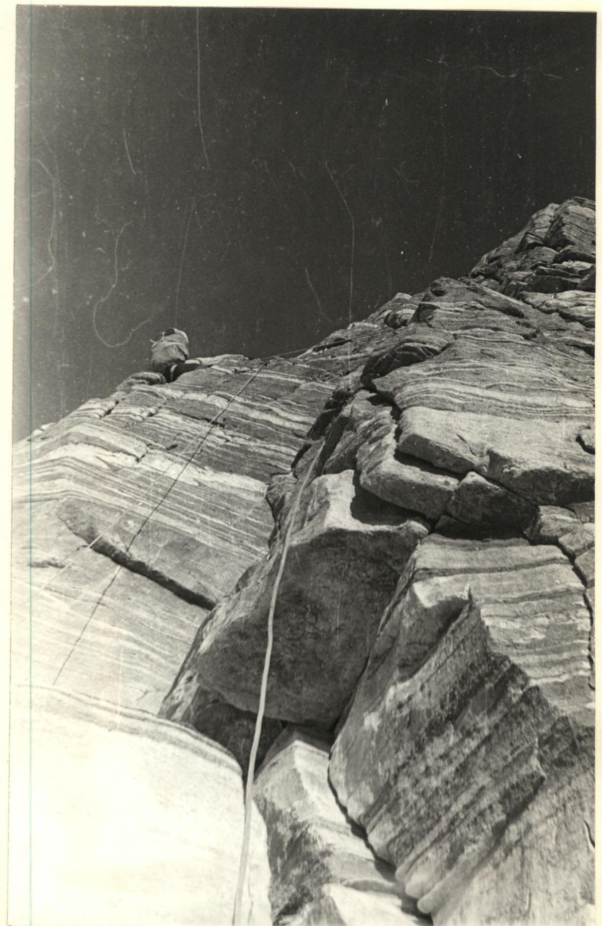 Photo 3. Section R2.
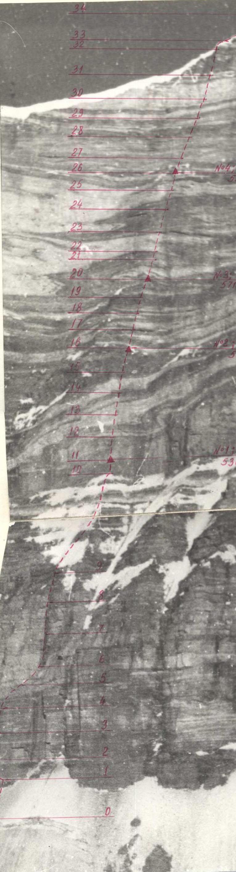
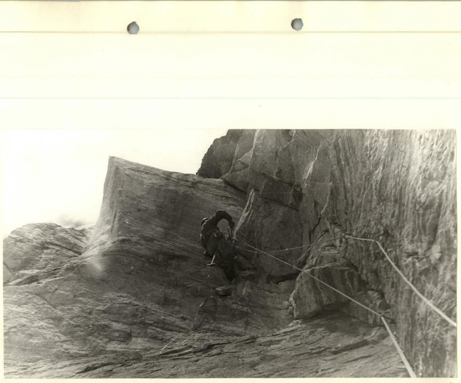
Photo 6. Section R15.
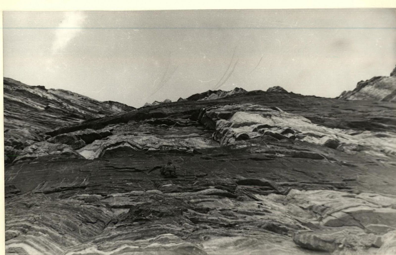
Photo 8. Sections R21–R23.

![img-16.jpeg]({"width":1894,"height":1237,"format":"Jpeg","uri":"https://summitx.info/media/1/3Wh3dnrDkxkeCB8baBw5KrW4zm↗