
List
of the TsS DSO "Trud" team that participated in the country's championship in the class of high-altitude and technical ascents, having climbed the northeast wall of Peak Tajikistan 6565 m.
Participants:
-
- Chunovkin G.A., Master of Sports — team captain
-
- Solonnikov V.A., Master of Sports — deputy captain
-
- Shevchenko Yu.S., 1st category — doctor
-
- Pugachev A.D., Master of Sports — participant
-
- Komarov Yu.I., Master of Sports — participant
-
- Karpov I.B., Candidate for Master of Sports — participant
-
- Nosov A.P., 1st category — participant
Observation group:
-
- Dreitser V.I., Candidate for Master of Sports
-
- Shemeris V.A., 1st category
- Shemeris V.A., 1st category
Profile scheme of the route on the northeast wall of Peak Tajikistan
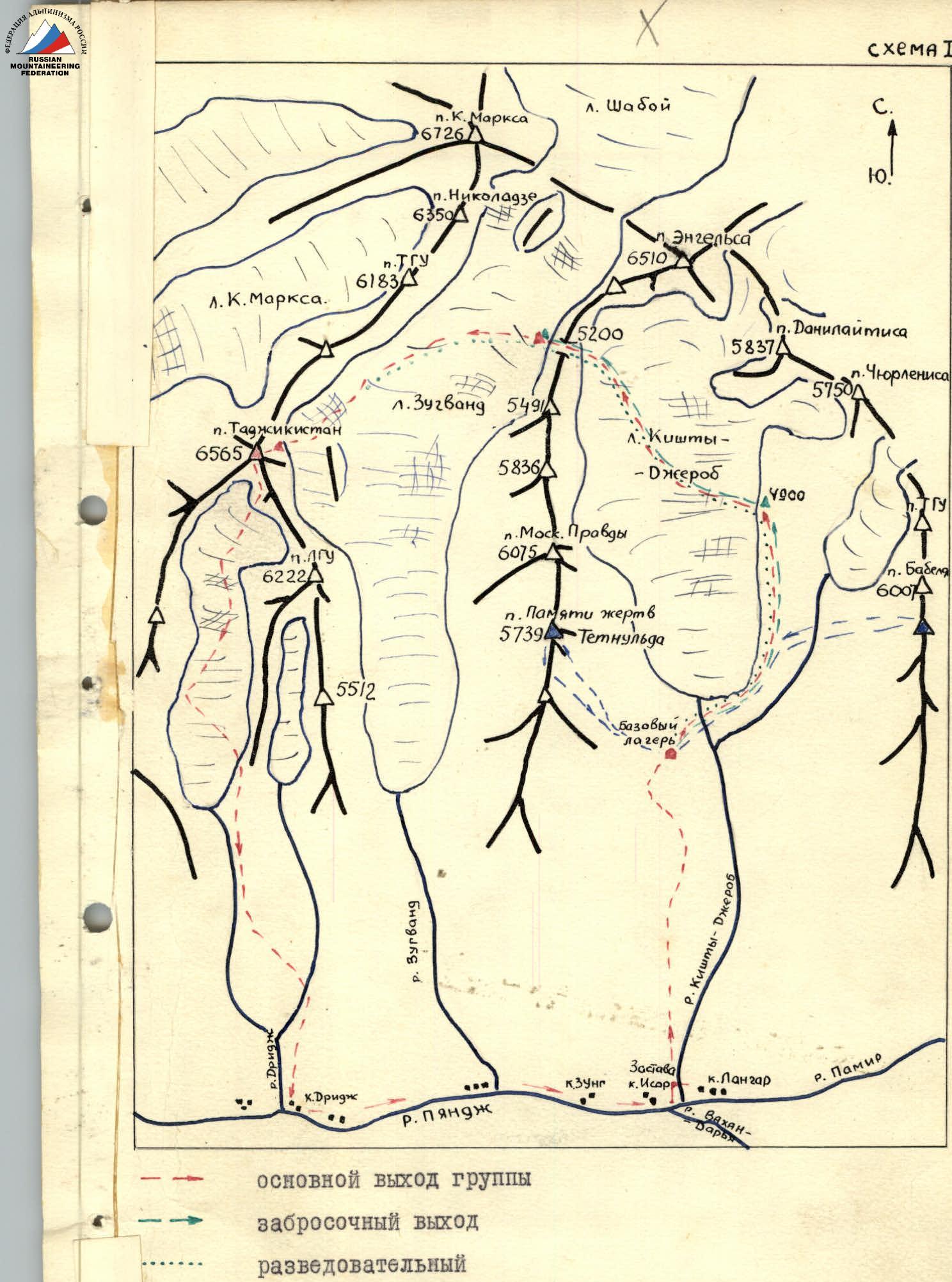
Map-scheme of the ascent area
Peak Tajikistan (6565 m) is located in a spur of the Shakhdarin range in the Southwestern Pamir (see scheme No. 1).
The first ascent was made in 1962 by Savon's group, which gave the name Peak Tajikistan to the conquered summit.
To the east and northeast, the massif of Peak Tajikistan drops off with sheer walls to the Zuvand glacier. The first route from this side was laid in 1966 by climbers from Kabardino-Balkaria, who ascended Peak Tajikistan via the eastern wall. In the 1966 season, this ascent was recognized as the best.
The unconquered northeast wall is a logical and interesting route in sports terms, which is the most challenging path to Peak Tajikistan from the Zuvand glacier (see photo 1).
The wall is lit mainly by oblique sun rays, so, despite the relatively high air temperature in this area, melting occurs very slowly.
In this regard, the danger of ice and snow avalanches, although low, still persists throughout the summer season. Therefore, in the event of an unfortunate choice of route and ascent tactics, the group may find itself in a difficult position.
The expedition's base camp was located in the Kishti-Jerob valley at an altitude of 4000 m, relatively close to the Osh—Lyangar–Khorog highway. At the same time, the organization of a storm camp under the wall of Peak Tajikistan on the Zuvand glacier required the team to make shuttle operations through the 5200 pass (see scheme No. 1).
The Zuvand glacier valley, despite being visited by several expeditions, remains insufficiently explored. The exit from the valley to the Pyandzh River is still unclear.
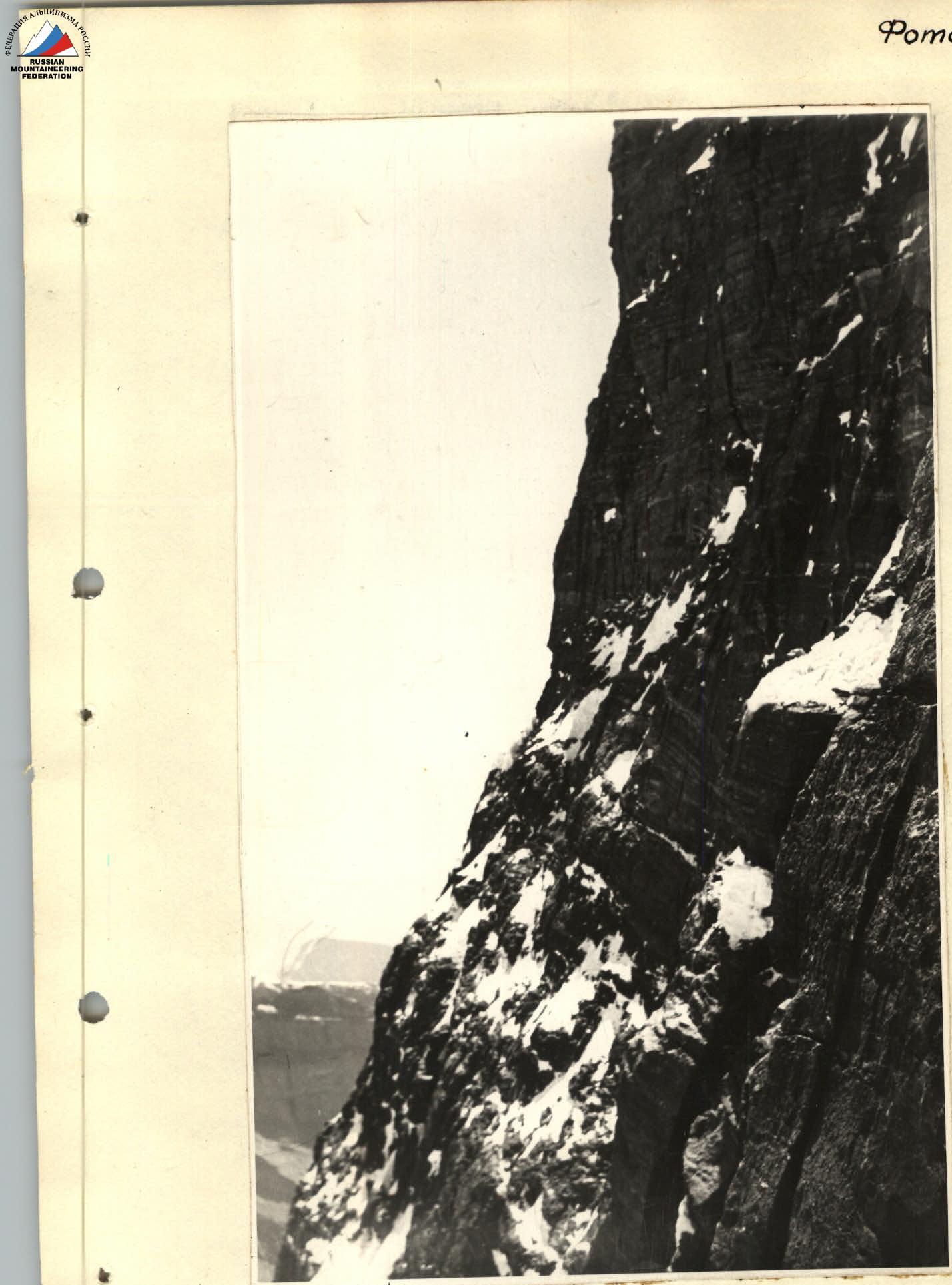
The rock massif of Peak Tajikistan is characteristic of this Southwestern Pamir region.
Hard rocks like granite are relatively rare; softer rocks like shale and sandstone are more common, "polished" by the work of water and wind. Such rocks create particular technical difficulties for the routes.
As is known, the Southwestern Pamir region is distinguished by stable good weather. The season this year was an exception.
During the expedition's work, precipitation fell repeatedly, and it even snowed in the base camp. In this regard, the snow cover on the routes was higher than usual. The team's work plan took into account the need for preliminary familiarization with the area, as all team members were new to this part of the Pamir. The first reconnaissance and acclimatization exit to the high-altitude zone as part of a combined expedition group was made by team members Chunovkin and Shevchenko on July 14–15 (scheme 1). The goal of this exit was to get acquainted with the declared routes and their visual assessment.
As a result of this reconnaissance exit, it became clear that:
- the declared main object — the route to Peak im. "Moskovskoy Pravdy" — should be rejected due to its objective danger (possibility of ice avalanches) under the conditions of this year;
- visual acquaintance with the route to Peak Tajikistan from pass 5200 showed that it is a very interesting and complex route, at the same time quite safe if the path is chosen correctly.
In this regard, the choice was made in its favor.
During the same period, the remaining team members carried out the delivery of food and equipment to the camp at 4900 m on the Kishti-Jerob glacier (see scheme 1).
The second exit was planned for July 17–20. This exit had a complex goal:
- detailed reconnaissance of the route and approach to it;
- delivery of food and equipment to the storm camp on the Zuvand glacier;
- acclimatization of team members.
The group consisted of 7 people, all participants in the upcoming assault. The storm camp was organized on the Zuvand glacier under pass "5200" at an altitude of approximately 5000–5100 m (see scheme 1). Bad weather (heavy snowfall and strong wind) and almost zero visibility delayed the team on July 18–19 in the storm camp.
On July 20, around 11:00, the weather improved. The rope team Chunovkin, Komarov, Karpov crossed the glacier and approached the beginning of the route to Peak Tajikistan (Bergschrund) for reconnaissance purposes (see scheme 1). Due to the abundance of fresh snow that fell during the bad weather, further progress was unsafe, so the rope team returned to the storm camp, and then the entire team descended to the base camp on the same day.
Further acclimatization was obtained by the team members from July 22 to 25 during training ascents to peaks of 5B category of difficulty — Peak Pamyati pogibshikh on Tetnuld (5800 m) and Peak Babel (6007 m). These ascents also aimed to develop technical skills applicable to the conditions of this area.
This concluded the preparatory part of the team's work. In the preliminary application, the route on the northeast wall of Peak Tajikistan was planned to exit to the southeast ridge to the left of the summit. A detailed acquaintance with the route showed that a more safe and logical path would be directly to the summit. The main factor in this choice was the danger of the hanging glacier over the previously planned path (see photo 1). It was further assumed that processing the wall from the "cushion" camps would be целесообразn.
Some characteristic features of the route should be noted:
- The wall has approximately equal steepness throughout — from the snow "cushion" to the summit.
- The height difference of this section is 1500 m.
- The micro-relief of the route is quite monotonous.
- There are very few loose rocks, ledges, or shelves on the route.
- The only type of protection was piton protection.
- Organizing bivouacs presents significant difficulties.
Some general remarks on technique:
- the first climber on the entire route went without a backpack on a double rope;
- only three-step ladders were used;
- on sections: R0–R1; R1–R2; R7–R8; R10–R11; R11–R12; R12–R13; R13–R14; R17–R18; R22–R23; R26–R27; R30–R31; R32–R33; R34–R35; R36–R37; R38–R39; R40–R41; R43–R44 — pulling up backpacks was carried out;
- clamps were widely used for climbing ropes.
The equipment was mostly standard. The most suitable group size for this route is four.
- Helmets are necessary.
- It is sufficient to have 1–2 pairs of crampons.
- When climbing in a large group (6–8 people), it is useful to have an extra rope.
Description of the ascent
July 29. The team consisting of: Chunovkin G.A., Komarov Yu.I., Solonnikov V.A., Pugachev A.D., Shevchenko Yu.S., Karpov I.B., Nosov A.P. left the base camp at 9:00 to assault Peak Tajikistan. After 6 hours of walking, having crossed pass 5200, they reached the storm camp at 5000–5100 m. Overnight stay.
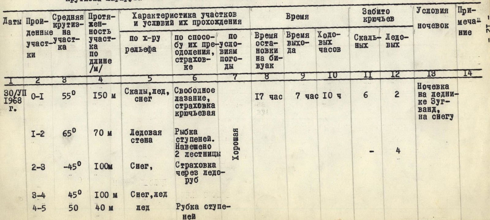
July 30. Departure at 7:00. After 2 hours, we cross the glacier and approach the Bergschrund — the beginning of the route. The upper edge of the Bergschrund is overhanging (2–3 m), so we have to use ice screws and hang two ladders. Further up to the left along the snow at 40–45° — 40 m. Exit through a small rock wall straight up (piton) to an inclined wide shelf. Up the shelf — 20 m. Straight up is a narrow sheer gap about 5 m. Again, an inclined shelf in the upper part, turning into a snow slope with large rocks. Straight up — 100 m (section R0–R1). Steep ice wall — 70 m, in the upper part 15 m almost sheer. Protection through ice screws. In the upper part, we hung ladders. Having passed this ice wall, we exit onto a snow counterfort coming from the northern ridge of Peak Tajikistan. From the counterfort, we descend to the left down along dense snow into the icefall couloir — 100 m. We cross the icefall couloir, exit to its right edge (section R2–R3) and go up it — 100 m (section R3–R4). We cross two horizontal crevices and exit onto inclined snow fields under the northeast wall. We traverse the snow fields (200–250 m) and exit onto a snow "cushion". Here we organize an overnight stay, time 17:00.
July 31 — 8:00. The rope team Chunovkin, Solonnikov, taking 190 m of ropes, went to process the wall. From the overnight stay straight up along the snow slope 80 m (section R6–R7) to a sheer rock wall (15 m). The wall is overcome straight up — to the right. Protection is piton. Difficult sections (R4–R5, R5–R6). Ladders are used. Further 160 m up, with a slight deviation to the left. Rocks. Steepness 65°.
In the upper part, it is possible to organize a semi-reclining overnight stay (section R8–R9). Leaving the ropes, the rope team descended to the overnight stay on the "cushion" by 16:00.
August 1, 8:00. We climb up to the planned overnight stay along the натянутым ropes by 14:00. The rope team Chunovkin, Shevchenko carry out further processing.
From the overnight stay straight up along rocks covered with ice — 40 m, steepness 60°. Protection is piton.
The rock is soft, friable, requiring special care during climbing. Further, the steepness increases and turns into a sheer inner corner (R10). In total, we pass another 60 m. Then, a turn to the right onto a horizontal narrow shelf — 30 m to a sheer inner corner. The rock is sandy. It is necessary to drive in long pitons. Vertical wall of the "red" belt. Length 20 m with overhanging cornices. Steepness 90–100°. Rock — hard shale. Climbing with the help of a belay ledge and ladders. Here, 10 pitons were driven in (section R11–R12).
Further, we exit onto a steep "sandy" ledge, which is overcome by friction. The rock is fine-grained, with a destroyed upper layer. Length 7 m, steepness 75°. 1 piton was driven in (section R12–R13). The "ledge" turns into a smooth steep wall 16 m long, with a steepness of 80–85°. 2 ladders are hung. 4 pitons were driven in (section R13–R14).
From here, the rope team descends 4 ropes down, where everyone sets up a bivouac (18:00). We organize an overnight stay on a shelf, semi-reclining. This is the first control point.
August 2, 7:30. We climb along the previously laid perils, the processing of which was done the day before. Further up along a wide inner corner — up to the right — 65 m. Steepness 60°. Climbing is of medium difficulty, with "live rocks" and friable rock. The inner corner ends in the upper part with a sheer 5-meter wall. 3 pitons were driven in (section R14–R15). Straight up along the wall — 40 m. Average steepness 75°, in the upper part — a sheer 8-meter wall. 5 pitons were driven in (section R15–R16). Steep ice slope 60 m long, ascent up to the right. Steepness 50–56°. On the slope, there are two rock vertical walls 5–7 m. Climbing is difficult. Protection through ice and rock pitons. On the ice — a thin layer of dry snow. Step cutting (30 m). 4 ice and 3 rock pitons were driven in (section R16–R17). The ice slope turns into a sheer 10-meter wall. Difficult climbing, 1 ladder, steepness 85°. 3 pitons were driven in. Hard rock (section R17–R18). The steepness decreases to 75°, ascent 40 m up to the right. 4 rock pitons were driven in. At the end — exit onto a small (50–60 cm wide) shelf, on which 3–4 people can spend the night sitting (section R18–R19). Straight up — a rock wall with a steepness of 80°, 40 m long. Very complex climbing. In the upper part — exit onto a narrow shelf, below to the left — another similar shelf. Here, a sitting bivouac can be organized. It is decided to stop here. 5 pitons were driven in. The rope team continues processing above (section R19–R20). Straight up — 35 m along the wall, steepness 75–80°. Complex bypass of an overhanging ledge on the right. 5 pitons were driven in (section R20–R21). The wall turns into a slope — ice-covered slabs covered with a thin layer of dry snow. Ascent up — to the left — 25 m. Protection through 2 screw ice pitons (section R21–R22). The slope abuts a vertical wall (90–95°), 15 m long, which is overcome along a narrow groove. 2 ladders are hung. 5 pitons were driven in (section R22–R23). From here, we descend 80 m down along the ropes to the overnight stay by 18:30. We settle down for the night on three shelves, sitting, as their width is no more than 0.6 m. Having driven in piton anchors, we stretch tents only over the "ridge". Very uncomfortable, but warm. Here, it is decided to leave the 2nd control point, attaching a can to a piton anchor.
August 3, 1963, 7:30. Rest on such overnight stays is relative. We climb 80 m along the ropes натянутым the day before. Further, 110 m of snow-covered slabs with small 4–6-meter rock walls: complex climbing. Steepness 60–65°. Few footholds; careful protection. 7 pitons were driven in (section R23–R24). Traverse to the right — up, steepness 65°, length 60 m. The character of the rocks — slabs covered with snow. 3 pitons were driven in (section R24–R25). Ascent to the right — up along smooth, hard rocks of a huge inner corner, resembling a mulda, 80 m. Steepness 75°. 5 pitons were driven in (section R25–R26). Further up along a steep (80°) complex wall. 3 ladders are hung. Length 65 m. 8 pitons were driven in (section R26–R27). In the upper part, it is possible to organize overnight stays in two places: on an inclined shelf — 3 people and a "snow ridge" — 4 people. The rope team continues processing above until 17:30. Straight up along a rock counterfort — 80 m. Steepness 60°, 4 pitons were driven in (section R27–R28).
Overnight stay is more successful compared to the previous one. We spent the night semi-reclining.
August 4, 8:00. We climb 80 m along the perils. Further, 100 m up — to the right. Climbing along snow-covered slabs. Steepness 65°. 7 pitons were driven in (section R28–R29). Another 40 m along a rock snow-covered wall at 70°. In the middle part, there is a "red" vertical inner corner (10 m). Ascent up — to the right. 4 pitons were driven in (section R29–R30). Vertical groove (20 m) filled with ice. Difficult climbing. 5 pitons were driven in (section R30–R31).
The exit from the groove onto snow-covered slabs. Steepness 70°. First, 20 m up, then 20 m up — to the left. 4 pitons were driven in (section R31–R32). Above, there is a vertical wall with overhanging sections. Length 45 m. Very difficult climbing. Few footholds. 3 ladders are hung. In some places, a thin layer of non-solid ice. 9 pitons were driven in (section R32–R33). In the upper part, there is a shelf. Further, there are slabs with narrow snow-covered cracks. Steepness 60°, length 40 m. 3 pitons were driven in (section R33–R34). Monolithic 12-meter wall. Steepness 85° is overcome to the left — up — to the right. 1 ladder is hung. 4 pitons were driven in (section R34–R35). Further up along snow-covered rocks. Steepness 65°, 30 m. 2 pitons were driven in (section R35–R36). Straight up — a sheer inner corner (30 m). Steepness 80–85°. 6 pitons were driven in. 1 ladder is hung (section R36–R37). Here, on an inclined snow shoulder, overhanging a нависающей wall, we organize two sites, strengthening the edges with stones. Such a bivouac at an altitude of approximately 6250 m allowed us to restore physical strength to some extent.
August 5, 1963, 8:00. Ascent from the overnight stay straight up 65 m along a snow slope with a steepness of 45° (section R37–R38). The slope abuts a rock wall with a steepness of 80°. Length 40 m. Climbing is difficult. 5 pitons were driven in (section R38–R39). Further, there is an ice slope with rocks — 40 m. Steepness 50°. Rock outcrops. 3 pitons were driven in (section R39–R40). Complex wall (15 m). Steepness 90–95°. Straight up. 3 ladders are hung. 7 pitons were driven in (section R40–R41). Climbing along a rock wall to the right — up — to the left. Steepness 75°. Length 35 m. 4 pitons were driven in (section R41–R42). Further, ascent along the right side of a large, implicitly expressed inner corner straight up — 50 m. Steepness 70°. 4 pitons were driven in (section R42–R43). In the upper part — an overhanging wall 12 m. Very difficult climbing. 4 pitons were driven in, 1 ladder is hung (section R43–R44). Small (~10 m) inclined shelf, steep counterfort with a steepness of 30°. Length 10 m (section R44–R45). Further, a steep (70°) counterfort, 40 m long, straight up (section R45–R46). Friable rock wall — 60 m. Steepness 70%. It is very difficult to organize protection. Extreme caution is required. 5 pitons were driven in (section R46–R47). Further, 20 m to the right — up along the snow. Steepness 55°. Summit. Cairn (section R47–R48).
The summit is a huge platform with good overnight stay sites.
At 20:00, we settle down for a bivouac.
At the end of the ascent along the wall, from 14:00 to 15:00, the weather began to deteriorate. Therefore, in the visible part, we examine the descent path.
August 6, 1900, 9:00.
Overnight, a lot of snow fell. Fog. Visibility 20 m. At 11:00, we begin descending along the route of 5B category of difficulty (Savon's path). By 14:00, we descend to the glacier and further, having walked about 20–25 km along the valley, we exit to the Pyandzh River — to the highway.
August 7 — we return to the Lyangar outpost by car. The ascent to Peak Tajikistan was made from July 29 to August 7.
The ascent along the route took place from July 30 to August 6 and took more than 67 hours.
On the Zuvand glacier, a rope team was left for observation: Dreitser V.I. (CMS) and Shemeris V.S. (1st category), with whom communication was maintained using flares. The actions of the team members should be evaluated as correct and worthy of approval. Each fully demonstrated their best qualities and gave all their strength to ensure that the route was completed.
Team captain

Table
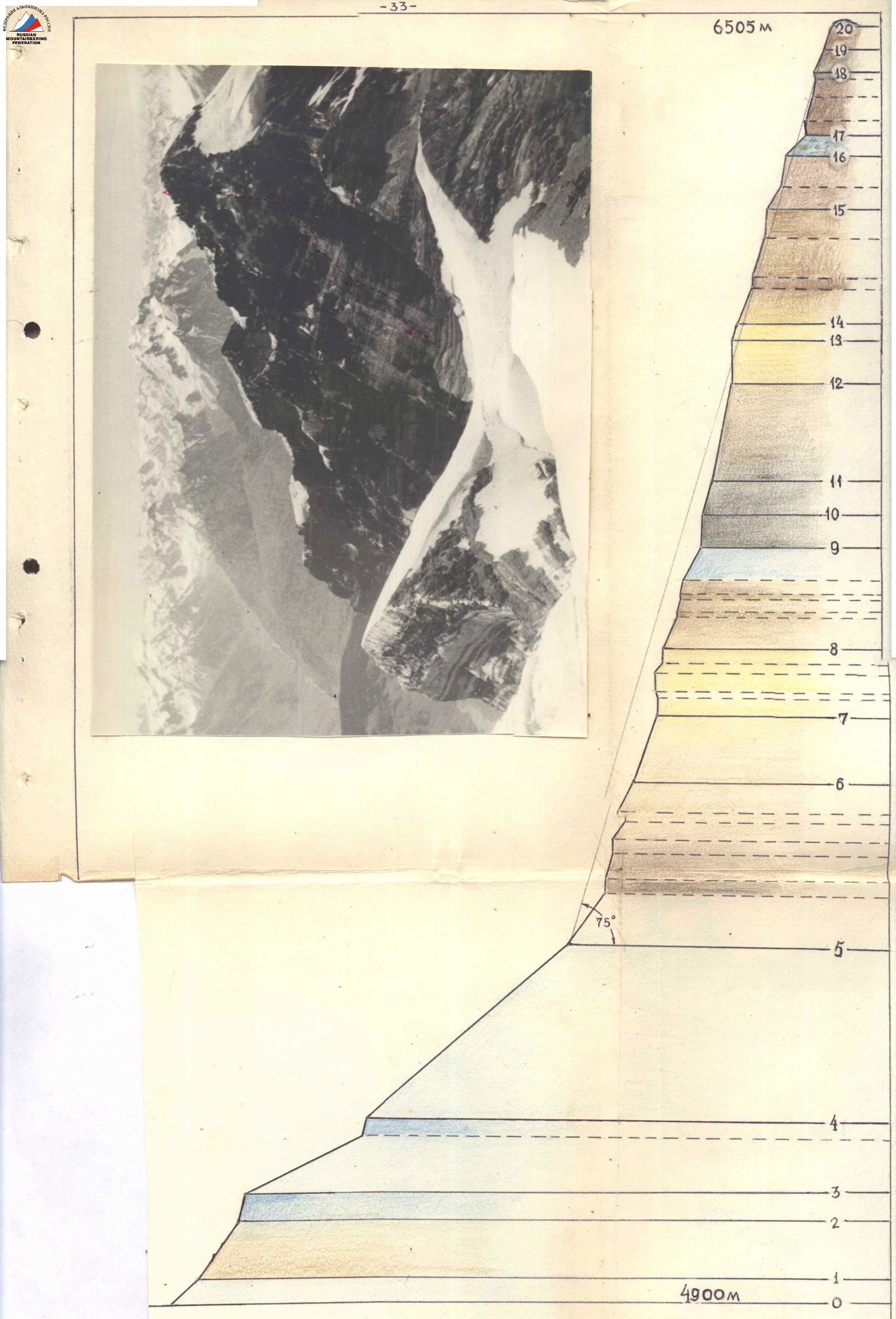
of the main characteristics of the ascent route. Ascent route — Peak Tajikistan via the northeast wall.
Height difference of the route 1550 m from the "cushion", 1880 m from the Bergschrund. Including the most complex sections — 400 m. Steepness of the route — 68° from the snow "cushion"; 62° from the Bergschrund.
| Dates of passage | Section | Average steepness | Length of section, m | Character of relief | Method of overcoming, protection | Weather conditions | Time of stop for bivouac | Time of departure | Hours taken | Number of rock pitons driven | Number of ice pitons driven | Overnight stay conditions | Note |
|---|---|---|---|---|---|---|---|---|---|---|---|---|---|
| July 30, 1968 | R0–R1 | 55° | 150 | Rocks, ice, snow | Free climbing, piton protection | Good | 17:00 | 7:00 | 10 h | 6 | 2 | Overnight stay on the Zuvand glacier, on snow | |
| R1–R2 | 65° | 70 | Ice wall | Step cutting. 2 ladders hung | 4 | ||||||||
| R2–R3 | 45° | 100 | Snow | Protection through ice axe | |||||||||
| R3–R4 | 45° | 100 | Snow, ice | ||||||||||
| R4–R5 | 50° | 40 | Ice | Step cutting | |||||||||
| R5–R6 | 35–40° | 200 | Snow | Protection through ice axe | |||||||||
| July 31 | R6–R7 | 45–50° | 80 | Snow-ice slope | Piton protection | Good | 16:00 | 8:00 | 8 h | 3 | Overnight stay on "cushion" on snow, good. Stayed here twice. | ||
| R7–R8 | 85° | 20 | Rock wall | Climbing with ladders (2 pcs.). Piton protection | 6 | ||||||||
| R8–R9 | 65° | 150 | Rock wall | Free climbing | |||||||||
| August 1 | R9–R10 | 60° | 100 | Slabs with ice and snow, "soft" sandy rock | Free climbing, 1 ladder in upper part | Good | 18:00 | 8:00 | 10 h | 7 | Semi-reclining overnight stay on a shelf. | ||
| R10–R11 | 75° | 40 | Narrow horizontal shelf | Free climbing | 3 | ||||||||
| R11–R12 | 90–100° | 20 | Vertical wall | Climbing with belay ledge and ladders | 10 | ||||||||
| R12–R13 | 75° | 7 | Fine-grained sandy rock | Free climbing, piton protection | 1 | ||||||||
| R13–R14 | 80–85° | 16 | Rock wall | Climbing with ladders (2 pcs.) | 4 | ||||||||
| R14–R15 | 60° | 65 | Friable rock concave wall, ending in a vertical inner corner | Free climbing | 3 | ||||||||
| R15–R16 | 75° | 40 | Rock wall | Free climbing | 5 | ||||||||
| R16–R17 | 50–55° | 60 | Ice slope with two rock walls (5–6 m) | Step cutting, piton protection | Good | 3 | 4 | ||||||
| R17–R18 | 85° | 10 | Sheer wall | Climbing with ladder (1 pc.) | 3 | ||||||||
| R18–R19 | 75° | 40 | Wall, narrow shelf in upper part | Free climbing, piton protection | 4 | ||||||||
| R19–R20 | 80° | 40 | Wall, narrow inner corner exiting onto a shelf | Free climbing, piton protection | 18:30 | 7:30 | 11 h | 5 | Sitting, very uncomfortable overnight stay on narrow shelves | ||||
| August 2 | R20–R21 | 75° | 35 | Rock wall | Free climbing, piton protection | 5 | |||||||
| R21–R22 | 50° | 25 | Ice-covered slabs | Step cutting, piton protection | Good | 1 | 2 | ||||||
| R22–R23 | 90–95° | 15 | Wall | Climbing with ladders (2 pcs.) | 5 | ||||||||
| R23–R24 | 60° | 110 | Snow-covered slabs | Free climbing | 7 | ||||||||
| R24–R25 | 65° | 60 | Snow-covered slabs | Free climbing | 3 | ||||||||
| R25–R26 | 75° | 80 | Smoothed rocks, mulda | Free climbing, piton protection | 8 | ||||||||
| R26–R27 | 80° | 65 | Rock wall | Climbing | 8 | Semi-reclining | |||||||
| August 3 | R27–R28 | 60° | 80 | Rock counterfort | Free climbing. Piton protection | Good | 17:30 | 7:30 | 10 h | 4 | Overnight stay on a shelf and "ridge" | ||
| R28–R29 | 65° | 100 | Snow-covered slab | Piton protection | Good | 7 | |||||||
| R29–R30 | 70° | 40 | Snow-covered slab | Piton protection | 4 | ||||||||
| R31–R32 | 70° | 40 | Snow-covered slab | Free climbing | 4 | ||||||||
| R32–R33 | 90° | 45 | Wall, натёчный ice | Climbing with ladders (3 pcs.) | 9 | ||||||||
| R33–R34 | 60° | 40 | Rock wall with snow-covered cracks | Free climbing. Piton protection | 3 | ||||||||
| R34–R35 | 85° | 12 | Wall | Climbing with ladder (1 pc.). Piton protection | 4 | ||||||||
| R35–R36 | 65° | 30 | Snow-covered slabs | Free climbing. Piton protection | 2 | ||||||||
| R36–R37 | 90° | 30 | Wall, inner corner in upper part | Free climbing. Piton protection | 6 | Made a good overnight stay on a narrow ridge | |||||||
| August 4, 1968 | R37–R38 | 45° | 65 | Snow slope | 17:00 | 8:00 | 9 h | 1 | |||||
| R38–R39 | 80° | 40 | Wall | Free climbing. Piton protection | Good | 5 | |||||||
| R39–R40 | 50° | 40 | Ice slope with rock outcrops | Free climbing. Piton protection | 3 | ||||||||
| R40–R41 | 90–95° | 15 | Overhanging wall | Climbing with ladders (3 pcs.). Piton protection | 7 | ||||||||
| R41–R42 | 75° | 35 | Wall | Free climbing | Weather began to deteriorate | 4 | |||||||
| R42–R43 | 75° | 50 | Wall | Piton protection | Wind, snow, visibility worsened | 4 | |||||||
| R43–R44 | 90–95° | 12 | Overhanging wall | Climbing with ladder (1 pc.) | 4 | ||||||||
| R44–R45 | 35° | 10 | Rock shelf | Free climbing. Piton protection | |||||||||
| R45–R46 | 70° | 40 | Rock counterfort | Free climbing | 3 | ||||||||
| R46–R47 | 70° | 60 | Friable wall | Free climbing. Piton protection | 3 | ||||||||
| August 5 | R47–R48 | 55° | 20 | Snow slope | 17:00 | 8:00 | 9 h | Good overnight stay on the summit |
Note:
Piton anchors (50 pcs. were taken) were not used for passing the route. They were used for organizing bivouacs. The weight of the daily food ration was chosen to be 750 grams per person, calculated for 12 days. The route with the approach and descent took 9.5 days. In total, 171 rock pitons and 17 ice pitons were driven in. 67 hours were spent on the route.
Team captain
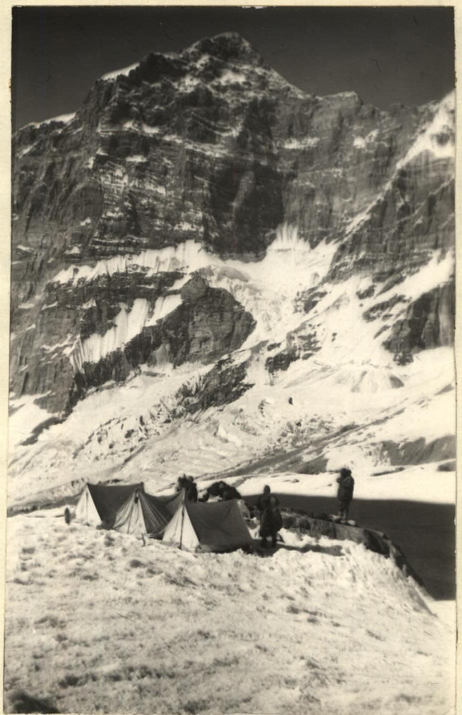
Boulder-bivouac on the Zuvand glacier
Comments
Sign in to leave a comment