Passport
I. Technical climbing category 2. South-West Pamir, Shakhdarin ridge (southern spur) 3. Pik Moskovskoy Pravdy, main summit 6075 m. 4. 6B (presumably) 5. Height difference 1300 m. 6. Length of sections 5 and 6 cat. diff. – 1020 m (5 – 690, 6 – 330) 7. Average steepness 71–72° 8. Pitons hammered: rock 142, ice 9, bolt 2, chocks 185; used for belays: rock 44, bolt 2, chocks 73. 9. Climbing hours — 49.5
- Overnight stays:
- 1 — on a platform laid out from stones and snow on an inclined slab;
- 2 — on a platform cut out in a snow-ice ridge;
- 3 — on a 1.5 m wide platform dug in a snowy slope;
- 4 — on a platform trampled on a snowy slope.
II. Team leader — Lebedikhin Aleksey Veniaminovich MS Team members: * Vinogradskiy Evgeniy Mihaylovich MS * Bryksin Valeriy Mihaylovich MS * Abramov Sergey Semenovich MS * Bazhukov Grigoriy Nikolaevich CMS * Chaschegorov Vitaliy Bronislavovich CMS
Coaches — Efimov S.B. HMS Lebedikhin A.V. MS
Approach to the route — July 30, 1982 Return — August 3, 1982
On the SW wall (variant via the right edge of the couloir)
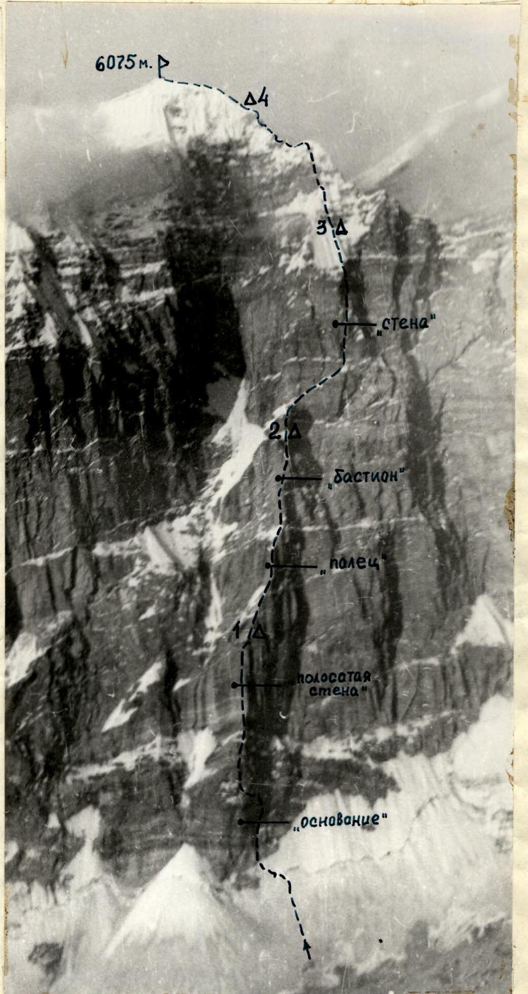 — Climbing route Δ
Overnight stays
— Climbing route Δ
Overnight stays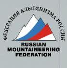
Reconnaissance and training climbs
During preparation for the championship, the team made an acclimatization climb to pass 5200 m, during which an initial overview of the wall was conducted.
Team members made training ascents:
- to Pik Babel 4B cat. diff.
- the full team climbed Pik Litva 5B cat. diff.
During these climbs, observation of the wall continued, and a series of photographs and sketches were made, allowing for an accurate representation of the wall's various sections, necessary for creating a realistic tactical plan. Additionally, another reconnaissance trip was made to the wall.
After this ten-day preparation, the following tactical plan was devised:
- day of approach — observation of the route and processing of ice and the internal angle of the "base" of the counterfort;
- first day — ascent to the first snowfield (under the "finger");
- second day — ascent to the "bastion";
- third day — ascent to the "wall";
- fourth day — ascent to the summit or overnight stay under the summit depending on snow conditions;
- fifth day — return to base camp;
- sixth day — reserve for bad weather.
The ascent showed that the tactical plan was correctly devised and, with intense daily work, was implemented with virtually no changes.
During the ascent, regular (twice a day) radio communication was maintained via "Vitalka" with an observation group on the opposite slope of the gorge.
Route description
The entire route can be conditionally divided into four parts:
- ascent to the "striped wall" (about 400 m). On this section, the path after the "base" on the "striped wall" is particularly complex;
- ascent to the "bastion" (about 400 m). On this section, overcoming the destroyed rocks of the "yellow belt" and overhanging sections of the "finger" and "bastion" was particularly problematic;
- ascent under the "roof" through the "wall". Very complex is the chimney after the traverse and the large cornice at the top of the wall;
- ascent to the North ridge via snowy and icy rocks.
On July 29, 1982, at 18:00, the rope team Lebedikhin — Chaschegorov began processing the route. Up a snowy slope through a bergschrund and then up ice to the right part of the "base" of the counterfort. Movement on front points of crampons with piton belays (R1, 70 m, 55°).
- Internal angle (R1, 40 m, 65°)
- Further up the right wall of this angle — a pendulum traverse to it; 20 m, 70° — via very small holds under a black cornice — 50 m, 75° (R2, 110 m, 70°).
Processing took 2.5 hours.
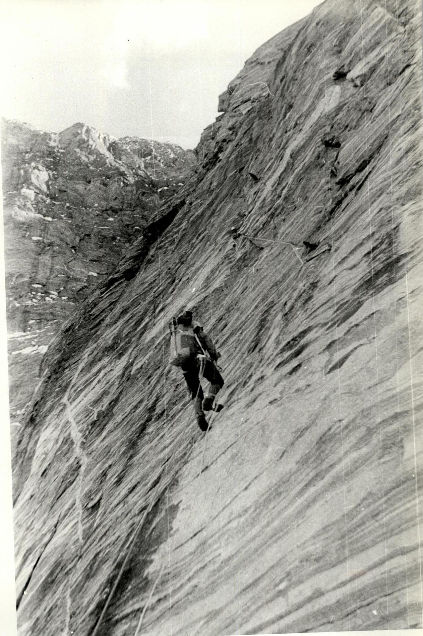
On July 30, at 9:00, the group started on the route. After traversing the perils, the rope team Lebedikhin — Chaschegorov bypassed the cornice on the right and began working left-up a chimney and severely destroyed steep rocks to a steep snow-covered ledge (R3, 70 m, 75°). Along the ledge left-up towards the center of the counterfort 20 m and then up 50 m (R4, 70°) via monolithic rocks to the shoulder of the counterfort. Straight up rocks of moderate difficulty (R5, 35 m, 60°) under the "striped wall".
V. Chaschegorov leads. Up monolithic rocks with small rare holds 25 m and pendulum left into an internal angle, up it (R6, 35 m, 80°). Further up the angle through an overhang for four meters onto a ledge and up an internal angle with an overhanging right part 20 m, of which 15 m with ladders and chocks (R7, 35 m). Up wide cracks in monolithic rocks (R8, 35 m, 70°). The slope eases. 20:00. Two ropes processed (80 m, 60°). Until 22:00, a platform was laid out on an inclined slab.
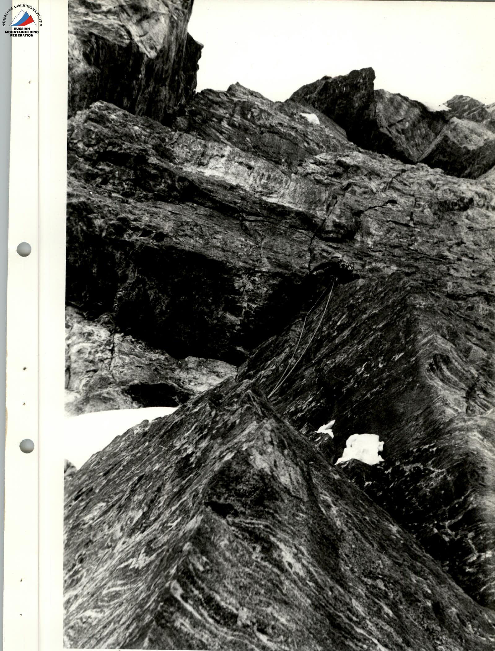
July 31. Start at 9:00. Up the fixed ropes towards the steep face of the "finger", another rope fixed to the wall. With fixed ropes, this is R9 (110 m, 60°). Up an internal angle on the left face of the "finger" with complex and extremely difficult climbing, using ladders and chocks (R10, 70 m, 80°). Exit onto a ridge with a snowy cap-cornice. Between the caps and up steep snow to the base of the bastion. Up internal angles with a pendulum traverse from the right to the left (15 m in ladders) under a cornice and, passing it on the left, again up an angle under a reddish overhang (R12, 70 m, 85–80°). Through a hanging reddish belt (8–10 m) vertically up on ladders — rocks very destroyed, pitons hold weakly (R13, 10 m, 95°), dangerous! Further up monolithic rocks (structure resembles tiles) up-right 20 m and up-left under an overhanging cornice and up an internal angle — monolithic rocks — extremely difficult climbing on small holds (R14, 90 m, 85–90°). 20 m up snowy rocks onto a snowy ridge. Stop for the night at 20:30. One and a half hours building a platform.
August 1. Start at 9:00. From the overnight position straight up a wall with small holds (a bolt hammered, ladders used for 5 m) and through a rock cornice up onto the bastion (R16, 50 m, 80°). Further up a snowy ridge with caps — cornices and a snowy bridge to the "wall" and traverse right (20 m) along a ledge under an overhanging wall (R17, 80 m, 30°). Right-up a small ledge and rocks with sections of snow and ice under large monolithic cornices to the base of a vertical chimney (R18, 100 m, 75–35°), at the end of the ledge above, possible rockfall from thawing snow and icicles!
Up the chimney — complex climbing (internal gaps filled with ice) through an overhang in the middle section with an exit to the right wall and further return to the chimney (R19, 40 m, 84°). Up rocks of blocky structure through an overhanging angle (ladders). For the first time on the route, old pitons were encountered, including one bolt.
Up through a system of internal angles via heavily snowy and icy rocks under a huge reddish cornice (R20, 110 m, 73°). Approach under the right part of the cornice up a wall with small holds. The cornice was overcome by A. Lebedikhin via a vertical crack through an overhanging rock (95°, 10 m — in ladders, 1 bolt, hammered) — the previous team passed the cornice on the left.
After the overhang, left along a small ledge to the base of a chimney (R21, 35 m, 95°). On R21, 4 rucksacks were pulled up.
Up a vertical chimney to the top of the "wall" (where the chimney is filled with ice, ladders used), climbing is complex. Exit to the lower edge of a snowy slope (2 old bolt pitons, R22, 40 m, 85°). Up a snowy slope of almost constant steepness, equal to 45–50°, at times sinking in loose snow to the hips, exit to upper rocks (R23, 110 m, 50°).
The snowy ascent was made late in the evening, when the slope had already frozen (from 21:30 to 23:00). Overnight stay on a snowy slope, 20 m below the upper rocks with belays from chocks and pitons on the rocks. A 1.5 m wide platform was dug in loose snow.
August 2. Start at 8:00.
- Up rocks with sections of ice (R24, 20 m, 70°) and further 30 m up ice with a steepness of 55° to a snowy ridge (R25, 30 m, 55°).
- Left under a snowy cornice 20 m and further up 40 m up a snowy rock wall onto the North ridge (R26, 40 m, 70°).
- Up the North ridge through two steep rock "gendarmeres" (R28 and R30) to the summit slope.
The snow was soft. Overnight stay under an overhanging rock on a snowy platform. Stop at 18:00.
August 3. Start at 8:20. Up a snowy slope frozen overnight, reached the summit at 8:50. Descent through the south summit to base camp took 7.5 hours.
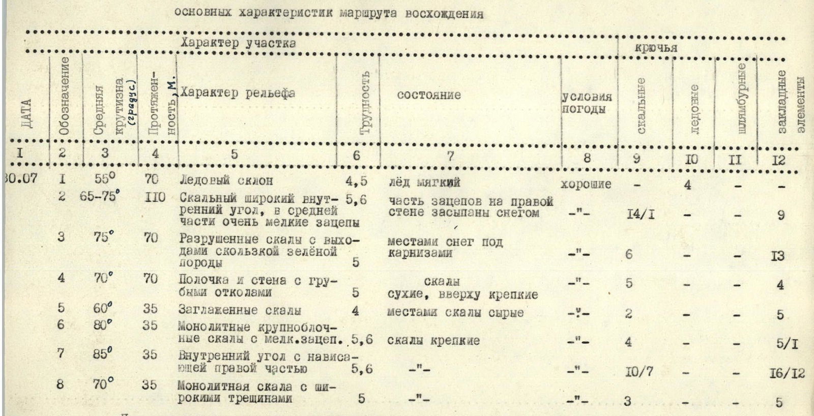
Table
Main characteristics of the ascent route
| Date | Designation | Average steepness (degree) | Length, m. | Character of section (Relief character) | Difficulty | State | Weather conditions | Rock pitons | Ice pitons | Bolt pitons | Chock elements |
|---|---|---|---|---|---|---|---|---|---|---|---|
| 30.07 | R1 | 55° | 70 | Ice slope | 4,5 | soft ice | good | 4 | - | - | - |
| R2 | 65–75° | 110 | Rock wide internal angle, in middle section very small holds | 5,6 | part of holds on right wall covered with snow | -"- | 14/1 | - | - | 9 | |
| R3 | 75° | 70 | Destroyed rocks with outcrops of slippery green rock | 5 | snow under cornices | -"- | 6 | - | - | 13 | |
| R4 | 70° | 70 | Ledge and wall with coarse splits | 5 | dry, upper part firm | -"- | 5 | - | - | 4 | |
| R5 | 60° | 35 | Polished rocks | 4 | rocks partly wet | -"- | 2 | - | - | 5 | |
| R6 | 80° | 35 | Monolithic large-block rocks with small holds | 5,6 | rocks firm | -"- | 4 | - | - | 5/1 | |
| R7 | 85° | 35 | Internal angle with overhanging right part | 5,6 | -"- | -"- | 10/7 | - | - | 16/12 | |
| R8 | 70° | 35 | Monolithic rock with wide cracks | 5 | -"- | -"- | 3 | - | - | 5 |
Preliminary processing on July 29 of sections R1, R2 for 2.5 hours. Start of work on the route 9:00. End — 20:00 with processing 2/3 of R9. Climbing hours — 11. Height difference about 400 m. Overnight stay on a platform laid out after 2 hours of work on an inclined slab.
| Date | Designation | Average steepness (degree) | Length, m. | Character of section (Relief character) | Difficulty | State | Weather conditions | Rock pitons | Ice pitons | Bolt pitons | Chock elements |
|---|---|---|---|---|---|---|---|---|---|---|---|
| 31.07 | R9 | 60° | 110 | "Ram's foreheads" and slabs with leftward inclination | 3,4 | snow, wet rocks | Good | 6 | - | - | 6 |
| R10 | 80° | 70 | Internal angle, holds small | 5,6 | rocks firm | -"- | 7/4 | - | - | 18/13 | |
| R11 | 50° | 30 | Snowy cornices on ridge, rock outcrops | 3 | firm snow with ice axes | -"- | 2 | - | - | - | |
| R12 | 80–85° | 70 | Monolithic internal angles with cornice | 5,6 | rocks firm, part of cracks filled with dirt | -"- | 9/5 | - | - | 15/11 | |
| R13 | 95° | 10 | Hanging reddish rock belt | 6 | Decaying rocks crumbling into sand | -"- | 8/8 | - | - | 2/2 | |
| R14 | 85–90° | 90 | 30 m monolithic rocks with small lateral holds. Wide internal angle | 5,6 | rocks firm, upper part partly wet | -"- | 7/1 | - | - | 15/2 | |
| R15 | 60° | 20 | Snowy rocks | 4 | snow with ice axes | -"- | 2 | - | - | 1 | |
| 01.08 | R16 | 80° | 50 | Wall with small holds | 5,6 | dry, flakes weakly attached to rock | good | 8/5 | - | 1/1 | 6/4 |
| R17 | 30° | 80 | Snowy ridge with cornices and bridge. Rocky ledge | 4,5 | firm snow, ledge partly snowy | -"- | 3 | - | - | - | |
| R18 | 75–35° | 100 | Inclined (35°) small ledge on 75° wall | 4,5 | rocks snowy and in right part icy | -"- | 6 | - | - | 2 | |
| R19 | 84° | 40 | Vertical chimney | 5,6 | monolithic rocks, ice in gaps | -"- | 5/2 | - | - | 6/1 | |
| R20 | 73° | 110 | System of internal angles, rocks large-block | 5 | on horizontal ledges, frozen snow, ice | -"- | 7/3 | - | - | 11/6 | |
| R21 | 95° | 35 | Cornice and overhanging wall | 6 | rocks, wall partly unstable | -"- | 8/5 | - | 1/1 | 17/14 | |
| R22 | 85° | 40 | Chimney with overhanging sections | 5,6 | ice inside chimney | -"- | 4 | - | - | 9/6 |
Start of work 9:00, end at 20:30 with processing 0.5 R16. Climbing hours 11.5. Height difference — 350 m. Overnight stay on a platform cut out in 1.5 hours in a snow-ice ridge adjacent to the wall.

| Date | Designation | Average steepness (degree) | Length, m. | Character of section (Relief character) | Difficulty | State | Weather conditions | Rock pitons | Ice pitons | Bolt pitons | Chock elements |
|---|---|---|---|---|---|---|---|---|---|---|---|
| 02.08 | R23 | 50° | 110 | Snowy slope | 4 | Loose snow under thin crust | -"- | - | - | - | - |
| R24 | 70° | 20 | Rocks with ice sections | 5 | rocks firm | good | 5 | 1 | - | 2 | |
| R25 | 55° | 30 | Ice slope (gutter) | 5 | ice thawing from top | -"- | - | 4 | - | - | |
| R26 | 70° | 40 | Rocky wall | 5 | water flowing, ice in cracks | -"- | 4 | - | - | 3 | |
| R27 | 40° | 80 | Snowy ridge | 2 | snow with ice axes | -"- | - | - | - | - | |
| R28 | 70° | 40 | Rocky "gendarme" on ridge | 5 | snow on rocks | -"- | 3/1 | - | - | 5 | |
| R29 | 45° | 50 | Snowy ridge | 2 | snow with ice axes | -"- | - | - | - | - | |
| R30 | 75–80° | 30 | Rocky "gendarme" with overhanging middle part | 5 | rock partly covered with ice | -"- | 4/2 | - | - | 3/1 |
Start of work 8:00, end 18:00. Climbing hours 10. Overnight stay on a platform trampled on a snowy slope under an overhanging rock.

| Date | Designation | Average steepness (degree) | Length, m. | Character of section (Relief character) | Difficulty | State | Weather conditions | Rock pitons | Ice pitons | Bolt pitons | Chock elements |
|---|---|---|---|---|---|---|---|---|---|---|---|
| 03.08 | R31 | 25–40° | Snowy slope, leftward to cornices. Frozen snow | good | - | - | - | - |
Summit reached at 8:50. Climbing hours 0.5.
Total climbing hours — 49.5; number of rock pitons — 142 (of which 44 for belays); number of bolt pitons — 2 (both for belays); number of chock elements — 185 (73 for belays); number of ice pitons — 9; average steepness of the wall (rock) section of the route 71–72°. Height difference of the route — 1300 m. Length of the route (without traverses) — 1470 m.
 Sec.6
Sec.6
 Sec.21