ASCENT DOCUMENT
I. Ascent classification: High-altitude technical. 2. Ascent area: Pamir. Shakhdarin Range. 3. Peak Moskovskaya Pravda Main via North-Eastern wall (V. Solonnikov's route) 4. Difficulty category: 6 5. Route characteristics: Route length — 1480 m Height difference: wall — 1200 m, to the summit — 1300 m. Average steepness — 82°, complex sections — 85°. Section lengths:
- 4th diff. cat. — 70 m
- 5th diff. cat. — 220 m
- 5th diff. cat. — 410 m
- 6th diff. cat. — 780 m
- Pitons driven:
| for belay | for creating ITO | |
|---|---|---|
| Rock | 308 | 164 |
| Bolt | — | 3 |
| Ice | — | — |
- Total climbing hours: 93
- Number of bivouacs: 10 (all tent, semi-reclined and reclined)
- Team leader: Pilipenko Vladislav Sergeevich, Candidate Master of Sports
Team members:
- Grigorenko-Prigoda Yuri Ivanovich, Master of Sports
- Kalashnikov Evgeny Fedorovich, Master of Sports
- Ovcharenko Valery Davidovich, Candidate Master of Sports
- Babitsky Alexander Vladimirovich, Candidate Master of Sports
- Volkov Leonid Borisovich, Candidate Master of Sports
- Team coach: Grigorenko-Prigoda Yu.I., Master of Sports of the USSR, senior instructor.
II. Date of departure on the route: June 26, 1979
Date of return: July 6, 1979
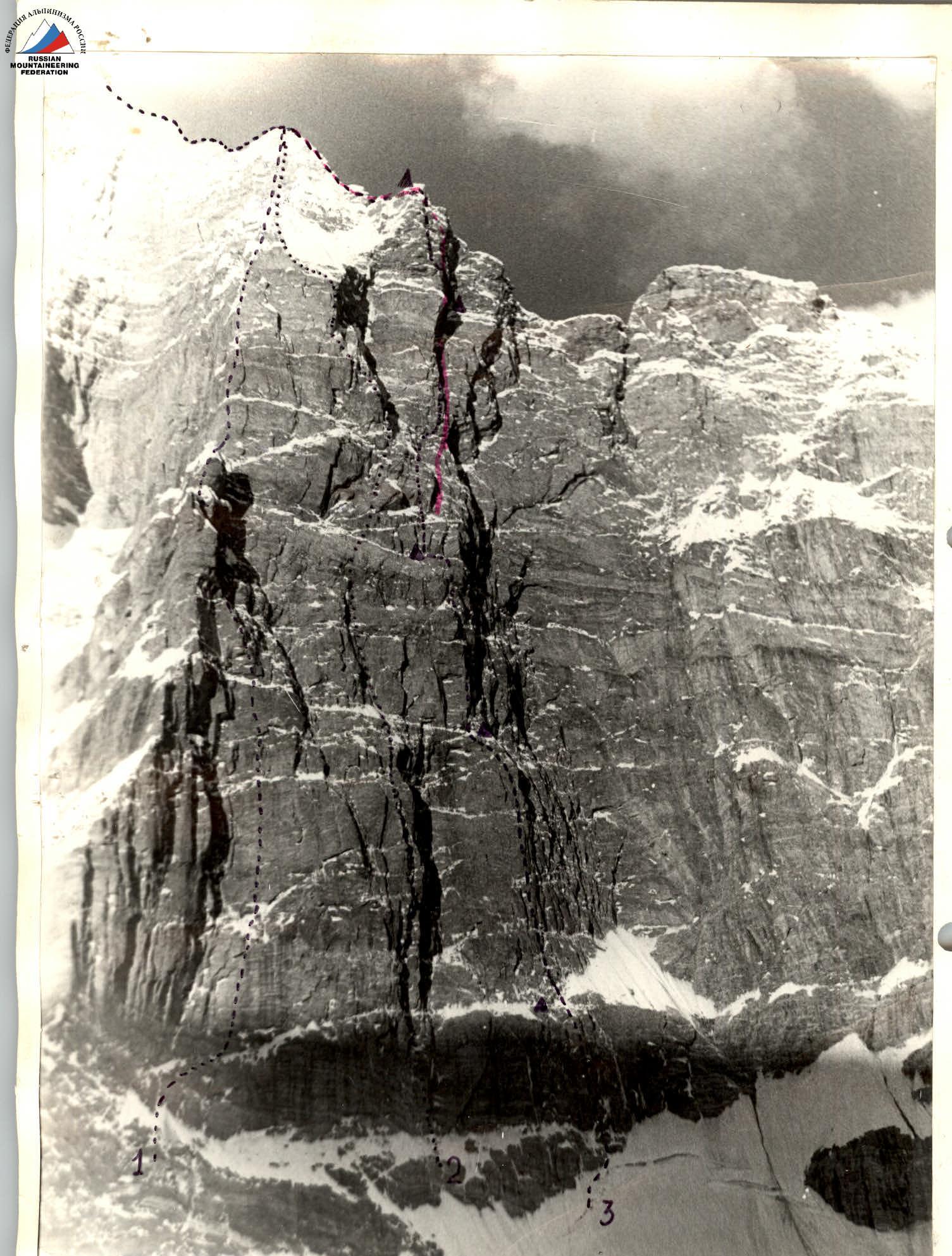
| № | Route | Author | Year | Description |
|---|---|---|---|---|
| 1 | Route | O. Kapitanova | 1978 | ССВст |
| 2 | Route | A. Skesareva | 1963 | у.СВ.Ст |
| 3 | Route | V. Solonnikov | 1977 | пр.ч. СВ ст. |
| Bershov | 1978 | л.баст. СВст. | ||
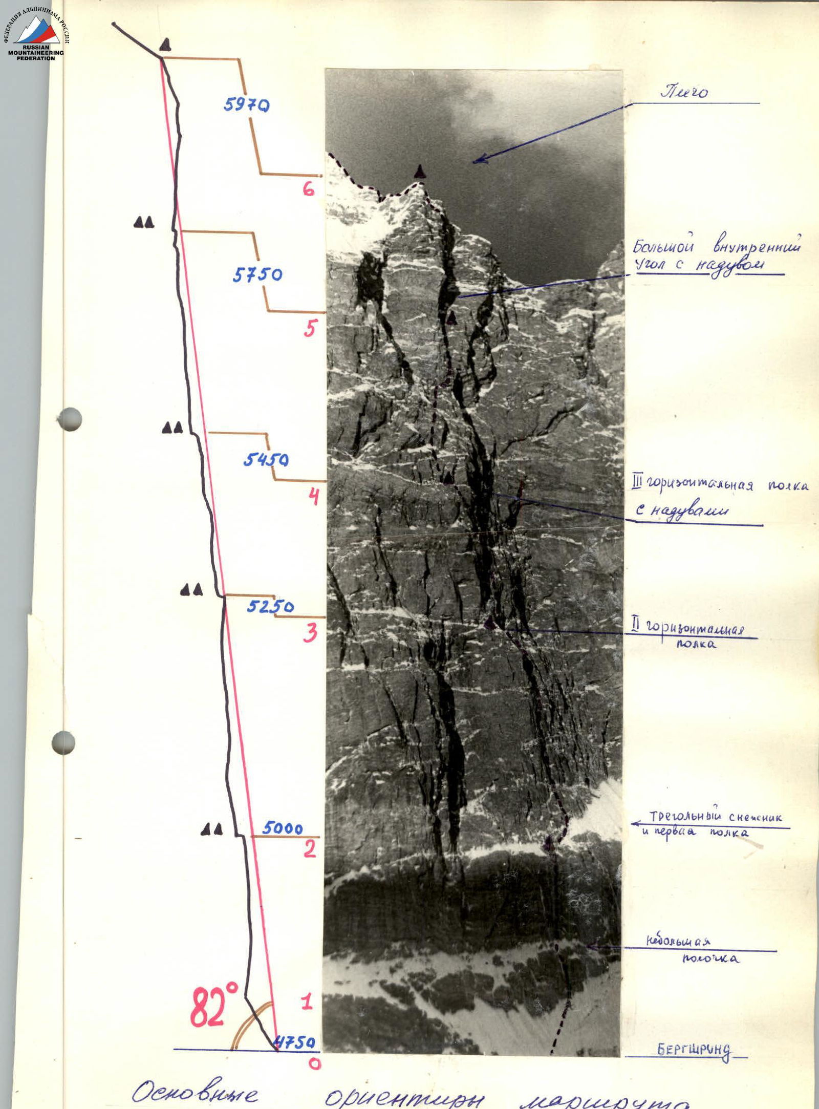 |
Main landmarks of the route
- Shoulder
- Large internal angle with a snowdrift
- III horizontal ledge with snowdrifts
- II horizontal ledge
- Triangular snowfield and first ledge
- Small ledge
- Bergschrund
Section characteristics
| Date | Section designation | Average steepness | Length | Terrain characteristics | Difficulty | Condition | Weather conditions | Rock | Bolt |
|---|---|---|---|---|---|---|---|---|---|
| June 25 | — | — | — | Processing snow-ice slope leading to the start of the route (4 hours). | |||||
| June 26 | R0–R1 | 60° | 60 m | Snow-ice slope | 4 | — | Good | — | — |
| R1–R2 | 80° | 205 m | Rock wall | 5 | Icy | Good | 58 | — | |
| — | — | — | Departure at 8:00. Stop for bivouac at 16:00. Processing further path 2 hours. Total 10 hours. | ||||||
| June 27 | — | — | — | Processing wall 6 hours. | |||||
| June 28 | R2–R3 | 78° | 250 m | Internal corners, chimneys | 5–6 | Icy | Good | 85 | — |
| — | — | — | Processing further path — 7 hours. Departure from bivouac at 9:00, stop for bivouac at 18:00. | ||||||
| June 29 | — | — | — | Processing further path — 7 hours. | |||||
| June 30 | R3–R4 | 84° | 195 m | Slabs, cornices, walls | 6 | Icy | Snow, fog | 88 | — |
| — | — | — | Departure on route at 9:00. Stop for bivouac at 19:00. Total 10 hours. | ||||||
| July 1 | — | — | — | Processing further path — 8 hours. | |||||
| July 2 | R4–R5 | 83° | 315 m | Slabs, internal corners | 5–6 | Icy | Fog | 101 | — |
| — | — | — | Departure from bivouac at 8:30, stop at 19:00. Total 10 hours 30 minutes. | ||||||
| July 3 | — | — | — | Processing overhanging corner (hours) | |||||
| July 4 | R5–R6 | 87° | 245 m | Internal corner | 6 | Loose snow | Good | 107 | 3 |
| — | — | — | Departure from bivouac at 8:00, stop for bivouac at 18:00 (10 hours). | ||||||
| July 5 | R6–R7 | — | — | Ascends, ridges | 5 | Loose snow | Good | 24 | — |
| — | — | — | Departure on route at 8:00, stop at 20:00. |
Explanation for the table
R0–R1 (60 m, 4th diff. cat.)
Along steep snow, bypassing the overhanging wall of the bergschrund, approach to the rocks of the Central wall. Traverse right-up 20 m along the rocks. The landmark for the exit to the wall is a steep chimney under the left edge of the "triangular snowfield".
R1–R2 (205 m, 5th diff. cat.)
Up the wall of black broken rocks to the entrance to the chimney (15 m). Through the chimney 50 m of complex climbing ( местами натёчный лёд) to the exit onto a small ledge. Further along icy rocks (slabs with vertical fissures) 30 m of climbing lead to a wide internal corner (ice, "live rocks"). Vertically up the internal corner (70 m), bypassing overhanging sections to the right, approach under a 40-meter wall of steep snow-covered rocks. Through the wall, exit to the "triangular snowfield". From its left edge, a narrow ledge starts, horizontally crossing the wall. A bivouac is set up on it (The ledge is maximally widened with hammers and ice axes, two tents are hung). I control point.
R2–R3 (250 m, 5–6 diff. cat.)
Further movement is along the system of steep internal corners and chimneys starting above the "triangular snowfield" and leading to the second horizontal ledge. From the bivouac, right-up 20 m first along simple snow-covered rocks, then 70 m along monolithic steep slabs (climbing is complex). Entrance to a steep internal corner. Up the corner 45 m, then traverse up-right 10 m. A series of higher-lying cornices of the wall are overcome along a 75-meter, местами нависающий internal corner. Climbing is very difficult, ITO. Icy wall (20 m) leads to a flattening section. Along a steep snow-ice ridge 10 m, approach to the second horizontal ledge. Traverse along it 30 m to the left. II control point. Bivouac. A site for one tent is cut out in a steep snow-ice drift, the second tent is hung on a narrow (0.6 m) ledge.
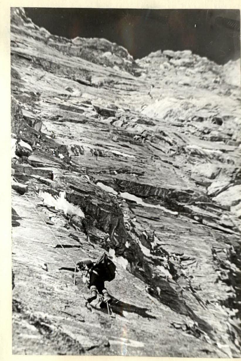
R3–R4 (195 m, 6 diff. cat.)
Further, the route becomes more complex (passing the "Ryzhy пояс" - "Red belt"). From the snowdrift, right-up along the internal corner and further along the icy fissure (50 m), then a 20-meter wall with a small number of holds leads to a slab (70 m) composed of fragile rocks like conglomerates. Climbing is difficult. The slab leads to a narrow ledge under overhanging rocks.
A massive overhanging section is passed by extremely difficult climbing (50 m) (small number of holds, ITO) and through a small yellow cornice, exit to the third horizontal ledge. Difficult traverse to the left along a narrow, местами исчезающей and overlapped by drifts ledge (45 m). At the point where the ledge widens to 60–70 cm — bivouac. III control point.
R4–R5 (315 m, 5–6 diff. cat.)
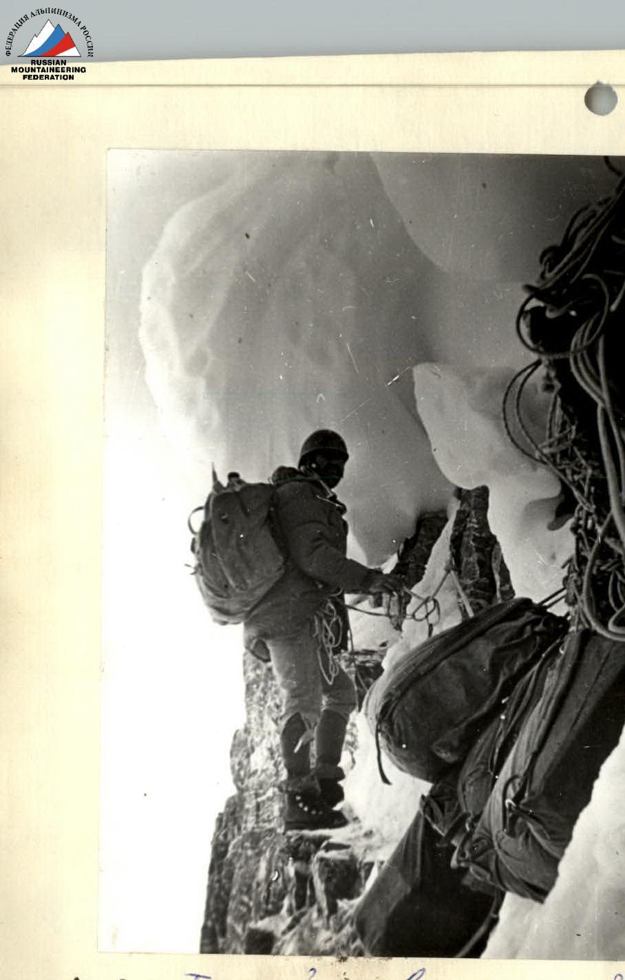
Further movement along the "Ryzhy пояс" and approach to the "Big angle". Left of the bivouac, straight up along slab-like smoothed rocks ( местами натёчный лёд) 30 m to an internal corner with натёчный лёд. Along the corner (20 m), then 50 m along a slab, approach under an overhanging internal corner. Overcoming the corner (10 m) and a 20-meter monolithic slab, we come to the third, 20-meter internal corner. Along it, exit to a flattening section up to 60° (broken rocks, snow-ice ridge leading to an inclined ledge). Along the ledge to the right to a bastion protruding from the wall (40 m) and along the left edge of the bastion (smoothed steep wall — 40 m) to a small ledge. Exit to the "Big internal angle". From the ledge, along the right side of the "angle" another 40 m to the second ledge. Complex climbing, ITO. The "internal angle" retains massive glaciation in places. From the ledge, the "Big drift" is visible — a snow pillow overlapping the "angle". Along the internal corner 50 m (steep, rocks frozen in ice) exit to the "Big drift" and further — onto the drift. Snow site 8 × 2.5 m. Bivouac. 4 control point in a can on a piton.
R5–R6 (250 m, 6 diff. cat.)
The most complex section of the route. For 80–100 m, the walls forming the "internal angle" here overhang up to 90–100°. Minimal number of holds, местами their absence. "Live" рыжие нашлёпки are encountered. Climbing is extremely difficult, местами artificial. All, except the first, pass the section on a free-hanging rope. Three bolt pitons are driven. Pulling rucksacks. From the bivouac, exit to the right wall of the "angle". 40 m of climbing to a ledge. Further up, bypassing a significant overhang of the left wall of the "angle" to рыжие overhanging cornices, which are overcome "head-on" just 60–70 m from the ledge. Exit to a flattening (75–70°). Broken, местами заснеженные rocks. After 40 m — a ledge for 3–4 people. Another 30 m of quite difficult climbing leads to a ledge — a block wedged in an internal corner. From here up and further along the rocks to the left 5–4 diff. cat., exit to a long (20 m) snow-covered ledge.
R6–R7 (5 diff. cat.)
Above, pre-ridge, heavily snow-covered sections are visible. Snow is loose, crumbly, often in the form of significant drifts. Difficult exit to the snow-covered ridge (40 m) and further another 20 m to a gentle shoulder. Site for two tents. 5 control point. Bivouac. Further movement along the ridge. Overcoming two ascends of the ridge of 100–120 m (on average 5 diff. cat.), местами затруднительное passage — drifts and cornices of loose frosty snow, broken rocks. Exit to the summit and descent along a wide, technically simple ridge towards the South peak. Under it, bivouac. To the South peak and further down along the ridge 2 diff. cat.
Ascent diary
| Date | Description |
|---|---|
| June 20, 21 | Organization of a storm camp. Observation of the route. |
| June 25 | Approach. Processing the start of the route (4 hours). |
| June 26 | Departure on the route at 8:00. Passage of sections R0–R1, R1–R2. Stop for bivouac left of the "triangular snowfield" at 16:00. |
| June 27 | Processing further path. In 7 hours 30 minutes, 210 m of rope is fixed. |
| June 28 | Departure on the route at 9:00. Passage of section R2–R3. Stop for bivouac at 18:00. |
| June 29 | Processing section R3–R4 (8 hours). 195 m of rope is fixed. Weather deterioration. Snowfall, wind, fog. |
| June 30 | Passage of section R3–R4. Departure on the route at 9:00. Stop for bivouac at 19:00. Fog, visibility 40 m. |
| July 1 | At night, thunderstorm, wind, heavy snowfall. Processing the route. In 8 hours, 190 m of rope is fixed. |
| July 2 | Passage of section R4–R5. Departure at 8:30. Stop for bivouac at 19:00. Bivouac on the "Big drift". |
| July 3 | Processing the route. In 7 hours, 100 m of rope is fixed. |
| July 4 | Passage of section R5–R6. Departure on the route at 8:00. Stop for bivouac on the "shoulder" at 18:00. |
| July 5 | Departure on the route at 9:00. Passage of section R6–R7. Exit to the summit at 20:00. Descent along the ridge to the South peak. Bivouac. |
| July 6 | Descent to the base camp. |
 |
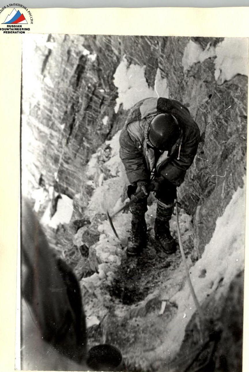
Section R3–R4. "Difficult traverse along a narrow, местами исчезающей and overlapped by drifts ledge". III control point.
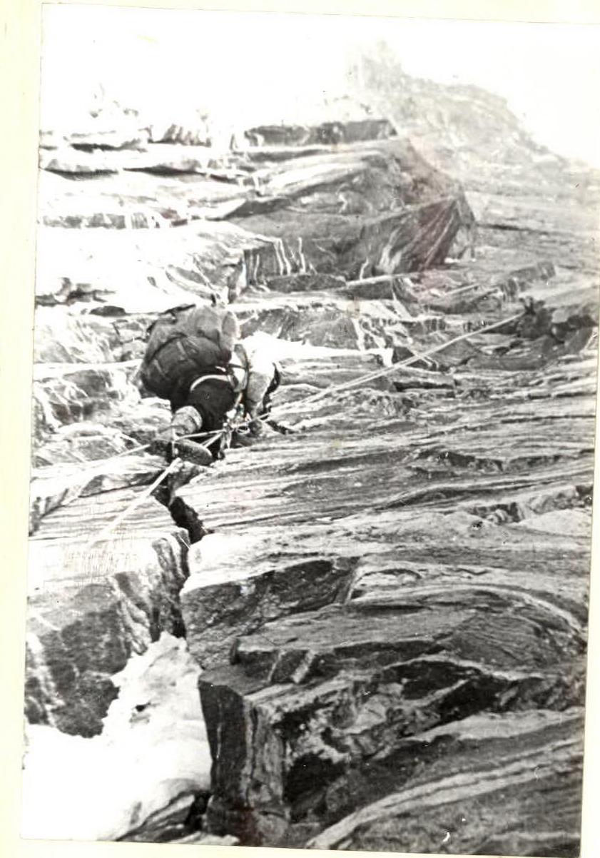
Section R4–R5. "Then along a steep 50-meter slab, approach under an overhanging internal corner".
Preparing the site. III control point.
Section R4–R5. "Approach to the third, 20-meter internal corner".
Togsono... (Image text is untranslated as it appears to be nonsensical or in a different language/script that doesn't require translation according to the guidelines)