ASCENT DOCUMENT
- ASCENT CLASS: HIGH-ALTITUDE TECHNICAL
- ASCENT AREA, RANGE: SW PAMIR, SHAKHDARINSKY RANGE
- PEAK, ITS HEIGHT, ASCENT ROUTE: P. MOSKOVSKAYA PRAVDA, 6075 m. VIA NE WALL, LEFT BASTION,
- ANTICIPATED DIFFICULTY CATEGORY: 6
- ROUTE CHARACTERISTICS: ELEVATION GAIN: 1400 m SECTION LENGTH: 5/6 km approx. 11–400 m, 11–220 m, IV–200 m, V–540 m, VI–700 m AVERAGE STEEPNESS: 70–75°
- PITONS PLACED:
FOR ARTIFICIAL SUPPORT:
- ROCK PITONS: 3
- NUT PLACEMENTS: 100
- ICE SCREWS: 108
- BOLTS: 36
- TOTAL CLIMBING TIME: 61 hours
- NUMBER OF NIGHTS SPENT: 5
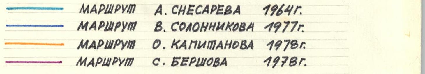
- SURNAME, FIRST NAME, PATRONYMIC OF LEADER AND PARTICIPANTS: BERSHOV SERGEY IGOREVICH, Master of Sports BAKHTIGOZIN VITALIY ANATOL'EVICH, Master of Sports GRIGORENKO-PRIGODA YURY IVANOVICH, Master of Sports TOLSTOUSOV ALEKSANDR NIKOLAEVICH, Candidate Master of Sports
- TEAM COACH: SPESIVTSEV A.E., Master of Sports
- DATE OF DEPARTURE AND RETURN: August 8 – August 13, 1978
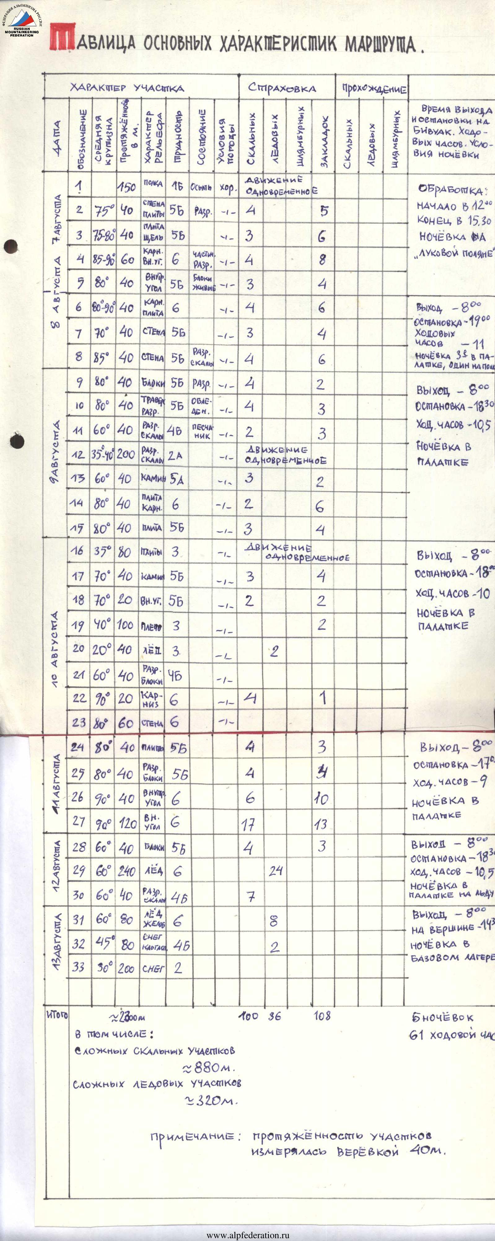
Total length: ~2300 m. Including:
- complex rock sections: ~880 m.
- complex ice sections: ~320 m. Number of nights spent: 5. Total climbing time: 61 hours.
Note: section lengths were measured with a 40 m rope.
Analysis of Main Route Characteristics
Explanations for the Table
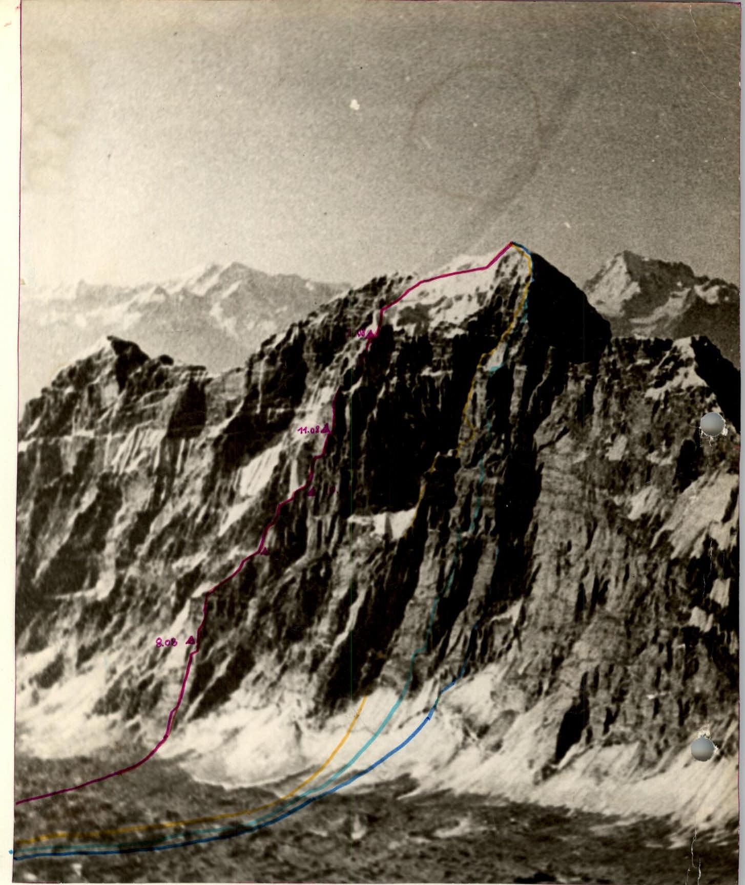
 Peak Moskovskaya Pravda is located in the Shakhdarinsky Range of the Southwestern Pamir. Follow the Kishly-Dzherob valley to the " лукавая поляна" ( лукавая glade). From the glade, cross the glacier to the base of the left bastion of the northeast wall of Moskovskaya Pravda. The bastion cuts through the northeast wall from the glacier to the summit. The route starts along a talus shelf in the left part of the bastion. Traverse this shelf from left to right for approximately 150 m. The route follows a weakly expressed counterfort of the bastion.
- The first 40 m are on slabby terrain, free climbing.
- The next 40 m start with a 10 m overhanging crack. Climbed free on "otryv" (on tension).
- Then 20 m of slab with a crack, ending in a 10 m internal corner. Protection is via pitons and nuts. To facilitate free rope movement, use nylon tape slings.
- The next section - slab and cornice - is climbed free for 20 m to a ledge.
- Another 20 m on slabs to an internal corner with blocks.
- The internal corner ends in an overhang, followed by a ledge. All climbed free in rock shoes.
- Traverse the ledge right and up for 40 m on freestanding blocks.
- Then 10 m under a cornice (caution: loose blocks).
- Under the cornice, a nut was placed and two pitons were driven for artificial aid.
- The cornice is climbed on its left side, free climbing on a flake.
- Then another 20 m on a steep slab with a crack.
- The path then goes along a ledge left for approximately 30 m. Here, a bivouac can be set up: three in a tent, one on a nearby ledge.
- Continue diagonally right-up for 40 m on steep slabs.
- Then right-up - difficult climbing on shattered rock under a cornice.
- The cornice is bypassed on the right, then on shattered rock of an internal corner for 40 m to the next cornice.
- From here, 40 m left-up on icy shattered rock to a ledge.
- From the ledge up, 40 m on rock resembling "sandstone" - exit onto the counterfort.
- Movement along the counterfort is simultaneous for approximately 200 m on shattered rock to a 40 m ascent - a crack transitioning into a chimney.
The next 80 m are a steep slab with a crack and cornice in the middle. Climbed free. Protection via pitons and nuts. Bivouac under this wall - in a tent.
After the wall - approximately 80 m of slabs. Simultaneous movement.
Then a 40 m ascent - chimney and 20 m internal corner. Protection via pitons and nuts.
Then 100 m of shoulder, approximately 40° steep. One place has a 20 m ascent - internal corner.
Next, 40 m of ice ridge. Protection via ice screws. Climbing in crampons.
The next section - 40 m of shattered rock leading to the upper bastion. A bivouac site was set up here in a tent.
From the bivouac:
- The first 20 m of the bastion are very steep rock with cornices and few holds.
- Then 60 m of internal corner consisting of steep shattered rock. Protection via pitons and nuts.
Exit onto a ledge. From the ledge, 40 m on slabs right. Then 40 m of steep shattered rock lead into an internal corner with blocks.
Continue up a steep internal corner for 40 m to a flake (loose blocks). Bivouac here in a tent.
From the flake, 120 m of internal corner filled with ice. Rock is solid, steep, and partly overhanging. Some sections of the corner are climbed "on otryv". Protection via pitons and nuts.
After passing the upper bastion, the path goes:
- Right-up on icy rock - 40 m.
- Then movement diagonally right-up on steep ice on the front points of crampons (12-tooth) with a special ice hammer and ice axe - 40 m. Protection via pitons, through titanium ice screws.
- Then another 200 m of similar ice towards an ice "rooster" at the top on the ridge.
At the end of the sixth rope length of ice - bivouac on the ice ridge.
From the bivouac:
- Right-up on ice to an outcrop of shattered rock - 40 m.
- On rock, 40 m right-up. Protection via pitons and nuts.
- Then another 80 m of steep ice and exit onto a rocky ridge with calga spurs.
Along the ridge, transitioning into a hanging glacier, we reach the main pre-summit ridge, 50 m from the peak Moskovskaya Pravda. Upon reaching the main ridge, an ice cornice was chopped through.
Descent from the summit along the ridge via the peak Yuzhnaya Moskovskaya Pravda to the base camp on the Kishly-Dzherob glade - 16 hours.
