
Ascent Passport
- Ascent class — high-altitude technical.
- Ascent area, ridge — South-West Pamir, Shakhdarin.
- Peak, its height, route — Pik Luknitskogo, 5800 m, ascent via the North face.
- Proposed difficulty category — 6B.
- Route characteristics: height difference — 1600 m, average steepness — 70°, length of sections with 5–6 difficulty category — 1040 m.
- Pitons driven: for belaying for creating ITO rock 140 pcs., ice 3 pcs., bolted — —
- Number of climbing hours — 30.
- Number of bivouacs, their characteristics — 2 bivouacs, of which: 1 seated.
- Surname, name, patronymic of the leader, participants, and their qualification: Golubenko Mikhail Nikolaevich CMS Grishchenko Viktor Ivanovich CMS Chub Grigory Ivanovich CMS Kiyanitsa Nikolai Nikolaevich CMS Grishchenko Valentin Anatolyevich CMS Slavinsky Pavel Frantsevich CMS.
- Team coach — KENSITSKY L.V.
- Date of departure on the route and return — July 21, 1978 – July 24, 1978.
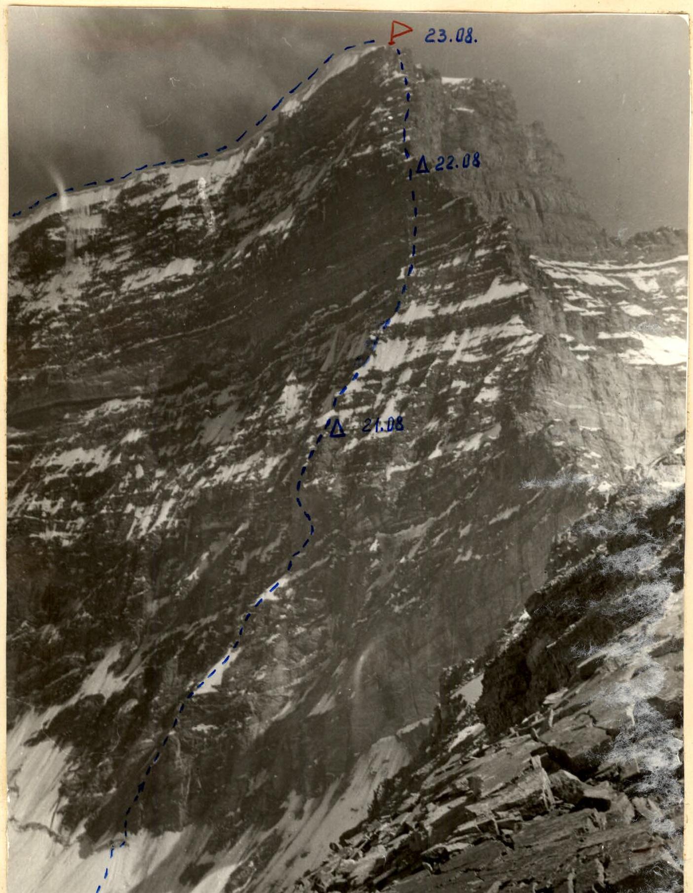
Table of main characteristics of the ascent route
| Date | Designation | Average steepness in degrees | Length in m | Character of relief | Difficulty | Condition | Weather conditions | Pitons (rock/ice) | Pitons (bolted) |
|---|---|---|---|---|---|---|---|---|---|
| 1 | 2 | 3 | 4 | 5 | 6 | 7 | 8 | 9 | 10 |
| 21.07. | R0–R1 | 80 | 60 | oblique slab, inner corner | 5 | Destroyed | clear | 11/0 | - |
| R1–R2 | 60 | 80 | couloir with ice | 4 | Icy, rockfall | 5/0 | - | ||
| R2–R3 | 70 | 90 | edge | 5 | Destroyed, rockfall | 8/0 | - | ||
| R3–R4 | 45 | 80 | edge | 3 | Icy | - | - | ||
| R4–R5 | 90 | 40 | inner corner, chimney, cornice | 6 | Monolithic, water flow | 8/0 | - | ||
| R5–R6 | 45 | 60 | overturns, snow, rock outcrops | 3 | Wet rocks | 1/0 | - | ||
| R6–R7 | 90 | 80 | wall, inner corner, cracks | 5 | Monolithic | 7/0 | - | ||
| R7–R8 | 90 | 50 | crack, system of cracks, walls | 6 | Monolithic, icy | 8/0 | - |
Continuation of the table
| Date | Designation | Average steepness in degrees | Length in m | Character of relief | Difficulty | Condition | Weather conditions | Pitons (rock/ice) | Pitons (bolted) |
|---|---|---|---|---|---|---|---|---|---|
| 1 | 2 | 3 | 4 | 5 | 6 | 7 | 8 | 9 | 10 |
| R8–R9 | 60 | 40 | slabs, edge | 4 | Destroyed | clear | 3/0 | - | |
| R9–R10 | 70 | 80 | edge, wall | 5 | Destroyed, rockfall | 6/0 | - | ||
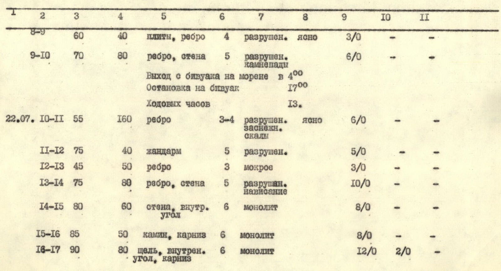
| 22.07. | R10–R11 | 55 | 160 | edge | 3–4 | Destroyed, snow-covered | clear | 6/0 | - |
| R11–R12 | 75 | 40 | gendarme | 5 | Destroyed | 5/0 | - | ||
| R12–R13 | 45 | 50 | edge | 3 | Wet | 3/0 | - | ||
| R13–R14 | 75 | 80 | edge, wall | 5 | Destroyed, overhang | 10/0 | - | ||
| R14–R15 | 80 | 60 | wall, inner corner | 6 | Monolithic | 8/0 | - | ||
| R15–R16 | 85 | 50 | chimney, cornice | 6 | Monolithic | 8/0 | - | ||
| R16–R17 | 90 | 80 | crack, inner corner, cornice | 6 | Monolithic | 12/0 | 2/0 |
Bivouac normal. Departure at 8:00. Stop for bivouac at 18:00. Climbing hours — 10.
| Date | Designation | Average steepness in degrees | Length in m | Character of relief | Difficulty | Condition | Weather conditions | Pitons (rock/ice) | Pitons (bolted) |
|---|---|---|---|---|---|---|---|---|---|
| 1 | 2 | 3 | 4 | 5 | 6 | 7 | 8 | 9 | 10 |
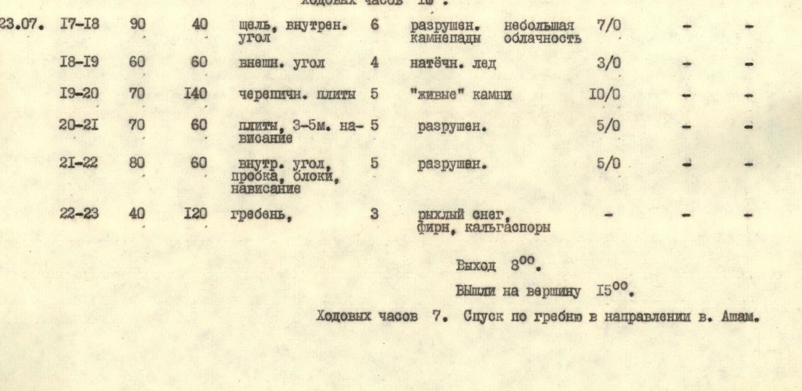
| 23.07. | R17–R18 | 90 | 40 | crack, inner corner | 6 | Destroyed, rockfall | partly cloudy | 7/0 | - |
| R18–R19 | 60 | 60 | outer corner | 4 | Flow ice | 3/0 | - | ||
| R19–R20 | 70 | 140 | tiled slabs | 5 | "Live" stones | 10/0 | - | ||
| R20–R21 | 70 | 60 | slabs, 3–5 m overhang | 5 | Destroyed | 5/0 | - | ||
| R21–R22 | 80 | 60 | inner corner, plug, blocks, overhang | 5 | Destroyed | 5/0 | - | ||
| R22–R23 | 40 | 120 | ridge | 3 | Loose snow, firn, calga | - | - |
Departure at 8:00. Reached the summit at 15:00. Climbing hours — 7. Descent along the ridge in the direction of Asham peak.
Ascent description
(Brief explanation to the table)
July 19, 1978. At 10:00, the team in full strength with equipment and supplies left the base camp at Lake Zardif to organize a bivouac on the lateral moraine of the glacier under the North face of Pik Luknitskogo. Travel time — 4 hours. We approached the wall. We observed the rockfall regime and clarified the start of the route. At 20:20, we returned to the base camp.
July 20, 1978. At 10:00, we left the base camp and at 13:00 approached the bivouac on the moraine. We planned to start the route at 4:00 am to be able to pass the lower part of the wall before the start of rockfalls.
July 21, 1978. At 4:00, we started, crossed the glacier, and at 5:00 began to ascend the wall. The North face begins with difficult climbing (5) up an inner corner and small ledges to the start of a couloir. Rocks fall in the couloir. We climbed one by one in a fast pace and reached a pronounced edge (R0–R1, R1–R2). Climbing along the edge is difficult, many "live" stones, rocks are wet (R3–R4, R4–R5). The edge leads under the 1st pronounced bastion. There are convenient places for a bivouac. The bastion is passed on the right side, climbing is very difficult, water flows continuously over the rocks. The relief of the bastion rocks is varied: inner corners, narrow chimneys, cracks, slabs (R5–R6, R6–R7, R7–R8). The bastion ends with an 80-meter destroyed wall, climbing is difficult, careful piton belay! Many loose stones! At 17:00, we stopped for the night at the start of the edge leading to the 2nd bastion. The place is safe. There is water. The bivouac is seated (R9–R10).
July 22, 1978. At 8:00, we started moving along the edge to the start of the 2nd bastion. The path is an alternation of snow, ice, and rock gendarmes with 2–3-meter sheer walls. Before the bastion, a counterfort turns into an 80-meter wall with sections of overhanging rock, rocks are heavily destroyed. The wall ends with a sharp ice crest, a counterfort (R11–R12, R12–R13, R13–R14). The wall of the 2nd bastion begins with an inner corner, which is interrupted by an overhanging slab, then along a chimney under a cornice, bypassing it with sheer walls, partly "negative"! Climbing is very difficult, we used ladders. From the cornice — free climbing to a small ledge and further along the system of cracks and fissures to the bivouac site. There is a platform laid out by the first ascenders (R14–R15, R15–R16, R16–R17).
July 23, 1978. At 8:00, we started moving along a crack turning into an inner corner. Climbing is very difficult. "Live stones"! (R17–R18). The corner leads to tiled slabs with small walls. Along an inner corner with a plug, we reach a small saddle and further along the wall, composed of large monolithic blocks, we reach the snow dome of the summit (R21–R22). Along a snow slope covered with calga, we reach the summit at 15:00.
The weather starts to deteriorate. In the area of Pik Marxa and Pik Engel'sa, black clouds and strong thunder. We descend along the snow ridge in the direction of Asham peak. Then along the glacier, we approach the bivouac on the moraine. During the descent along the glacier, we assisted Chelyabinsk tourists with their descent.
July 24, 1978, we returned to the base camp at Lake Zardif.