Ascent Passport
- Ascent class — technical
- Ascent area — South-West Pamir
- Peak; its height, ascent route — Peak Luknitskogo 5800 m, North face
- Proposed complexity category — 6B
- Route characteristics: height difference 1630 m, avg. slope 70°, section lengths:
- 3rd diff. cat. — 190 m
- 4th diff. cat. — 330 m
- 5th diff. cat. — 620 m
- 6th diff. cat. — 400 m
- Pitons driven:
- for belaying: rock 169, ice 3, bolt 13
- for artificial aids: rock 27
- Total climbing hours — 74 h
- Number of bivouacs and their characteristics — 6 bivouacs, including 3 sitting bivouacs
- Surname, name, patronymic of the team leader, participants, and their qualifications:
- Kavunenko Vladimir Dmitrievich, 1935, Master of Sports of International Class, "Spartak" Moscow, Ferganskaya st., 41
- Sviridenko Vadim Sergeevich, 1937, Master of Sports, "Avangard" Odessa, Kosmonavtov st., 44, apt. 59
- Kondakov Evgeny Ivanovich, 1936, Master of Sports, "—" Sumy, Lenina st., 13, apt. 8
- Vlasenko Alexander Ivanovich, 1941, Candidate for Master of Sports, "—" Odessa, Zaslavskogo st., 21, apt. 14 "B"
- Stavnitser Alexey Mikhailovich, 1942, Candidate for Master of Sports, "—" Odessa, Yaroslavskogo st., 45, apt. 18
- Smirnov Evgeny Germanovich, 1940, Master of Sports, "Spartak" Moscow, Pervomayskaya st., 1, apt. 112
- Bashkirov Vladimir Leonidovich, 1952, Candidate for Master of Sports, "—" Moscow Region, Kaliningrad, Kommunalnaya st., 34/7, apt. 10
- Ivanov Nikolai Vladimirovich, 1946, Candidate for Master of Sports, "—" Moscow, 5th Parkovaya st., 56, apt. 65
- Team coach — Naumov A.F.
- Date of departure and return — July 8–16, 1977
Peak Luknitskogo 5800 m
Brief geographical description of the work and climbing conditions
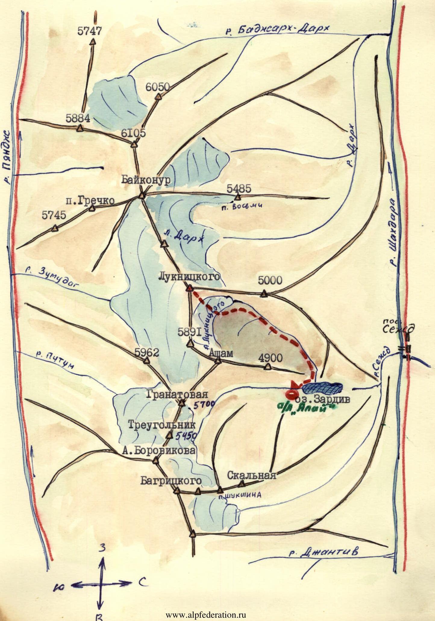
Peak Luknitskogo 5800 m is named after the first Russian researcher of the ridge, located in the western part of the Shakhdarin ridge in the South-West Pamir, between the peaks Bezymyanaya 5891 m to the east and Baykonur 6038 m to the west.
To the northwest, a short spur with a peak Bezymyanaya 5000 m branches off steeply from Peak Luknitskogo, separating alluvial valleys of the rivers Sezhd and Dzharh.
Under the broad northeast face of Peak Luknitskogo, a relatively calm Luknitskogo glacier flows down from the Shakhdarin ridge between the peaks Bezymyanaya 5891 m and Baykonur 6038 m.
The stream from under which flows into Lake Zardiv, which is one of the sources of the Sezhd river, flowing into the full-flowing Shakhdara near the settlement of Sezhd.
Under the northwest walls of Peak Luknitskogo lies a small Dzharh glacier, feeding the eponymous river, which flows northwest and flows into Shakhdara much west of the settlement of Sezhd. The approaches to the north walls of Peak Luknitskogo from the settlement of Sezhd, where good automobile roads lead, pass along convenient pack trails.
Under the southern walls in a large circus formed by the peaks 5962, Granatovaya, Asham, 5891, Baykonur, Peak Grechko, 5745 with Peak Luknitskogo in the center, lies the Zugmund glacier, the eponymous river, which flows into the Pyandzh.
In 1904, the area was visited by an expedition led by B. A. Fedchenko, who first described it in the "Proceedings of the Imperial Botanical Garden". Seventy years later, the area was first explored by climbers-reconnaissance led by Master of Sports of International Class V. P. Nekrasov. Already since 1975, its mountaineering development began. Climbers of the Armed Forces of the USSR in 1975 and 1976, as part of the Union championship, declared the north faces (northwest and northeast) of Peak Luknitskogo.
In 1975, army climbers led by V. Nekrasov made a re-ascent to the peak Bezymyanaya (assuming it was Peak Luknitskogo) via the simplest NW ridge, rated as a 5B category route. In 1976, a team of army climbers led by A. Mikhailov ascended Peak Luknitskogo via the NW wall.
The harsh North face of Peak Luknitskogo, requiring more serious technical and especially tactical preparation, remained unconquered until 1976. A 1.5–1.3 km rock face of the North wall, several hundred meters wide at the top, is pressed down by a huge 20–30-meter continuous cornice along its entire length.
The wall is almost entirely swept by:
- rockfall;
- water flows;
- and rare ribs are interrupted by vertical bands of rocks — one of the serious obstacles to passing the wall.
In 1977, for the third consecutive season, two teams from Sverdlovsk and a/l "Alay" submitted applications for an assault on the North face of Peak Luknitskogo.
Weather conditions in the area are favorable for mountaineering ascents, similar to the entire South-West Pamir. During more than a month of activity of a/l "Alay" under Peak Luknitskogo:
- there were only two days of bad weather;
- only one of them fell during the team's passage of the North face of Peak Luknitskogo.
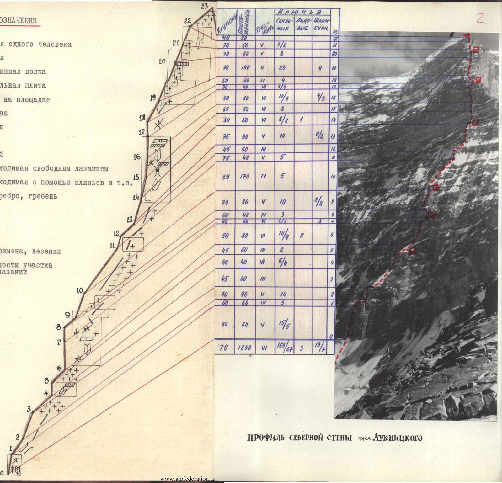
Conventional symbols
- Narrow ledge for one person
- Ledge for two
- Wide or long ledge
- Wall, vertical slab
- Good bivouac on a site
- Uncomfortable bivouac
- Inner corner
- Rocks
- Rocks with a plug
- Crack, passable by free climbing
- Crack, passable with wedges, etc.
- Outer corner, rib, ridge
- Overhang
- Cornice
- Snow, ice
- Ladders, stairways required
- Difficulty category of the section during free climbing
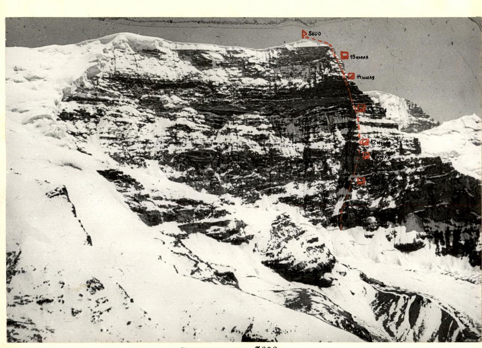
Profile of the North face of Peak Luknitskogo
| Section # | Slope (°) | Length (m) | Difficulty | Rock (belay/art. aids) | Ice (belay/art. aids) | Bolt (belay/art. aids) |
|---|---|---|---|---|---|---|
| R22–R23 | 70 | 40 | 5 | 9/2 | ||
| R21–R22 | 70 | 60 | 5 | 8/0 | ||
| R20–R21 | 70 | 140 | 5 | 23/0 | 4/0 | |
| R19–R20 | 60 | 60 | 4 | 4/0 | ||
| 90 | 40 | 6 | 6/4 | |||
| R18–R19 | 90 | 80 | 6 | 10/6 | 4/3 | 16/0 |
| R17–R18 | 85 | 50 | 6 | 8/0 | 15/0 | |
| 80 | 60 | 6 | 8/2 | 1/0 | 14/0 | |
| R16–R17 | 75 | 90 | 5 | 10/0 | 0/2 | 13/0 |
| R15–R16 | 45 | 50 | 3 | 12/0 | ||
| 75 | 40 | 5 | 5/0 | |||
| R14–R15 | 55 | 170 | 4 | 5/0 | 10/0 | |
| R13–R14 | 70 | 80 | 5 | 10/0 | 2/2 | 9/0 |
| R12–R13 | 60 | 40 | 4 | 3/0 | 8/0 | |
| 90 | 50 | 6 | 8/2 | 7/0 | ||
| R11–R12 | 90 | 80 | 6 | 10/4 | 2/0 | 6/0 |
| R10–R11 | 45 | 60 | 3 | 2/0 | 5/0 | |
| 90 | 40 | 4 | 6/4 | 4/0 | ||
| R9–R10 | 45 | 80 | 3 | 3/0 | ||
| R8–R9 | 70 | 90 | 5 | 10/0 | 2/0 | |
| R0–R1 | 60 | 60 | 4 | 9/0 | 1/0 | |
| 80 | 60 | 5 | 15/5 | |||
| Total | 70 | 1630 | 6 | 169/27 | 3/0 | 13/4 |
Area map-scheme
Ascent description
Brief explanation to the table
On July 7, 1977, in the second half of the day, the team in full strength with gear and supplies made a transition from the base camp of the expedition to a pre-selected location for the assault camp "Morena" on the lateral moraine of the glacier under the North face of Peak Luknitskogo and began setting up the camp.
The transition took 4 hours.
July 8. At 6:00, one rope team began processing the lower part of the route, the second rope team observed and maintained radio contact.
The rest of the team, after completing the work on setting up the "Morena" camp, returned to a/l "Alay".
The rope team, having processed 140 m, descended to the "Morena" camp for the night by 14:00.
The greatest difficulty during processing was presented by a 60-meter wall and crossing a steep and wide rock couloir. The danger of rockfall requires working on these sections in early morning hours and at a fast pace.
July 9. In the "Morena" camp, 4 team members rise with loads from the base camp of the expedition, as well as a observation and radio contact group consisting of Candidate for Master of Sports, climbing instructor Zimnitsky E.P. and 1st sports category Yanchenkov V.F.
We carry out final sorting and preparation of gear, food supplies. The whole team discusses and decides on tactics and technique for passing route sections, observation, and radio contact.
July 10. At 5:00, the team in full strength with gear and supplies leaves the "Morena" camp and quickly overcomes the pre-processed sections.
The first rope team without backpacks, after crossing the couloir (end of processing), passes the destroyed rock wall and reaches the rib of the counterfort. Moving along the rib R2–R4, it reaches the sheer chimney R4–R5 with wet rocks and, after very complex climbing, reaches a convenient place for a bivouac under a rock bastion by 15:00.
Table of route characteristics
| Date | Designation | Avg. slope (°) | Length (m) | Terrain character | Difficulty | Condition | Weather | Rock (belay/art. aids) | Ice | Bolt | Time of exit and bivouac, climbing hours |
|---|---|---|---|---|---|---|---|---|---|---|---|
| July 8, 1977 | R0–R1 | 80 | 60 | Oblique ledge, inner corner, cracks | 5 | Destroyed by rockfall | Clear | 15/3 | Processing of the lower part. Exit at 6:00, return to assault camp 14:00. Climbing hours — 6 h | ||
| R1–R2 | 60 | 80 | Couloir | 4 | Monolithic, icy, rockfall | 9/0 | |||||
| July 10 | R2–R3 | 70 | 90 | Rib | 5 | Destroyed by rockfall | Clear | 12/0 | Exit from "Morena" camp at 5:00 | ||
| R3–R4 | 45 | 80 | Rib, firn | 3 | Icy | Stop for bivouac at 15:00 | |||||
| R4–R5 | 90 | 40 | Inner corner, chimney, cornice | 6 | Monolithic, icy, water flows during the day | 7/2 | 2/0 | Climbing hours 10 h. Bivouac normal. | |||
| July 11 | R5–R6 | 45 | 60 | Rib, firn, snow, rock outcrops | 3 | Icy | Clear | 2/0 | Exit from bivouac at 7:00 | ||
| R6–R7 | 90 | 80 | Wall, inner corner, cracks | 5 | Monolithic, icy | 11/6 | 2/0 | Stop for bivouac at 19:00. Climbing hours 12 h | |||
| R7–R8 | 90 | 50 | Cracks, system of crevices | 6 | Monolithic, icy, icicles, hanging rocks, ice | 8/2 | 2/3 | Bivouac normal. | |||
| July 12 | R8–R9 | 60 | 40 | Slabs, rib | 4 | Destroyed, icy, rockfall | 4/0 | Exit at 8:00. Stop for bivouac at 17:00. Climbing hours — 9 h | |||
| R9–R10 | 70 | 80 | Rib, slabs | 5 | Destroyed, slabs, rockfall | 10/0 | Sitting bivouac | ||||
| July 13 | R10–R11 | 55 | 170 | Rib | 3–4 | Snow-covered, destroyed rocks | Cloudy | 5/0 | Exit at 8:00. Stop for bivouac at 19:00. | ||
| R11–R12 | 75 | 40 | Sentinel rock | 5 | Destroyed, icy | 5/0 | Climbing hours — 11 h | ||||
| R12–R13 | 45 | 50 | Rib | 3 | Snow-covered | Sitting bivouac | |||||
| R13–R14 | 75 | 90 | Rib turning into a wall | 5 | Destroyed, hanging section 3 m | 10/0 | 2/0 | ||||
| July 14 | R14–R15 | 80 | 60 | Wall, inner corner | 6 | Monolithic | 8/2 | 1/0 | Exit at 8:00 | ||
| R15–R16 | 85 | 50 | Chimney, cornice | 6 | Monolithic | 8/0 | Stop at 20:00. Climbing hours — 10 h | ||||
| R16–R17 | 90 | 80 | Crack, inner corner, cornice | 6 | Monolithic | 10/6 | 4/3 | ||||
| R17–R18 | 90 | 40 | Crack, inner corner | 6 | Destroyed, rocks, rockfall | 6/4 | Sitting bivouac | ||||
| July 15 | R18–R19 | 60 | 60 | Outer corner | 4 | Ice crust | Clear, cloudy | 4/0 | Exit at 8:00. Stop for bivouac at 18:00. | ||
| R19–R20 | 70 | 140 | Slabs, "tiles" | 5 | "Live" stones, ice crust | 23/0 | 4/0 | Climbing hours 10 h | |||
| July 16 | R20–R21 | 70 | 60 | Slabs, hanging sections 3–5 m | 5 | Ice crust, clear, destroyed, rockfall | 8/0 | Exit at 8:00 | |||
| R21–R22 | 80 | 60 | Inner corner, plug, hanging blocks in upper part | 5 | Destroyed, blocky | 10/0 | 2/0 | At 12:00, reaching the summit. Climbing hours — 4 h | |||
| R22–R23 | 40 | 70 | Ridge, firn, cal-gospores | 3 | Dense snow, firn |
By 18:00, all team members gather together on the site of camp #1. 6 people descend to the "Morena" assault camp for the night on the same day, to rise to camp #1 with the remaining gear the next day.
July 11. At 5:00, 6 participants exit the "Morena" camp with gear and reach camp #1 by 12:00.
At 7:00, a rope team begins passing the bastion from camp #1. The ascent route is planned slightly to the right of the central part of the wall due to the danger of falling ice and rocks.
From the bivouac, a snowy rib R5–R6 with rock outcrops leads to the wall. The ascent up the wall in the first half (80 m) goes up to the right along a discontinuous narrow ice-filled ledge.
Further, the ledge turns into a narrow vertical R7–R8 crack with hanging sections of rocks and ice.
Water flows present a serious difficulty throughout the ascent. This required complete re-dressing after passing "wet" areas.
The first rope team set up a tent immediately after passing the wall. The third participant climbed to the bivouac site at the end of the day with a supply of dry clothes, food, fuel, and a stove.
July 12. At 8:00, the trio at the top of the bastion passes a section of ice-filled slabs R8–R9 and reaches a 80-meter destroyed wall R9–R10 by 17:00. The rest of the team pulls up backpacks along the R8–R10 plumb line, finishing by 17:00.
July 13. At 8:00, they begin moving along the rib of the counterfort R10–R11. The path is a mix of snow, ice, and rocks with individual climbs, sentinels, 2–3-meter sheer walls.
The overall direction of the rib is towards the monolithic wall of the second bastion.
Directly before the bastion, the counterfort turns into an 80-meter rock wall with a hanging 5-meter section.
The rocks are heavily destroyed.
The wall ends with a sharp ice ridge, where a sitting bivouac was organized with great difficulty.
The first rope team begins processing the wall of the bastion. After the destroyed rocks of the rib, the monolithic rocks of the bastion are a true delight.
July 14. From the bivouac up along a crack in the slab. Complex climbing, sometimes using ladders. Further, a 30-meter inner corner interrupted by an overhanging slab. Entry into a 35-meter chimney blocked by a 2-meter cornice. Exit under the cornice and circumvention of the cornice along 100° slope rocks. Above the cornice — a small ledge for one person. Pulling up backpacks. Participants climb on jumar along a free-hanging rope. From the cornice — a 14–15-meter chimney formed by a split and a sheer main wall. Along a 10–12-meter crack with ladders, entry into an inner corner closed at the top by a small cornice. From the cornice — free climbing to a small ledge for 2 people. Pulling up backpacks. Along a system of cracks and crevices (tiles, live stones) to the bivouac site. Laying out a platform. Poor bivouac.
July 15. From the bivouac, left and up along rocks filled with ice (40 m). Exit to "tiled" rocks. Many "live" stones. "Tiled" rocks are interrupted by slabs. We move very carefully, yet the rope pulls down "live" stones. Annoyed by falling fragments of melting ice crust. Very tense work. One of the ropes is cut by a rock. We reach a small balcony. 120–150 m to the top of the wall. Laying out a platform. A duo processes a 60-meter inner corner and secures the belay under a small overhanging wall. Satisfactory bivouac.
July 16. We rise at 5:00. Very cold. The trio exits along the processed section. Overhanging wall. Blocky destroyed rocks seem very reliable after yesterday's "tiles". Along an inner corner made of blocks, we exit onto a snowy dome. 70–80 m along a slope covered with cal-gospores. Summit. Descent via V. P. Nekrasov's recommendation through the saddle between Peak Luknitskogo and Peak 5891, further down along the Luknitskogo glacier.
Tactics definition
- Along the route.
As a result of observing the wall, it was established that the lower part of the wall should be passed in the morning at a fast pace, as rocks start falling after 9:00.
The first "bastion" is completely filled with water from 10:00. Until 10:00, the rocks are covered with ice crust. One of the key places on the wall.
The first rope team stopped for bivouacs every day, not returning along the processed route.
The most dangerous part was the upper part of the wall — destroyed rocks.
The group's movement was organized clearly. There were no falls or injuries.
- By participants.
All participants have extensive experience in wall ascents, are physically well-prepared, love and know how to climb first. Before the declared route, 2–3 ascents up to 5B category inclusive were made.
Route conclusion
Based on the experience of passing similar routes (a total of over 100 routes of 5B category passed by participants), the group believes that the route passed corresponds to the 6B complexity category.
Coach A. Naumov
Ascent leader V. Kavunenko
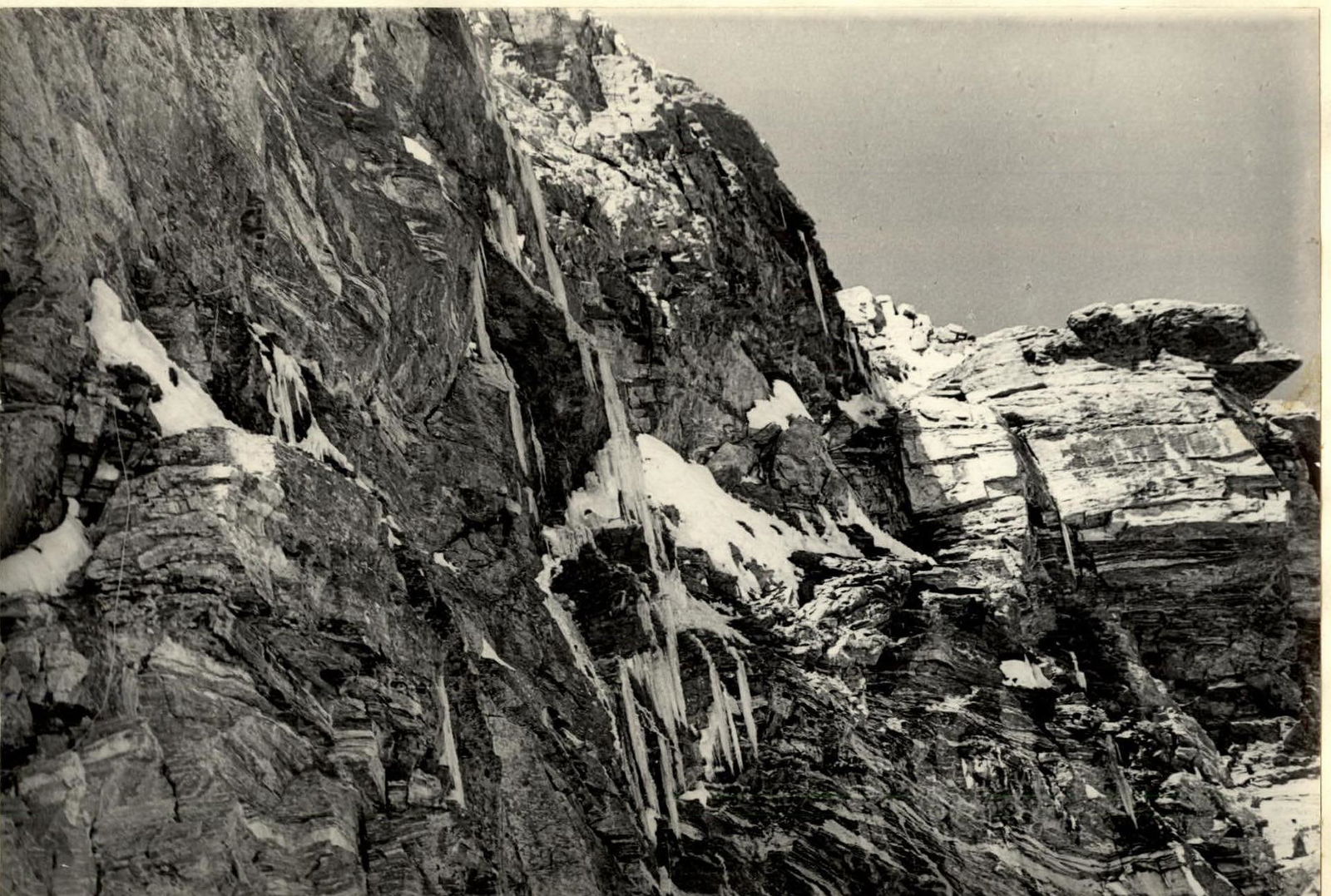
Section R4–R5
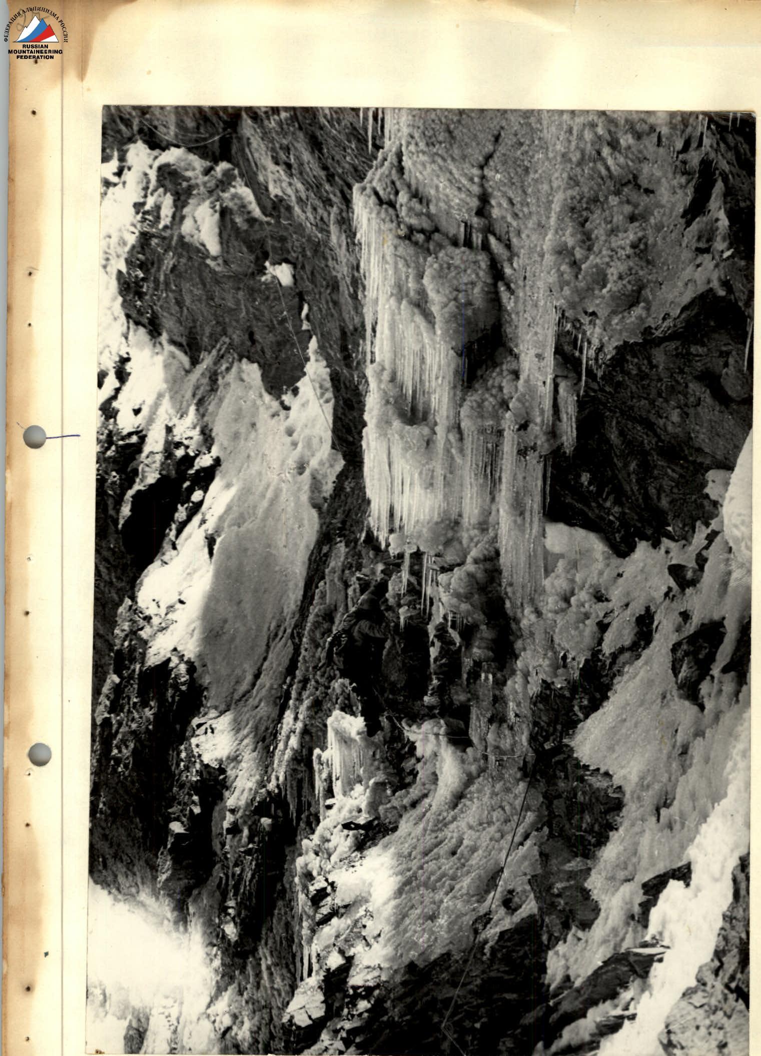
Pulling up a backpack. Section R6–R8

Performance of a participant. Section R6–R8
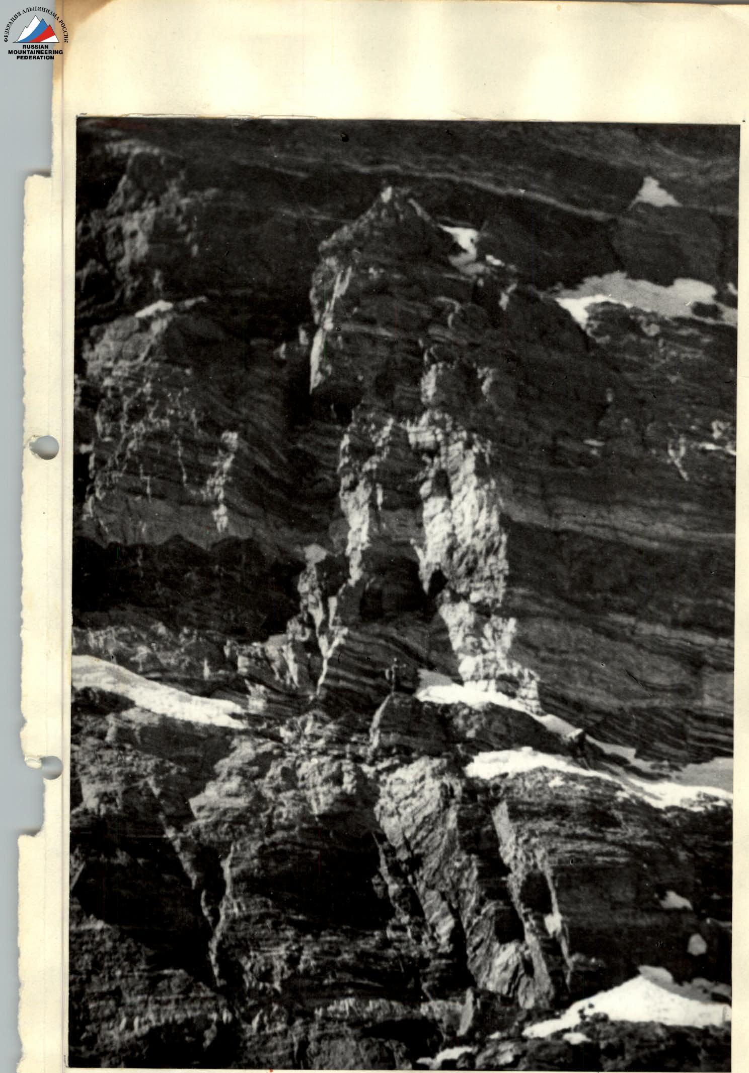
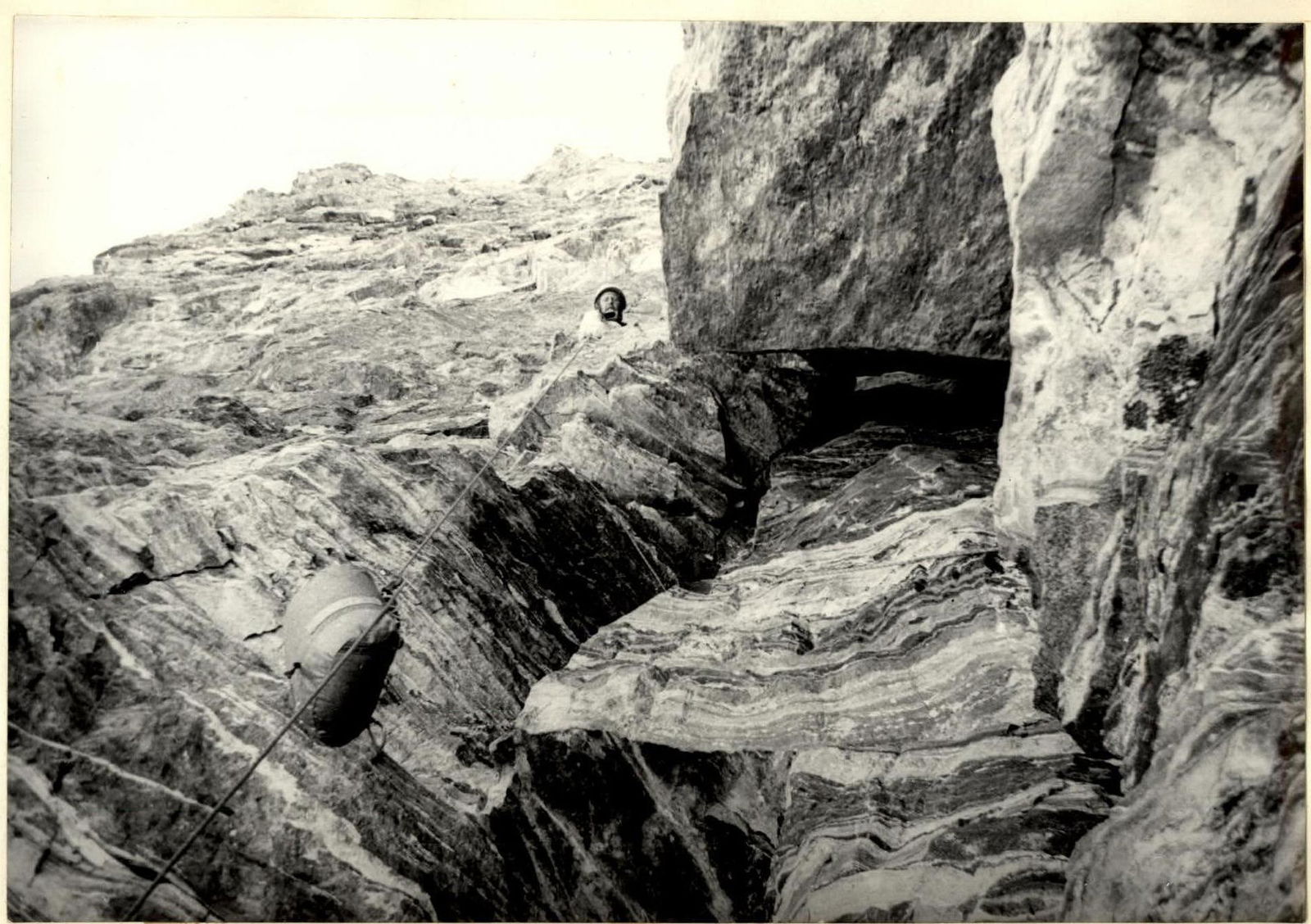
Section R13–R14
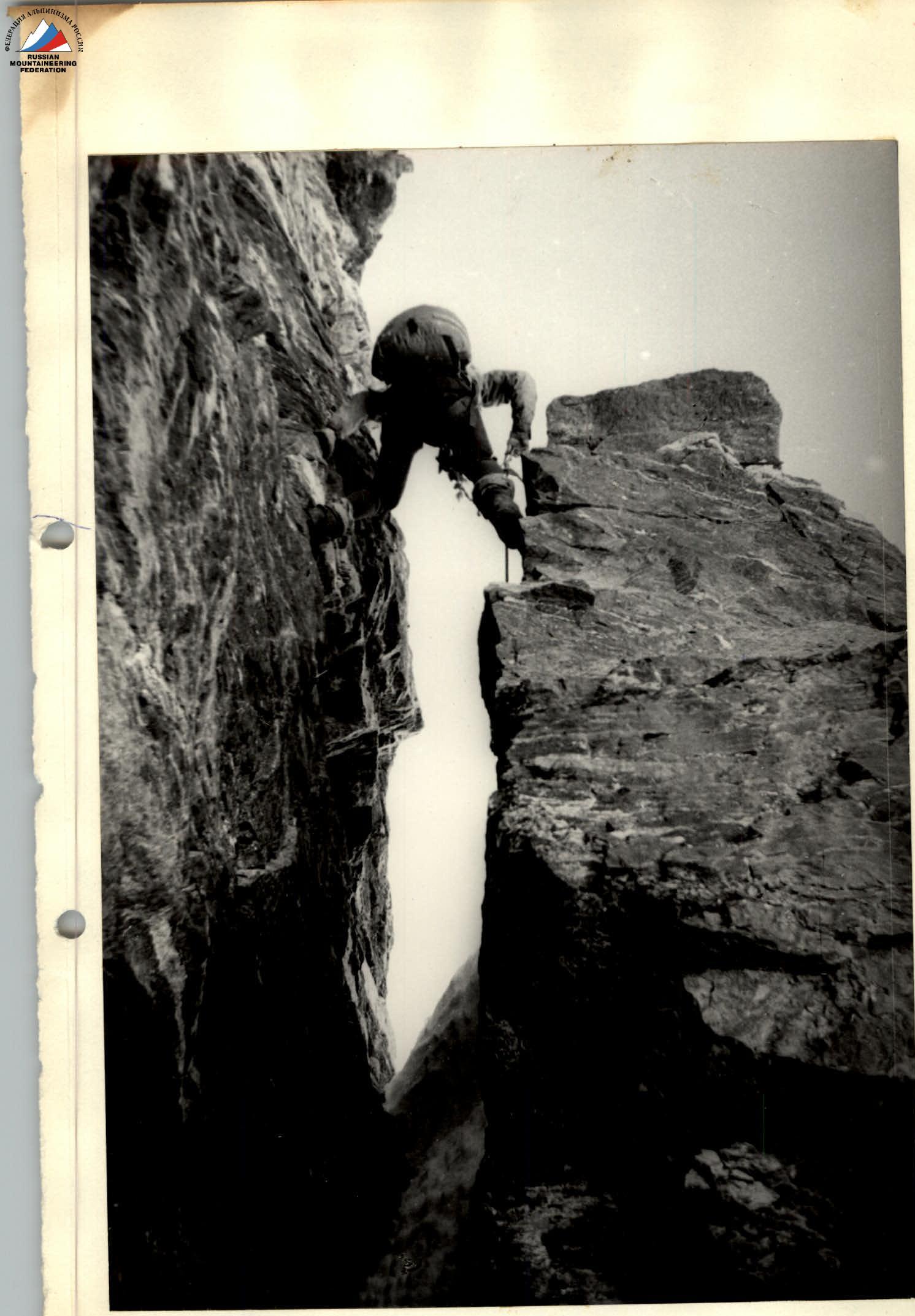
Section R15–R16

Section R16–R17
Section R17–R18