USSR ALPINISM CHAMPIONSHIP 1981
High-altitude technical class
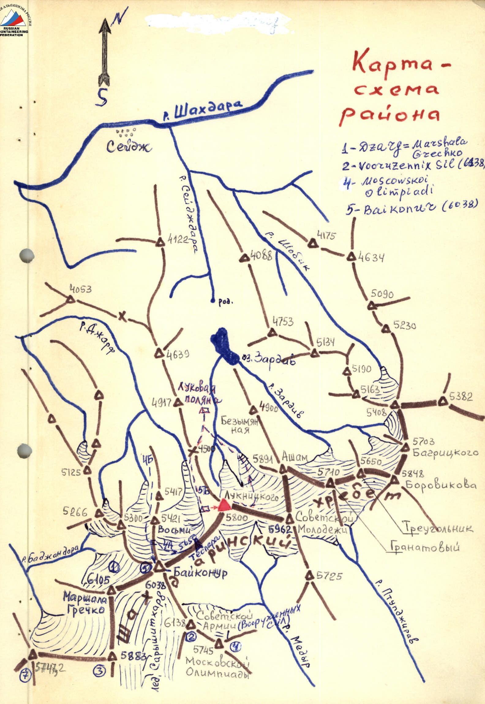
Shakhdarin Range — Peak Luknitskogo (5800 m) via the center of the western wall (first ascent)
Team of the Sports Committee of the Tajik SSR
Leader: V.I. Lavrukhin. Coach: V.I. Galaktionov.
Dushanbe — 1981
BRIEF GEOGRAPHICAL DESCRIPTION AND SPORTS CHARACTERISTICS OF THE ASCENT OBJECT
Peak Luknitskogo (5800 m) is located in the middle part of the Shakhdarin Range, in the main ridge, between the peaks 5962 m (Peak Soviet Youth) to the east and 6038 m (Peak Baikonur) to the west.
From the summit, the following relief forms extend in different directions:
- To the northwest, a ridge descends steeply, dividing the northern valleys of the Seyj (with Luknitskogo Glacier) and Jarf (with Jarf Glacier) rivers.
- To the south, snow-ice slopes descend, ending in glaciers that form the Medyr River, a tributary of the Pyanj River.
- To the north and west, Peak Luknitskogo drops with sheer walls.
The expedition's base camp was located on a meadow (3900 m) on the Sейдж River, two kilometers above Lake Zardiv. The meadow can accommodate a Mi-8 helicopter, which was used for transportation and evacuation. The lower helicopter landing site is located at the confluence of the Shakhdara and Bajomdar rivers. A good road passes through this area (distance from Khorog — 70 km).
The approach to the route from the base camp through the Zardiv Pass (4500 m) in the northwest ridge of Peak Luknitskogo takes 3 hours.
Alpinist exploration of the area began in 1975 by army climbers led by V.P. Nekrasov, and Peak Luknitskogo was climbed via the Northwest ridge. As part of the USSR Climbing Championships, two routes have been ascended to Peak Luknitskogo:
- via the western wall (A. Mikhailov, 1976, IV place)
- via the northern wall (V. Kavunenko, 1977, III place)
Geologically, the area is represented by a complex of metamorphic rocks:
- shales,
- marble,
- sandstones,
- limestones,
- conglomerates, etc. Magmatic formations are absent. A characteristic feature of the composing rocks is their strong destruction.
Climatically, the area is warm with stable good weather. However, 1981 was not typical in terms of weather conditions. During the expedition's stay at the base camp (July 15 – August 20), 50% of the days were unfavorable (rain, snow).
- Ascent tactics definition.
As a result of reconnaissance and observations, the Western wall of Peak Luknitskogo can be conditionally divided into three sections:
- I bastion (4500 m – 4900 m)
- II bastion (5100 m – 5200 m)
- III bastion (5380 m – 5800 m)
The bastions are connected by ice slopes with rock outcrops and ice formations.
On the rocks of I and II bastions, in the first half of the day, ice formations and icicles are possible, while in the second half of the day, water (wet rocks) from melting snow on the ledges is expected. Individual falling stones in the second half of the day do not pose a danger to participants on I and II rock bastions due to the steepness of the rocks.
The lower ice slope is planned to be traversed in the early hours when there are no rockfalls.
The key section of the route is III bastion — a 400-meter wall that overhangs throughout its entire extent. The "soft rock" zone poses the greatest difficulty.
Information about it was obtained from:
- participants of previous expeditions to this area,
- a group of climbers from our expedition, Suzdalev–Kanaev, who ascended via the Mikhailov route to Peak Luknitskogo immediately before our ascent.
The group also established that there are no signs of falling stones on the ice slopes above the second bastion, allowing us to traverse this section at any time of day.
On the day of processing, it is planned to hang four 60-meter ropes on the rocks of I bastion. On the second day, we will traverse the processed ropes and then ascend I and II bastions. The third bastion requires preliminary processing of the route.
Six bivouacs are planned on the route:
- bivouac 1
- bivouac 2
- bivouac 3
- bivouac 4
- bivouac 5
- bivouac 6
Provisions are planned with a two-day reserve in case of bad weather.
The work of the rope teams on the route is possible in any combination, given the complete coordination among all participants. The route is decided to be traversed with preliminary processing. From 14:00 to 15:00, the first rope team prepares the next day's route from the next bivouac site, while the second rope team traverses the previously hung fixed ropes, removes them, pulls up backpacks, and prepares the site."""
The generally accepted tactic is modified for the first two days after processing the route. Considering that the ice and rock sections after the first day are not complex enough to significantly slow down the ascent rate and reduce the time spent by the groups on potentially rockfall-prone slopes, it is decided to traverse the first two days without preliminary processing.
The processing on the first day aimed to:
- test and finalize the equipment;
- outline (refine) the possible location of the first bivouac;
- test the movement schedule along the route during the day.
All bivouacs are planned to be set up on safe platforms under the cover of walls, overhangs, etc.
As a result of reconnaissance, observations, ascents by the parallel route of the Suzdalev–Kanaev group, study of previous expedition reports, and personal consultations, the present tactical plan was developed, the ascent route was finally chosen, equipment and provisions were selected, and communication was tested: group — observer — base camp — Dushanbe.
The list of products and equipment taken on the route is attached.
ASCENT DESCRIPTION
August 7, 1981. Morning, 10:00. As planned by the tactical plan, today the Lavrukhin–Aizenberg rope team is processing the bastion (the first key of the route). The weather is good in the morning.
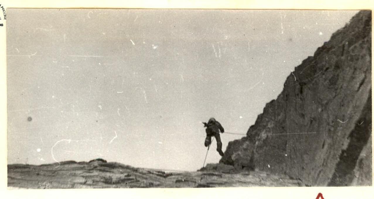
The processing results should confirm the correctness of the chosen tactics for traversing the route, selecting a safe ascent option, choosing a safe first bivouac, giving final recommendations on equipment selection, and processing 250 m of complex rocks of the first bastion, which is accessed via a snow-ice slope (photo # 1), with a steepness of up to 40°, and a length of 250 m (section R0–R1). In "cats," we quickly approach a clearly defined counterfort. The route passes through the wall of the counterfort via a "white spot" in the direction of the left, torn internal angle. The rocks have a "shingled" structure, with a steepness of up to 80° and numerous small overhangs up to 1 m (photo # 2), difficult to traverse due to their destruction. Climbing is done using pitons. After 7 hours of complex climbing, we approach the internal angle (section R1–R2), the entrance to which is blocked by a 1.5-meter cornice (photo # 3). The weather starts to deteriorate (it has been precipitating after noon for several days), light snow falls, the rocks become wet, and visibility worsens to 50–70 m. We report via communication that we are stopping work, secure the last rope, and descend. In an hour, we are back in the tents. Thus, on the first day, 250 m of complex rocks of the first bastion were processed in 8 hours.
August 8, 1981. Last night, we received a good long-term weather forecast from Dushanbe, which is encouraging, as today is a very intense day.
The planned bivouacs are located above the rocks of the first bastion, which is more than 500 m of altitude gain.
Early rise, and by 8:00, the group is on the route, following the hung ropes. The weather is good in the morning. Backpacks are transported on "harnesses" (American method) on complex sections, significantly reducing the time taken to traverse the fixed ropes.
Today, the Aizenberg–Belyntsev rope team leads, while the second team removes the fixed ropes, drops unnecessary equipment, and prepares three walking backpacks. (The first team works without a backpack). Further processing of the route begins by traversing a 1.5-meter cornice with an entry into an 85° internal angle (photo # 4), which is partially blocked by a 3-meter overhang and passes —
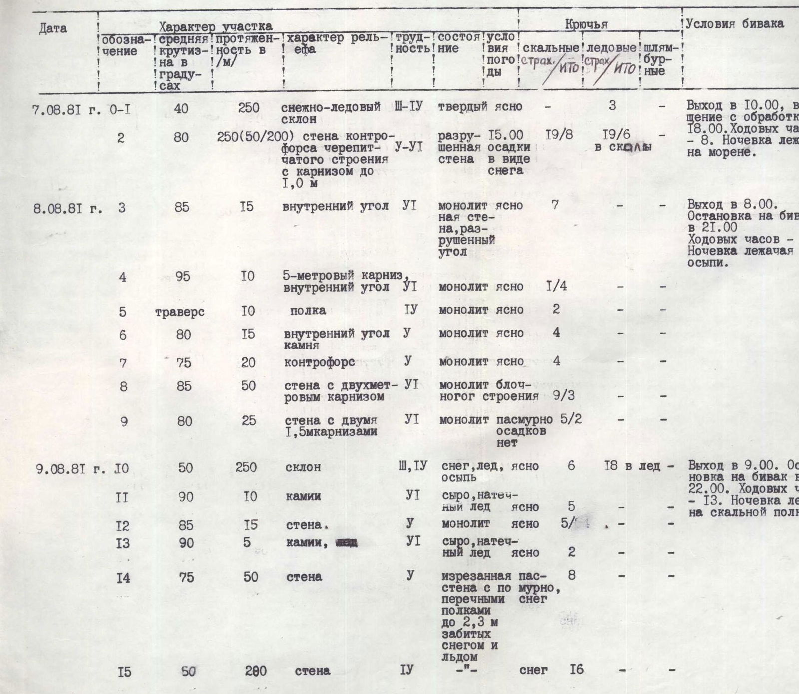
TABLE OF ROUTE CHARACTERISTICS
| Date | Designation | Average steepness, ° | Length, m | Relief characteristics | Difficulty | Condition | Weather conditions | Pitons (rock/ITO) | Pitons (ice/ITO) | Bolted | Bivouac conditions |
|---|---|---|---|---|---|---|---|---|---|---|---|
| August 7, 1981 | R0–R1 | 40 | 250 | snow-ice slope | 3–4 | hard | clear | 3 | - | - | Departure at 10:00, return from processing at 18:00. Climbing hours — 8. Bivouac on moraine, lying. |
| R2 | 80 | 250 (50/200) | wall of counterfort with "shingled" structure and 1.0 m cornice | 5–6 | destroyed wall with snow sediment | 15:00 precipitation | 19/8 | 19/6 into rocks | - | ||
| August 8, 1981 | R3 | 85 | 15 | internal angle | 6 | monolithic wall, destroyed angle | clear | 7 | - | - | Departure at 8:00. Stop for bivouac at 21:00. Climbing hours — 13. Bivouac on scree, lying. |
| R4 | 95 | 10 | 5-meter cornice, internal angle | 6 | monolith | clear | 1/4 | - | - | ||
| R5 | traverse | 10 | ledge | 4 | monolith | clear | 2 | - | - | ||
| R6 | 80 | 15 | internal angle of rock | 5 | monolith | clear | 4 | - | - | ||
| R7 | 75 | 20 | counterfort | 5 | monolith | clear | 4 | - | - | ||
| R8 | 85 | 50 | wall with 2-meter cornice | 6 | monolith of block structure | clear | 9/3 | - | - | ||
| R9 | 80 | 25 | wall with two 1.5-meter cornices | 6 | monolith | overcast, no precipitation | 5/2 | - | - | ||
| August 9, 1981 | R10 | 50 | 250 | slope | 3–4 | snow, ice, scree | clear | 6 | 18 into ice | - | Departure at 9:00. Stop for bivouac at 22:00. Climbing hours — 13. Bivouac on rock ledge, lying. |
| R11 | 90 | 10 | chimneys | 6 | wet, ice formation | clear | 5 | - | - | ||
| R12 | 85 | 15 | wall | 5 | monolith | clear | 5/ | - | - | ||
| R13 | 90 | 5 | chimneys | 6 | wet, ice formation | clear | 2 | - | - | ||
| R14 | 75 | 50 | rugged wall with transverse ledges up to 2.3 m, filled with snow and ice | 5 | rugged wall with transverse ledges up to 2.3 m, filled with snow and ice | overcast, snow | 8 | - | - | ||
| R15 | 50 | 200 | wall | 4 | " | snow | 16 | - | - | ||
| August 10, 1981 | R16 | traverse | 40 | wall | 5 | blocks | clear | 4 | - | - | Departure at 18:00. Return at 19:00. Overnight at previous bivouac. Climbing hours — 9. |
| R17 | 90 | 20 | wall | 6 | monolith, fragmented | clear | 6 | - | - | ||
| R18 | 95 | 60 | internal angle with overhang | 6 | monolith | overcast, snow | 21/7 | 3 into rocks | 1 | ||
| August 11, 1981 | R19 | 95 | 70 | internal angle with 5-meter cornice overhang | 6 | monolith | clear | 24/20 | 2/3 into 3 rocks | Departure at 10:00. Stop for bivouac at 21:00. Climbing hours — 11. Bivouac sitting. No water. (Bivouac at the end of processing on August 10) | |
| R20 | 100 | 20 | overhanging wall | 6 | wall with vertical fissure, monolith | clear | 4/16 | 2 into rocks | 1 | ||
| August 12, 1981 | R21 | 95 | 50 | wall | 6 | destroyed "shingled" structure | clear | 13/18 | 9/11 into rocks | 1 | Departure at 9:00. Stop for bivouac at 21:00. Bivouac in triangular niche, sitting. |
| R22 | 95 | 60 | wall | 6 | monolith | clear | 14/20 | - | - | ||
| August 13, 1981 | R23 | 95 | 30 | "light" wall | 6 | monolith | clear | 10/9 | - | - | Departure at 9:00. Reach the summit at 20:30. Climbing hours — 11 h 30 min. Bivouac on summit, lying. |
| R24 | 95 | 50 | internal angle, wall | 6 | monolith | clear | 17/17 | - | - | ||
| R25 | 75 | 60 | wall | 5 | monolith | clear | 12 | - | - |
The route is generally safe, with only occasional sounds of falling icicles and stones hitting the glacier 50–100 m from the wall. By 19:00, the first rope team reached the top of the first bastion and began preparing a platform for the tent. The platform is on a scree slope under the cover of a rock outcrop. Preliminary processing is not required today, and by 21:00, the team is resting. The plan for today is fulfilled, with 550 m gained in 13 hours. Communication is normal. The weather is cloudy after noon but without precipitation.
August 9, 1981. 9:00, the Lavrukhin–Belyntsev rope team is the first to leave the tent. They lead today. After traversing a 50° ice slope 260 m long with rock outcrops and ice formations, we approach the walls of the second large bastion, which is also a rounded counterfort with a steepness of 80–85°, composed of "shingled" rocks. The direction of movement is straight up to the base of the third bastion, to the location where a huge internal angle descends. The main difficulty is traversing steep, wet chimneys (sections R10–R11 and R12–R13, photo # 6). Further, the route to the third bastion consists of alternating short rock walls with steepness 80–85° and ice-snow slopes with steepness 50–60°, interrupted by rock outcrops with ice formations. Bad weather starts earlier than usual, and by 13:00, snowfall begins; movement along the ice-snow slope continues in conditions of poor visibility (photo # 7). Independent rope teams leave pitons for the second team. In strong and bad weather, the team sets up a tent on a rock ledge under the cover of overhanging rocks of the third bastion only by 22:00 (photo # 8).
Despite the bad weather, the tactical plan is fully implemented. In 13 climbing hours, 620 m of the route were traversed, with more than half on ice and rocks covered in ice. Communication is normal — rest in continuing bad weather. Snowfall stopped only by morning.
August 10, 1981. After the snowfall, it is very cold and cloudless in the morning. The bastion is dry but looks menacing and gloomy. 400 m of 95° overhanging rocks. The key section of the entire route is ahead. Only at 10:00, the Lavrukhin–Kozlov rope team starts processing; the second team is to take over at 14:00. From the tent, we traverse 40 m to the right along a ledge to the base of a 130-meter huge internal angle. It starts 20 m above the ledge and is blocked by a 1.5-meter cornice. After traversing the cornice, we enter the angle and, after 40 m of complex climbing, reach a 2-meter overhang, which is traversed directly on the "ladders." The weather starts to deteriorate by 14:00; we instruct the second team, which has started its ascent, to remain below, while we continue processing the route. Climbing is very complex, and in deteriorating weather, we process another 20 m of rocks. A freely thrown 60-meter rope hangs 4 m from the rock, and we ask for it to be secured. By 19:00, we are in the tent. The bad weather is minor — fog, occasional light snow. Today, 80 m of overhanging rocks were processed in 9 hours.
August 11, 1981. 10:00. The weather is excellent. The Aizenberg–Belyntsev rope team ascends without backpacks along the processed ropes. Behind them, Lavrukhin and Kozlov follow, their task for today being to pull up the backpacks. From the end of the processed fixed ropes, the route continues another 20 m along an overhanging internal angle (section R18–R19, photos # 11, 12) and ends with a 5-meter cornice split by a vertical fissure (section R19–R20), which is traversed on "ladders" using "protection" and "étriers" (aid climbing), leading to the "soft" rock. We conclude processing the route for today. The second team has already relocated the bivouac to the end of the previous day's processed fixed ropes, where it is decided to set up a sitting bivouac on small ledges. Due to the lack of water, ice was pulled up from the lower ledges (photo # 10).
Thus, in 11 climbing hours, another 90 m of overhanging rocks were processed. Communication is normal. The weather is excellent.
August 12, 1981. Today is a crucial day; we need to process the "soft wall" (key section). At 9:00, Lavrukhin–Belyntsev start processing. After ascending the previously hung ropes, we begin processing the "soft" rock in the direction of a large (10×3 m) niche with an overhang. Specially made 25–30 cm titanium pitons are used. The wall is "alive" due to which movement is extremely slow, as finding cracks for reliable protection takes a lot of time.
Only by 14:00, having traversed a 50-meter wall, do we reach firmer monoliths. A complex 60-meter overhanging wall leads to a triangular niche by 18:00, where it is decided to set up another sitting bivouac (photo # 13).
By the time the entire team gathered in the niche (21:00), another 30 m were processed. Further, the route from the niche goes left (section R21–R22) in the direction of the summit (photo # 14). Climbing is tense, using "protection" to create "artificial" holds. In 12 hours, the team raised the bivouac by 170 m, processing an additional 30 m of the wall. The weather is excellent; communication is normal.
August 13, 1981. The weather is good in the morning. According to the plan, we should reach the summit today, which motivates everyone. Aizenberg and Kozlov, having traversed the processed 30 m of rocks, start working on the next 30 m (section R21–R22) of the wall in the direction of the "light" rocks. The relief does not change — 95°; "protection" and pitons are used.
The "light rock" zone (section R22–R23) is a monolithic wall, slightly recessed into the main wall. The direction of movement is straight up towards the summit. After 30 m, we approach the base of an internal angle formed by two overhanging cornices. Between them, along the angle, and then along the wall, 50 m (section R23–R24, photos # 15, 16) lead to a flattening of the wall to 75° (photo # 17). 60 m of relatively easier rocks lead to the summit, where everyone gathers by 20:30. In 11 hours and 30 minutes of climbing, the last 170 m of the third bastion are traversed.
The weather is excellent; we report via communication that we have reached the summit and are setting up for a bivouac.
August 14, 1981. The weather is excellent from the morning, and at 10:00, after a short preparation, we begin our descent along the eastern ridge of the summit to the saddle between Peak Luknitskogo and Peak 5962 (Peak Soviet Youth) and further down to the northern ice slopes. The team descends to the base camp by 18:00.
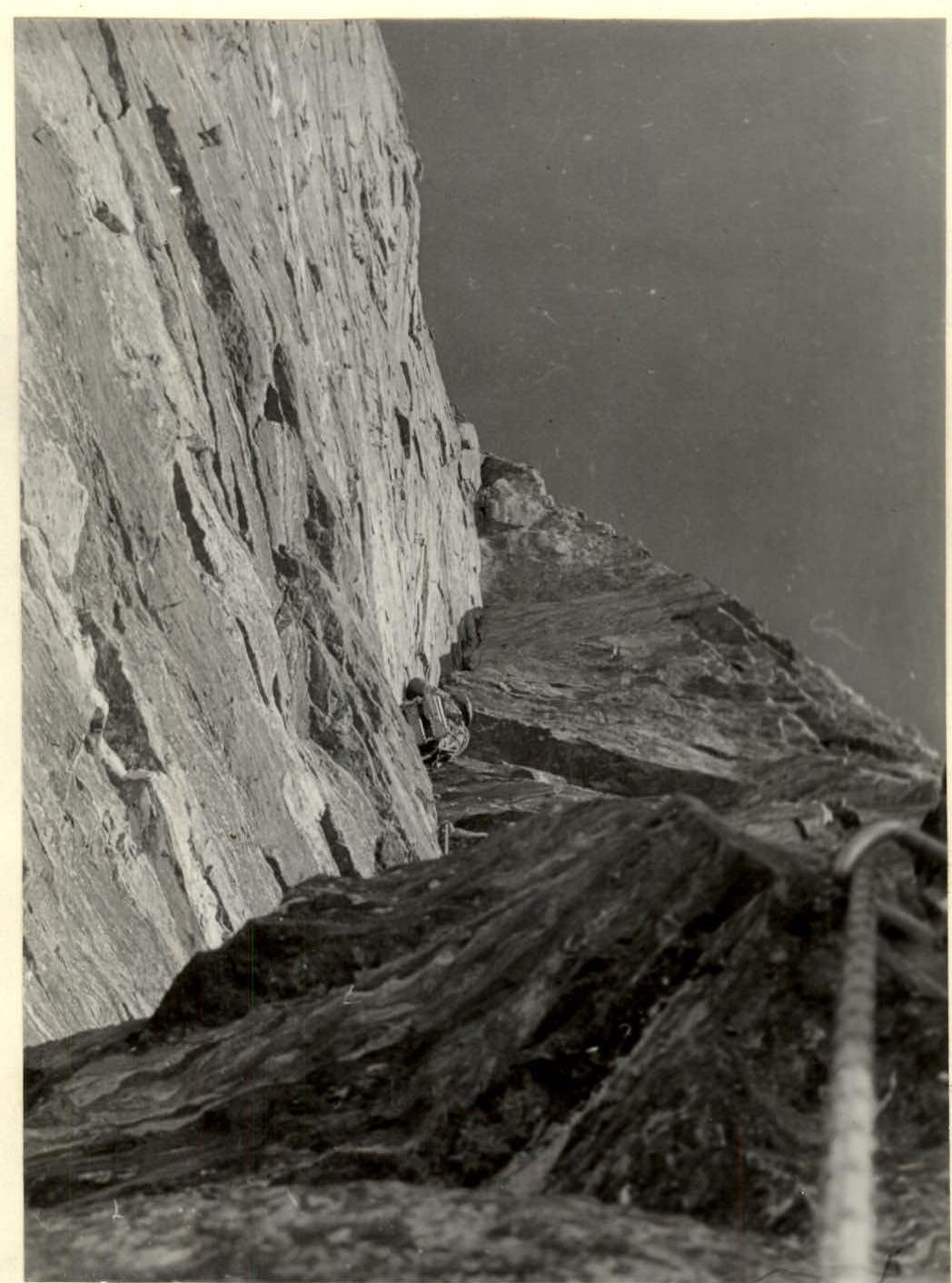
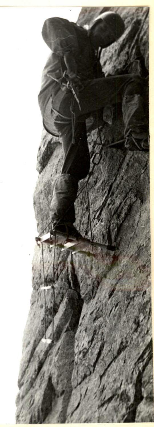
Photo 11. Section R18–R19. Giant overhanging internal angle of III bastion.
 Δ
Δ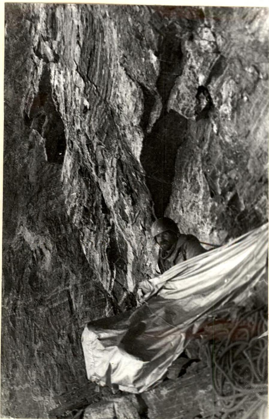
Photo 12. Section R19–R20. Ascending via fixed ropes for route processing.
Photo 13. < Bivouac in niche August 12, 1981
Photo 14. Section R21–R22. Processing next overhang of III Bastion.
Photo 15. Section R22–R24. Processing wall of III bastion.
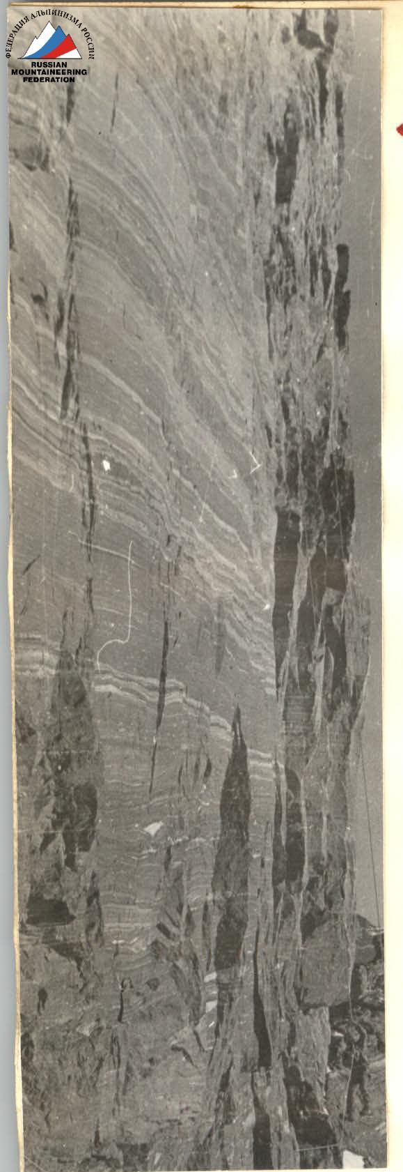
Photo 16. Section R22–R24. Traversing wall of III bastion via fixed ropes.
Photo 17. Section R24–R25. Final complex meters before the summit.