
Ascent Passport
- Ascent category: High-altitude technical
- Ascent area: Southwestern Pamir
- Ascent route with indication of peaks and their elevations. Ascent to the peak LITVA via the fourth bastion of the Southwest wall H = 6080 m.
- Characteristics of the ascent: height difference 1080 m; average steepness of the wall section 75–80°, length of the complex section 435 m.
- Number of pitons: rock 97, ice —, bolt —.
- Number of walking hours: 51.5.
- Number of bivouacs — their characteristics — 5. To obtain water, we melt ice.
- Team name: I team of the Lithuanian national team.
- Surname, name, patronymic of the leader, participants, and their qualification:
- Blažaitis Z.Yu. — Candidate for Master of Sports — leader
- Šukis A.B. — Candidate for Master of Sports — participant
- Yurgelionis Yu.P. — Candidate for Master of Sports — participant
- Buika A.A. — 1st sports category — participant
- Team coach A.V. Petrov.
- Date of departure and return: 26.07.1974 – 30.07.1974.
CHAPTER II. Conducting the Ascent
Route Description
Day I. 25.07.1974. From the base camp located in the Kish-ty-Dzherob valley H = 4200 m, we departed at 13:00.
The trail goes along the left (in the direction of travel) side of the river. Before the glacier tongue — a crossing to the right side. From here, the trail leads along a slope with a significant gain in height. After the first tributary of the Kish-ty-Dzherob river on the right (in the direction of travel), we turned off the trail. We went along the left side of the tributary (in the direction of travel), then turned towards a clearly visible median moraine of the glacier. We crossed the second tributary. Two team members went to retrieve the cached supplies. Along the middle of the moraine, a faint trail leads. We moved in the direction of a large conspicuous tent site under the slope of the Litva massif opposite the fourth bastion (counting from right to left). We stopped to study individual sections of our chosen objective from different distances using binoculars.
Along the middle and large moraines, we approached the designated location. There is enough space for setting up tents. There is water. During the initial observations and on the last day, there were no avalanches or rockfalls in the route area.
Day II. 26.07.1974. We departed at 7:00. The starting point of the wall section is marked by a small yellow direct counterfort, clearly standing out against the darker background of the slope.
We ascended a snowy slope with rocky outcrops and small walls covered with a thin layer of ice in the upper part. We used self-arrest. Without significant difficulties (0–1), we made steps and reached a small snow-rock platform at the foot of the counterfort. Starting the wall section from other locations did not seem appealing (photo 1).
The first two ropes (R1–R2) moved up through destroyed but not loose fourth-class rocks. The first climber went with a lightened rucksack (photo 2). There were good ledges for securing the rope. From here, a detached triangular-shaped boulder forming a chimney was clearly visible (R4). — A sharp change in direction to the left. — Traverse — bypassing the boulder along unclearly defined destroyed ledges and blocks (R2–R3) 45 m until joining the boulder to the wall (photo 4). — We traverse under a negatively inclined wall in some places. — Further (R3–R4) straight up into the chimney (photo 5).
We pulled up the rucksacks. On the boulder, we established the I control cairn.
From the cairn — a traverse to the left (R4–R5) under an overhang (photo 6). In the first few meters, we used 1×3 ladders. After traversing 0.5 ropes, it was expedient to organize the pulling up of rucksacks.
From here (R5–R6), we ascended a small destroyed shoulder through a deep niche. On this section, we needed to be cautious: — Many loose rocks; — The lower climber had no convenient shelter.
When pulling up rucksacks, we also needed to be very cautious: — Rucksacks got stuck; — Dislodged rocks.
We reached a platform near the red rocks at the wall at 21:00. We leveled and set up a bivouac. The platform was cramped but safe from rockfall. We secured the area with ropes. There was no water. We melted ice. Throughout the day, we had excellent, regular radio communication.
Day III. 27.07.1974. We departed at 9:00. As the previous day showed, in the morning, the rocks were cold. The sun appeared late, and climbing in gloves was not suitable in many places (R6–R7).
The first climber ascended in galoshes. The rocks were smooth (photo 7).
0.5 ropes straight up through a crack and to the left — a traverse with an ascent along a narrow ledge to an overhanging rock. We used a "diagonal" method to pull up rucksacks. We used ladders. Further up — to the left to a small ledge. When pulling up rucksacks, they got stuck. From the platform, there was a steep 30 m ascent to a gentle large talus. We pulled up rucksacks. We needed to be cautious — there were loose rocks above. If necessary, a bivouac could be organized here, but a rope higher up provided a safe ledge and a starting point for processing the most labor-intensive wall. From here, it was clearly visible.
Along large taluses, we moved towards an oblique crack, clearly visible in the smooth wall. It led to a ledge. We pulled up rucksacks. 18:00. We set up a bivouac. Along the wall, we secured ropes. The ledge was as wide as a tent, but long enough to set up several tents. There were no signs of rockfall. At the left end, there was enough ice. We examined the wall meter by meter, checking every hold. We decided to ascend under the triangular balcony, which was 30 m above our heads. The section looked impressive, requiring great rock climbing skill.
Day IV. 28.07.1974. We did not dismantle the bivouac, as the work ahead was going to be lengthy. 9:00. Šunis started working on the wall (R9–R10). He climbed with their double rope. The cracks were shallow, and pitons bent; we had to adjust our placement to find better holds. There were no holds on the entire section. All work was done using ladders. After 15 m, we switched. After traversing 30 m, there was a ledge (photo 8) where we could receive our partner for more sensitive rope management and extraction. We used a variety of pitons. Above the ledge (R10–R11), there was a wide crack formed by a detached slab. A large-section piton fit well into it. A couple of wooden wedges would have been useful. The weather began to deteriorate. We secured the ropes and descended. Along the way, we extracted some pitons.
Day V. 29.07.1974. At night, there was wind; from evening until mid-day, it snowed. We did not go on the route. A slight earthquake occurred. We were apparently far from the epicenter. We did not observe any collapses in the visible area. The reserve day was used. We reported the delay to the base camp. The releasing leader established another reserve day.
By 17:00, the weather normalized. A pair on étriers ascended to practice the exit from under the balcony (R11–R12). We ascended with utmost caution. We checked all the pitons hammered in the evening — they held firmly. The wall was clean and calm. The exit from under the balcony was along the left part. We worked with ladders. By 20:00, the pair descended to the bivouac. We constantly observed the wall's "behavior." It did not raise any doubts.
Day VI. 30.07.1974. Departure at 8:00. At the overnight location, we left the II control cairn. Above the triangular balcony, we ascended with étriers: here, the whole group could gather. We pulled up the rucksacks.
Overcoming the next wall (R12–R13) — with ladders. When choosing places for pitons, we needed to be very attentive due to many detached surfaces.
The next section (R13–R14) was traversed: — Traversing right along narrow ledges (photo 9); — Ascending blocks.
We used a "diagonal" method to pull up rucksacks. Along destroyed rocks (R14–R15), we ascended freely to a location we named "the Organ." It consisted of large icicles formed from water dripping from a terrace.
Behind "the Organ" at the wall — a good location for the belayer. The ascent along the negative wall (R15–R16) (photo 10) was physically and psychologically tense. We used ladders. We reached a terrace that was a joy to see. Other participants ascended using étriers. It was the best bivouac site. We pulled up the rucksacks. 17:00. Bivouac. At the bivouac: — No water; — We melted ice; — One rope team processed the wall (photo 11) that we would ascend tomorrow.
The ascent (R17–R18) along the wall with ladders, along an inclined slab — climbing up and to the right, ropes. We descended to the bivouac.
To move safely on the terrace (photo 12) and set up a tent, we needed to stay close to the wall. During our presence, several pieces of ice flew by at high speed, some hitting the edge of the terrace.
Day VII. 31.07.1974. We departed at 8:30. 80 m (R16–R17) — simultaneous movement along the terrace from "the Organ" to the right. Before reaching the end of the terrace, where a large, avalanche-prone gully began, we ascended (R17–R18) along previously secured ropes. We pulled up the rucksacks. The wall section of the route was completed.
Two ropes (R18–R19) along a mixed, rocky left (in the direction of travel) slope, making steps, we ascended: — Pitons for securing ropes; — We turned right towards the foot of rocky walls.
We traversed another four ropes with step-making, piton belay, and rope use. Further to the ridge — simultaneous movement in teams. Along the snow-rock ridge (R19–R20), we moved towards peak Litva. The ridge was not difficult, but walking was tiring. We sank into the snow above our knees. There were small ascents and descents with an overall gain in height. On the ridge, there were locations where future climbers could set up bivouacs if needed.
At 16:00, we reached the summit of peak LIETUVA (photo 13).
DESCENT. The descent route (R20–R21) went in the direction of the saddle between peak Babel and peak Litva along the ridge. We moved with alternating belay, taking necessary precautions. From the saddle towards the start of the couloir, we descended from the side of peak Babel. We set up a 45-meter rappel (R21–R22). Further (R22–R23) — one rope for a sport descent and a glissade (R23–R24) to the end of the couloir. Along a snow-rock slope, descending and traversing, we reached the icefall bivouac site at 19:30. We descended along the ascent route. At the meadow near the tributary of the Kish-ty-Dzherob river — an overnight stay.
Day VIII. 01.08.1974. We returned to the base camp along the familiar trail.
Conclusion
The group successfully completed a new route to peak Litva via the fourth bastion of the Southwest wall.
The route is combined, complex, and corresponds to the 5B category of difficulty. The total height difference of the route is about 1100 m. Pure rock climbing from 5300 to 5850 m.
The key section starts at the second bivouac H = 5690 m on the route and ends one rope above the third bivouac (on the terrace) H = 5800 m. It consists of: — Walls close to vertical; — Three negative sections.
As positive characteristics of the route, we note: — From the very beginning of the route to the end of the main work, the difficulty gradually increased. — The route is logical, beautiful, and does not tempt deviations. — Our recommended path and bivouac locations are objectively safe from rockfall. — With sufficiently high climbing skill, the route can be completed without using bolts and without compromising safety. — Distinct locations for overnight stays, with enough ice nearby. — Little water.
A total of 97 rock pitons were hammered on the route, not counting bivouac organization. The assortment is diverse. The set we tested can be recommended to future climbers as a basis: — Bolt pitons; — Petal pitons.
For snow and ice equipment, we used only ice axes and ice axes with a hammer.
I releasing leader (A.V. Petrov)
Leader: Z. Blažaitis
Participants: — A. Šunis — Yu.P. Yurgelionis — A.A. Buika
PHOTO 2. On section R1–R2
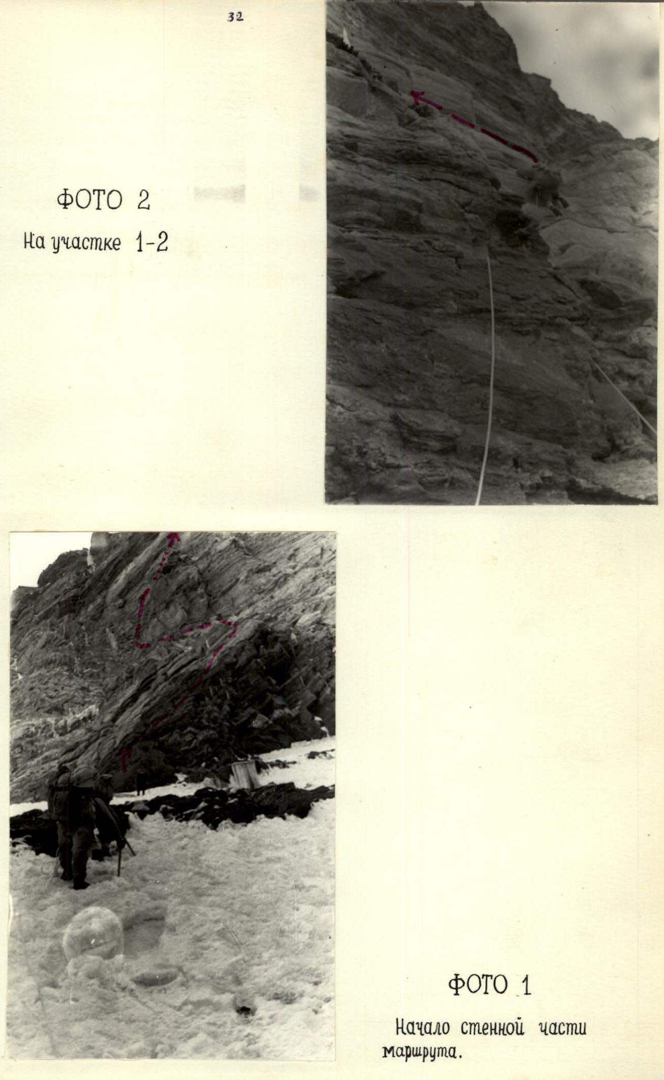
PHOTO 1. Start of the wall section of the route.
PHOTO 4
Yu. Yurgelionis before section R3–R4.
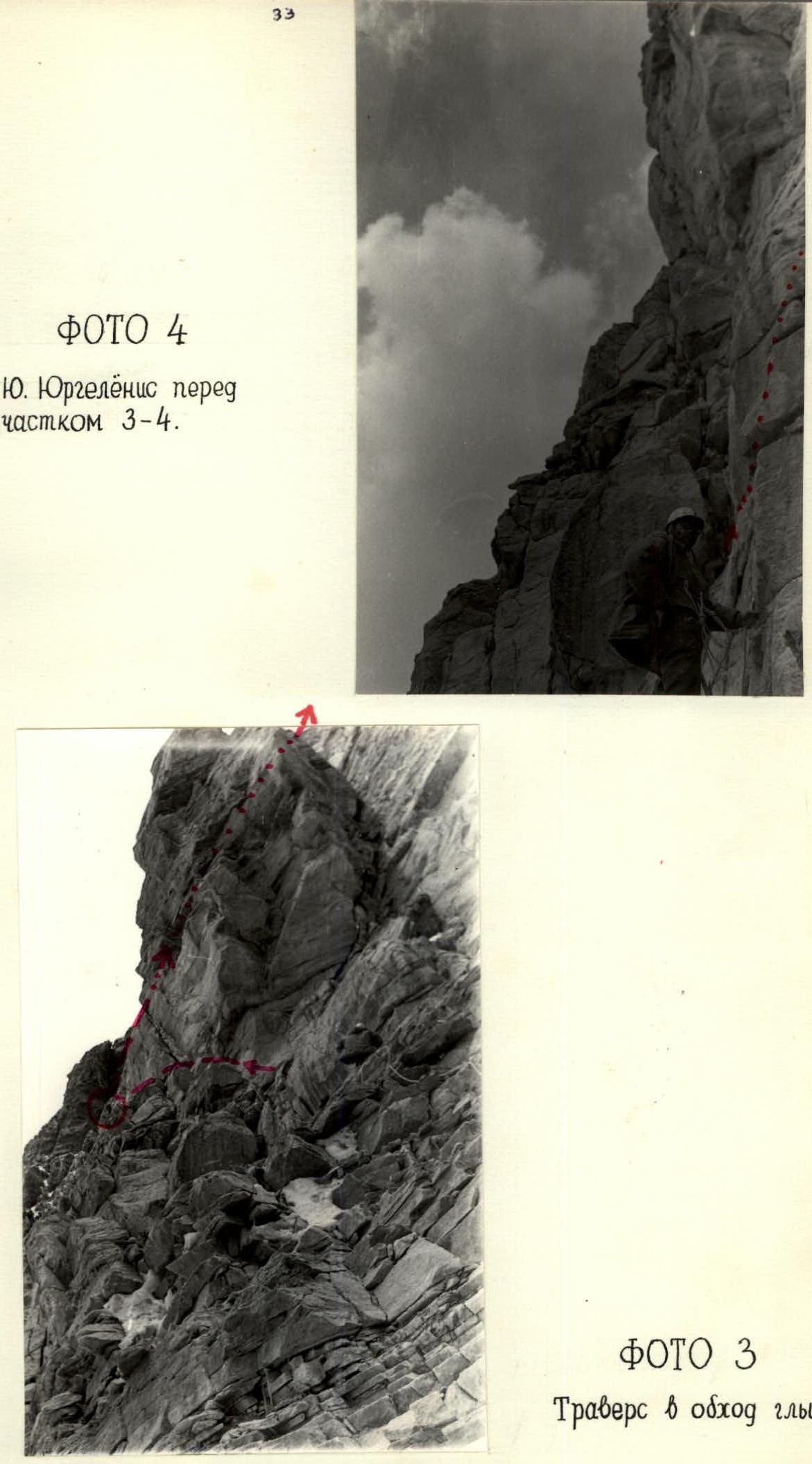
PHOTO 3. Traverse bypassing the boulder.
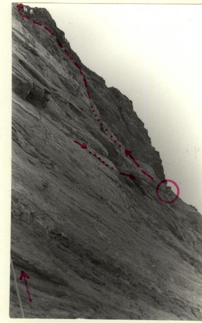
PHOTO 9. Section R13–R15. Approach to "the Organ".
TABLE OF MAIN CHARACTERISTICS OF THE ASCENT ROUTE First ascent to peak LITVA via the fourth bastion
| Date/Day | Sections | Steepness (°) | Length (m) | Characteristics of the section and relief | Category of difficulty | Method of overcoming | Belay | Weather | Departure (h) | Stop (h) | Walking (h) | Rock pitons | Ice, bolt pitons | Buoyancy hooks | Overnight conditions / Notes |
|---|---|---|---|---|---|---|---|---|---|---|---|---|---|---|---|
| 26.07.1974 | R0–R1 | 40–45 | 400 | Snow slope with rocky outcrops and small walls in the upper part | 3 | Simultaneous movement in the upper part with step-making | In the upper part through ledges | Good weather | 7:00 | - | - | - | - | - | - |
| R1–R2 | 60–65 | 90 | Destroyed rocks, ledges | 4 | Ascent climbing, ropes | Ledges, pitons | " | - | - | 2 | 2 | - | - | - | |
| R2–R3 | - | 45 | Narrow, inclined ledges, blocks | 5 | Traverse left, piton securing of ropes | " | " | - | - | 4 | - | - | - | - | |
| R3–R4 | 75–90 | 45 | Destroyed rocks, crack, chimney | 5 | Climbing in the chimney on camming, securing ropes to a ledge, pulling up rucksacks | " | " | - | - | 4 | - | - | - | I control cairn | |
| R4–R5 | - | 25 | Under an overhang | 6 | Traverse left, up, using 1×3 ladders, pulling up rucksacks | " | " | - | - | 7 | - | - | - | - | |
| R5–R6 | 70–80 | 70 | Steep, crumbling rocks, niche, shoulder | 5 | Very cautious climbing, loose rocks, pulling up rucksacks | " | " | 21:00 | - | 14 | 6 | - | - | - | |
| R6 | - | - | Inclined platform | - | Setting up a bivouac platform | Piton belay | Night, wind | - | - | - | - | - | - | Bivouac | |
| 27.07.1974 | R6–R7 | 70 | 110 | Smooth rocks and rocks with detached upper parts | 5 | Vertical ascents alternating with traverses left, first climber in galoshes, difficult selection of cracks for pitons, pulling up rucksacks | Pitons, ledges | Good weather | - | - | 12 | - | - | - | - |
| R7–R8 | 30–40 | 30 | Large talus | 3 | Simultaneous movement of teams | Ledges | " | 9:00 | - | 12 | - | - | - | - | |
| R8–R9 | 75 | 40 | Smooth rocks with an inclined crack | 5 | Ascent along the crack, pulling up rucksacks | Pitons | Good weather | - | 18 | 9 | 4 | - | - | - | |
| R9 | - | - | Ledge with small talus | - | Movement along ropes | Piton belay | Wind | - | - | - | - | - | - | Bivouac, reconnaissance of the route | |
| 28.07.1974 | R9–R10 | 80 | 30 | Smooth wall of hard rock without holds | 6 | Entire passage using ladders, limited selection of cracks | Pitons | Partly cloudy with clearings | 9:00 | - | - | 16 | - | - | Bivouac not dismantled |
| R10–R11 | 85 | 10 | Ledge, internal angle | 6 | Passage using ladders | Pitons | Cloudy, increasing wind | - | - | 6 | - | - | - | - | |
| 29.07.1974 | R11–R9 | - | - | - | - | Descent with étriers, removing some pitons to bivouac 9 | - | Night, wind, snow | - | 18 | 9 | - | - | - | Same |
| R9–R11 | - | - | - | - | Ascent with étriers | - | Cloudy | 17:00 | - | - | - | - | - | Delay at bivouac due to bad weather | |
| R11–R12 | - | 4 | Triangular balcony | 6 | Exit from under the balcony left up with ladders | Pitons | Cloudy | - | - | 5 | - | - | - | - | |
| R12–R9 | - | - | - | - | Descent to bivouac 9 | - | Good weather | - | 20 | 3 | - | - | - | Same, II control cairn | |
| 30.07.1974 | R9–R12 | - | - | - | - | Ascent with étriers, pulling up rucksacks | Pitons | Good weather | 8:00 | - | - | - | - | - | - |
| R12–R13 | - | 9 | Ledges, negative wall, ledge | 5 | Overcoming the wall with ladders, pulling up rucksacks | Pitons | " | - | - | 4 | - | - | - | - | |
| R13–R14 | 70 | 35 | Narrow ledges and blocks | 5 | Climbing right up, pulling up rucksacks | Pitons | " | - | - | 5 | - | - | - | - | |
| R14–R15 | 50–60 | 60 | Destroyed rocks | 5 | Climbing up left | Pitons, ledges | " | - | - | 2 | - | - | - | - | |
| R15–R16 | - | 15 | Negative wall | 6 | Passage with ladders and étriers, pulling up rucksacks | Pitons | " | - | - | 5 | - | - | - | - | |
| R16 | - | - | Terrace | - | Free movement | No need | " | 17:00 | 9 | - | - | - | - | Bivouac, reconnaissance of the route | |
| 31.07.1974 | R16–R17 | 70 | - | Terrace | 2 | Simultaneous movement right | No need | " | 8:30 | - | - | - | - | - | - |
| R17–R18 | 70 | 35 | Negative wall and large slab | 5 | Exit with ladders, further climbing, pulling up rucksacks | Piton belay | " | - | - | 7 | - | - | - | - | |
| R18–R19 | 30–45 | 350 | Snow slope with rocky outcrops and islands | 4 | Step-making, movement along ropes | Pitons, ledges | " | - | - | 8 | - | - | - | - | |
| R19–R20 | - | 500 | Rock-snow ridge, destroyed rocks. Snow sinks deeply | 3 | Traverse to peak Litva, simultaneous movement of teams | Ledges | " | 16:00 | 7:30 | - | - | - | - | Summit of peak LIETUVA | |
| TOTAL ascent: | - | - | - | - | - | - | - | - | - | - | 51.5 | 97 | - | - | - |
| 01.08.1974 | R20–R21 | - | 650 | Snow-rock ridge | - | Descent to the saddle between peaks Litva and Babel, simultaneous movement of teams | Ledges | Good weather | - | - | 2 | - | - | - | - |
| R21–R22 | - | 45 | Steep, icy rocks | - | Rappel | Pitons | " | - | - | 4 | - | - | - | - | |
| R22–R23 | 70 | 47 | Snow couloir | - | Sport descent | Pitons | " | - | - | 3 | - | - | - | - | |
| R23–R24 | 50–40 | - | Snow couloir | - | Simultaneous descent | No need | " | - | - | - | - | - | - | - | |
| R24–R0 | 30 | - | Rock-snow slope | - | Simultaneous descent-traversing | No need | " | 19:30 | - | - | - | - | - | - | |
| TOTAL descent: | - | - | - | - | - | - | - | - | - | - | 9 | - | - | - | - |
Group leader: Z. Blažaitis