
Ascent Passport for Litva Peak (6080 m)
- Climbing category: High-altitude technical climb
- Climbing area: South-West Pamir, Shakhdařinskij Ridge, Litva Peak (6080 m).
- Climbing route with indication of peaks and their elevations: Litva Peak (6080 m); first ascent via the western wall, category 5B difficulty, 5th bastion.
- Climbing characteristics:
- Elevation gain: from camps under the wall at 5200 m to the summit at 6080 m, with an elevation gain of 880 m;
- Average steepness: wall section of the route is 65–70°;
- Length of the complex section of the route: wall section is 500 m.
- Number of pitons driven:
- Rock pitons: 71
- Bolt pitons: 3
- Ice pitons: 4 (on descent).
- Number of climbing hours: 34
- Number of bivouacs and their characteristics:
- Bivouac under the wall.
- Bivouac on the wall on a ledge under overhanging rocks.
- On the wall under the pre-summit rocky bastion.
- Team name: Team of Dnipropetrovsk Regional Council of the "Burevestnik" Sports Club.
- Surname, initials of the team leader, participants, and their qualifications: Orlov O.L. — CMS — team leader; Kazak L.R. — MS — participant; Zyuzin V.S. — CMS — participant; Axelrod E.L. — CMS — participant; Chekanov V.P. — 1st sports category — participant; Belimenko G.A. — 1st sports category — participant.
- Team coach: Master of Sports of the USSR, senior instructor Saprykin V.D.
- Date of departure and return:
- 11.07 — departure from the base camp;
- 14.07 — descent to the bivouacs under Litva Peak.

2. Brief geographical description of the area
Litva Peak (6080 m) is located in the Shakhdařinskij Ridge of the South-West Pamir. In the Kishty-Dzherob valley, Litva Peak is cut off by steep walls. Despite its remote location, the mountains of the South-West Pamir are well-known and relatively well-explored for alpinism. This is due to the presence of good transportation routes and high, beautiful mountains with many complex routes of 5th and 6th category difficulty.
The most famous peaks in this area are:
- K. Marx Peak (6726 m)
- Engels Peak (6510 m)
- Tajikistan Peak (6565 m)
- Moskovskoi Pravdy Peak (6075 m)
- Litva Peak (6080 m)
- and several others.
Climatic features of the area include prolonged periods of stable weather without significant precipitation. However, in the 1978 season, an unusually long period of precipitation was observed, significantly increasing rockfall hazards in the area.
3. Map of the climbing area
Below is a scale-less map of the area with the approach route, ascent, and descent from Litva Peak.
The map also indicates the Isor village, which can be reached by car.
4. Climbing conditions in the South-West Pamir area
To the upper reaches of the Kishty-Dzherob valley, where it is convenient to establish a base camp, goods can be transported from Isor village using pack animals.
Climatic features of the area include:
- sharp daily temperature fluctuations,
- increased rockfall hazards.
5. Description of the route by days with a brief characteristic of the path traveled
July 11, 1978
From the base camp, located three kilometers from the tongue of the Kishty-Dzherob glacier, the group departed at 10:00 and followed the trail (right bank) for 1.5 hours to reach the tongue of the Kishty-Dzherob glacier. Here, in the early hours of the day, it is possible to cross to the left bank via the rocks. Then, continue along the trail to a stream that flows into the Kishty-Dzherob river from the left and originates under the slopes of Babel and Litva peaks.
Follow the trail along this stream to ascend to the left lateral moraine and approach the upper bivouacs located under the western wall of Litva Peak. From the base camp to the bivouacs — 8 hours.
July 12, 1978
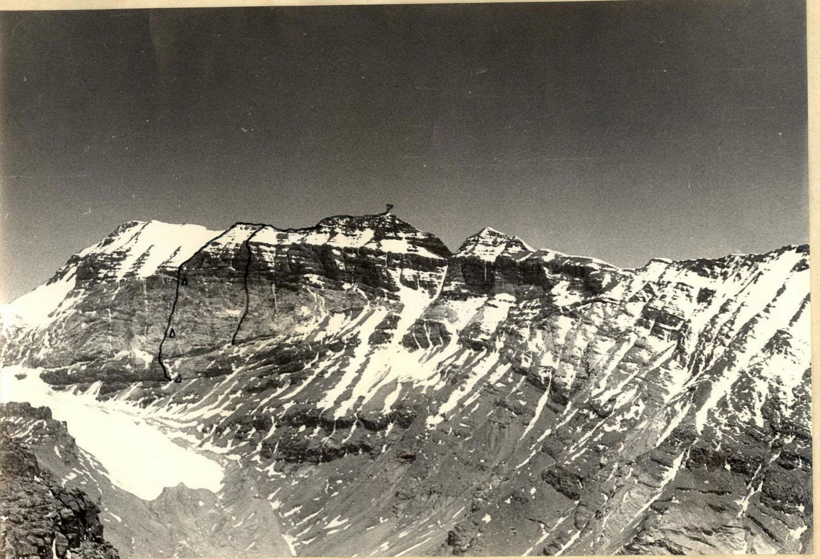
From the bivouacs, all routes on the Western wall are clearly visible. The starting point of the chosen route on Litva Peak is the "nose" — a protrusion of the wall ending in a 40-meter sheer drop (photo 2).
Departure from the bivouacs at 8:00. After 1.5 hours, gaining altitude with a traverse towards the "nose," we approach the first critical section.
Further, there is a rope section of difficult climbing:
- 15 m — rocks
- 10–15 m — slab-like rocks
- then a narrow crevice leading to the top of the protrusion.
Piton protection, rope hauling.
Sections R1–R2 — category 5 difficulty.
Approaching the wall, the route goes up an internal angle (20 m) ending in a cork, with an exit to a narrow ledge (rope hauling). Then, a traverse to the left (20 m) along the ledge and further up (80 m) of difficult climbing on slab-like layered rocks (photo 3) — sections R2–R3 (category 5 difficulty). The slabs end with a small ledge, from which the key section of the route begins.
On the ledge, we managed to set up two tent platforms (photo 7). To the left of the bivouac is a couloir with ice. The wall is dry. Water is available in the form of ice and snow.
July 13, 1978
Departure at 8:30. The weather is clear, but very cold. Directly above the platform is an overhanging cornice, which is bypassed to the right via very complex rocks using artificial supports and driving bolt pitons (35 m) — photo 8. Rocks are of the "sheep's forehead" type with a small number of cracks. Section R3–R4 (category 5–6 difficulty). The rope ends on a narrow inclined ledge, where the entire group gathers, and receives the backpacks (photo 9).
Further, the path goes along complex rocks — an oblique traverse to the right (photo 10) — four ropes (section R4–R5) under the rusty wall, which is clearly visible from a distance. The rusty wall is climbed via a crevice and two slopes. Tense climbing. Rope hauling — sections R5–R6 (category 5 difficulty) — photo 11 (Control tour!).
Further, the wall noticeably becomes less steep, and five ropes of medium-difficulty rocks lead under the pre-summit rocky bastion. Bivouac (photo 4). A very convenient place for a bivouac. 2 hours of working time.
July 14, 1978
Departure at 8:00. The pre-summit bastion is just over two ropes high. Climbing is complex. Monolith. Rope hauling (photo 12). Further movement follows the rocky ridge, leading to the summit. From the bivouac, 5.5 hours.
More detailed information is provided in the table of main route characteristics.
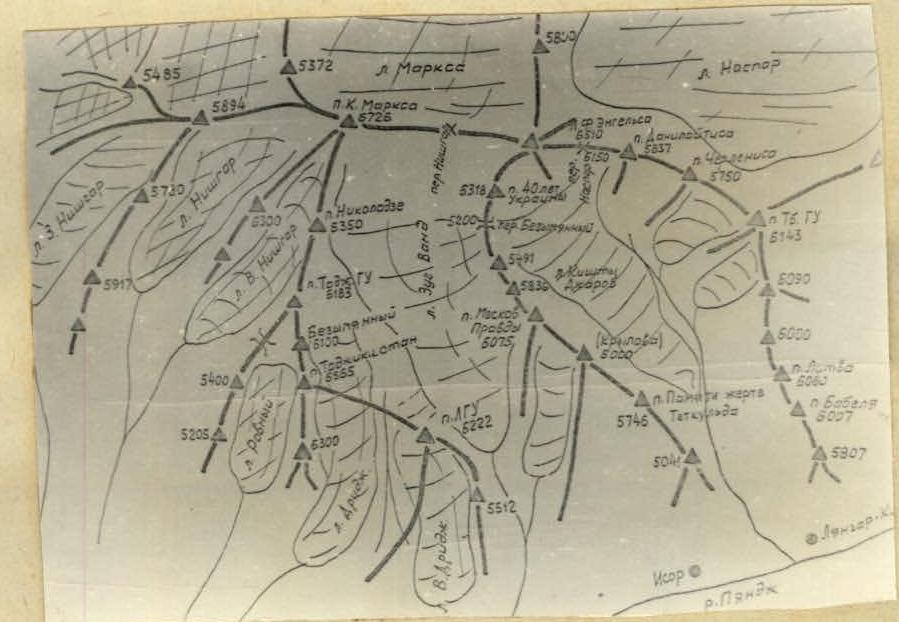
Table of main route characteristics
| Section | Steepness | Length (m) | Terrain characteristics | Difficulty | Condition | Weather conditions | Rock pitons | Bolt pitons | Ice pitons | Notes |
|---|---|---|---|---|---|---|---|---|---|---|
| R0–R1 | Destroyed rocks | 2–3 | Live rocks | good | – | – | – | |||
| R1–R2 | 80° | 40 m | Rocks | 5 | Clean rocks | good | 7 | – | – | |
| R2–R3 | 75–80° | 80 m | Rocks | 5 | Some live rocks | good | 10 | – | – | |
| R3–R4 | 80° | 35 m | Rocks | 5–6 | Clean rocks | good | 9 | 3 | – | |
| R4–R5 | 60° | 160 m | Rocks | 4 | Many ledges and cracks | good | 9 | – | – | |
| R5–R6 | 80–85° | 40 m | Sheer rocks | 5 | Live rocks | good | 7 | – | – | |
| R6–R7 | 50–55° | 200 m | Severely destroyed part of the wall | 3 | Many live rocks. Verbal ice | good | 13 | – | – | |
| R7–R8 | 80–85° | 90 m | Monolith | 5 | Some verbal ice | good | 11 | – | – | |
| R8–R9 | 45–50° | 200 m | Snow-rock ridge | 3 | good | 5 | – | – |
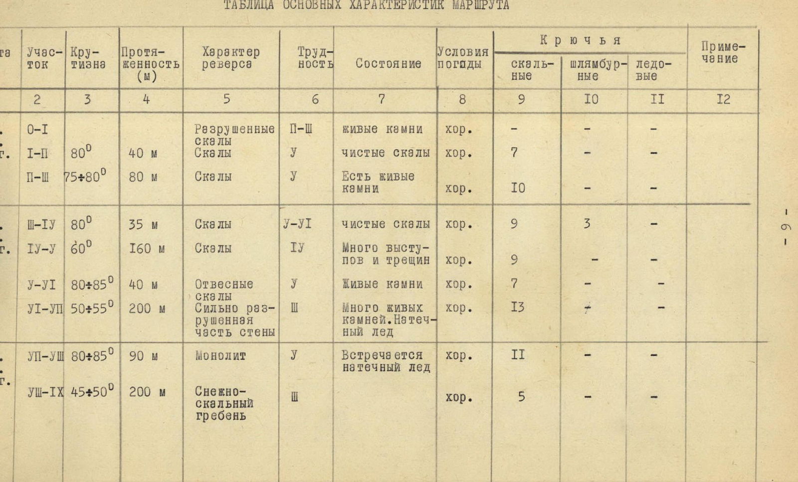
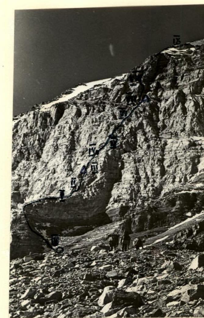
Photo — general view of the wall. The "nose" — the starting point of the route — is clearly visible.

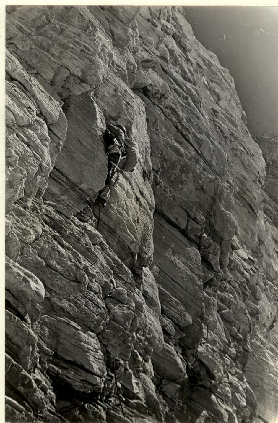
Photo — overhanging rocks of section R2–R3.
Footnotes
-
Classification of difficulty is based on the methodology proposed in the book by A.F. Naumov "Karagom, Digoria, Tsey". Moscow, "Fizkultura i sport", 1976. ↩