
ASCENT DOCUMENT
- Ascent class — high-altitude and technical
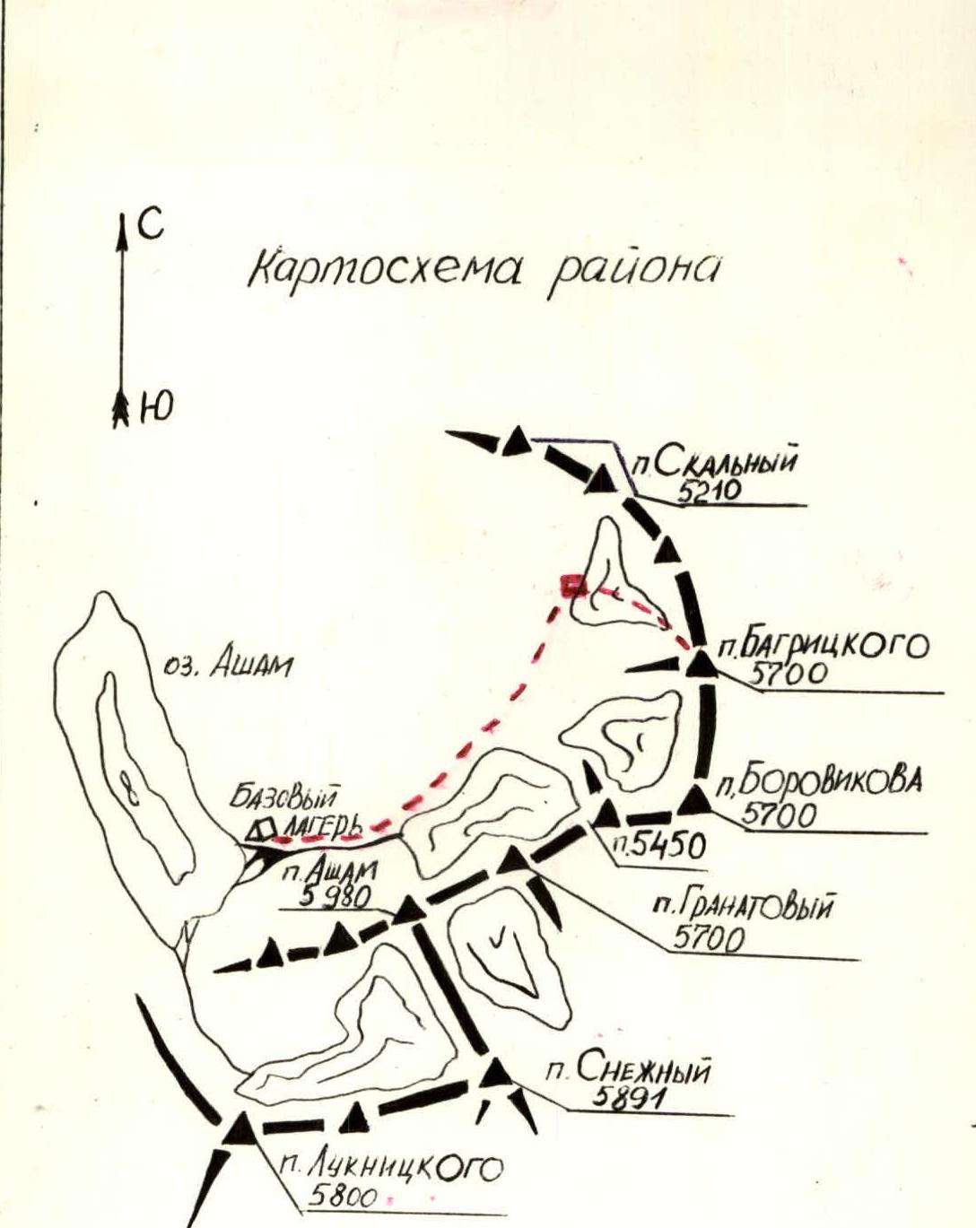
- Ascent area — Shakhdarin Range, southwestern Pamir.
- Peak, its height, and ascent route — Pik Bagritskogo, 5700 m, via the southwest wall with exit to the summit along the northwest counterfort.
- Proposed difficulty category — 4Bk/tr.
- Route characteristics: elevation gain — 1100 m average steepness — 58°; rocks — 69°; ice — 48°. Length of sections: R1 — 80 m, R2 — 290 m, R3 — 215 m, R4 — 385 m, R5 — 180 m.
- Pitons driven: for belaying — 55, for creating belay stations — 1, rock — 43, ice — 10, chocks — 3
- Number of climbing hours — 21
- Number and characteristics of bivouacs — 1 bivouac on a rock ledge, normal.
- Surname, name, patronymic of the leader and participants, their sports qualification.
Leader — TIKHONKOVA NATALYA ARKADYEVNA — 2nd sports category, instructor
Participants:
- SOMOV YURY VLADIMIROVICH — 1st sports category, instructor
- YANCHENKOV VIKTOR FEDOROVICH — 1st sports category
- KHOLOPTSEV ALEKSANDR VADIMOVICH — 2nd sports category
- SHAMRAKOV BORIS EFIMOVICH — 2nd sports category
- SITNIK MIKHAIL ALEKSANDROVICH — 2nd sports category
- Team coach — SVIRIDENKO VADIM SERGEEVICH — Master of Sports
- Date of departure for the route and return — July 5 — July 6, 1977
1. Brief description of the approach to the route
Pik Bagritskogo (5700 m) is located in the Shakhdarin Range. The vehicular part of the journey ends in the village of Sevd, situated on the road that runs along the Shakhdara River. It is possible to travel through Roshtkala from Khorog and from the Pamir Highway Osh — Khorog via Djilandy — Sovetabad.
From the village of Sevd to the expedition's base camp leads a convenient pedestrian and caravan trail, as this is a grazing area. The trail goes along the left (orographic) side of the Asham River, which gives its name to the entire area. From the village of Sevd to a suitable location for the base camp in a small grove on the lake shore — 5–6 hours, elevation — 3700 m.
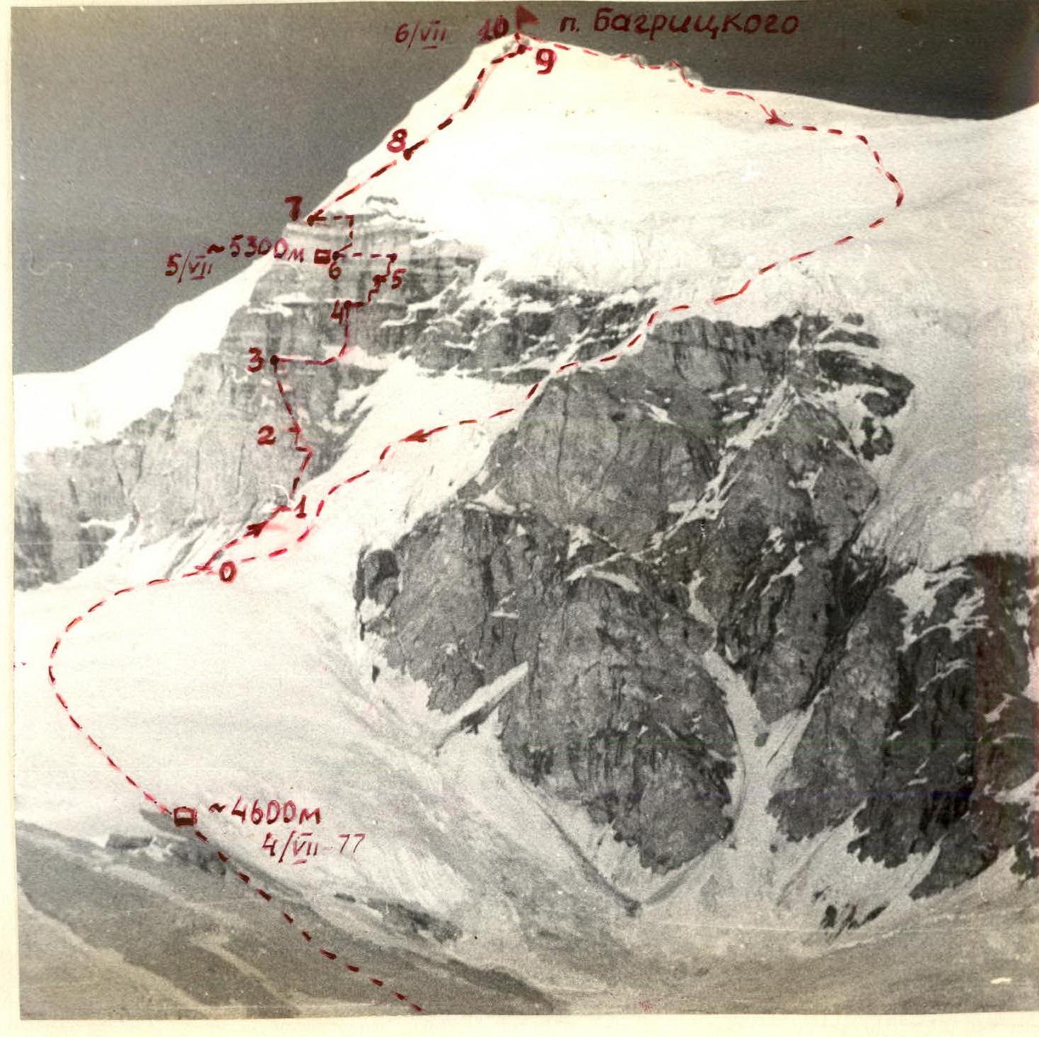
From the base camp by the Asham lake, along the right (orographic) bank of the river, up to its source (2 hours) and further along the right-bank lateral moraine, ascent to the unnamed glacier below Pik Bagritskogo (3 hours). The bivouac elevation — 4600 m. The bivouac is normal.
2. Ascent tactics
The tactical plan for the ascent provided for the following sequence of route passage:
- first day — departure from the base camp, approach to the route, observation and reconnaissance of the route, bivouac;
- second day — start on the route, passage of the west wall, bivouac;
- third day — passage of the snow and ice part of the summit via the northwest counterfort, exit to the summit, selection of a descent variant and descent, bivouac;
- fourth day — return to the base camp by Asham lake.
To ensure safety, 2 interacting groups were positioned on parallel routes.
Table №1
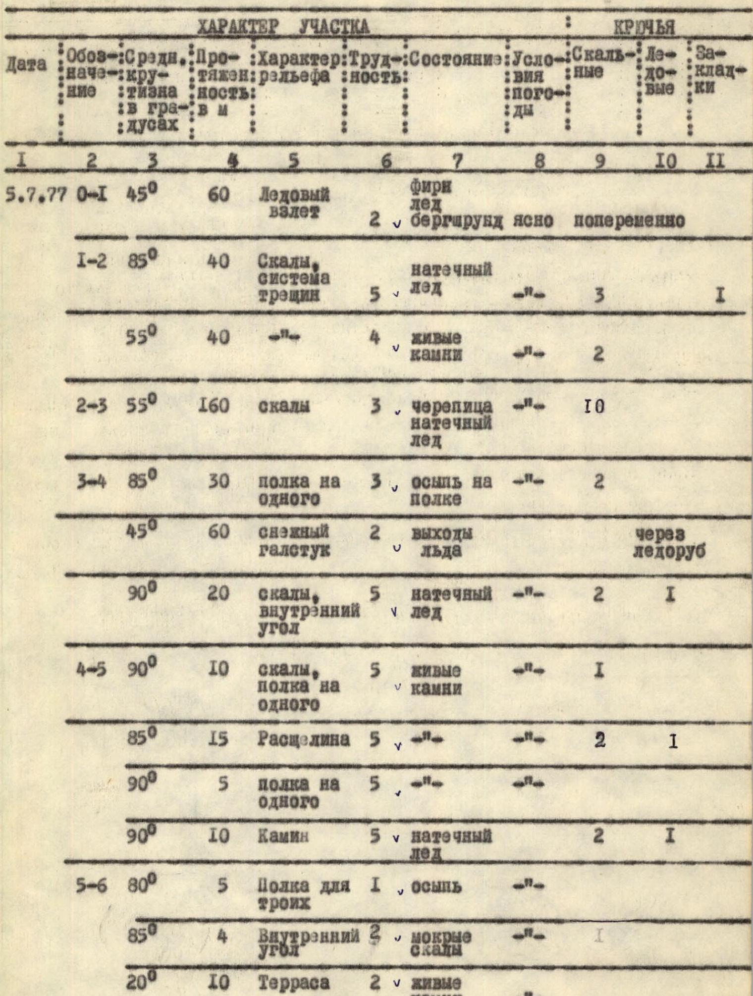
| № | Date | Section | Steepness (°) | Length (m) | Terrain characteristics | Difficulty | Condition | Weather conditions | Rock pitons | Ice pitons | Chocks |
|---|---|---|---|---|---|---|---|---|---|---|---|
| July 5, 1977 | R0–R1 | 45° | 60 m | Ice ascent | 2 | Firn, ice | clear | alternately | |||
| R1–R2 | 85° | 40 m | Rocks, system of cracks | 5 | ice coating | 3 | 1 | ||||
| 55° | 40 m | loose rocks | 4 | 2 | |||||||
| R2–R3 | 55° | 160 m | Rocks | 3 | tiles, ice coating | 10 | |||||
| R3–R4 | 85° | 30 m | Ledge for one | 3 | scree on the ledge | 2 | |||||
| 45° | 60 m | Snow "necktie" | 2 | ice outcrops | via ice axe | ||||||
| 90° | 20 m | Rocks, inner corner | 5 | ice coating | 2 | 1 | |||||
| R4–R5 | 90° | 10 m | Rocks, ledge for one | 5 | loose rocks | 1 | |||||
| 85° | 15 m | Crevice | 5 | 2 | 1 | ||||||
| 90° | 5 m | Ledge for one | 5 | ||||||||
| 90° | 10 m | Chimney | 5 | ice coating | 2 | 1 | |||||
| R5–R6 | 80° | 5 m | Ledge for three | 1 | scree | ||||||
| 85° | 4 m | Inner corner | 3 | wet rocks | 1 | ||||||
| 20° | 10 m | Terrace | 2 | loose rocks | |||||||
| R5–R6 | 90° | 10 m | Inner corner | 5 | loose rocks | clear | 3 | ||||
| 90° | 2 m | Ledge for three | 2 | monolith | |||||||
| 90° | 10 m | Rocks, crevice | 5 | 2 | |||||||
| 80° | 10 m | Rocks, wall | 5 | 3 | ladders | ||||||
| 90° | 15 m | Small ledge for one with expansion | 5 | water | 4 | ||||||
| July 6, 1977 | R6–R7 | 60° | 25 m | Rocks, inner corner | 3 | ice coating | clear | 2 | |||
| 85° | 10 m | 5 | 2 | 1 | |||||||
| 85° | 1 m | Ledge for two | 3 | ||||||||
| 85° | 15 m | Rocks, inner corner | 5 | ice coating | 3 | 1 | |||||
| 90° | 20 m | Ledge for four | 1 | scree | simultaneously | ||||||
| R7–R8 | 35° | 80 m | Snow counterfort | 2 | firn | alternately via ice axe | |||||
| 70° | 3 m | Ice wall | 3 | ice coating | alternately via ice axe | ||||||
| 35° | 80 m | Snow slope | 2 | firn | simultaneously | ||||||
| R8–R9 | 45° | 300 m | Ice slope | 4 | ice coating, rock outcrops | 5 | rock outcrops | ||||
| 70° | 8 m | Ice wall | 5 | ice coating | 2 | ||||||
| R9–R10 | 30° | 60 m | Snow ridge leading to the summit | 1 | loose snow | simultaneously |
Departure from the bivouac at 6:00. Stop for bivouac at 18:00. 11 climbing hours. Bivouac on a rock ledge, normal. July 6, 1977.