Description
FIRST ASCENT TO THE SUMMIT 6007 M via the south-west wall (South-Western Pamir) (Peak I. Babel, Odessa, 1967)
Brief geological and geographical characteristics of the area
The mighty Pyanj River has carved a deep valley in the rocks, dividing two mountain systems: — Pamir — Hindu Kush
Flowing in a winding course, it runs along the Shakhdarin Range — the southern boundary of Pamir, as if skirting it from the south.
The Shakhdarin Range stretches for 350 km from southwest to northeast, reaching its highest heights with peaks Karl Marx — 6726 m and Engels — 6310 m, located near the confluence of the Vakhsh-Darya River and Pyanj.
The peaks of Marx and Engels form a powerful mountain node with a fairly large area of glaciation — about 140 sq. km.
One of the most significant glaciers descending from the southern slopes of the Engels massif is the Kishty-Dzherob glacier, which lies in a huge bowl, bordered on three sides by a palisade of peaks rising above the glacier by 1500–2500 meters.
Along the left side of the glacier to the southeast of p. Engels stretches a ridge with a number of peaks reaching a height of over 6000 m. The highest point of this ridge is p. Litvy 6090 m, to the right of which, after a deep failure, stands the summit 6007 m — the goal of our ascent.
Like most peaks in this area, peak 6007 m has a blocky structure of rocks composed of various fine-grained granite rocks, resting on a granite base, as a result of which the walls of the peak are extremely steep sections.
Choice of ascent route
In recent years, the team of the Odessa Regional Council of the "Avangard" Sports Society has successfully performed in the championship of the Ukrainian SSR in the class of technically complex traverses and high-altitude ascents.
1961 — champions of Ukraine in the class of technically complex ascents for the first ascent to v. Bashkara via the northern wall 5B.
1962 — champions of Ukraine in the class of traverses for the traverse of the Shkhelda massif.
1963 — 2nd place in Ukraine in technically complex routes for the ascent to p. Volnaya.
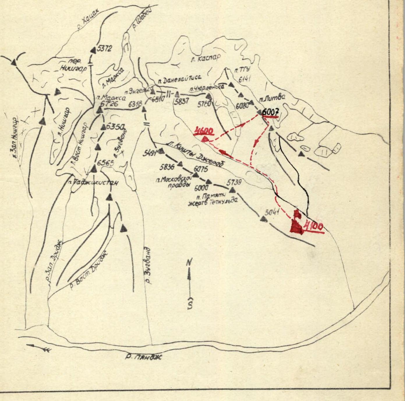 Orographic scheme of the Shakhdarin Range in the area of peaks Engels and Marx
1964 — champions of Ukraine in the class of traverses for the traverse of the Chatyr-Tau — Ushba massifs from northeast to southwest and 1st place CS DSO "Avangard" in the class of technically complex routes for the first ascent to v. Dolra via the northern wall.
1965 — champions of Ukraine in the class of traverses and high-altitude ascents: traverse of the Ak-Sai semi-horseshoe, ascent to p. Lenin from the north.
1966 — champions of Ukraine in the class of technically complex: first ascent to v. Chatyn via the "triangle" and champion of the Central Committee of DSO "Avangard" for the traverse of the Shkhelda massif.
The team has acquired and accumulated a wealth of experience in first ascents of technically complex routes of great length.
On the first trip to the Kishty-Dzherob glacier, the team's attention was drawn to the southwest wall of peak 6007 m, the spectacular view of which opens from any observation point located on the glacier.
The first ascent of the southwest wall of v. 6007 m was of interest to the team for several reasons:
- A long wall combined route of the highest category of complexity to a peak above 6000 m.
- The logic and straightforwardness of the route along the wall, which is a three-belt system of rock shell structures made of fine-grained granite, separated by narrow snow shelves.
- The passage of the planned route would make a significant contribution to the development of the area.
- Training for the main ascent to v. p. Engels from the north via the route of the CSKA team.
Composition of the sports group
To participate in the competitions of the Central Committee of the DSO "Avangard" and the championship of Ukraine for the best ascents of the 1967 season in the class of technically complex ascents, a team of climbers from the Odessa Regional Council of the DSO "Avangard" was entered. The main group consisted of:
— Master of Sports Lifshits V. Ya., — Master of Sports Fedchenko V. P., — Master of Sports Vaisberg E. M., — Master of Sports Sviridenko V. S., — CMS Simonenko V. K., — 1st sports category Mogilevsky Yu. I., — 1st sports category Zimnitsky E. P., — 1st sports category Popov A. V., — 1st sports category Shatilov V. M., — 1st sports category Levitsky E. M. and — 1st sports category Melnik V. I., — 1st sports category Ivanov A. I., — 1st sports category Yaroshenko V. N.
This composition was submitted in the application to participate in the competition for the best ascent of the Central Committee of the DSO "Avangard" and Ukraine. The final composition of the group for the ascent was selected with great care in the amount of 5 people. Although the task of the final composition of the team was somewhat facilitated by the fact that:
— all team members have known each other for a long time, — together they have made several ascents of the highest category of complexity, but it was not an easy task.
After the final approval by the coaching council, the team was presented in the following composition:
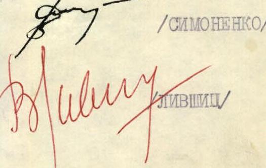
Simonenko Valentin Konstantinovich — group leader. Born in 1940, CMS, mountaineering experience since 1960. 9 ascents of 5 cat. complexity, trainee. Home address: Odessa-18, Mira St., 25/51.
Lifshits Viktor Yakovlevich — senior coach of the team. Born in 1928, Honored Master of Sports, mountaineering experience since 1947. 22 ascents of 5th cat. complexity. Senior mountaineering instructor. Home address: Odessa, Sovetskoy Armii St., 1, apt. 2.
Sviridenko Vadim Sergeevich — born in 1937, Master of Sports, mountaineering experience since 1956. 12 ascents of 5th cat. complexity. Mountaineering instructor. Home address: Odessa, Kosmonavtov St., 84, apt. 59.
Vaisberg Eduard Mironovich — born in 1934. Master of Sports, mountaineering experience since 1952. 14 ascents of the highest category of complexity. Mountaineering instructor. Home address: Odessa, Frantsa Meringa St., 1, apt. 9.
Fedchenko Vladimir Petrovich — born in 1935, Master of Sports, mountaineering experience since 1952. 16 ascents of 5th cat. complexity. Home address: Odessa, Chkalova St., 10/16. As the ascent showed, the number of participants in the group of 5 people on this ascent is optimal.
Technical skill, excellent physical fitness and good acclimatization allowed all team members to be in excellent form during the first ascent.
Tactical plan for the first ascent
Guided by the data of reconnaissance of peak 6007 m, consultations received from comrades familiar with this area, as well as information available in the literature, the following tactical plan for the first ascent was developed.
The ascent should be made from a base camp located as close as possible to the foot of the wall, equipped with equipment and supplies necessary for the assault and reconnaissance trips to finally clarify the route. Such a camp became the camp "4600", located in the pocket of the left, orographic moraine of the Kishty-Dzherob glacier. To observe and communicate, a group was allocated consisting of:
— Volkats B. M. — leader — Nelupov V. A. — participant — Korolev V. A. — participant — Perekrestov V. I. — participant
which was to monitor the assault team until it reached the summit.
The plan provided for the gathering of the main and auxiliary groups in the base camp "4600" after the completion of the first ascent.
After a thorough examination of the entire wall, the locations of the overnight stays were marked. At the first stage of the movement, the rope teams were distributed as follows:
— Sviridenko — Lifshits — Simonenko — Vaisberg — Fedchenko
During the subsequent movement, the leading rope teams changed several times, and this did not slow down the pace of movement.
The first person in the group, as a rule, went with a lightened or completely without a backpack.
Due to the complexity of the route and to ensure 100% safety, a significant part of it was passed using the rope of the previous team — the leader of the subsequent team.
On less complex sections, the first team left behind hooks and suspended carabiners for the subsequent team.
A detailed list of products and equipment taken on the route is given in the appendix.
Description of the route passage
July 12, 1967
From the base camp "4600" we move towards the southwest wall of peak 6007. At the foot of the wall at an altitude of 4900 m we stop for the night, process the lower part of the route and hang 2 ropes.
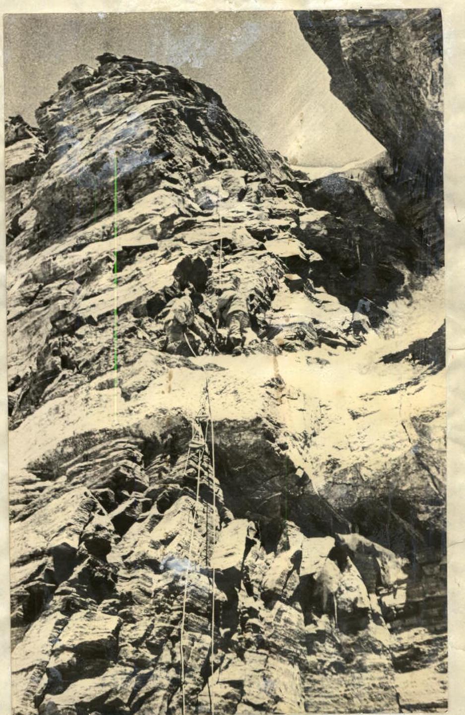
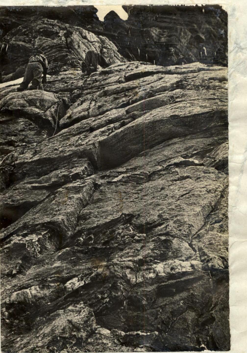
July 13, 1967. At 7:00 we start moving (see photo).
Section R0–R1. Using the hung ropes, we begin to climb the steep snow-ice couloir cutting through the first block of the wall. The snow cover is very unstable, it is difficult to walk, the average thickness of the snow cover is 20 cm, the underlying layer for snow is ice. The steps made yesterday by the double team help a lot. The average steepness of the couloir is 55°, the length is 80 m, 2 rock and 2 ice hooks are hammered.
Section R1–R2. The couloir leads to the base of a steep snow slope with two rock islands. Movement in the direction of the first rock island. The average steepness of the slope is 55–60°, insurance through an ice axe and rock hooks. The movement is alternate. The length of the route is 120 m. 2 rock hooks are hammered.
Passage of the section
| Section | |
|---|---|
| R2–R3 | From the first rock island further up the snow slope of average steepness 60°, to the second rock island. The movement is alternate. Insurance through an ice axe. The length of the route is 120 m. 1 rock hook is hammered. |
| R3–R4 | The direction of movement is to the right to the base of the destroyed rock wall of black color. First, 20 m along the snow with a steepness of up to 60°, then 10 m along a gentle couloir filled with atonic ice with a steepness of 50°. We approach a heavily destroyed wall filled with atonic ice. The steepness of the wall is 50°, the length is 15 m. DIFFICULT PLACE!!! Total length of the section — 45 m. Average steepness — 55°: alternate movement, hook insurance. 3 ice hooks, 5 rock hooks are hammered. |
| R4–R5 | Along a steep inclined shelf 0.3–0.35 m wide we move to the right. The entire shelf is covered with separate stones, covered with snow and partially filled with atonic ice, the length of the shelf is 30 m, the average steepness is 45–50°. DIFFICULT PLACE!!! The shelf leads to a small rock wall 10 m high with a steepness of 65°. Having overcome the wall, we find ourselves on a narrow terrace, where we make the first control belay. The total length of the section is 40 m, 7 rock hooks are hammered, the average steepness is 60°. |
| R5–R6 | From the control belay to the left along a narrow shelf 5 m and then up a narrow crack with a steepness of up to 70°, the length of the crack is 5 m. The crack is clogged with a stone from above. VERY DIFFICULT PLACE!!! CAREFUL HOOK INSURANCE, MOVEMENT WITHOUT BACKPACKS! Further up the rock wall with destroyed rocks of average steepness 65°, covered with snow and partially filled with ice. The total length of the section is 60 m, the average steepness is 65°, hook insurance. 6 rock hooks and 1 ice hook are hammered. |
16:30 — the passage of the last section leads to a narrow terrace at an altitude of 5400 m, where after 1 hour 30 minutes of work a place for a tent was cut out. At the same time, we work on clearing the area, the double team processed the route.
The overnight stay was located at the top of the dark belt of rocks under the wall of grey color (see photo).
July 14, 1967
Departure from the bivouac at 7:30. We begin to pass the lower block of the second rock belt of the southwest wall of peak 6007 m. From the overnight site along a horizontal snow shelf we move to the right to the place where the grey wall is supported by a not clearly expressed steep rock counterfort. Movement along the shelf: alternate, hook insurance, we hammer hooks into the grey wall. The length of the section is 40 m, 2 hooks are hammered.
Section R7–R8. We pass the grey wall up along a not clearly expressed rock counterfort with a total steepness of 75°, cut by two narrow horizontal shelves into equal height sections. The rocks are very fragile, have a tile-like structure, ordinary hooks do not hold in the cracks, we use elongated hooks — "French" type, ice titanium hooks and wooden wedges. The ascent is very slow, the height begins to affect with such intense rock work. DIFFICULT PLACE!!! The length of the section is 60 m, 8 hooks are hammered.
Section R8–R9. Further, the path goes up to the left along a snow-ice slope with a steepness of 60°, interrupted by a number (three) of sheer rock walls 3–4 m high under huge inclined grey slabs. The length of the section is 40 m, the average steepness is 65°, 6 rock and 1 ice hook are hammered.
Section R9–R10. We pass the slabs straight up along a not clearly expressed narrow crack. They represent a plane of rock breakage and are devoid of any footholds, the only crack is the only place where you can hammer hooks (drill hooks do not hold). Very difficult place. The entire ascent along the slabs was made without backpacks, we pull the backpacks up. The ascent straight up leads to a narrow shelf of overhanging black stone. The overhanging black stone, to which the passage of the slabs led, serves as a kind of black cornice of the grey wall. The grey wall is passed. The total length of the route is 40 m, the average steepness is 60°, 6 hooks are hammered.
Section R10–R11. We pass under the overhanging black stone from right to left and move further up along not clearly expressed shelves covered with snow and filled with ice, interrupted by a number of sheer and overhanging walls 4–5 m high, to a wide balcony under a sheer 40-meter wall. The entire path to the wall is made with careful hook insurance, despite the fact that throughout the entire section it is necessary to chip ice from the rocks to hammer the hooks. The length of the section is 60 m, the total steepness is 60°, 5 rock and 2 ice hooks are hammered.
Section R11–R12. After a series of failed attempts to pass the wall on the left along the course (on the right — a break), we begin to climb the middle of the wall straight up. The rocks are "smoothed" with microscopic footholds for fingertips, the top of the wall — the last 2–3 m — overhangs. The wall is a huge block of fine-grained granite, so even the smallest foothold is a solid support. We use the entire arsenal of technical means and skills. The first person passes the wall on a double rope without a backpack, leaving behind hammered hooks with ladders. VERY DIFFICULT PLACE!!! The length of the wall is 40 m, 12 hooks are hammered. Steepness 80°.
Passage of section R11–R12.
Section R12–R13. Further, the path goes along a steep rock ridge, heavily destroyed, covered with snow and partially filled with ice. Movement along the ridge is a series of rock walls 5–6 m high and snow bridges between them. The movement along the ridge leads to the base of the bastion — the third belt of the wall, where on a shelf covered with snow we find an excellent place for an overnight stay — height 5650 m. The length of the section is 80 m, the average steepness is 60°, 8 hooks are hammered.
July 15, 1967
The planned early departure is delayed due to a late stop for the night at 19:30, and most of all — due to the labor-intensive complex work at such a height.
Fatigue is felt, we want to quickly pass the last one of the most difficult obstacles on the way to the summit — the pre-summit bastion, the third rock belt. We leave the overnight site at 8:00.
Section R13–R14. We pass the bastion to the right along the course. First, the ascent goes along a not clearly expressed rock shelf with a steepness of up to 70°, filled with atonic ice and interrupted by a number of sheer walls 3–4 m high. The movement along the shelf leads to a narrow groove with "smoothed" rocks with a steepness of up to 60°, partially filled with atonic ice. We move up the groove 8–10 m and, not reaching the end, we begin to climb straight up along the left wall along the course. DIFFICULT PLACE!!! During the movement, careful hook insurance is used all the time, and some sections are passed "by pulling". The length of the section is 65 m. 7 hooks are hammered.
Section R14–R15. The movement goes straight up the wall in the direction of a not clearly expressed shelf covered with snow, under a huge granite slab of grey color. The wall is composed of granites, clean of snow and ice. The rocks are strong, with a sufficient number of footholds. We pass the wall with careful hook insurance. The length of the route is 60 m, the total steepness is 80°, 9 hooks are hammered.
Section R15–R16. From the snow shelf, under the last step of the pre-summit counterfort, we traverse to the left along a horizontal groove, which rests against the outer rock angle with an overhanging upper part. The total overhang is 1.5 m. We pass the entire section without backpacks on a double rope with pulling. Very difficult place. The length of the section is 40 m, the average steepness is 90°.
7 rock hooks are hammered. Section R16–R17. Further up along a narrow rock couloir filled with atonic ice. The total steepness of the couloir is interrupted by three rock walls 3 m high with a steepness of 90°. The length of the section is 40 m, the total steepness is 70°, 4 rock hooks are hammered.
Section R17–R18. The further ascent goes along a snow slope with rock outcrops, which leads at 17:30 to the summit. The altimeter reads 6007 m.
The total length of the section is 220 m. The steepness of the slope is 60°, insurance through an ice axe and hooks, 3 rock hooks are hammered.
The descent from the summit first goes along the ridge in the direction of peak 5800 m, and then, not reaching its summit 10–12 ropes, we descend along a snow couloir to the Kish—Dzherob glacier. The entire descent takes 10 hours.
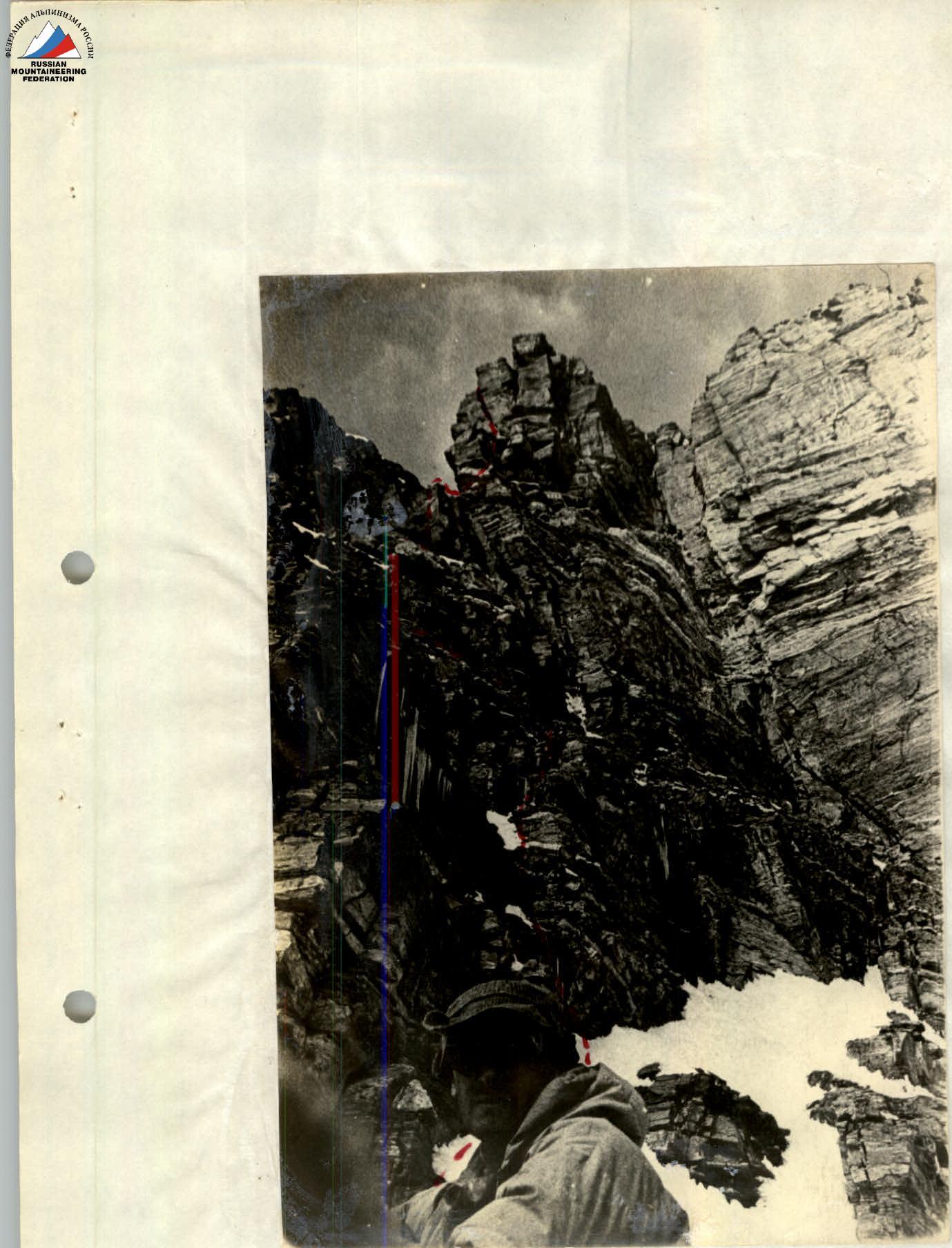
Passage of section R13–R14
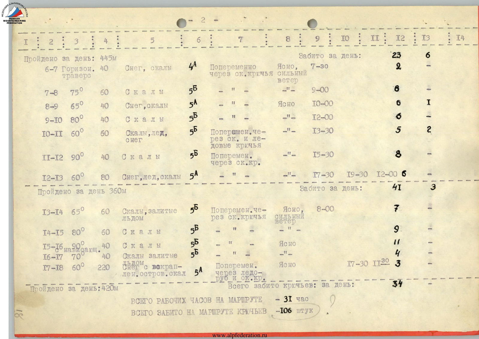
Table
of the main characteristics of the most complex sections of the ascent to peak 6007 m in the ridge of p. Litvy via the southwest wall. The height difference is 1107 m, the average steepness is 75°, the length of the route is 1225 m, the most complex sections — 440 m.
| Date | Section | Steepness | Length | Character of relief | Techn. difficulty | Insurance methods | Weather conditions | Time taken to pass the section | Overnight stay | Working hours | Rock hooks | Ice hooks |
|---|---|---|---|---|---|---|---|---|---|---|---|---|
| — | R0–R1 | 55° | 80 m | Snow-ice | 4B | Alternate through rock and ice hooks | Clear | 7:00 | — | — | 2 | 2 |
| — | R1–R2 | 55–60° | 100 m | Snow with rock inclusions | 3B | Alternate through rock hooks and ice axe | — | 7:30 | — | — | 2 | — |
| — | R2–R3 | 60° | 120 m | —"— | 3B | —"— | — | 9:00 | — | — | 1 | — |
| — | R3–R4 | 55° | 45 m | Snow, rocks filled with atonic ice | 5A | Alternate through rock and ice hooks | — | 10:30 | — | — | 5 | 3 |
| — | R4–R5 | 60° | 40 m | Rocks | 4B | Alternate through rock hooks | — | 12:00 | — | — | 7 | — |
| — | R5–R6 | 65° | 60 m | Rocks, partially filled with ice | 4B | Alternate through rock and ice hooks | — | 14:00 | 16:30 | 2 h 30 min | 6 | 1 |
The platforms for the tent were cut out in the ice. The overnight stay was normal. The height of the overnight stay was 5400 m.
Conclusions on the route
- The route taken by the team is logical, beautiful and absolutely safe.
- The total length of the route is 1225 m (with a height difference of 1107 m), of which 440 m are the most complex sections. 98 rock hooks and 8 ice hooks were hammered on the route.
- Given the technical characteristics of the route, its combined nature and the absolute height of the summit, the team believes that the route is undoubtedly of the highest category of complexity, requiring excellent preparation of each participant individually, mature tactical skill, cohesion and friendship in the team to pass it.
- The team believes that deviating from the route taken along the wall will create additional difficulties.
- The presence of horizontal snow shelves dividing the rock massif of the summit into belts and blocks creates the possibility of arranging 2–3 quite suitable platforms for normal overnight stays on the wall.
- The physical, technical and moral preparation of all team members fully corresponded to the chosen route.
- As a result of the route passage, it became clear that the best number of participants in the group is 6 people.
- The planned tactical plan fully coincided with the actual one. The selected equipment, food and everything necessary ensured the team's success in the ascent.
- The passage of the route was facilitated by a properly chosen regime of nutrition, as well as the excellent weather that prevailed during the passage of the route.
- As a result of the ascent, the participants replenished their technical and tactical arsenal by performing a large amount of labor-intensive and technically complex work at an altitude of about 6000 m.
- The initial report on the ascent was heard by the coaching staff of the Pamir expedition of the DSO "Avangard" and approved as a route of the highest category of complexity — 5B.
Team leader: Simonenko V. K. Senior coach of the team, Honored Master of Sports: Lifshits V. Ya.