
3
Report on the first ascent of Asham peak (5982 m) via the northern counterfort of the Western ridge, category 5B difficulty
Dedicated to the 60th anniversary of the Great October
Moscow, 1977
R5–R14 Section
Map of the area

Brief geographical description of the area and climbing conditions
Asham peak 5982 m is located in the western part of the Shakhdarin ridge, South-West Pamir, between Granatovyy peak 5700 m to the East and Nameless peak 5891 m to the West.
A relatively calm Luknitskogo glacier flows from the cirque formed by Asham 5988 m, Nameless 5891 m, and Luknitskogo peaks.
The glacier's flow merges into Zardiv lake, which is one of the sources of the Sejd river, flowing into the full-flowing Shakhdara near the Sejd settlement.
To the north of Asham peak lies a cirque formed by Granatovyy peak 5700 m, Treugolnik peak, Borovikova peak 5848 m, Uzlovaya 5700 m, and others.
The stream flowing from this cirque's glacier is the second source feeding Zardiv lake. The approach to Asham peak from Sejd settlement, accessible by good roads, follows convenient pack trails.
Under the southern walls of the large cirque formed by 5962 m peak, Granatovyy, Asham, 5891 m, Baykonur, Grechko peak, 5745 m, and Luknitskogo peaks lie Zugmund and Putup glaciers, with their respective rivers flowing into Pyandzh.
In 1904, the area was visited by B.A. Fedchenko on an expedition, who first described it in the "News" of the Imperial Botanical Garden. Seventy years later, reconnaissance climbers led by V.P. Nekrasov, Master of Sports of the USSR, first appeared in the area, and by 1975, its mountaineering exploration began.
In 1975 and 1976, climbers from the Armed Forces of the USSR, as part of the Union Championship, tackled the walls of Luknitskogo peak. In 1975, army climbers under V. Nekrasov's leadership ascended Luknitskogo peak via the NW ridge, rated 5B category. Most other peaks remained untouched until 1977.
The harsh, demanding serious technical and especially tactical preparation, northern side of Asham peak remained unclimbed until 1977.
Three ribs lead to the western ridge of Asham peak from the north, each posing a significant challenge to climbers. All are prone to rockfall, especially in their lower sections. The ribs feature steep and sheer walls with overhanging sections, presenting the most serious obstacles on the route.
Weather conditions in the area are favorable for mountaineering, similar to the rest of South-West Pamir.
Brief description of the ascent object
Asham peak 5982 m is situated in a spur of the western part of the Shakhdarin ridge. It is one of the highest and most majestic peaks in the area. Based on preliminary observations, an ascent from the north was deemed most challenging.
The group, during a training ascent on Shukshin peak, began scouting a route on this beautiful peak.
Three pronounced counterforts lead to the western ridge of Asham peak; after detailed reconnaissance, the group chose the westernmost rib as the safest, which was confirmed during the ascent.
Approaching the other two counterforts is problematic due to numerous rockfalls hitting their lower sections.
The counterfort leading to the ridge is technically the most challenging section of the route. The route is combined: the upper part includes sections with flowstone ice; there are purely ice sections; the summit exit is a snow-ice slope.
The chosen route is of significant sporting interest as a technically challenging climb requiring the group to master all techniques for overcoming complex sections (using ladders, creating artificial holds, navigating overhangs, flowstone ice, and rope-pulling).
This route is the most logical for ascending the peak from the north.
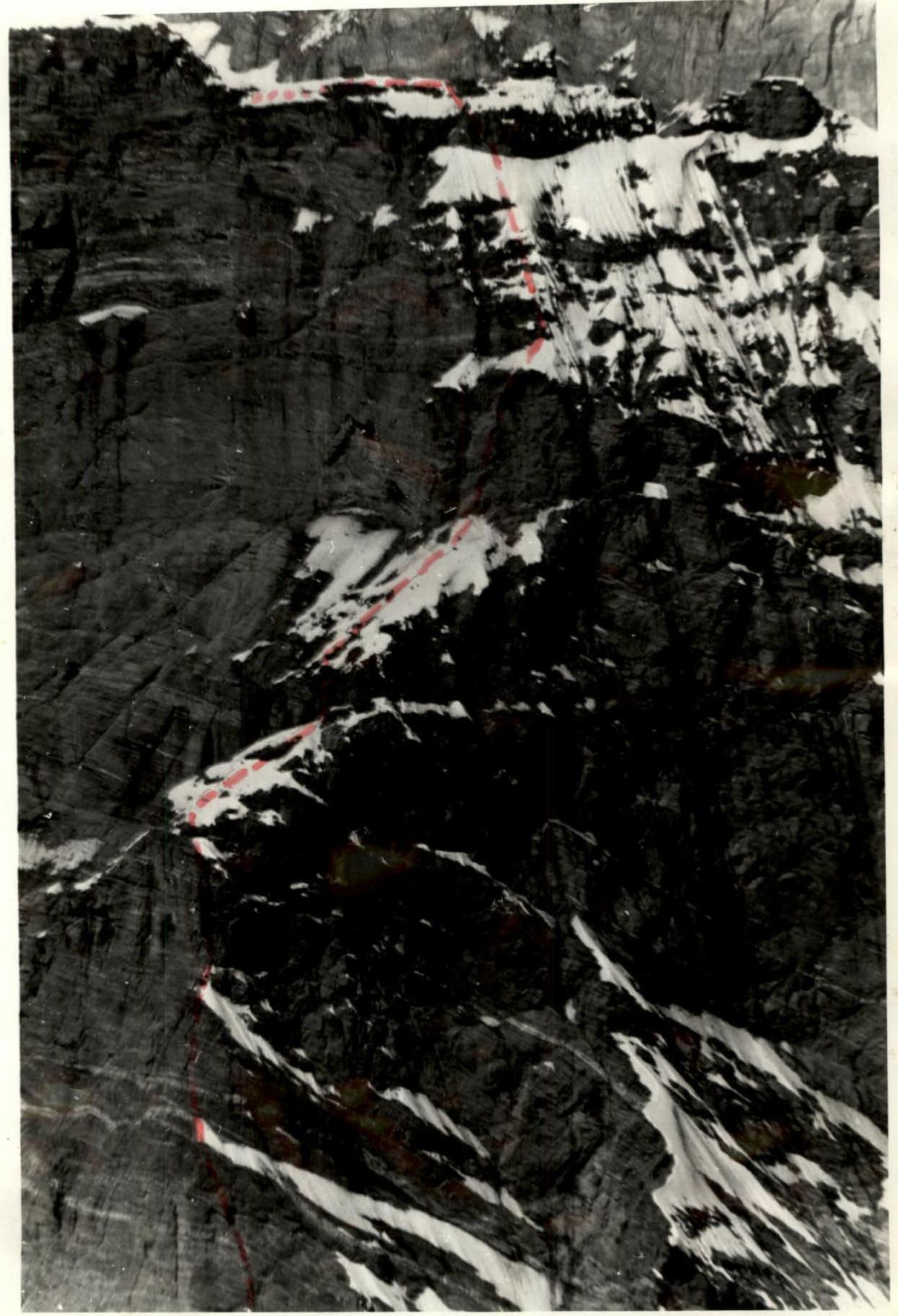
Route description
July 12, 1977. For a more detailed reconnaissance, team leader Sadovnikov V.G. and Ponomarenko Yu.V. set out under the northern walls of Asham peak. Throughout the day, the pair observed the route through binoculars and monitored rockfall activity. This sortie clarified the route and informed the tactical ascent plan.
July 13, 1977. After the pair's return and agreement on the tactical plan, the group headed under the route.
From the base camp, they followed the right side of the river flowing from the Borovikova peak cirque's glacier, approaching the rib of Asham peak. A bivouac was set up near a large stone on the left side of the river.
The same day, the Sadovnikov V.G. and Ponomarenko Yu.V. rope team processed the lower wall.
From the bivouac site, they traversed moraine and grassy slopes to reach the broken rocks, then ascended rocks to the right of the couloir separating the 2nd and 3rd ribs, to the Black couloir, which was being flushed with water. (Beware of rockfall from the couloir!)
R0–R1 Section (75 m, 80°)
To the left of the couloir, they ascended the wall.
The first 40 m featured overhanging sections, navigated using ladders. The rocks were monolithic, with a slab-like structure and few holds or cracks.
Further ascent followed a groove, emerging onto the ridge. Along the ridge to a small ledge, and through an overhanging wall, they reached a snow patch.
The route's beginning was quite challenging, instilling a serious and determined mindset in the group for the ascent.
R1–R2 Section (105 m, 65°)
This was one of the route's most difficult sections. The first climber ascended without a backpack, and the rest were rope-pulled.
From the snow patch, they ascended a narrow chimney, reaching a ledge, then continued up another chimney, which became inclined and overhanging at the top.
The ledge led to a crack, and after the overhang, the chimney narrowed, and the crack was traversed on ladders. This overhanging crack led to the ridge.
R2–R3 Section (135 m, 60°)
Along the ridge to a gray wall, and up it (cautiously! live blocks!), to a small ledge. Then, via rocks, they reached a large black wall.
The wall was traversed with extreme caution (crumbly rocks!) and upward to a red layered wall.
R3–R4 Section (160 m, 55°)
Up the red wall directly to the ridge and along it to a black wall, which was traversed using ladders. After the wall, they moved alternately along the ridge to the "Trapezia" pinnacle.
Up the wall of the pinnacle and then a challenging traverse right to a niche.
R4–R5 Section (40 m, 70°)
From the niche, up the wall through an overhanging section and then right - a traverse and up the wall with a crack through a small overhang - to a platform at the "Trapezia" pinnacle. On the platform, they built a cairn.
After a short rest, one rope team processed the wall, which looked very imposing.
R5–R6 Section (170 m, 60°)
From the platform, a straightforward ridge led to the wall. The center of the wall was cut by a huge chimney, and to the left of it, a crack was chosen for further ascent.
The crack led to a small ledge protected from rocks by a rock overhang. From the ledge, a psychological traverse left onto a slab.
Ascent up the smooth, steep slab was complicated by a small ledge, which was traversed with a ladder. Further ascent led to a wall with an overhanging crack.
The exit from the crack was complicated by crumbling rocks, requiring extreme caution. Approach to the gray striped wall was via live blocks! End of processing.
July 15, 1977. From this rock pile, they traversed a small wall right to a large wall and along it - a traverse right to a ledge behind a huge rock fragment located to the right of the chimney.
R6–R7 Section (130 m, 65°)
From this ledge, directly up the wall - climbing was difficult and hazardous. Further right and up - to an internal angle, and along it - to a ledge under the second wall ascent.
Along the internal angle cutting through the entire wall - to a small narrow ledge. From the ledge, directly up - a black sheer face with a ledge and overhangs; climbing was extremely challenging. The wall led to a small snow patch.
R7–R8 Section (120 m, 70°)
From the snow patch, a small ridge led to the 3rd wall ascent. Up the wall, directly through overhanging sections - to a rock niche (half-cave). Water dripped from the ceiling.
From the niche, an exit through a ledge - to a marble belt. The marble belt was traversed with challenging climbing: first up the wall, then along an internal angle - to a small ledge.
R8–R9 Section (190 m, 35°)
From the ledge, left and up to a huge stone and through it - to the ridge. Along the ridge and scree-covered, snow-dusted rocks with ice - to a wall with a chimney.
R9–R10 Section (40 m, 75°)
Up the wall, left and into the chimney, and up it. At the top, an exit to the ridge to the right of a "plug."
R10–R11 Section (120 m, 40°)
Along the ridge up to a small wall. It was bypassed on the left, and via rocks of medium difficulty, and scree-covered ledges - they approached under the wall ascent.
Under a small overhang of the wall, they carved out a platform in the ice and on the slope.
R11–R12 Section (100 m, 80°)
The same day, they processed a small section. From the overnight stop, right - bypassing a ledge, and up-left along a slab - to an internal angle.
Due to the late hour and fatigue, further processing was postponed. The participants' presence above the ledge also posed a risk to those below setting up the bivouac.
July 16, 1977. Ascent up the internal angle and further along a crack. The crack led to a small ledge under the wall ascent. The ledge could only accommodate two.
Directly up under the first ledge (traversed with a ladder). After the ledge, a slab led to the second ledge (also traversed with a ladder). To the right of the ledge stood a slab (caution!). Through the ledge - to a small sloping ledge, accommodating two with great difficulty.
Above the ledge - a new ledge. Exit through it, even with a ladder, was very challenging. Immediately behind the ledge - a smooth slab with almost no holds.
To the left lay a couloir, but passage through it was hazardous due to periodic rockfall. The third ledge was traversed right along the slab to a granite wall. Further under the wall, left and up - to the couloir, and along its right side (rocks fell from the left) - to a gray wall. The wall was traversed on the left.
R12–R13 Section (180 m, 45°)
After the wall, a ridge began, along which they ascended left and up to a red wall. This wall was bypassed on the left and further - up to a small snow patch under a new wall.
The wall again led to the ridge. The ridge presented no difficulties, but a new obstacle appeared - a large slab-like wall.
R13–R14 Section (60 m, 65°)
The wall was traversed at a point of lowering, resembling an internal angle. Climbing in the angle was challenging due to flaking rocks.
After the internal angle - a small ledge. From the ledge, directly up the rocks (very crumbly! extreme caution required!).
The exit to the western ridge presented no significant technical difficulties. Directly on the ridge, near the exit point, lay a suitable platform for an overnight stay.
July 17, 1977. R14–R15 Section (460 m, 10°). From the overnight site, directly along the ridge under the "Submarine" pinnacle wall and further - an easy traverse along a terrace to the right. In places, the terrace was covered with flowstone and glacier ice, complicating progress. In such areas, protection was set up using pitons.
R15–R16 Section (140 m, 35°)
The terrace led to a couloir. Ascent up it was not particularly difficult but hazardous (rocks fell!). They traversed left onto a wall and up it to the start of an internal angle.
The internal angle led left and up under a new wall with an overhang. Ladders were used again. The wall was monolithic, with few cracks or holds - making progress very difficult.
The first climber ascended without a backpack; the others were pulled up on Jumars, which was very tiring, and the altitude was starting to take its toll.
After the wall, they entered a rock niche for a short rest.
The route was visible to the ridge, which was reassuring. "Submarine" was passed! Observations from below did not reveal an alternative route around this pinnacle.
R16–R17 Section (120 m, 40°)
From the niche, along an osypnaya ridge right and up - to a light-colored, crumbly wall. A short ascent up it, and the wall was bypassed on the right.
R17–R18 Section (500 m, 20°)
Further along a small ridge (with snow in places) and a black wall, to the left of a couloir, and up it - to a ledge. Along the ledge and rocks of medium difficulty, left and up - to the ridge.
Along the ridge, keeping to the right side, they bypassed three pinnacles on the right and reached the ridge.
Progress along the ridge was challenging: the rocks were very crumbly, the ridge was sharp, and on both sides, it dropped away with walls.
The ridge led to a saddle before the pre-summit rock ascent. Here, they stopped for a bivouac. The second half of the day was unfavorable - snow was falling. They quickly set up a tent, with strong winds making it hard to rest. Snow periodically had to be shaken off the tent's slopes. It was very cold, with the wind threatening to rip the tent, and they had to hold it down.
July 18, 1977. R18–R19 Section (240 m, 40°)
From the saddle, directly up the ascent. The pessima had greatly complicated the route. All rocks were covered in snow, and they had to clear it by hand. Movement was predominantly to the right of the ridge. At the end of this section, they reached a suitable platform for a good overnight stay.
R19–R20 Section (160 m, 55°)
From the platform, up and right - bypassing a rock wall. The wall was bypassed on the right via ice and then to a small sloping ledge protected by a red wall. This wall was also bypassed on the right via ice, emerging under a large black wall. There, an excellent large ledge was found.
Along the ledge, they moved right to a small red wall, and up it - to a small icy ledge. From the ledge - ascent up a crack to the right. All cracks and the crack were filled with ice - setting up protection was challenging. Up the crack - a difficult ascent on ladders to a small ledge. This was a very unpleasant section.
R20–R21 Section (80 m, 40°)
From the ledge, up to the ridge - via несложным скалам, и далее по скальному гребню выходим к снежно-ледовому склону.
R21–R22 Section (800 m, 25°)
Then along the ice slope, covered with a thin layer of snow, left and up. After the slope's inflection, the steepness decreased, and the slope's condition improved, but the altitude was taking its toll, and every step toward the summit was challenging. The summit was snowy, and to the right on the rocks, they built a cairn, after which they began descending along the ridge toward Uzlovaya peak 5891 m.
Just below the summit, they stopped for a bivouac. Along the ridge down to the lowering and then - ascent along the ridge toward Uzlovaya peak. Ascent to the couloir leading to the snow fields, which lead to Uzlovoy glacier.
Along the glacier - descent to the moraine, and further - to Zardiv lake.
Evaluation of participants' actions during the ascent
All group members demonstrated excellent physical, tactical, and technical preparation during the ascent. The route was completed at a good pace with proper organization of protection.
Team coach - (Kazunenko V.) Master of Sports of the USSR
Team captain - (Sadovnikov V.)
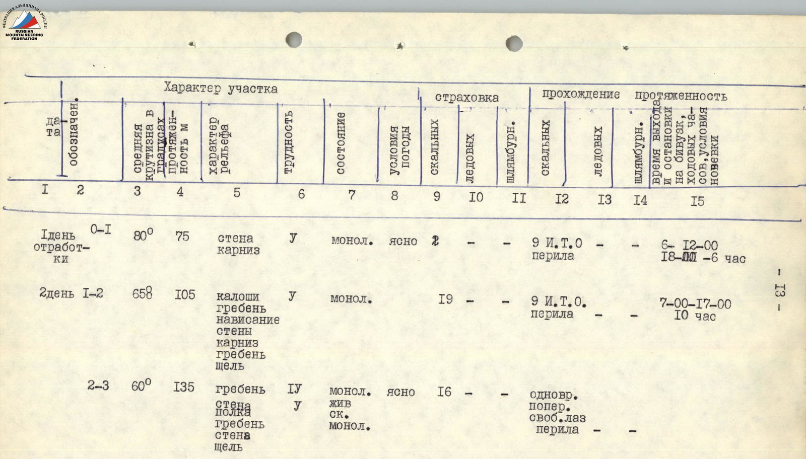
| Date | Designation | Average steepness in degrees | Length, m | Relief character | Difficulty | Condition | Weather conditions | Pitons: rock | Pitons: ice | Pitons: bolt | Passage: rock | Passage: ice | Passage: bolt | Length and stops on bivouac, corresponding overnight stay conditions |
|---|---|---|---|---|---|---|---|---|---|---|---|---|---|---|
| 1st day processing | R0–R1 | 80° | 75 | wall, ledge | 2 | monolithic | clear | 2 | – | – | 9 ИТО, перила | – | – | 6:00–12:00, 18:00 – 6 ч |
| 2nd day | R1–R2 | 65° | 105 | chimney, ridge, overhang, walls, ledge, ridge, crack | 2 | monolithic | 19 | – | – | 9 ИТО, перила | – | – | 7:00–17:00, 10 ч | |
| R2–R3 | 60° | 135 | ridge, ledge, wall, ridge, wall, crack | 4 | monolithic, live rocks, monolithic | clear | 16 | – | – | simultaneous, alternating, free climbing, перила | – | – | ||
| R3–R4 | 55° | 160 | slab, crack, wall, ridge, wall, niche, ledge | 4 | monolithic | clear | 19 | – | – | alternating, free climbing, ИТО, перила | – | – | ||
| R4–R5 | 70° | 40 | wall, overhang, ledge | 2 | monolithic | clear | 5 | – | – | 1 ИТО, перила 15 | – | – | ||
| 3rd day | R5–R6 | 60° | 170 | ridge, crack, slab, ledge, crack, overhang, wall, crack | 2 | monolithic, live complex | clear | 19 | – | – | alternating, 2 ИТО, free climbing, перила | 1 | – | 7:00–9:00, 12 ч |
| R6–R7 | 65° | 130 | wall, internal angle, ridge, wall, internal angle, wall, overhang | 2 | monolithic | clear | 14 | – | – | alternating, 1 ИТО, free climbing, перила | – | – | ||
| R7–R8 | 70° | 120 | ridge, snow, wall, overhang, ledge, overhang, ledge, internal angle | 2 | snow-covered, monolithic | clear | 14 | – | – | alternating, 3 ИТО, free climbing, перила | – | – | ||
| R8–R9 | 30° | 190 | ridge, snow slopes | 3/4 | monolithic, snow-covered, live rocks | clear | 5 | – | – | simultaneous, alternating | – | – | ||
| R9–R10 | 75° | 40 | stones, ledge, wall | 2 | monolithic | clear | 54 | – | – | alternating | – | – | ||
| R10–R11 | 40° | 120 | slope, live rocks, ledge | 2 | live rocks, snow, ice | clear | 1 | – | – | simultaneous | – | – | ||
| 4th day | R11–R12 | 80° | 100 | slab, internal angle, crack, ledge, ledge, slab, ledge, ledge, slab, wall, chimney | 6 | monolithic | clear | 15 | – | – | alternating, 3 ИТО, free climbing, перила | – | – | 8:00–17:00, 9 ч |
| R12–R13 | 45° | 180 | ridge, wall, rocks | 3/4 | snow-covered | clear | 8 | – | – | simultaneous, alternating | – | – | ||
| R13–R14 | 65° | 60 | wall, slab, internal angle, ledge, chimney, wall | 2 | monolithic, VA, live rocks | clear | 9 | – | – | sub-alternating | – | – | ||
| 5th day | R14–R15 | 10° | 460 | ridge, large ledges | 2 | live, snow-covered | cloudy, snow, wind | 5 | – | – | 3 simultaneous, alternating | – | – | 8:00–18:00, 10 ч |
| R15–R16 | 65° | 140 | couloir, wall, internal angle, couloir, wall, ledge, slab, overhang, niche | 2 | monolithic, live rocks | cloudy, snow, wind | 18 | – | – | alternating, перила | – | – | ||
| R16–R17 | 40° | 120 | ledge, slope, wall, couloir | 3/4 | live rocks, snow-covered, ice | snow, wind, cloudy | 3 | – | – | alternating | – | – | ||
| R17–R18 | 20° | 500 | ridge, wall, ledge, ridge, ledge, scree, slab, ridge | 3/4 | ridge, live rocks, snow-covered | "-" | 5 | – | – | simultaneous, along the ridge | – | – | ||
| 6th day | R18–R19 | 40° | 240 | ridge, wall, snow-covered, crumbly rocks | 3/4 | snow-covered, rocks, icy, rocks | 5 | – | – | alternating, перила | – | – | 9:00–18:00, 9 ч | |
| R19–R20 | 55° | 160 | icy rocks, ice slope, ledge, icy rocks, crack, ice | 2 | ice, icy, rocks | 10 | 5 | – | перила, 1 ИТО | перила, 1 ИТО | – | |||
| R20–R21 | 40° | 80 | wall, scree | 3 | snow-covered, icy, rocks | 4 | – | – | alternating | – | – | |||
| R21–R22 | 25° | 800 | ice, firn slope | 3 | ice, log | 19 | 12 | – | simultaneous, alternating, 1 | – | descent 8–21 |