ASCENT DOCUMENT
-
Ascent category — technical.
-
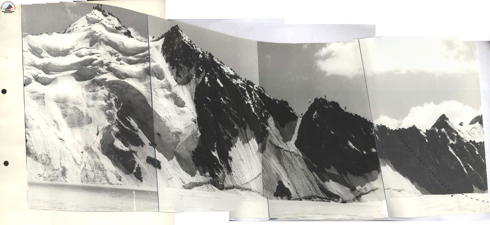
Ascent area — D.Z. Pvivr, Ruban Range.
-
Ascent route — First ascent of Pik Kosmonavtov–5420 m, via the north ridge.
-
Ascent characteristics:
height difference — 800 m (1,000 m from the bivouac); average steepness — 45–50°; length of difficult sections — 120 m.
- Pitons hammered in:
rock — 33; ice —; protection —.
-
Total climbing hours — 17.
-
Number of nights — 1.
-
Ascent made by a group of climbers from the Sports Committee Expedition of the Tajik SSR.
-
Surname, first name, patronymic of the leader, participants, and their qualification:
Solovyov Mikhail Alexandrovich — 2nd sports category, leader; Bolnitsev Vyacheslav Timofeevich — 2nd sports category, participant; Kozlov Pavel Vladimirovich — 2nd sports category, participant; Kapitanova Tatyana Vasilovna — 2nd sports category, participant; Suzdalev Sergey Semenovich — 2nd sports category, participant.
-
Team coach: Sogrin Sergey Nikolayevich, Master of Sports of the USSR.
-
Ascent made on July 29–30, 1975.
DESCRIPTION OF THE ASCENT ROUTE
From the expedition base camp, follow the trail through the Uleriy summer camp to the right moraine of the Raumid Glacier for a 4-hour approach to the overnight stop.
- From the overnight stop on the right bank moraine of the Raumid Glacier, exit onto the glacier and approach the saddle in the north ridge of the peak (1 hour). The saddle is located between a large gray gendarme (right) and a reddish rock (left).
The ascent to the saddle is via moderately difficult rocks with a steepness of 45–50°. Protection via protrusions. The section is 100 m long.
-
Along the ridge for 100 m, bypassing gendarmes on the right as you go, via easy to moderately difficult rocks. Then, exit onto a sharp ridge. Movement is simultaneous.
-
Along the ridge for 100 m via moderately difficult rocks. Movement is simultaneous and alternating. Then, bypass the first large gendarme on the right and exit onto the ridge via a broken wall — 40 m. Some sections have ice buildup. Steepness is 60–70°. Protection is via pitons. The total length of this section is 140 m. 5 pitons were hammered in.
-
From the ridge, descend to the right via a couloir. Then, follow ledges along the ridge and descend via the next couloir onto a snow-ice saddle — 120 m. Movement is simultaneous and alternating. Protection via protrusions.
-
From the saddle, ascend a wall — 40 m of difficult climbing. Protection is via pitons. Steepness is 70°. Then, follow a snow slope with a steepness of 60° for 60 m. Movement is alternating. Protection via ice axe. After the snow slope, follow a rocky overhanging ridge resembling a snow cornice — 40 m. Then, descend via a rope into a depression — 10 m. The total length of this section is 170 m. 7 pitons were hammered in.
-
From the depression, ascend a steep ridge ending in a gendarme — a "finger." The ridge alternates between rocky walls with a steepness of 60–70° and snow ascents with a steepness of 45–50°. Movement is alternating. Protection is via pitons and, on snow, via ice axe. The length of this section is 200 m. From the "finger," descend via a rope — 20 m. 12 rock pitons were hammered in.
-
Ascend to the "mandari," leading to the pre-summit snow ascent. The "mandari" is a steep snow slope-ascent with ice and frozen rock outcrops (150 m). After the snow slope, a rocky ridge begins, which is bypassed first on the right via ledges and then exited onto it a bit further from the "mandari" peak (40 m). Then, follow the ridge with a straightforward descent onto a snow saddle (60 m). The total length of this section is 250 m. Protection via ice axe and, at rock outcrops, via pitons. 7 rock pitons were hammered in.
-
From the saddle, ascend a snow slope to exit onto the east ridge of the peak. Do not deviate from the ridge as it is prone to cornices. Bypassing cornices on the right as you go, ascend to the rocks forming the summit. Protection is initially simultaneous, then becomes alternating via ice axe as steepness increases and after encountering cornices. The length of this section is 300 m.
-
Follow moderately difficult rocks to reach the summit. Protection via protrusions and pitons. 2 rock pitons were hammered in. The length of this section is 60 m.
The descent from the summit is southward via a couloir for 40 m. Then, move left under overhanging cornices of the east ridge for about 60 m and exit onto the ridge itself. The ridge is wide and snowy. Some sections have cornices, which are bypassed on the right as you go. Descend to the lowest point on the ridge and then follow a snow slope of moderate steepness — descend left onto
 Pik Kosmonavtov (descent from the Payakhnu Glacier) Raumid Glacier. The descent from the summit follows route 2A category of difficulty, then returns to the moraine via the glacier.
The group named the peak Pik Kosmonavtov. However, the route's overall difficulty is category 4B.
MAIN CHARACTERISTICS OF THE ROUTE
-
1. Section R1 (July 29–30, 1975):
- Angle: 45–50°.
- Length: 100 m.
- Description: Broken rocks.
- Section difficulty category: 2A.
- Movement type: Free climbing, simultaneous movement.
- Weather: Snowfall.
- Notes: 7:00 AM, departure from overnight stop.
-
2. Section R2:
- Angle: 30°.
- Length: 100 m.
- Description: Ridge.
- Section difficulty category: 2A.
- Movement type: Simultaneous movement.
- Weather: Snowfall.
-
3. Section R3:
- Angle: 30°; 60–70°.
- Length: 100 m; 40 m.
- Description: Ridge; gendarme.
- Section difficulty category: 4A.
- Movement type: Free climbing.
- Protection: Pitons.
- Weather: Snowfall.
- Notes: 5 pitons hammered in.
-
4. Section R4:
- Angle: 45–50°.
- Length: 120 m.
- Description: Couloirs and ledges.
- Section difficulty category: 2.
- Movement type: Simultaneous movement.
- Weather: No precipitation.
-
5. Section R5:
- Angle: 70°; 60°; 20°.
- Length: 40 m; 80 m; 40 m.
- Description: Wall; snow slope; ridge.
- Section difficulty category: 4A.
- Movement type: Simultaneous movement.
- Protection: Pitons, via ice axe.
- Weather: No precipitation.
- Notes: 7 pitons hammered in.
-
6. Section R6:
- Angle: 45–70°.
- Length: 200 m.
- Description: Rocks and snow slopes.
- Section difficulty category: 4A.
- Protection: Pitons and via ice axe.
- Weather: No precipitation.
- Notes: 12 pitons hammered in.
-
7. Section R7:
- Angle: 50°; 30°; 20°.
- Length: 150 m; 40 m; 60 m.
- Description: Snow and frozen rocks; ledges and small walls; ridge.
- Section difficulty category: 4A.
- Movement type: Simultaneous movement.
- Protection: Pitons and via ice axe; piton protection.
- Weather: No precipitation.
- Notes: 7 pitons hammered in.
-
8. Section R8:
- Angle: 50°.
- Length: 300 m.
- Description: Snow ascent and snow ridge.
- Section difficulty category: 4A.
- Protection: Via ice axe.
- Weather: No precipitation.
- Notes: 10:00 PM, stop for overnight in a tent.
-
9. Section R9:
- Angle: 50°.
- Length: 60 m.
- Description: Gendarmes.
- Section difficulty category: 3.
- Protection: Pitons.
- Weather: No precipitation.
- Notes: 2 pitons hammered in.
Group leader — Solovyov M.A., 2nd sports category. Coach — Sogrin S.N., Master of Sports of the USSR.