
Report
on the ascent of Pik Suloeva via the SW wall, right buttress, category 5B, second ascent, Central Pamir, Fortambek Glacier; accomplished by a group of climbers from the CS F and S expedition from August 10 to 12, 1980, consisting of:
- Petrov A.E. — leader, 1st sports category, instructor
- Maltsev I.V. — participant, 1st sports category, doctor
- Troyanov V.M. — participant, 1st sports category
- Filonov Yu.V. — participant, 1st sports category
MOSCOW 1980
Since the first ascenders do not submit their route for classification, by agreement with V. M. Bozhukov, this route can be considered a first ascent.
November 20, 1980 A.E. Petrov
Pik Suloeva
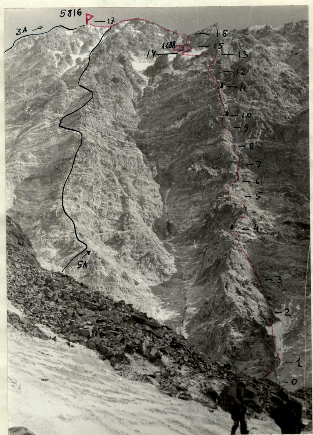
August 11. SW wall from the glacier under the route. The route along the right buttress is marked in red.
With the aim of alpine exploration in the Fortambek Glacier area in the Central Pamir, fulfilling sports category norms, and participating in the 1980 CS F and S alpinism championship, a group of climbers from the CS F and S expedition consisting of:
- Petrov Andrey Evgenievich — leader, 1st sports category, instructor, team 86
- Maltsev Igor Viktorovich — participant, 1st sports category, doctor, team 86
- Troyanov Vladimir Mikhailovich — participant, 1st sports category
- Filonov Yuri Vladimirovich — participant, 1st sports category, team 36
completed an ascent of Pik Suloeva via the SW wall (right buttress) from August 10 to 12, making the second ascent of the route climbed on July 8, 1980, by a duo from the International Alpine Camp "Pamir-80" comprising O. Kosmachev and V. M. Bozhukov — category 5B approximately.
Pik Suloeva (5816) is located in the Central Pamir in the upper reaches of the Fortambek Glacier. It closes the cirque of the Suloeva Glacier with its SW rock wall. This glacier flows into the Tanymas Glacier (upper reaches of Fortambek), dropping steeply to it with an ice wall. Above, the Suloeva Glacier is broken by three beautiful, almost sheer hundred-meter icefalls.
Pik Suloeva is situated in a lateral spur of the Peter the First ridge, branching off to the west from Pik Moskva. In this ridge, separated by saddles, stand Moskva, Pik 30-letiya Sovetskogo gosudarstva, and the three-headed Pik Oshanina — three powerful six-thousanders. Then the ridge descends to the Shini-Bini pass (5100) and rises to Pik N. Krupskaya 6008. From Krupskaya, a long ridge extends to the NE, featuring the beautiful Pik E. Shataeva, 5750, with a twin-peaked white rock tower, before descending to a 5300 pass and rising to Pik Suloeva 5816 — a snowy, gently sloping ridge, ascending which is classified as 3A.
To the SE from Pik Suloeva, the ridge descends to Pik U. Umarova 5200 and further to the Suloeva meadow, located on the left bank of the Fortambek Glacier — a site for many Pamir expedition base camps at 4000. On the opposite right bank of the Fortambek Glacier rise the picturesque and formidable two-kilometer walls of the Big Pamir Plateau 6000 and above them — the highest point of the Soviet Union — Pik Kommunizma 7495.
Pik Suloeva stands out among other peaks in this area with its technically challenging SW rock wall.
- The height difference from the glacier to the summit is 1200 m, and the relatively low absolute height of the peak allows for complex ascents by pairs.
- Nevertheless, until this summer, only one route had been laid on the wall — via the SW wall, left buttress.
- As of this season, its category was downgraded from 5B to 5A.
- The simplest descent route from the summit is along the SW ridge, category 3A.
This season, our expedition's climbers made a first ascent of the SE ridge: a traverse of Umarova–Suloeva, approximately category 4B–5A.
Then, in preparation for the first ascent of the SW wall by a group of climbers not participating in the USSR Championship in the high-altitude category, the duo A. Petrov — Yu. Filonov reconnoitered the descent route by ascending the SW ridge (category 3A) and then traversing the parallel route along the left buttress (category 5A). The ascent from the foot to the summit along the wall took 7 hours. The participants assessed it as corresponding to category 5A. The most challenging part of this route is about 200 m. Otherwise, the route proceeds along ridges and ledges.
All this allowed us to familiarize ourselves closely with the upcoming ascent route and devise a tactical plan. It became clear that the route is very logical and much more challenging than the one along the left buttress.
Preparing for the ascent, we learned that the route had already been climbed in early July by a duo from the International Alpine Camp "Pamir-80" comprising O.S. Kosmachev — V.M. Bozhukov. This fact did not deter us. Rather, it sparked a desire to be the second group to climb the route ascended by climbers whose names in Soviet alpinism require no introduction or commentary.
Approach to the route. From the Suloeva meadow, we followed a trail along the Fortambek Glacier to the entrance of the Suloeva Glacier gorge. On the crest of a lateral moraine, a cairn was built, indicating the descent to the glacier. From here, we ascended along the ridge, then traversed the talus slope under the rock slope of the Umarova peak's ridge, reaching the Suloeva Glacier above the ice wall. Along the moraine, then the glacier, staying close to the glacial stream, which was sometimes blocked by boulders, we reached the first icefall. This and the next icefall were passed on the left, traversing moraines, ice, and snowy slopes. Above the icefalls, we followed the even glacier to approach the wall (beware of rocks falling from the wall onto the glacier!! — early passage). A convenient campsite is at the entrance to the gorge on the moraine. One can also camp under the wall on the glacier, but it's safer to stay further from the wall.
We left the camp on August 10 at 18:00. By 19:30, we reached the entrance to the gorge and camped on the moraine to unload the next day, intending to reach the summit by climbing due to concerns about "easy life." According to our information, the previous group ascended without camping, but they were a duo, traveling lightly, and significantly more experienced. So, we didn't count on an "easy life," packing supplies and gear for a 2–3 day ascent. The weather had been unstable in recent days; we ascended the left buttress route amidst hourly snow showers and strong winds.
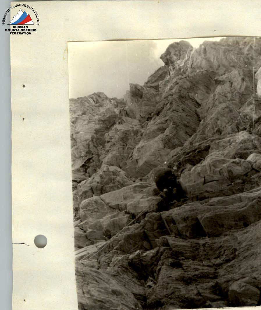
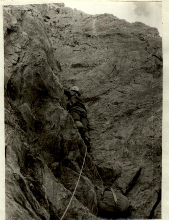
Route description. On the glacier under the route, we tied in: Petrov — Maltsev, Filonov — Troyanov. R0–R1. We took turns crossing a very "lively" steep talus under the wall that drops off the right buttress of the SW wall of Pik Suloeva — to avoid being hit by rocks periodically falling down the wide right couloir. Under the cliffs, we moved right into the couloir. 100 m, 35°. R1–R2. Along ice covered with rocks, we made our way along the cliffs, away from the middle part of the couloir. Alternate belay. 60 m, 40°. R2–R3. Along a snowy slope, then destroyed rocks, talus rocks, with unreliable footholds. We moved right below the ridge of the buttress. Petrov led the rope, setting up a belay. (It's worth recommending to future groups to exit to the ridge left here, a bit earlier than we did — this would be safer from potential rocks above.) Immediately after, Filonov emerged under overhanging rocks. Further, the teams strictly alternated, and this tactic allowed us to move quickly and reliably. 80 m, 45°, 4 pitons. R3–R4. Left under the wall, a difficult traverse under the cliffs, then along an internal corner, two ropes were passed in turn by Filonov and Petrov. We exited onto the ridge, which abuts the wall of the buttress above — the most challenging part of the route. Climbing was difficult — although the terrain was fairly broken, the rocks crumbled in unexpected ways. 80 m, 65°, 4 pitons, 1 nut. R4–R5. Along the ridge, we moved simultaneously with alternate belay to the wall. The ridge was quite steep. On the saddle where we exited onto the ridge, a belay is possible. 10 m above, we built a control cairn. Under the wall's start, a semi-reclining belay can also be organized. 100 m, 45°. R5–R6. Filonov. Along rocks above average difficulty and challenging, then into a couloir. The overhang was climbed head-on. Very difficult climbing; a piton with a carabiner was used as an artificial support point (ASP), followed by difficult climbing leading to a narrow long ledge under overhanging rocks. Here, we unexpectedly found a juice can with a note from the first ascenders: O.S. Kosmachev and V.M. Bozhukov, dated July 8, 1980. We confirmed that the information about the first ascent was correct and that we were on the right path to the summit. Accepting best wishes and two chocolate candies from the first ascenders with gratitude, and leaving our own note, we continued. 50 m, 75°, 5 pitons, 1 nut. R6–R7. Petrov. 5 m along the ledge to the right into a vertical couloir, then 25 m of difficult climbing under an overhang. Under the overhang, a traverse to the right; holds were unreliable; thus, after driving a long piton into a wide crack, it was convenient to make a 5 m pendulum down-right onto a rock rib and then 10 m onto a small ledge. 40 m, 75°, 5 pitons, 2 nuts.
On section R8–R9. Exit via a fixed rope onto a ledge under overhanging rocks.
The key place on the route — an internal corner. Section R9–R10. Altitude 5500 m. At the bottom — ladders, and at the top — beautiful white marble slabs await. R7–R8. Filonov. 15 m left onto the edge of the buttress. Then along a chimney 20 m down a stream (apparently, from the mouth of a large characteristic rock "funnel"). This funnel is clearly visible from below and serves as an orientation point. Our route follows its left wall. Interestingly, where did the first ascenders go? Above the stream, 15 m of difficult climbing onto a wide talus ledge. To somewhat straighten the rope, we set up a belay. 50 m, 65°, 2 pitons, 1 nut. R8–R9. Petrov. Along the ledge, then vertically up the rocks, overcoming a cornice of destroyed rocks (beware of rocks!), with difficult climbing — exit onto a 40 m ledge under overhanging rocks at the mouth of the funnel. The ledges were covered in debris. Then Filonov traversed left along the ledge, then left-up, bypassing overhanging rocks with difficult climbing, re-emerging onto the edge of the buttress (left wall of the funnel), onto a ledge. 80 m, 70°, 7 pitons, 2 nuts.
The weather deteriorated. A strong wind blew, and clouds covered the sky.
R9–R10. Petrov. Above us hung a belt of overhanging rocks. Directly above the ledge, it was cut by a vertical, blunt internal corner. The walls were smooth. The rocks crumbled, making the rare holds unreliable; there were no cracks for pitons. At the bottom, the rocks somewhat overhung. Clearing rocks of dust debris, we managed to find cracks to hammer in pitons and, using ladders, advance upward. In the upper part, the chimney was climbed with free, difficult climbing, exiting right onto a ledge — several stable blocks of beautiful white marble. The first ascender wore galoshes and climbed without a backpack. The rest ascended via a fixed rope on jumar clamps. 8 pitons, 2 nuts. 40 m, 90°. R10–R11. Troyanov. Climbed up, then left, bypassing steep rocks with very difficult climbing, emerging onto a 40 m high small ledge.
From here, Petrov climbed 40 m straight up: first along a wall, then left of a vertical rib along an internal corner, finally right again onto the rib. Then Filonov ascended another 25 m along difficult rocks — onto a talus ledge where the first ascenders had built a control cairn. There were too many notes; we built our second cairn above the vertical chimney. 100 m, 75°, 9 pitons, 3 nuts. R11–R12. Along a horizontal ledge to the right under the rocks 20 m into a couloir above the funnel, then left-up along talus rocks in the couloir — onto a rusty, destroyed ridge. We moved cautiously — many loose rocks, with alternate protection. 60 m, 45°, 1 nut. R12–R13. Along the ridge up 100 m towards a rock tower blocking the upper part of the funnel. The rocks were destroyed; climbing was unreliable, with protection alternating between protrusions and bends; beware of rocks! 100 m, 45°. R13–R14. Traversing left-up (towards the summit) along rock outcrops, two snowy couloirs, and bypassing the rock tower on the left, we reached a convenient talus area under the snowy slope of the SE ridge. This area is on a ridge-crest-balcony above the wall; steep snowy couloirs drop down on both sides.
The time was 20:00. We laid out a flat stone area, set up a tent, had dinner, and went to sleep. 80 m, 40°. Strong wind, light snow, but soon everything subsided.
August 12, 1980. The night was quite cold; the tent was frosty. We woke up, gathered, and had breakfast, drying the tent with a primus stove. At 9:30, we headed up towards the SE ridge.
R14–R15. Petrov. Exit under the ridge's rocks along a snowy-talus slope and very unreliable, destroyed rocks. Fixed rope. 100 m, 50°, 2 nuts. The wind blew, and it snowed.
R15–R16. Along a couloir through very destroyed, snowy rocks; in the upper part — along an internal corner with fixed ropes. We exited onto the ridge. Very cold, wind, snow. 150 m, 50°.
R16–R17. Along the ridge simultaneously, with some alternate protection for protrusions along snow and simple rocks. At 12:00, we reached Pik Suloeva 5816. 200 m, 40°.
We descended along the snowy SW ridge, category 3A, setting up a sport descent 30 m on a rocky outcrop, then to the saddle between Pik Shataeva and Pik Suloeva. From the saddle, along talus and then snow — to the glacier. Along the open glacier in teams, we descended to the foot of the SW wall of Pik Suloeva. On the final ice section descending to the start of the route, we organized a sport descent with the rope anchored to an ice screw. Further descent was along glaciers and moraines — via the ascent route.
At 17:20, the group arrived at the base camp on the Suloeva meadow.
Conclusions and Recommendations
- The route is very logical, filled with challenging climbing, objectively safe, combined, corresponding to category 5B.
- A good set of pitons and ladders is required. Rock formations are fragile and fragmented, so channel pitons and various nuts work well.
- The optimal group size is 4 people.
- A night's camp on the route should be planned. Campsites are possible either below the wall or above. On the steep section, sitting campsites on ledges are possible.
- Optimal footwear — Vibram. It's better for the first ascender to climb the chimney without a backpack and in galoshes.
- Descent along the SW ridge, category 3A — is the simplest. For descending on ice to the start of the route, crampons are needed.
- It's better to start the route at dawn — less chance of rockfall. Moving in the dark on the glacier is difficult: apart from other things, it's easy to lose orientation. Therefore, it's better to camp under the route rather than at the entrance to the gorge.
Protocol of August 14, 1980
debriefing of the ascent of Pik Suloeva via the SW wall — right buttress, second ascent, by a group consisting of: A.E. Petrov — leader, I.V. Maltsev, V.M. Troyanov, and Yu.V. Filonov, completed from August 10 to 12, 1980.
Attendees: G.M. Pshakin, G.S. Yakovlev, V.V. Kuznetsov, V.V. Dubrovskikh, A.E. Petrov, I.V. Maltsev, V.M. Troyanov, Yu.V. Filonov.
Pshakin: Please tell us about the ascent, Troyanov.
Troyanov: We left the base camp on August 10, 1980, at 18:00. By 19:30, we reached the campsite on the moraine at the turn into the gorge. It's advisable to leave earlier and camp higher, under the route.
On August 11, we rose at 6:00, departed at 8:00, and started the route at 10:00. The first day was labor-intensive, so it's necessary to unload the approach march as much as possible.
The buttress is clearly defined, making it practically rockfall-safe. The lower part is bypassed along a steep talus to the first bastion of the buttress, which is climbed with calm, sometimes challenging climbing. Further walls are often bypassed on the right. It takes about 6 hours of movement to reach the upper hanging section. We found notes from the Bozhukov — Kosmachev team in two control cairns, and we set up two of our own control cairns. The route is very logical; it's hard to get lost.
In the upper part, under the overhang — a complex internal corner; climbed using ladders, ASP — by the first ascender, the rest ascended on jumar clamps; then several ropes of difficult climbing — exit to the top of the buttress. Then along talus ridges and a snowy slope — exit to a campsite on a rocky talus ridge-crest. We camped at 20:00. Before that, there was no place to camp on the steep part of the buttress.
In the morning, along a snowy slope, then a couloir, rocky-talus with snow, we ascended to the ridge. Along the snowy ridge and simple rocks, we reached the summit at 12:00. The route requires increased caution due to numerous loose rocks and unreliable rocks. The route deserves a category 5B rating.
On the participants: The leader coped with his task — organization, coordination, route selection. He worked a lot and confidently as the first ascender. Filonov: didn't take preparation seriously enough — didn't check the primus. On the route, he worked a lot as the first ascender, confidently and well. Maltsev — apparently due to a recent illness, looked physically underprepared. Troyanov — worked little as the first ascender due to accumulated fatigue.
Yakovlev: Was there mutual understanding between the leader and the group? Petrov: There was complete mutual understanding. For a first ascent of such complexity by such a group, there was very good mutual understanding, especially in alternating teams; we worked clearly and without delays, in a pleasant moral atmosphere.
Maltsev: The group was good; everything was normal; the final decision on the route was with the leader.
Filonov: I acknowledge my mistake in not checking the primus.
Petrov: The route is very logical, corresponding to category 5B.
Pshakin: I propose to acknowledge the leadership and the ascent. To classify the route as category 5B.
Secretary: Petrov, August 14, 1980
Table of Main Route Characteristics
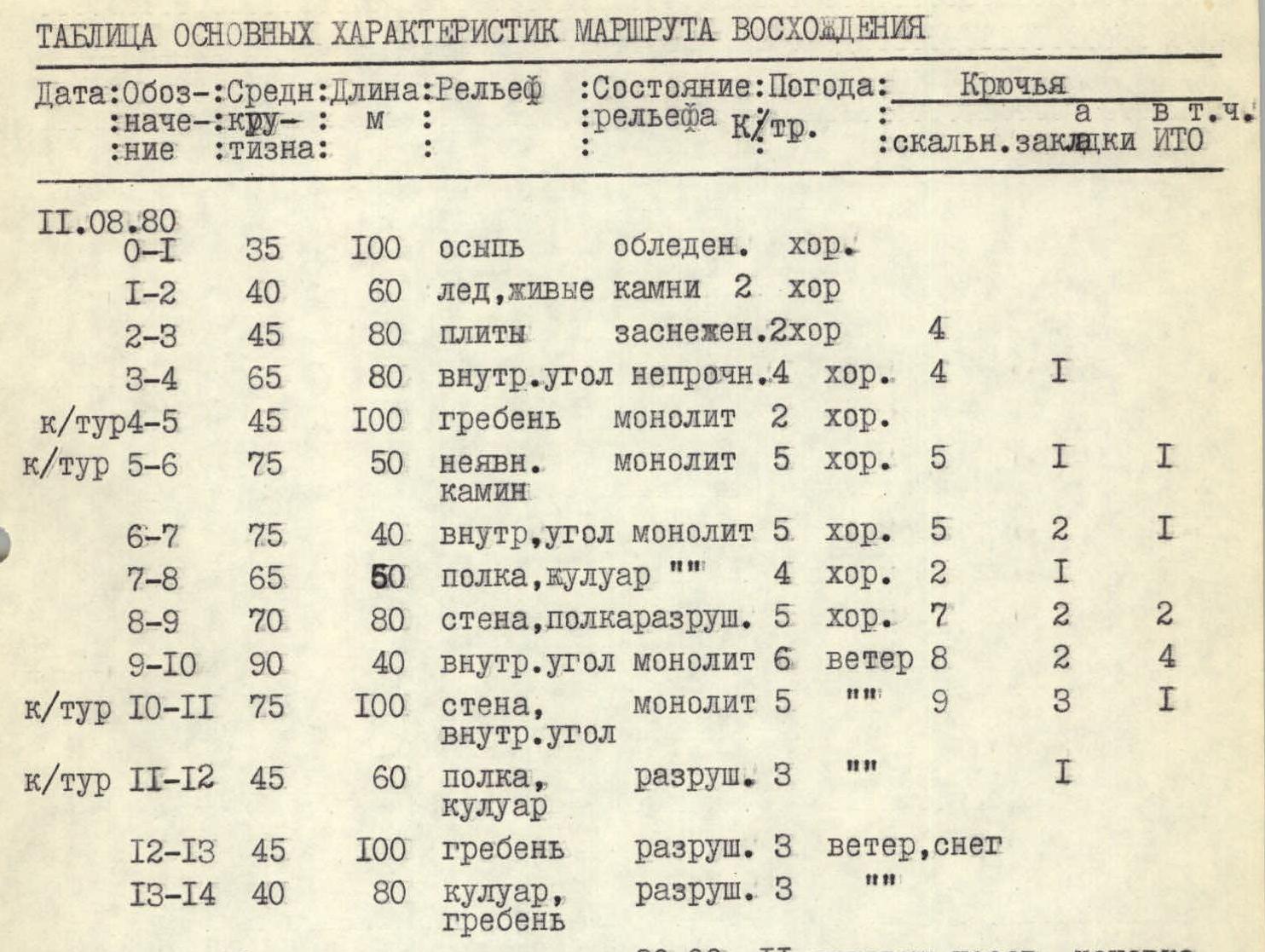
| Date:Designation | Avg. Steepness | Length | Terrain | Condition | Weather | Rock Pitons | Nut Pitons | incl. ASP |
|---|---|---|---|---|---|---|---|---|
| August 11, 1980 | ||||||||
| R0–R1 | 35° | 100 m | Talus | Icy | Good | |||
| R1–R2 | 40° | 60 m | Ice, loose rocks | Good 2 | ||||
| R2–R3 | 45° | 80 m | Slabs | Snowy | Good 2 | 4 | ||
| R3–R4 | 65° | 80 m | Internal corner | Unstable | Good 4 | 4 | 1 | |
| Control cairn 4-5 | 45° | 100 m | Ridge | Monolithic | Good 2 | |||
| Control cairn 5-6 | 75° | 50 m | Hidden chimney | Monolithic | Good 5 | 5 | 1 | 1 |
| R6–R7 | 75° | 40 m | Internal corner | Monolithic | Good 5 | 5 | 2 | 1 |
| R7–R8 | 65° | 50 m | Ledge, couloir | Good 4 | 2 | 1 | ||
| R8–R9 | 70° | 80 m | Wall, ledge | Destroyed 5 | Good 7 | 7 | 2 | 2 |
| R9–R10 | 90° | 40 m | Internal corner | Monolithic 6 | Windy | 8 | 2 | 4 |
| Control cairn 10-11 | 75° | 100 m | Wall, internal corner | Monolithic 5 | 9 | 3 | 1 | |
| Control cairn 11-12 | 45° | 60 m | Ledge, couloir | Destroyed 3 | 1 | |||
| R12–R13 | 45° | 100 m | Ridge | Destroyed 3 | Windy, snow | |||
| R13–R14 | 40° | 80 m | Couloir, ridge | Destroyed 3 |
Departure at 8:00, camped at 20:00, 11 hours of climbing, reclining camp.
August 12, 1980

| Date:Designation | Avg. Steepness | Length | Terrain | Condition | Weather | Rock Pitons | Nut Pitons | incl. ASP |
|---|---|---|---|---|---|---|---|---|
| R14–R15 | 50° | 100 m | Slope | Snowy 3 | Snow, wind | 2 | ||
| R15–R16 | 50° | 150 m | Couloir, internal corner | Snow, wind 3 | 2 | |||
| R16–R17 | 40° | 200 m | Ridge | Snow, rocks 2 | Snow, wind |
Departure at 9:30, arrived at camp at 17:20. Eight hours of climbing. During the glacier descent — sport descent 80 m, 1 ice screw. Route length 1500 m, average steepness 50°, sections of 5–6 category — 310 m, pitons driven: rock — 44, ice — 1, nuts — 13, total — 58, including for ASP — 9. The route was completed in 21.5 hours of climbing from the base camp; from the foot to the summit — in 12.5 hours.
Comments
Sign in to leave a comment