
Protocol No. 398, January 15, 1975 Report On the ascent to the summit "Podvodnaya Lodka" (5079 m) (approximately category 3B) by a group of climbers from the MAI sports club.
The summit "Podvodnaya Lodka" is located in the Central Pamir region, in one of the northern spurs of the Peter the First ridge.
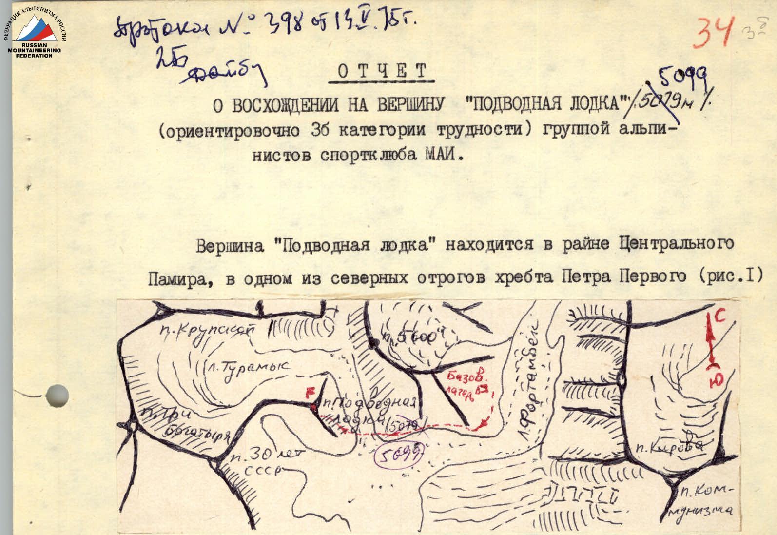
Fig. I, ascent scheme.
From a sporting perspective, the summit may be of interest for initial acclimatization climbs with the aim of gradual, gentle adaptation to high altitude.
Characteristic features of this route, as well as the entire region:
- Unstable rock formations
- Unstable weather
From the base camp on Suloev plain, follow the trail along the moraine of the glacier. Travel time is 1 hour. Cross the Turamys glacier and approach the rocky counterfort of "Podvodnaya Lodka" (Fig. 2, 3). Then ascend the counterfort. Steepness is 30–40°. Insurance through ledges. Movement is alternating and simultaneous. Several walls, 4 to 8 m high, are encountered along the way. The walls are overcome directly. Insurance is with pitons. After 2.5–3 hours, reach the saddle. Towards the end of the path, movement is on snow. Bypass the rocky "balda" on the left, with caution, as live rocks are possible.
Then ascend a very steep slope. Steepness up to 60°:
- Rocks are fragile, covered with snow.
- 5 ropes.
- Insurance through ledges and ice axe.
- Alternating movement.
Reach the pre-summit ridge. Then 2 ropes on steep snow to the summit. From the saddle to the summit is 4 hours. Descent is via the ascent route.
Compiled by: NAZAROV I.
Table of main characteristics of the ascent route Ascent route: Traverse: peak Oshanina (6305), peak V. Oshanina (6390) – peak V. Oshanina (6310) – peak 30 let Sovetskogo gosudarstva (6447) – peak Moskva (6785).
| Date | Sections traversed | Average steepness of section | Length in meters | Characteristics of section by relief | Cat. difficulty | By method of overcoming and insurance | Weather conditions | Time of arrival at bivouac | Time of walking hours | Pitons driven, rocky | Pitons driven, ice | Pitons driven, shlumber | Conditions of overnight stay |
|---|---|---|---|---|---|---|---|---|---|---|---|---|---|
| July 18 | R0–R1 | 50° | 300 m | Rocky bastion | 4 | Climbing, piton insurance | Cloudiness | 6:00 | 10 hours | 5 | 2 | On Shini Bini col 5100 | |
| R1–R2 | 40° | 300 m | Snow-ice slope | 4 | Alternating, piton insurance | Cloudiness | 9:00 | 10 hours | 2 | On western ridge below peak Zap. Oshanina 6150 | |||
| R2–R3 | 35° | 500 m | Icefall | 4 | 3 | ||||||||
| R3–R4 | 45° | 700 m | Snow-ice slopes | 4 | 4 | ||||||||
| R4–R5 | 60° | 120 m | Pre-summit tower with icy rocks | 5 | Alternating, piton insurance | Clear, strong wind | 9:00 | 11 hours | 4 | Platform on cut cornice 6100 | |||
| R5–R6 | 40° | 450 m | Snow slope | 4 | |||||||||
| R6–R7 | 45° | 600 m | Traverse of snow-ice slope | 5 | 5 | ||||||||
| R7–R8 | 55° | 250 m | Ridge with sheer walls and cornices | 5 | 5 | ||||||||
| R8–R9 | 80° | 120 m | Icy rock wall | 5 | Alternating, first without backpack, piton insurance | Cloudless | 9:30 | 10 hours | 10 | On ridge behind peak Ts.Oshanina 6300 | |||
| R9–R10 | 35° | 250 m | Snow-ice slope | 5 | 3 | 2 | |||||||
| July 24 | R10–R11 | 45° | 500 m | Traverse of snow-ice slopes | 5 | Variable cloudiness, Wind | 9:00 | 10 hours | 5 | On ridge behind peak V.Oshanina 6250 | |||
| R11–R12 | 50° | 300 m | Snow-ice slopes | 5 | 8 | ||||||||
| July 23 | R12–R13 | 60° | 250 m | Snow-ice rocks | 5 | Rappelling, sports, piton insurance | Variable cloudiness, Strong Wind | 9:00 | 9 hours | 9 | 6 | Cut out platform in ice on col 6000 | |
| R13–R14 | 45° | 300 m | Snow-ice slopes | 5 | 4 | ||||||||
| July 22 | R14–R15 | 50° | 400 m | Traverse ascent on snow-ice slopes | 5 | Alternating, piton insurance | Cloudiness, snowstorm | 9:00 | 10 hours | 3 | 8 | On northern ridge of peak 30 let Sov. Gosudarstva | |
| R15–R16 | 80° | 200 m | Snow-covered rocks and walls | 5 | 5 | 3 | |||||||
| R16–R17 | Overhanging | 3 m | Snow-ice cornice | 5 | 4 | ||||||||
| July 21 | R17–R18 | 35° | 400 m | Snow slope | 4 | Alternating, without backpack, piton insurance | Cloudless, Strong Wind | 10:00 | 8 hours | 12 | On col 6000 | ||
| R18–R19 | 40° | 800 m | Descent on snow-ice slope | 5 | |||||||||
| July 20 | R19–R20 | 45° | 600 m | Snow-ice slopes | 5 | Alternating, piton insurance | Cloudiness, Wind | 9:00 | 11 hours | 10 | On col 6000 | ||
| R20–R21 | 60° | 70 m | Icy rock wall | 5 | 3 | 2 | |||||||
| R21–R22 | 60° | 100 m | Snow-ice slope | 5 | 5 | ||||||||
| R22–R23 | 70° | 40 m | Rocky chimney | 5 | 2 | ||||||||
| R23–R24 | 40° | 1500 m | Snow-ice slope and ridge | 5 | 4 | 4 | |||||||
| July 25 | R24–R19 | Descent via ascent route | 5 | ||||||||||
| July 26 | 45° | 2500 m | Descent via icefalls to col between peak Moskva and peak 30 let Gosudarstva on Satran glacier | 5 | Rappelling, sports, piton insurance | Variable cloudiness | 9:00 | 11 hours | 13 | On Satran glacier 4200 |
Team captain (V. Khomutov) Team coach (Yu. Borodukhin)
TABLE OF MAIN CHARACTERISTICS OF THE ASCENT ROUTE Ascent route to peak "Podvodnaya Lodka"
| Characteristics of section | and passage conditions |
|---|---|
| TABLE OF MAIN CHARACTERISTICS OF THE ASCENT ROUTE | |
| Ascent route to peak | "Podvodnaya Lodka" |
| Date | Passage of section | Average steepness of section | Passage length | By relief characteristics | Cat. difficulty | By method of movement and insurance | Weather conditions | Time of stop at bivouac, departure, walking hours | Pitons driven, rocky | Pitons driven, ice | Pitons driven, shlumber | Conditions of overnight stay |
|---|---|---|---|---|---|---|---|---|---|---|---|---|
| July 26, 1975 | R1 | 3–5° | 3 km | Scree, moraine, glacier | 1 | In crampons | Clear | Departure from base camp at 5:30 | 1 | Overnight stay in base camp | ||
| -"- | R2 | 30–40° | 2 km | Rocks | 3 | Ropes, insurance through ledges and pitons | Cumulus clouds | Arrival at rocks at 6:45 | 2 | |||
| -"- | R3 | 8–10° | 0.3 km | Snow | 1 | Insurance with ice axe | -"- | Arrival at shelf at 9:00 | -"- | |||
| -"- | R4 | 40–60° | 0.4 km | Snow, rocks | 3 | Through pitons | Cloudy | Arrival at rocks at 9:40 | 2 | -"- | ||
| -"- | R5 | Descent via ascent route |
Comments
Sign in to leave a comment