Ascent Log
I. Ascent category: high-altitude technical (up to 6500 m)
-
Ascent area: North-Western, Pamir, l. Garmo
-
Ascent route indicating peaks and their heights: South-West wall of p. Kuibyshev, 6198 m
-
Ascent characteristics: height difference — 1560 m, average steepness — 68.5°, length of complex section — 485 m
-
Pitons driven: rock — 178, ice — 16, bolt — —
-
Number of travel hours — 53 h
-
Number of bivouacs and their characteristics: four, all sitting
-
Team name: Central Asian Military District (CAMD)
-
Surname, name, patronymic of the leader, participants and their sports qualification:
POLONOV Vladimir Georgievich, MS. POPENKO Yuri Stepanovich, MS. ZOLOTAREV Vladimir Pavlovich, MS. SILCHENKO Vasily Petrovich, CMS — performed 10. Team coach: ILYINSKY E.T., MS, Honored Coach of the Kazakh SSR
II. Dates of departure and return:
August 12, 1977 August 16, 1977
Route Description
August 10, 1977
At 14:00, the assault group along with observers G. Volynets and V. Knyazev left the base camp located at Grushinsky bivouacs. At 17:00, the group approached the beginning of the river ridge v. Kroshka, where they set up an observer's camp. The rest of the day was used to set up the "Nedra-P" radio station, and at the scheduled time — 19:00 — a radio session took place between the observers and the base camp.
August 11, 1977
Day of approach and processing. The assault group left the observer's camp and, having overcome the icefall to the left, in 4 hours approached the wall. At 19:00, the pair Popenko — Silchenko started processing the route from a bivouac set up on the glacier under the wall, and followed an ice-firn slope with a steepness of 50–55° to the bergschrund. The height difference between the upper and lower edges of the bergschrund is 10 m (section 1). The route begins to the right of two gullies cut in the ice couloir, with a cross-section of 1.5 × 1.5 m. Having overcome the bergschrund in crampons with the use of ice axes, the pair entered an ice slope with a steepness of 60°, along which the ascent continues to the beginning of the rock mass (section 2). By 22:00, having processed the bergschrund and a section of the ice slope about 90 m long, the pair began their descent.
August 12, 1977
Departure from the bivouac on the glacier under the wall at 7:00. V. Silchenko works first. Having overcome the bergschrund and the ice slope, at 10:00, the entire group enters the rocks. When passing the remaining 70-meter ice slope, not processed in the evening, crampons are used. The beginning of the rock mass is a wall with a steepness of 60°, composed of curved slabs (section 4). The rocks are dry, so the first works in galoshes. After 200 m, the wall's steepness increases to 70°, and the slabs are replaced by "tiles" (section 5). The rocks in this section are fragile, so mainly pitons longer than 150 mm are used for belaying. The length of the section is 130 m. Next is a sheer wall 10 m high (section 6). Above the wall, under a rock overhang, there is a narrow inclined ledge, where a sitting bivouac is arranged. The lead pair processes the further path. Again, tile-like rocks with an overall steepness of 65° (section 7). Having climbed 100 m, the pair finishes processing.
August 13, 1977
The V. Zolotarev — V. Polonov team leads. Entry at 9:00. After the processed section, the terrain character remains unchanged for another 20 m (section 8). Then, a monolithic sheer wall 30 m high begins (section 9), leading to a rock ridge with a steepness of 75° and a length of 40 m (section 10). On section 9, rockfall is pulled out. Further, with great caution, an inner corner with "live" rocks is overcome. The steepness of the corner is 65°, the length is 40 m (section 11). Behind the corner is a 60° ice slope 30 m long (section 12), which is overcome in crampons. The slope leads to a jagged rock wall with a steepness of 75° and a length of 30 m (section 13). At the top of the wall, there is a narrow ledge, where the second sitting bivouac is arranged. Above the wall, an ice slope with a steepness of 60° continues (section 14), leading through 60 m to a sheer rock bastion. The lead pair finishes the day by processing this ice slope.
August 14, 1977
The V. Polonov — V. Zolotarev pair leads. The first section of the day is a 30-meter wall of the rock bastion with a steepness of more than 90° (section 15). On the wall, we leave the 1st control point — note №8. Climbing is difficult; ladders are used, rockfall is pulled out. The wall continues upwards for another 40 m, but its steepness is now 75°. The rocks are wet (section 16). Next is an almost horizontal traverse to the right 60 m along a narrow inclined ledge with ice accretion (section 17), followed by a vertical ascent first along a sheer wall 20 m high (section 18), and then 40 m along the right side of an inner corner with a steepness of 70° (section 19). On the last two sections, we exercise special caution, as the rocks are heavily destroyed. After the inner corner, there is a 100-meter monolithic wall with a steepness of 75° (section 20). The rocks are partially covered with ice. The wall leads to a 10-meter smooth sheer drop (section 21), where we pull up the rockfall and immediately arrange the third sitting bivouac on a ledge under a rock overhang. The bivouac is in plain sight of the base camp, and during the evening radio session, we exchange information with both the observers and the "Base". From the bivouac, a 10-meter rock wall with a steepness of 70°, completely covered with ice accretion, is processed upwards to the right (section 22).
August 15, 1977
We leave the second control tour on the bivouac. V. Zolotarev works first today. After the wall, there is an ice slope 40 m long with a steepness of 55° (section 23), followed by a traverse of the couloir to the right and upwards 30 m (section 24) with an exit to a ridge leading to the summit tower. The rocks of the couloir are covered with patch ice. The steepness of the ridge is 75°, the length is 140 m (section 25), the rocks are tile-like, with many "live" stones. The ridge is interrupted by a sheer wall 10 m high (section 26). Behind the wall, the ridge continues for another 90 m (section 27) and approaches the base of the summit tower with a snow-ice ridge 10 m long (section 28). Under the tower is the fourth sitting bivouac, this time the last on the route. The pair processes a 70-meter section above the bivouac (section 29). The wall of the summit tower is composed of large blocks, its overall steepness is more than 85°. By evening, the weather deteriorated, and snowfall began at night.
August 16, 1977
In the morning, the weather did not improve, visibility was limited, and snowfall continued. V. Silchenko is the first on the route. Passing complex steep sections of the summit tower is complicated by snowfall and limited visibility. The overall height of the tower is about 250 m, 70 of which were processed at the end of the previous day. We pull up rockfall twice during the day, and by 17:00, we reach the upper edge of the rocks — section 30 is passed. Further to the summit, we go along a snow slope 120 m long with a steepness of 30°, the snow is dense, belaying through ice axes (section 31). On the summit and in the nearby rocks, we did not find a control tour, so we built our own in the uppermost rock outcrop to the south of the summit. The third intermediate control tour — a gasoline can — was left in the lower part of the summit tower. The weather did not improve by evening, so we could not capture a panorama of the peaks surrounding p. Kuibyshev on film. We began our descent at 16:00 along the ridge towards v. Kroshka. We descended onto the plateau in the twilight.
August 17, 1977
In the morning, the weather is excellent. Further descent proceeds from the saddle between p. Kuibyshev and v. Kroshka onto the Kroshka glacier. In 7 hours, the entire group safely reaches the glacier. The descent is carried out on a double rope with subsequent pulling through. Overnight stay at the initial bivouac site under the already passed wall of p. Kuibyshev.
August 18, 1977
At 12:00, the team descended to the observer's camp, and at 17:00, together with the observers, returned to the base camp.
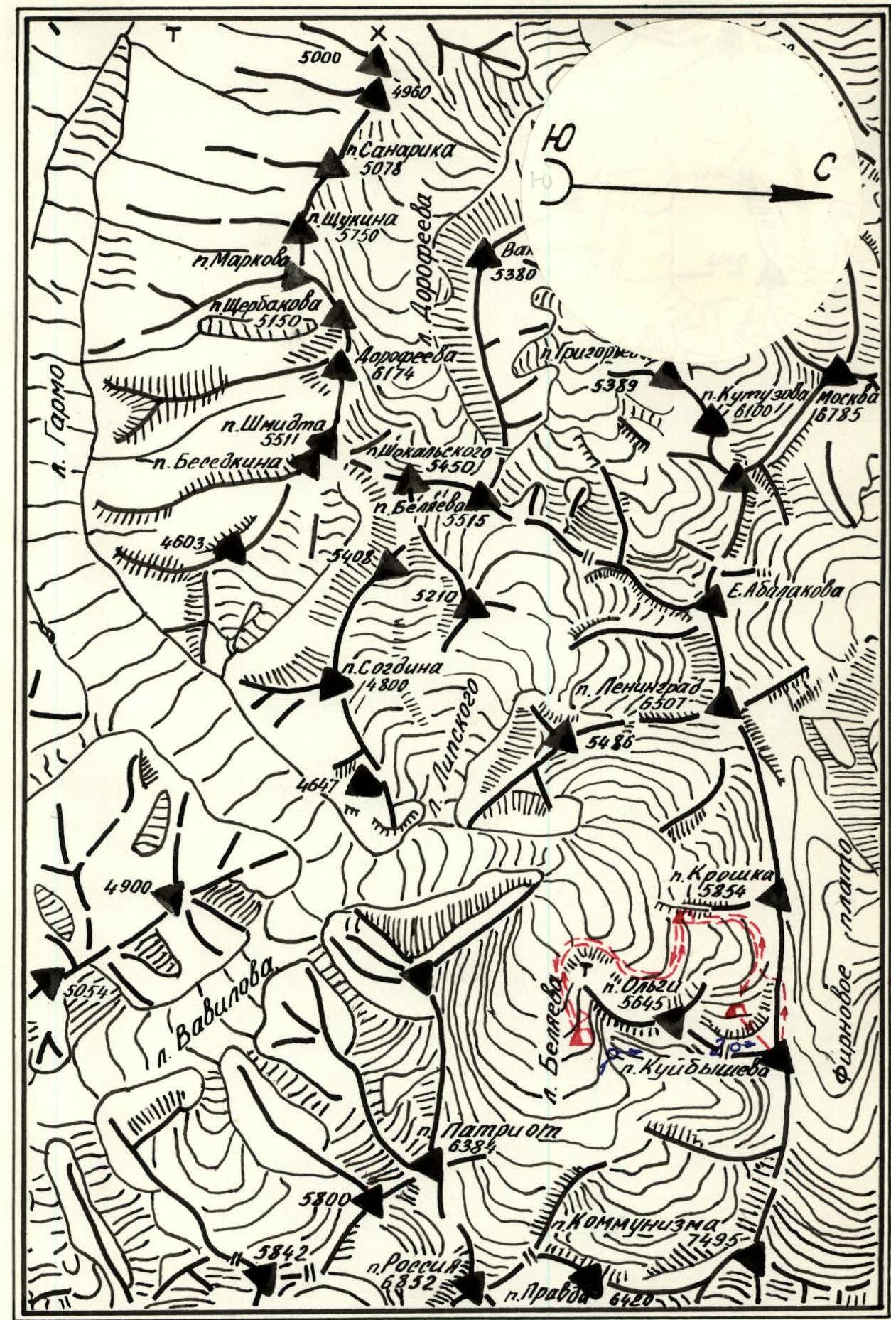
Orographic scheme of the ascent area. Legends: Б Base camp. • Observation point and overnight stay under the wall. 10 Points for shooting the wall profile.
7. Table of Main Characteristics of the Ascent Route
Ascent route: South-West wall of Peak Kuibyshev (6198 m).
| Date | Passed sections | Average steepness of section, ° | Length of section, m | Characteristics of section and passage conditions (by terrain type) | Difficulty category | By method of passage and belaying | By weather conditions | Time of bivouac, departure, travel hours | Pitons driven: rock | Pitons driven: ice | Pitons driven: bolt | Bivouac conditions |
|---|---|---|---|---|---|---|---|---|---|---|---|---|
| ІІ August | 1 | 85–90 | 10 | Bergschrund | 5Б | On crampons with ladders, piton belay | Good weather | 22:00 19:00 3:00 | 2 | Comfortable on glacier under route | ||
| 2 | 60 | 90 | Ice slope, местами кальгаспоры | 4Б | On crampons, местами рубка ступеней, крючьевая | – | 4 | |||||
| 12 August | Passed processed August 11 sections of the route (1 and 2) | |||||||||||
| 3 | April | 60 | 70 | Ice slope, местами кальгаспоры | 4Б | On crampons, местами рубка ступеней, крючьевая | Good weather | 19:00 7:00 12:00 | 3 | |||
| 4 | 60 | 200 | Rock wall, сложенная плитами, скалы не прочные | 4Б | Climbing in galoshes, piton belay, ledges | 15 | ||||||
| 5 | 70 | 130 | Wall with tile-like rocks | 5А | – | 9 | ||||||
| 6 | 85–90 | 10 | Monolithic wall with few holds | 6 | Climbing in galoshes, with ladders, piton belay | 3 | sitting, uncomfortable | |||||
| 7 | 65 | 100 | Rock wall, tile-like rocks | 4Б | Climbing in galoshes, piton belay, ledges | 13 | ||||||
| 13 August | Passed processed August 12 section of the route (7) | |||||||||||
| 8 | 65 | 20 | Rock wall, tile-like rocks | 4Б | Climbing in galoshes, piton belay, ledges | Good weather | 19:00 9:00 10:00 | 3 | ||||
| 9 | 90 | 30 | Rock wall with few holds | 6 | Climbing in galoshes with ladders, piton belay | 7 | ||||||
| 10 | 75 | 40 | Rock ridge with strong monolithic rocks | 5Б | Climbing in galoshes, piton belay, ledges, with ladders | Good weather | 5 | |||||
| 11 | 65 | 40 | Inner corner with "live" stones | 4А | Climbing in galoshes, piton belay, ledges | – | 4 | sitting, uncomfortable | ||||
| 12 | 60 | 30 | Ice slope | 4Б | On crampons, piton belay | 2 | ||||||
| 13 | 75 | 30 | Rock wall with tile-like rocks and narrow ledges | 5А | Climbing in galoshes, piton belay, ledges | 2 | ||||||
| 14 | 60 | 60 | Ice slope, ноздреватый лёд | 4А | On crampons, piton belay | 3 | ||||||
| 14 August | Passed processed August 13 section of the route (14) | 19:30 9:00 10:30 | ||||||||||
| 15 | более 90 | 30 | Negative rock wall with few holds | 6 | Climbing in galoshes with ladders, piton belay | Good weather | 16 | |||||
| 16 | 75 | 40 | Rock wall with wet rocks | 5Б | Climbing in crampons, piton belay | 7 | ||||||
| 17 | 10 | 60 | Narrow inclined ledge with ice accretion | 3А | Climbing in crampons, ledges, piton belay | 3 | ||||||
| 18 | 90 | 20 | Rock wall with destroyed rocks and few holds | 6 | Climbing in galoshes with ladders | 8 | ||||||
| 19 | 70 | 40 | Inner corner with destroyed rocks | 4Б | Climbing in galoshes, piton belay, ledges | 5 | ||||||
| 20 | 75 | 100 | Rock wall, rocks covered with ice accretion | 5Б | Climbing in crampons, piton belay, ledges | 16 | ||||||
| 21 | 85–90 | 10 | Monolithic rock wall with few holds, covered with ice accretion | 5Б | Climbing in crampons with ladders, piton belay | 5 | sitting, uncomfortable | |||||
| 15 August | Passed processed August 14 section of the route (22) | |||||||||||
| 22 | 70 | 10 | Monolithic rock wall with few holds, covered with ice accretion | 5Б | Climbing in crampons, piton belay, ledges | 3 | ||||||
| 23 | 55 | 40 | Ice slope | 3Б | On crampons, piton belay | Good weather | 19:00 9:30 9:30 | 2 | ||||
| 24 | 20 | 30 | Couloir, rocks with patch ice | 3А | Climbing in crampons, piton belay, ledges | 3 | ||||||
| 25 | 75 | 140 | Rock ridge, rocks tile-like, some "live" stones | 4Б | Climbing in crampons, piton belay, ledges | 17 | ||||||
| 26 | 90 | 10 | Smooth rock wall without holds | 6 | Climbing in galoshes with ladders, piton belay | 4 | ||||||
| 27 | 75 | 90 | Rock ridge composed of blocks, rocks monolithic, few holds | 5Б | Climbing in crampons, piton belay, ledges | Weather worsening | 8 | |||||
| 28 | 20 | 10 | Snow-ice sharp ridge | 3А | Climbing in crampons, piton belay | 1 | ||||||
| 29 | 85–90 | 75 | Rock wall, сложенная из крупных блоков | 5Б | Climbing in crampons, местами применяются лесенки, крючьевая, выступы | Bad weather, snowfall | 8 | sitting, uncomfortable | ||||
| 16 August | Passed processed August 15 section of the route (29) | 18:00 10:00 8:00 | ||||||||||
| 30 | 85–90 | 120 | Rock wall, сложенная из крупных блоков | 5Б | Climbing in crampons, with ladders, piton belay, ledges | Bad weather, snowfall | 13 | |||||
| 31 | 30 | 120 | Snow slope, dense snow | 2Б | Climbing in crampons, through ice axe | – |
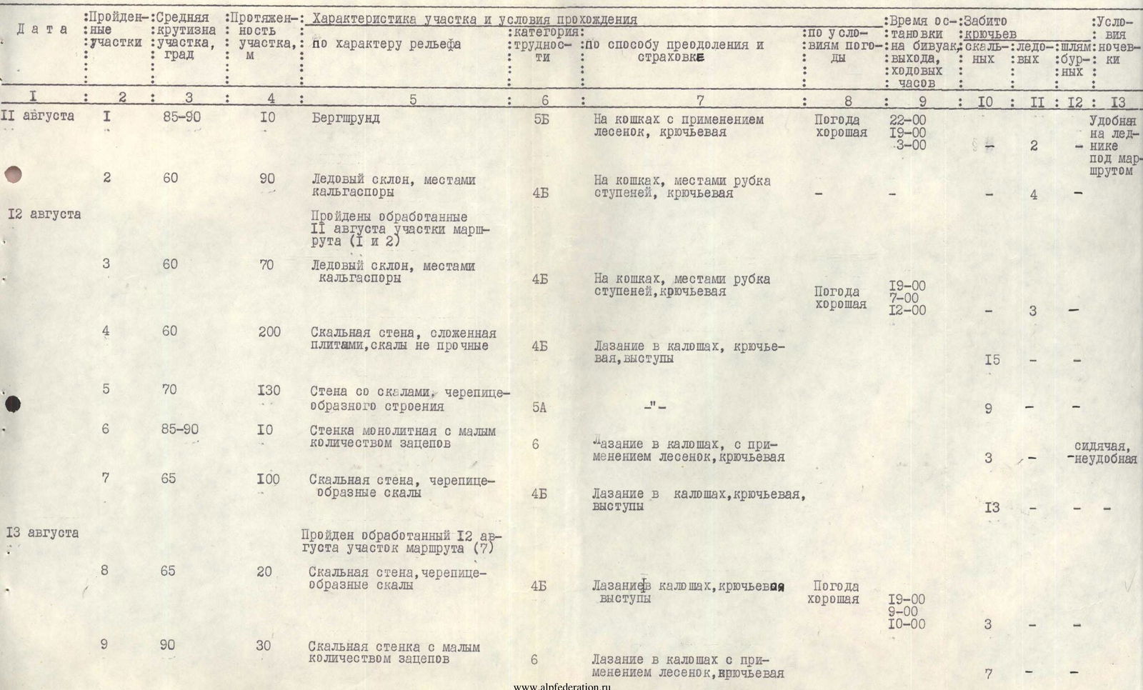
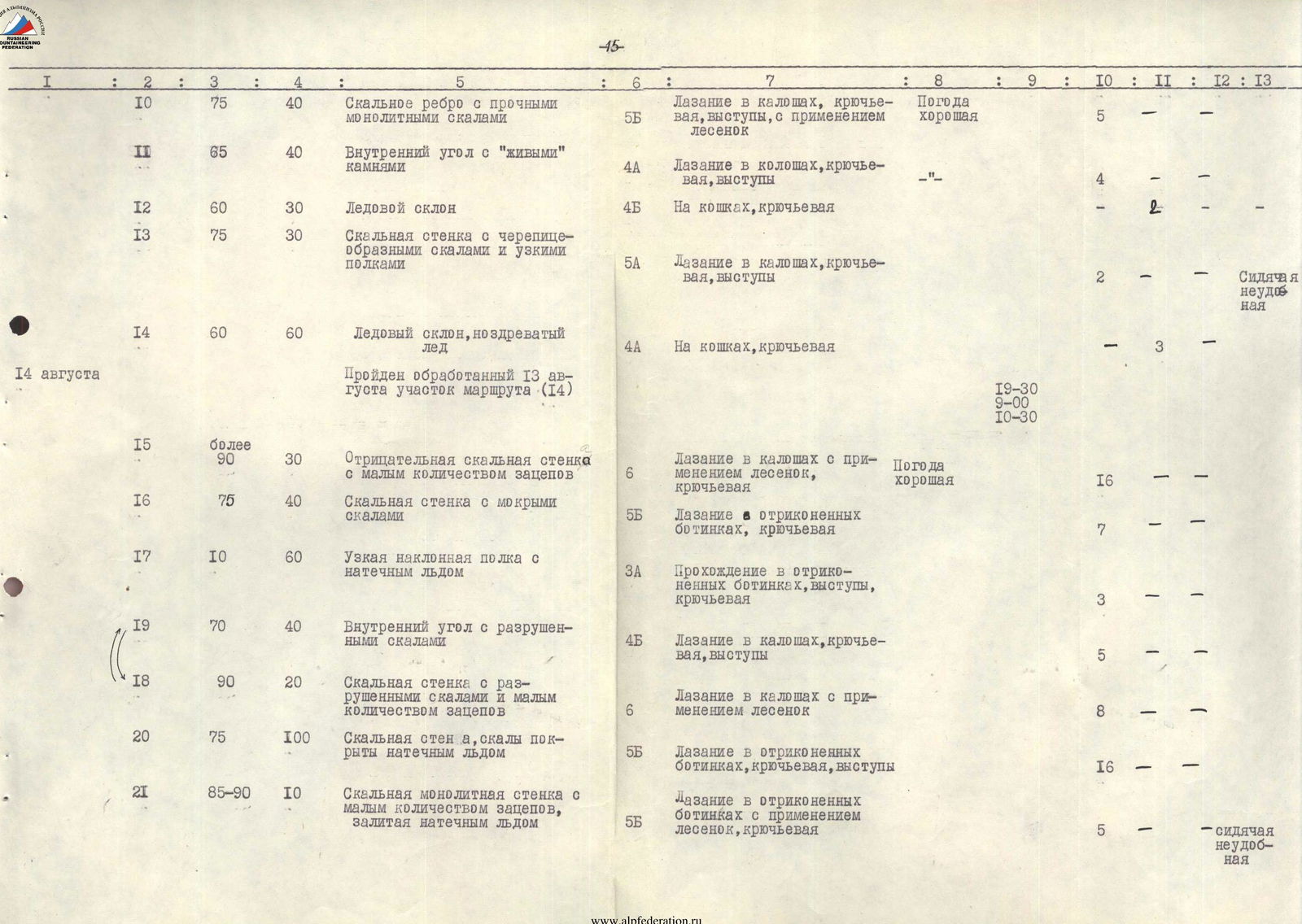
NOTE:
- The number of travel hours was determined by the time worked by the first on the route.
- In columns 10, 11, 12, the number of pitons is indicated for the sections as a whole.
- In column 13, the characteristics of bivouacs are given against the sections of the route, at the level of which they were organized.
Team coach: E. ILYINSKY Team captain: V. POLONOV
Photo 1. General view
... Path K. Kuzmin
C.T. — control tour
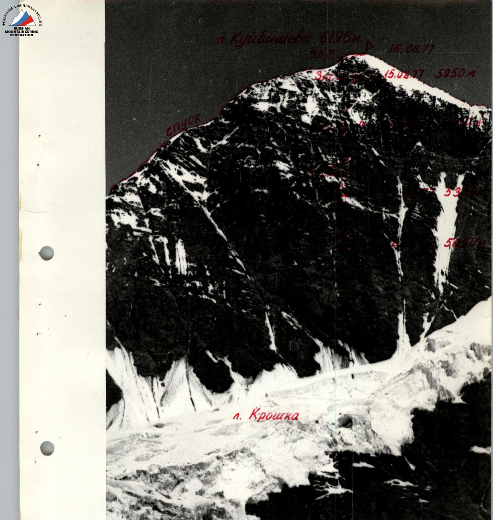
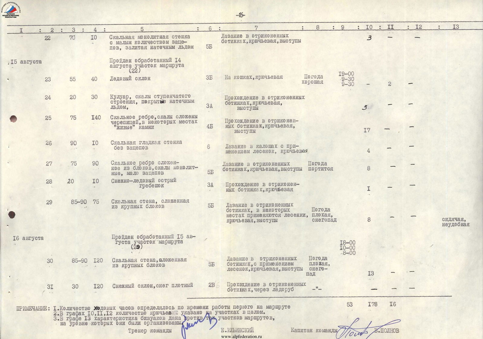
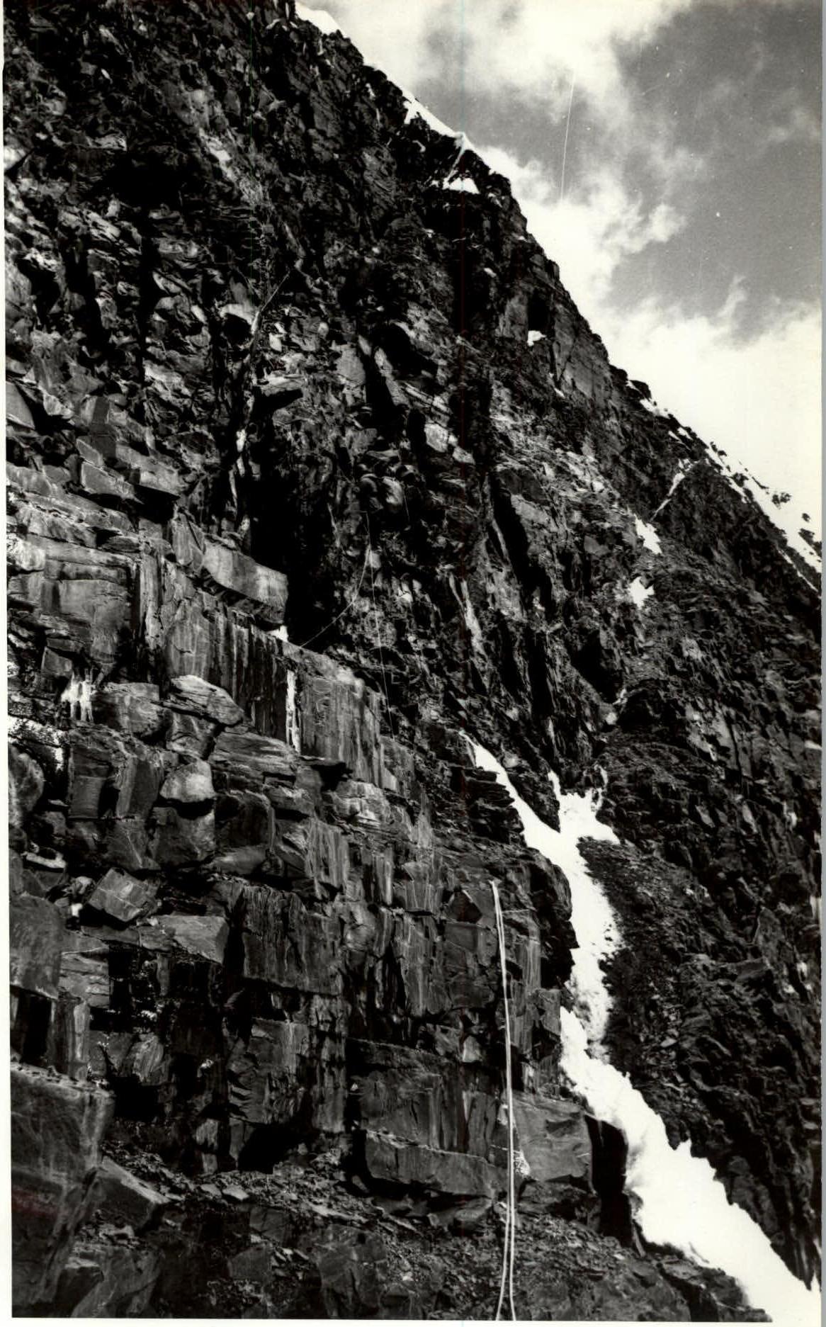
Photo 5. Section 4
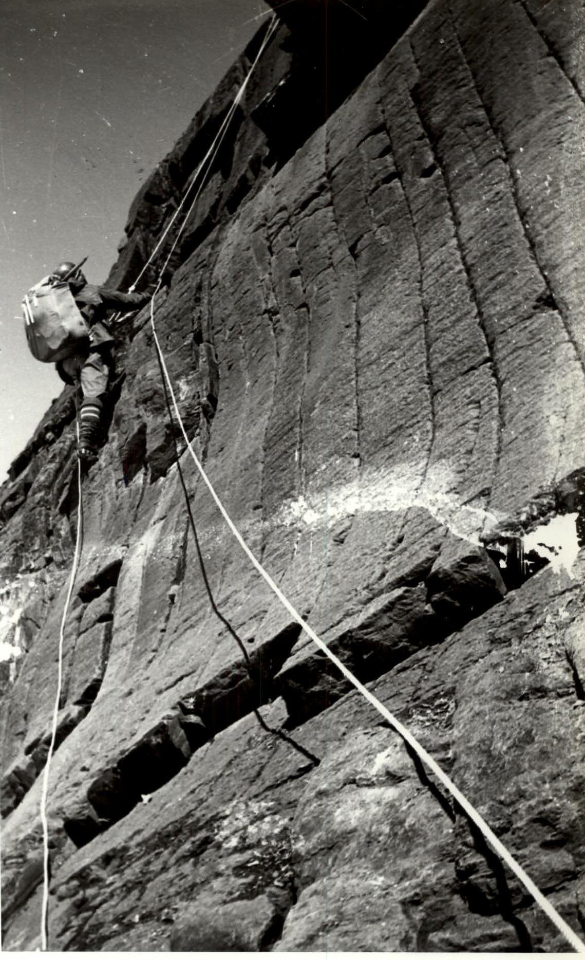
Photo 4. Profile of the wall
Taken from the saddle between p. Kuibyshev and p. Olga. Year of shooting 1976.
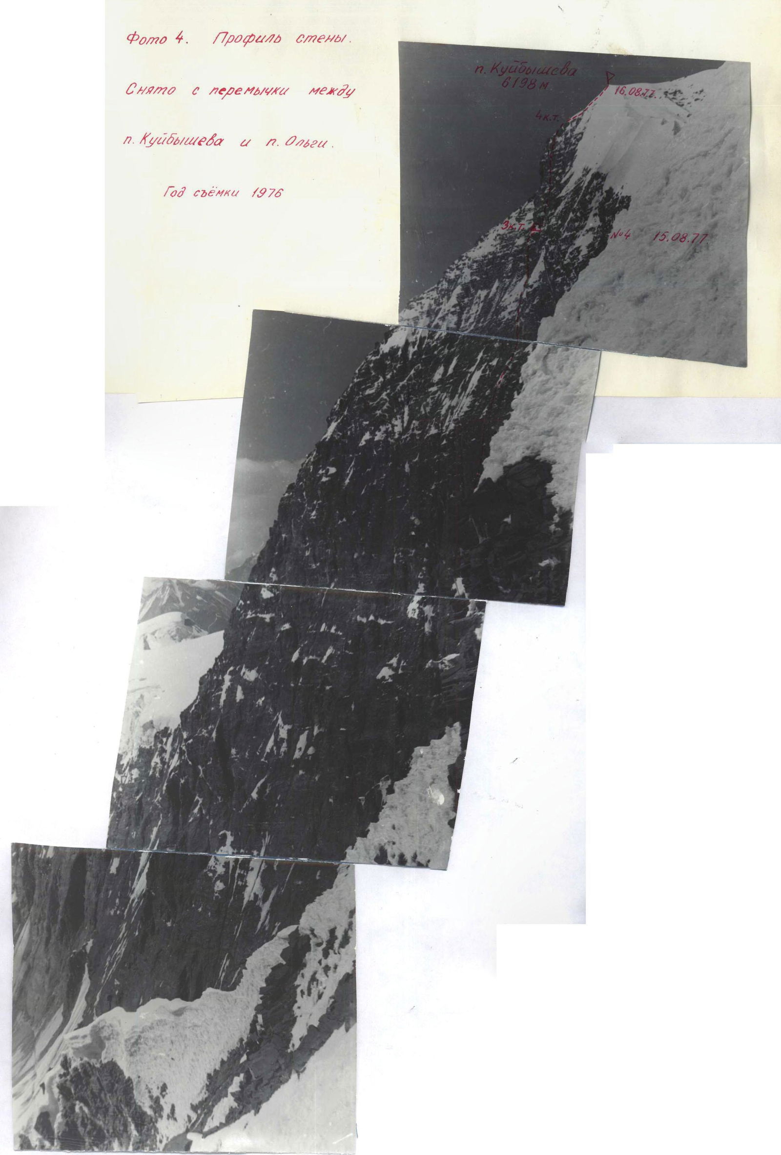
Photo 6. Section 5
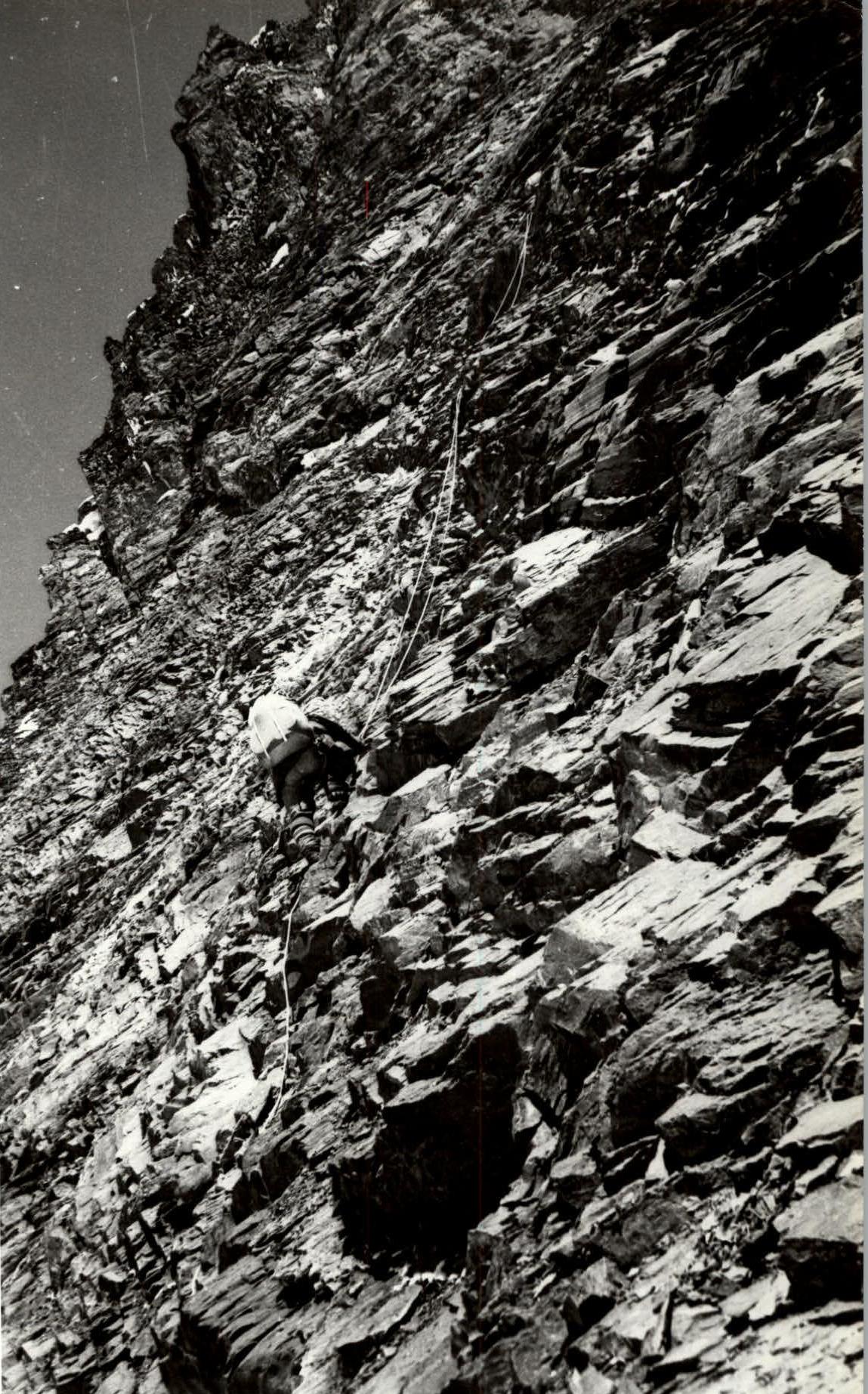
Photo 15. Section 19