
Peak Krupskaya (6008 m), via the Southeast Ridge, mixed terrain, from Turamys Glacier.
The ascent was made on July 12–14, 1974, by a group from the MAI training camp "Vysochnik" led by V.A. Shuvаlov.
Group Members
- Shuvаlov V.A. — 1st sports category — leader
- Nazarov I.V. — participant
- Komkov V.M. — participant
- Plotkin V.V. — participant
Description compiled by:
V.A. Shuvаlov
I. Geographical Location and Sporting Characteristics of the Object
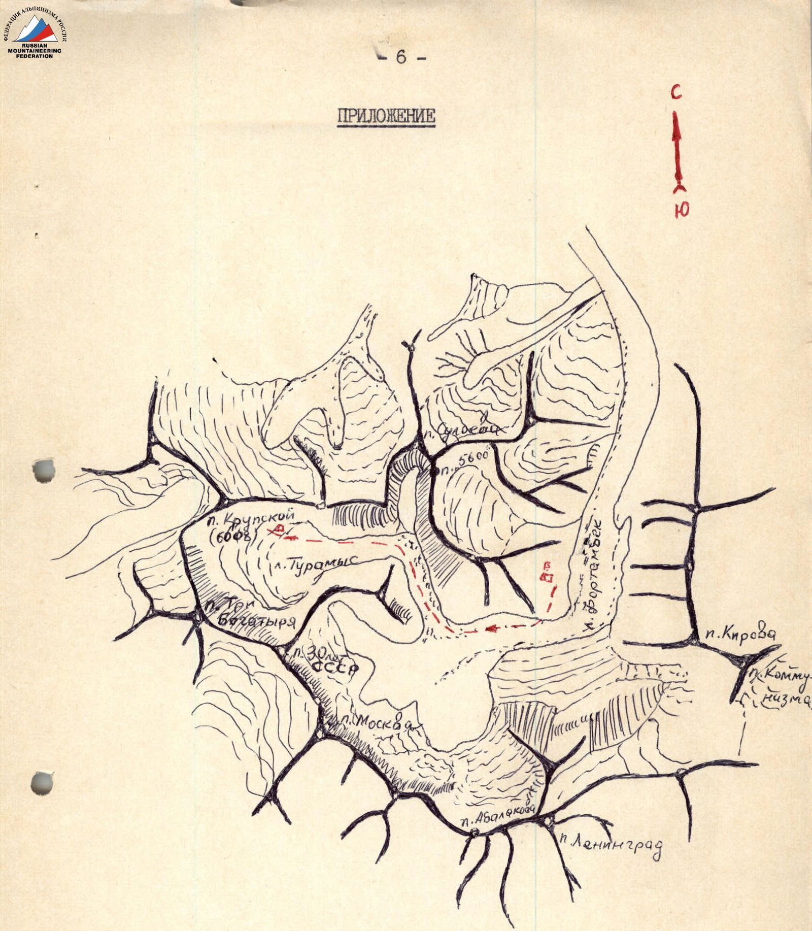
Peak Krupskaya, with an elevation of 6008 m, is located in the Central Pamir region near Peak Communism, Fortambek Glacier, and Turamys Glacier. From Peak Communism, a powerful ridge extends initially southwest and then turns northwest, featuring peaks such as:
- Moskva
- 30 Years of Soviet Power
- Three Robbers
Parallel to this ridge and to the north lies a lower ridge that includes Peak Krupskaya. Both ridges converge near the Shini-Bini pass, forming the Turamys Glacier cirque (Fig. 1).
Until 1974, there were no classified routes on Peak Krupskaya, although a group led by K. Kuzmin ascended this peak in 1957. The group did not leave a description of their ascent. From Turamys Glacier, routes can be laid up the southern slope and southeast ridge, which would be of considerable interest as an intermediate acclimatization stage before tackling more complex ascents to peaks around 7000 m in the area.
2. Climbing Conditions in the Area
The meteorological conditions in the area are unfavorable. Cloud cover and precipitation are very common in the second half of the day. Westerly and southwesterly winds prevail. The peak is located in the upper reaches of Turamys Glacier, about 4–4.5 hours' walk from Suloyev meadow.
The Peak Krupskaya area is very cold and heavily snow-covered.
In the morning, the weather is typically good.
During the day, cloud cover develops, often significantly.
In the evening, snow and strong winds occur.
3. Route Description to Peak Krupskaya via the Southeast Ridge
The ascent to the summit from the base camp on Suloyev meadow took the climbers 3 days (July 12, 13, and 14).
A few days prior, several groups of climbers from MVTU had ascended Peak Krupskaya via the southern slope. Our task was to traverse the Southeast Ridge, about which nothing was known before our ascent. From Turamys Glacier, the ridge appears serrated with many gendarmes. The ridge slopes drop steeply (50–55°) towards the glacier (Fig. 2, 3).
The group set out for the ascent consisting of:
- Shuvаlov V.A. — 1st sports category — leader,
- Nazarov I.V. — participant,
- Komkov V.M. — participant,
- Plotkin V.V. — participant.
Below is a day-by-day description of the route.
-
Day 1 — July 12. From the base camp located on Suloyev meadow (Fortambek Glacier), we ascended the moraine of Turamys Glacier. Before reaching the icefall flowing from the cirque of Peak Suloyev, we transitioned onto Turamys Glacier. We then proceeded across the open glacier towards Shini-Bini pass. We exited the glacier onto the moraine where a stream on the right (in the direction of travel) merges with the glacier. From here, it was visible that the Southeast Ridge of Peak Krupskaya is flanked by gentle, talus-covered terraces. We camped here for the night.
-
Day 2 — July 13. Departure at 6:00. The first section (R0–R1) (Fig. 2, 3) presented no significant technical difficulties. We ascended with a gain in height towards a pronounced shoulder extending from the ridge. The shoulder was covered in ice and snow and dropped steeply towards Turamys Glacier. This shoulder transitions into a steep counterfort. We ascended the shoulder and climbed the counterfort. Initially, the snow slope was 25–30°; then we entered a rocky section. The journey from the campsite to the rocky outcrops took 3 hours.
The second section (R1–R2) was rocky. Here, steep (50–60°), unstable, and highly fractured rocks demanded significant attention. Protection was achieved through rock features. We climbed the rocks to a broad snow ledge and traversed left onto a steep ice slope (45–50°) covered with snow. We then traversed this slope, bypassing a large rock gendarme on the left, and reached the Southeast Ridge of Peak Krupskaya. Completing this section took 3 hours and 30 minutes.
The third section (R2–R3) was mixed, with rocky, snowy, and icy segments, following the ridge and presenting considerable technical challenges (Fig. 2, 3, 4). The southern slopes of the ridge were steep (70–80°) and dropped sharply onto Turamys Glacier with rocky outcrops. The northern slopes of the ridge were covered with a broken glacier concealed by snow. This section featured 8 rocky gendarmes. The first three gendarmes were bypassed on the right via the covered glacier. Caution was necessary here due to numerous crevasses. The fourth and fifth gendarmes were ascended directly via unstable rocks, with climbing rated at 3–4 category difficulty. The second rope used fixed ropes for protection. The sixth gendarme was bypassed on the left via rocks, approximately 4th category difficulty, with protection through rock features and pitons. In this area, it was necessary to use channel pitons for the rocky terrain.
The seventh and eighth gendarmes, particularly the last one, were the key features of the entire route. While the first three gendarmes took 0.5 hours to pass, and the next three took 1.5 hours, the last two gendarmes took 4 hours. The last gendarme alone took 3 hours to climb over three rope lengths.
The seventh gendarme was ascended directly via difficult rocks (climbing approximately 4–5 category difficulty). The second rope followed the fixed ropes. Two rock pitons were placed.
The eighth gendarme was ascended somewhat to the left via a nearly vertical ice slope. One ice screw and two rock pitons were placed. The rocks were of 5th category difficulty and very unstable. Fixed ropes were established.
After the eighth gendarme, we reached a snowy ridge. We camped here for the night.
The tent was conveniently positioned on:
- rocky ledges
- above the ridge drop to Turamys Glacier
This ledge offered some protection from the strong winds on the ridge. The elevation was approximately 5700 m above sea level.
- Day 3 — July 14. Departure at 6:15. The fourth section (R3–R4) was snowy and steep (45–50°). To the summit, there were 7–8 rope lengths, with protection through ice axe. The journey from the campsite to the bivouac took 2 hours and 30 minutes. At the base of the summit dome, there was a bergschrund. This section needed to be traversed early in the morning before the snow melted.
The fifth section (R4–R5) was the descent. We descended via the ascent route and then down the southern slope onto Turamys Glacier from the ridge. From the shoulder, half a rope length down the rocks to a snowy couloir, followed by four rope lengths of rappelling down to a clean snow slope, where we could either descend in three pitches or slide down to the glacier surface.
The ascent to Peak Krupskaya via the Southeast Ridge was rated by the group as a Category 5A route and can serve as a good training ascent before undertaking high-altitude and technically challenging routes in the area.
Ascent leader:
 V.A. Shuvаlov
Fig. 1. Area Diagram
Fig. 2. Peak Krupskaya
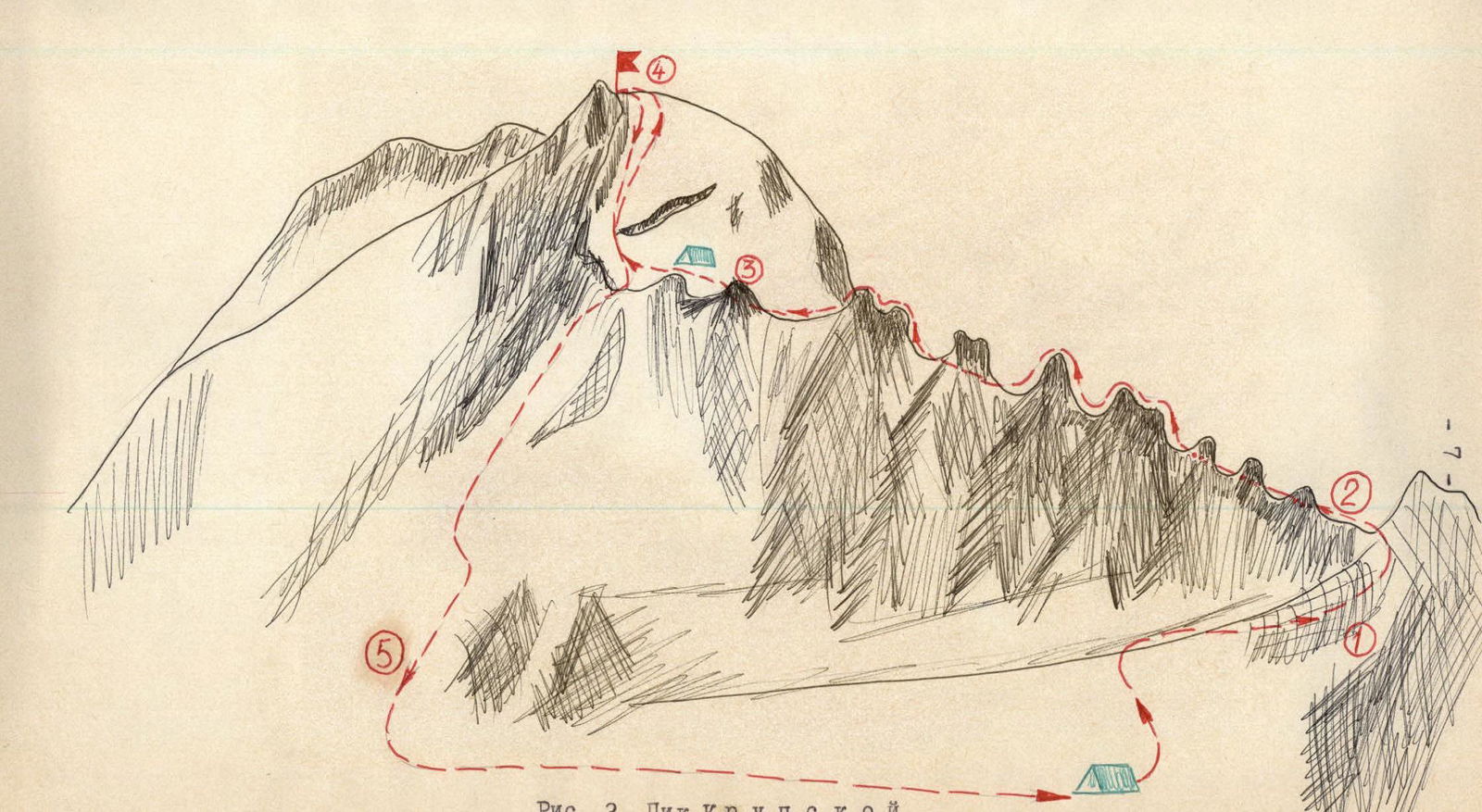
Fig. 3. Peak Krupskaya from Peak Suloyev
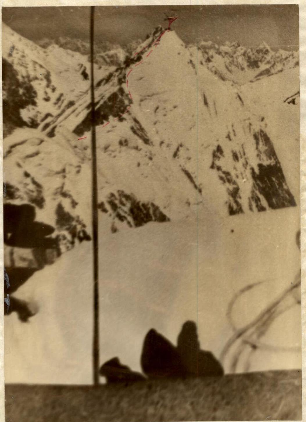
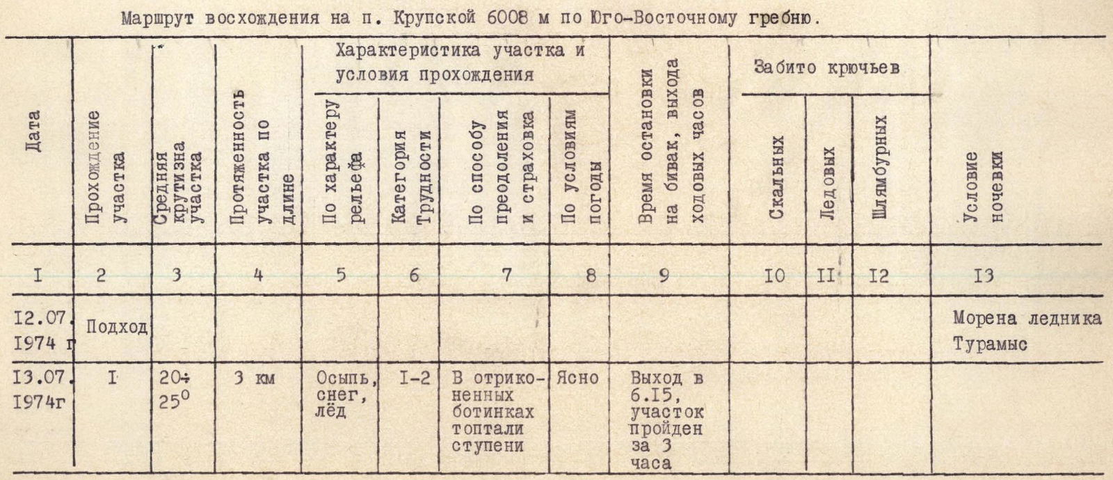
Table of Main Characteristics of the Ascent Route
Ascent route to Peak Krupskaya 6008 m via the Southeast Ridge.

| Date | Section Traversed | Average Slope of Section | Length of Section | Terrain Characteristics | Difficulty Category | Method of Ascent and Protection | Weather Conditions | Time of Departure and Duration | Pitons Driven (Rock) | Pitons Driven (Ice) | Pitons Driven (Bolt) | Camping Conditions |
|---|---|---|---|---|---|---|---|---|---|---|---|---|
| 12.07.1974 | Approach | 3 km | Talus, snow, ice | 1–2 | Cramp ons on vibram soles | Clear | Departure at 6:15, section completed in 3 hours | Moraine of Turamys Glacier | ||||
| 13.07.1974 | 2 | 50–60° | 400–500 m | Rocks, snow on ice slope | 4 | Climbing, traverse of snow slope, protection through rock features. Movement in ropes | Light cloud cover | Reached slope at 9:30, reached ridge at 11:45 | ||||
| 3 | Traverse of ridge | 1.5–2 km | Rocks, snow, covered glacier | 5 | Alternate climbing in ropes. Protection through pitons, rock features, ice axe. Crevasses. | Significant cloud cover | Began ridge traverse at 12:20, stopped for night at 18:15 | 4 | 1 | Ridge, depression on rocks. Strong wind, snow. | ||
| 14.07.1974 | 4 | 45–50° | 300–350 m | Snow | 4 | In ropes, three pitches. Protection through ice axe. Bergschrund hazard. | Clear weather | Departure at 6:15. Reached summit at 8:45 | ||||
| 14.07.1974 | 5 | 40–45° | 1600 m vertical | Snow | 4 | In ropes, three pitches, climbing, rappelling, glissading. Protection through rock features and ice axe. | Cumulus clouds | Began descent at 9:10, reached glacier at 12:30 | Base camp |
Team Captain V.A. Shuvаlov Team Coach L.N. Puchkov