Peak Kirova (6372 m)
Group Composition:
| Surname, First Name, Patronymic | Sport Rank | Year of Birth | Party Membership | Nationality | Sport Experience and Instructor Rank |
|---|---|---|---|---|---|
| KONKOV Mikhail Petrovich | МСМК | 1937 | чл. КПСС | русск. | since 1955 ст. инструктор |
| GUSEV Viktor Sergeevich | КМС | 1940 | б/п | русск. | since 1964 мл. инструктор |
| CHERNOBELSKY Iosif Vladimirovich | КМС | 1944 | б/п | еврей | since 1961 мл. инструктор |
| CHERNOBELSKAYA Valentina Alexandrovna | КМС | 1943 | б/п | русск. | since 1963 мл. инструктор |
| Nosov Anatoly Pavlovich | КМС | 1936 | б/п | русск. | since 1956 звания нет |
The route to Peak Kirova (6372 m) via the central counterfort of the Western wall, ascended by the group of the Bashkir expedition, consists of characteristic sections that can be classified as follows:
- Black Counterfort with three steep rocky ascents. The total length of this section is over 1000 meters with an average steepness of 40°–45°, height = 3950–5200 m.
- Red counterfort, consisting of a cascade of sharp rocky ascents – walls. The length of this section is 800 meters, average steepness 60°–70°, height = 5200–5800 m.
- Vertical bastion with overhanging blocks. Length – 220 meters, steepness 90°–100°, height 5900–6100 m.
- Length – 500 m. Steepness – 30°–40°, height – 6100–6200 m.
- Sharp rocky-ice ridge leading to the summit with corniced sections. Length = 800 m. Steepness – 15°–20°, height 6200 m – 6372 m.
Route Condition, Weather Conditions, Training Ascents
Weather conditions in the summer of 1972 in the area of the Fortambek glacier were characterized by frequent snowfalls, so the Western wall of Peak Kirova was snowed in more than in previous years. During the ascent, the weather was stable. Stormy winds, blizzards, and snow cover on rocky sections significantly complicated and slowed down the group's movement. But despite the unstable weather, the group advanced upward daily.
Before ascending Peak Kirova, group members conducted a series of ascents in the Fann Mountains area, including a 6B category route on the 3rd wall of Peak Bodkhona.
All ascents took place in complex weather conditions, which undoubtedly required good physical fitness, technical training, and tactical maturity.
Ascent Description
1st day – July 25, 1972. The group left the base camp at "Suloeva" meadow (Fortambek glacier) at 5:00 on July 25, 1972. To approach the wall, it is necessary to cross the left-bank moraine of the Fortambek glacier, ascend along the avalanche debris formed by ice falls from the "Trampolinny" glacier, and press against the rocks of Peak Kirova.
The route begins at the base of the "Black Counterfort" 15 meters to the right of the rocky gully with flowing water. In general, the route of this day (about 1200 m, passed along pre-installed ropes on August 19 (R0–R17)) can be characterized as alternating between three complex rocky ascents and simple ridge sections.
Rocky ascents, each over 100 m long, are quite diverse in relief (sheer short walls, overhanging rocky eaves) and have a highly destroyed rock structure. Handholds are tile-like and very fragile.
At the beginning of the route, after 200 m following a rocky ascent, the I control tur is laid (R5). Not reaching 100 m to the rocks of the red belt, the group stopped for a bivouac, laying out a convenient area for a high-altitude tent on wide stone slabs. On this day, the group moved along the route for 11 hours. The weather was variable: fog and snow in the first half of the day, and sun by the end of the day.
A note from the II control tur was left at the bivouac site. Confident overcoming of the rocky ascents of the black counterfort is possible only for climbers with good rock climbing technique and physical fitness. Sections R6–R12, where the group had to use artificial footholds, are particularly noteworthy. Many unstable stones required participants to be constantly attentive and cautious.
2nd day – July 26, 1972. Early in the morning, the weather is bad. By 11:00, it cleared up, but strong winds. Decided to proceed. Over the second working day, the group traversed the remaining part of the "black counterfort", made a right detour around the overhanging walls of the "red counterfort" along a steep ice slope and an icy gully, and reached the ridge of the "red counterfort".
Along the ridge of the "red counterfort", which is a jumble of giant rocky steps, the group reached under the wall of the 3rd step and, after 3 hours of work, constructed a platform for a tent on a small ledge. Control tours were left upon reaching the ridge of the counterfort (R21) and on the saddle (R27).
On this day, the group covered a distance of 850 meters along the wall and spent 9.5 working hours.
The rocks of the "red counterfort" are very hard but extremely destroyed. The significant steepness, destruction of the rock, and the considerable height required participants to exert considerable physical and mental tension.
Particularly complex sections on this day include R21, R23, R24, R25, R31. For example, sections R23 and R24 are a vertical 20-meter wall transitioning into a 3-meter overhang. These sections were overcome using ladders and without backpacks.
3rd day – July 27, 1972. Strong winds and variable cloudiness in the morning. Due to peaks Leningrad and E. Abalakova, heavy clouds stretched out in long tongues. The approaching bad weather is felt. Set out at 10:00.
On this day, the group advanced up the "red counterfort" another two rocky steps. At 16:00, snow began to fall, and a blizzard started. The group worked for another hour and was forced to stop. They organized a bivouac under the wall of the 5th step, moving 40 m to the right along the path onto a shelf.
The rocky steps of this day end on the south with overhanging walls, and on the north, they are gentler but complicated by rime ice.
The key moment of the 3rd day was overcoming the 3rd step along a sixty-meter internal corner (R34). The average steepness of the internal corner is 85°. The left wall of the corner is extremely destroyed (no possibility to grasp a handhold or hammer in a hook), the right one consists of smooth tile-like slabs covered with rime ice. 10 meters above the base of the corner, there is a 5-meter overhanging section, which is passed using ladders, then after 20 m, there is a cork made of unstable stones. To exit the corner, it is necessary to overcome another 4-meter overhanging wall. This section was passed without backpacks. The first ascender spent about 3 hours to pass 60 meters.
The 4th step is passed to the right along a steep, very "rotten" wall (R35).
On the third day, due to bad weather, the group moved along the route for only 7 hours and covered 260 meters.
4th day – July 28, 1972. The blizzard stopped in the morning. Variable cloudiness, strong winds. During the night, the rocks were dusted with fluffy snow. Cold.
On the fourth day, the group continued moving along the "red counterfort" and overcame the 5th and 6th steps of the cascade. The route of the fourth day consists of destroyed rocky walls complicated by rime ice and freshly fallen snow, alternating with short snow-covered ledges. The most complex section was R38, represented by a 35-meter wall with overhanging blocks.
The wall is overcome by technically complex climbing, with the extraction of backpacks. After exiting onto the 6th step, having moved about 100 meters along a relatively gentle ridge of medium complexity, they set up camp IV. Building the site took 2 hours.
On this day, the group moved along the route for 9 hours, leaving camp III at 10:00 and ascending another 300 meters. By the end of the day, the weather worsened again.
5th day – July 29, 1972. The weather is clear, but cold and strong winds. Departure at 9:30. By-passing to the right along a steep slope, a finger on the ridge, the group ascended to the 7th and then to the 8th step of the cascade along their northern walls. The relief character is similar to that of the fourth day, but the steps' walls have more significant glaciation.
Significant difficulties were encountered when passing sections R47 and R51.
After 11 hours of work, they set up bivouac V on a snow-covered section of the counterfort. On the fifth day, the group covered 450 meters.
6th day – July 30, 1972. On this day, they decided to storm the bastion – the main problem of the route. A pair of climbers set out light at 8:00, taking all available ropes – 240 meters. They managed to reach the base of the bastion (R54) and ascend 60 meters along the wall (R55–R57) to a convenient platform on a balcony. After processing, the pair returned.
The group, having ascended the pre-installed ropes to the platform, began processing a 140-meter vertical wall (R58). Work continued throughout the daylight, and already in the dark, the last backpack was pulled, and the last participant was received. The ropes were collected the next day.
Overcoming the rocks of the bastion required participants to have great technical and physical preparation. Prolonged movement along the route and the height of 6000 meters demanded enormous physical tension. The rocks of the bastion are destroyed and have several overhanging sections and cornices. To pass it, the first ascender had to go 600 m with a double rope in galoshes and pass some overhangs with free climbing. However, the backpacks were pulled up well.
Two pulls were organized on the bastion: 40 m and 140 meters.
They stopped on a small ledge after 12.5 hours of work. At 20:30, they began building a site in the dark. On this day, the weather was favorable, but it was cold, windy, and the height was taking its toll. The group advanced upward by 292 meters.
7th day – July 31, 1972. The night was restless. A gusty wind blew so strong that it broke the angular guy line of the new high-altitude tent. In the morning, the wind did not subside; it was cold but clear. Feet were very cold.
The route of this day passes first along a steep (75°–80°) rocky gully (R59), leading through 60 m to the top of the bastion. Then along the ridge for 80 m on rocks of medium difficulty to a rocky wall (R60). Under the wall, it is necessary to turn left and follow a wide rocky-ice counterfort to reach the main ridge. The rocky-ice counterfort initially represents a wide snow-ice steep slope, 250 m long with islands of rocky outcrops (R61). Then the counterfort becomes slightly more gentle and turns into a purely ice slope (R62), which is passed in crampons with support on 4 points with insurance through hooks.
At 21:00, they stopped for a bivouac, organizing camp VII on the ridge. In 11 hours of work, the group covered 685 meters.
8th day – August 1, 1972. The weather is satisfactory. Cold. Wind. Height about 6200 m. Set out at 10:00.
The path to the summit is a long, sharp rocky-ice ridge (R64). The ridge is complicated by huge cornices towards the Traube glacier and rocky spires, which are overcome head-on. In terms of technical complexity, the ridge can be assessed as a 4B category route.
On this day, they did not manage to reach the summit. Camp VIII was set up at the base of the summit tower. A site was trampled in deep, loose snow. On the same day, they managed to process the summit tower (R65, R66).
A detailed technical description of the ridge can be found in the report of the Alekseenko group, which followed the same path to the summit. On this day, they covered no less than 800 meters along the ridge and spent 8 hours. Despite the significant height (6200 m) and enormous expenditure of energy on passing the wall, group members felt satisfactory.
9th day – August 2, 1972. The weather is clear, as always, windy and cold. The height is taking its toll. Set out relatively early at 9:00 with the intention of descending to the plateau. Along the pre-processed handrails, they ascended to the summit. This took 3 hours. Further along the ridge towards Peak Kommunizma, the group descended to the Pamir Firn Plateau by 21:00. They arrived at the sites on 6100 m, left after the international olympiad, late at night. The descent path is technically simple, but the enormous physical tension during the ascent was felt. On this day, the group worked on the descent for 14 hours.
10th day – August 3, 1972. The weather is magnificent. The wind died down; it was warm. From camp IX, the group descended through the Pamir Firn Plateau, Peak Parashyutistov, and the "Camel" spire to the base camp at "Suloeva" meadow.
A detailed technical characteristic of the route is given in the table.
Summary Data of the Route and Evaluation of the Participants' Actions
- The route to Peak Kirova (6372 m) along the southwestern wall is logical, and its passage will bring satisfaction to any qualified group of athletes.
- Brief technical characteristics of the route: a) height difference – 2472 m. b) path length – 4882 m, including very complex climbing 1350 m, which consists of passing 3 rocky ascents on the "black counterfort", 8 rocky steps of the "red counterfort", and 220 meters of the main bastion of the wall. c) overall steepness of the wall before reaching the ridge – 55°. d) length of sections with backpack extraction – 325 meters.
- The ascent to the summit took 82 working hours. The ascent pace was quite high: participants were in excellent athletic form, working mainly in independent rope teams. Throughout the entire path, 303 hooks were hammered in, including 252 rock hooks and 51 ice hooks. In 44 cases, ladders had to be used.
- The route can be considered combined; participants must have crampons for passing the upper ice sections.
- The considerable length of the path, significant height, and saturation with complex sections require participants to be comprehensively prepared and, above all, morally prepared.
- Having the experience of first ascents of the fifth and sixth category of difficulty allows us to consider that the route fully meets the requirements of 6B category routes of this class.
All group members demonstrated themselves to be physically and technically well-prepared on the route, with a strong will to achieve the goal. Each participant made their personal contribution to the passage of the high-altitude and technically complex route.
The participants' well-being on the route was good.
Group leader: M. Konkov.
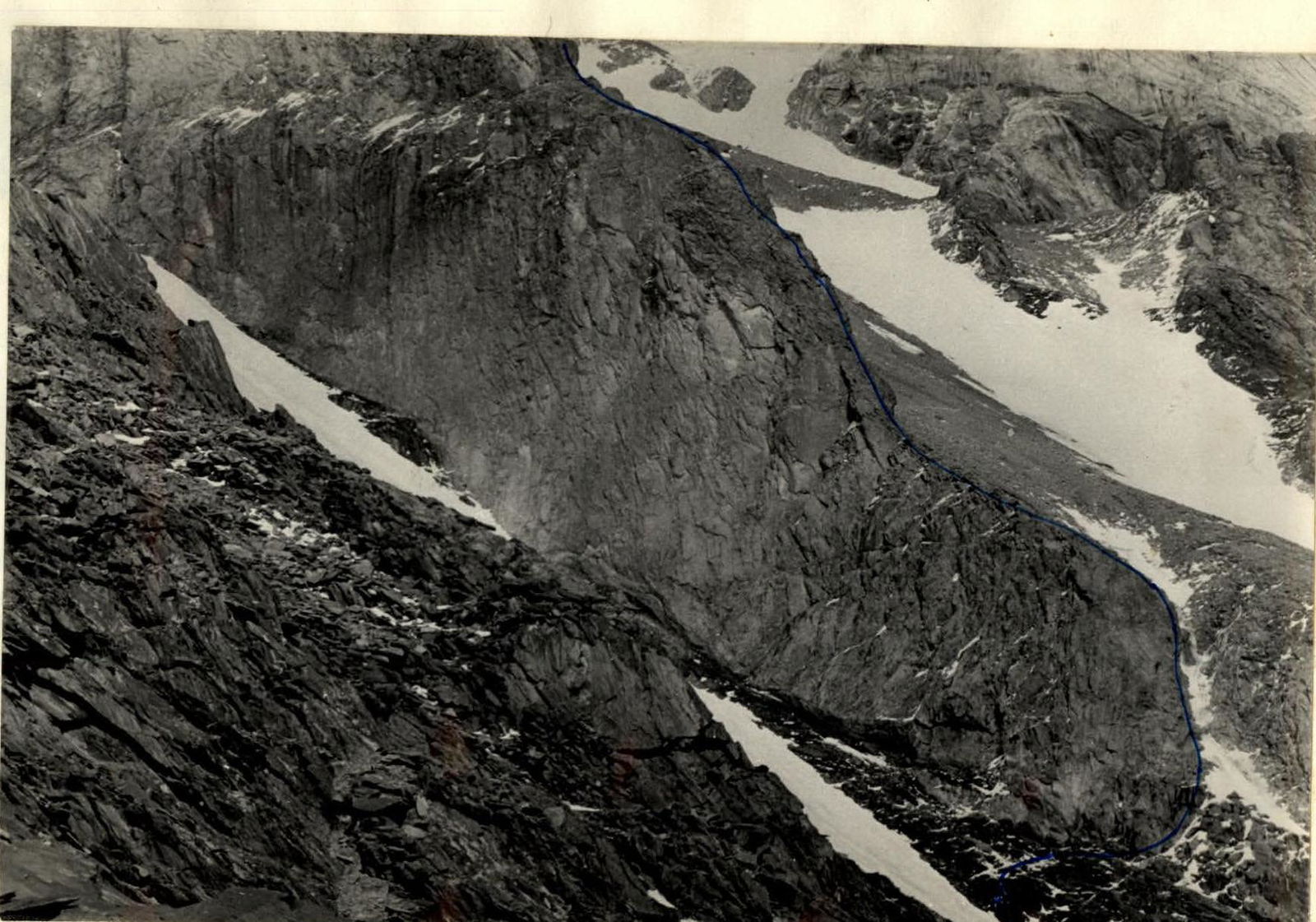
Transition path from the black counterfort to the red one and further movement path. Sections R18–R22.
Ascent route: Peak Kirova (6372 m) along the central counterfort of the Western wall
- Height difference: from 4000 m to 6372 m
- Including complex sections: 1350 meters
- Steepness of the wall before reaching the ridge: 55°
- Sections of backpack extraction: 325 m
- Path length to the summit: 4882 m
- Path length along the wall before reaching the ridge: 4000 m

TABLE OF MAIN CHARACTERISTICS OF THE ASCENT ROUTE
| Dates | № участка | Крутизна | Длина (м) | Рельеф | Техн. трудность | Способ преодоления и страховка | Погода | Время остановки | Время похода | Ходовых часов | Крючьев скальных | Крючьев ледовых | Лестниц (шт.) | Вытяжка рюкзаков (м) | Вес груза (кг) | Условия ночевки |
|---|---|---|---|---|---|---|---|---|---|---|---|---|---|---|---|---|
| 25 июля | 1 | 30° | 10 | Скалы | Скальная полка средней трудности | Страховка через выступы | Туман, временами снег | |||||||||
| 2 | 60° | 15 | Скалы | Внутренний угол | Страховка через крючья | 2 | ||||||||||
| 3 | 45° | 35 | Скалы | Скальный гребень средней трудности | Страховка через выступы | 3 | ||||||||||
| 4 | 60° | 20 | Скалы | Разрушенная скальная стенка | Через крючья | |||||||||||
| 5 | 90° | 5 | Скалы | Скальная стена с крутыми, ломкими, черепицеобразными зацепами | 2 | |||||||||||
| R6 | 30° | 400 | Скалы | Простые гребневые скалы | В связках одновременное движение, страховка через выступы | |||||||||||
| R7 | 60° | 25 | Скалы | Разрушенная стена из крупных блоков | Страховка через крючья. Применение лестниц | 3 | 3 | |||||||||
| R8 | 100° | 3 | Скалы | Нависающий карниз с вылетом около 1 м | 3 | 1 | ||||||||||
| R9 | 60° | 50 | Скалы | Скальная разрушенная стена | 6 | |||||||||||
| R10 | 100° | 3 | Скалы | Нависающий карниз с вылетом 1 м | 2 | 1 | ||||||||||
| R11 | 60° | 35 | Скалы | Разрушенная камнеопасная стена | 3 | |||||||||||
| R12 | 90° | 5 | Скалы | 3 | 1 | |||||||||||
| R13 | 15° | 40 | Скалы | Осыпная перемычка между 2-м и 3-м взлётами | Одновременное движение | |||||||||||
| R14 | 60° | 40 | Скалы | Скальный камнеопасный кулуар | Страховка через крючья | 3 | ||||||||||
| R15 | 90° | 5 | Скалы | Разрушенная стена | Страховка через крючья. Применение лестниц | 3 | 1 | |||||||||
| R16 | 40° | 60 | Скалы | Крутой разрушенный гребень средней трудности. Камнеопасно! | Страховка через выступы и крючья | 1 | ||||||||||
| R17 | 40° | 560 | Скалы | Разрушенный скальный гребень средней трудности. | Движение в основном одновременное. Страховка через выступы. На площадке II контр. тур. | Удов. 16:00 | 11 ч | 400 г | хорошие | |||||||
| 26 июля | R18 | 40° | 60 | Лед | Ледовый кулуар, спускавшийся из-под «рыжей» стены | Проходится траверсом вправо с тщательной крючьевой страховкой | 3 | 2 | ||||||||
| R19 | 75° | 55 | Скалы, лед | Скально-ледовый жёлоб в «рыжем» отроге «рыжего» пояса | Страховка крючьевая через скальные и ледовые крючья | 6 | 1 | |||||||||
| R20 | 30° | 100 | Осыпь | Осыпная широкая полка. Полка пробивается ледовыми обвалами с ледника «Трамплинного» | Движение одновременное в связках | |||||||||||
| R21 | 85° | 50 | Скалы | Вертикальный скальный жёлоб, выводящий на гребень «рыжего» контрфорса III-й кат. сл. тур. | Страховка крючьевая | 6 | ||||||||||
| R22 | 60° | 40 | Скалы | Скальный разрушенный гребень | Страховка через крючья и выступы | 3 | ||||||||||
| R23 | 90° | 20 | Скалы | Скальная стена | Участки R22–R24 | 5 | 1 | |||||||||
| R24 | 100° | 3 | Скалы | Нависающая стена, выводящая на удобную площадку – вершину I-й скальной ступени каскада | Первоидущий проходит без рюкзака, который затем вытягивается | 4 | 3 | 25 | ||||||||
| R25 | 85° | 40 | Скалы | Горизонтальный траверс по стене | Участок проходится с тщательной крючьевой страховкой | 6 | 1 | |||||||||
| R26 | 60° | 20 | Скалы | Продолжение траверса | Через крючья и выступы | 2 | ||||||||||
| R27 | 45° | 20 | Скалы | Скальный склон средней трудности, выводящий на седловину, на которой оставлен IV контр. тур | ||||||||||||
| R28 | 45° | 30 | Скалы | Скальный склон, выводящий на гребень скалы средней трудности. Камнеопасно! | Страховка через крючья и выступы | Мокрый снег | 1 | |||||||||
| R29 | 30° | 100 | Скалы | Обход нависающей 2-й скальной ступени каскада | Страховка через выступы и крючья | 2 | ||||||||||
| R30 | 70° | 70 | Скалы | Крутые гладкие плиты вдоль ледового кулуара | Страховка через крючья | 7 | 1 | |||||||||
| R31 | 90° | 10 | Скалы | Вертикальный жёлоб, залитый натёчным льдом. Жёлоб выводит на небольшую осыпную полку | Страховка крючьевая | 3 | 1 | |||||||||
| Бивуак II | 20:30 | 9:30 | ||||||||||||||
| 27 июля | R32 | 75° | 60 | Скалы | Разрушена 2 скальная стена, выводящая на гребень под 3-ю ступень каскада | Страховка крючьевая | Ясно, очень сильный ветер | 4 | хорошие | |||||||
| R33 | 50° | 20 | Лед, снег | Траверс снежно-ледового склона к основанию вертикального внутреннего угла | Страховка крючьевая. Рубка ступеней во льду | 1 | 2 | |||||||||
| R34 | 85° | 60 | Скалы, лед | Вертикальный внутренний угол с тремя нависающими участками. Одна грань угла – чрезвычайно разрушенная стена, другая – гладкие плиты, покрытые тонким натёчным льдом | Страховка крючьевая, на лестницах. Необходимо очистить зацепки и трещины от льда | 16 | 3 | 8 | 70 | |||||||
| R35 | 70° | 80 | Скалы, лед | Разрушенная стенка справа в обход 4-й ступени каскада. Стена выводит на гребень контрфорса. Верхняя часть стены (20 м) состоит из выветренных сланцевых пород | Страховка через крючья | Ухудшение погоды, снег | 6 | |||||||||
| R36 | 30° | 60 | Скалы, снег | Гребень. Скалы средней трудности, гребень упирается в стену 5-й ступени каскада | Движение одновременное, страховка через выступы | |||||||||||
| Бивуак III | В 40 метрах вправо от основания 5-й ступени каскада на осыпной полке построена площадка | Ветер и солнце. С 12:00 – снегопад, пурга | 17:00 | 7 ч | 400 г | |||||||||||
| 28 июля | R37 | 70° | 60 | Скалы, снег | Разрушенная скальная стена, присыпанная снегом | Страховка крючьевая | Пурга, снег, ветер, холодно | 5 | 1 | 400 г | ||||||
| R38 | 100° | 35 | Скалы | Стена с нависающими блоками | Использование искусственных точек опоры. Вытягивание рюкзаков | 8 | 2 | 6 | 30 | |||||||
| R39 | 45° | 40 | Снег, лед | Широкий снежно-ледовый жёлоб | Прохождение жёлоба сопровождается рубкой и выбиванием ступеней | |||||||||||
| R40 | 75° | 60 | Скалы, лед | Разрушенная скальная стена, осложнённая льдом, стена выводит на гребень выше 6-й ступени каскада | Страховка крючьевая | 6 | 1 | |||||||||
| R41 | 15° | 100 | Скалы | Гребень. Скалы средней сложности | Страховка через выступы. Движение одновременное | |||||||||||
| Бивуак IV | Справа по ходу 50 м ниже гребня выложена площадка для палатки | Пурга, снег, ветер, холодно | 19:00 | 9 ч | 400 г | хорошие | ||||||||||
| 29 июля | R42 | 40° | 80 | Снег, лед | Снежно-ледовый склон, выводящий на перемычку на гребне | Траверсом вдоль скал. Страховка через ледоруб | Сильный ветер, переменная облачность | |||||||||
| R43 | 50° | 80 | Снег, лед | Снежно-ледовый склон в обход пальца на гребне | ||||||||||||
| R44 | 55° | 60 | Снег, лед | Снежно-ледовый кулуар с островами, скалами | Страховка через крючья и ледоруб | 2 | 1 | |||||||||
| R45 | 20 | Скалы | Скальная полка влево в обход 7-й ступени каскада | |||||||||||||
| R46 | 60° | 30 | Скалы, лед | Скально-ледовая стена | Страховка через крючья. Необходимость очищать скалы от натёчного льда | 3 | ||||||||||
| R47 | 85° | 20 | Скалы, лед | Вертикальные плиты, залитые натёчным льдом | Страховка через крючья, необходимо очищать скалы от льда. Использовать ИТО | 8 | 2 | 3 | ||||||||
| R48 | 45° | 20 | Снег, скалы | Скальный жёлоб, покрытый тонким слоем снега. Жёлоб выводит на гребень выше 7-й ступени | Страховка через крючья | 1 | 1 | |||||||||
| R49 | 20° | 60 | Скалы | Гребень скалы средней сложности | Движение одновременное. Страховка через выступы | |||||||||||
| R50 | 50° | 30 | Снег | Крутой снежный склон, снег глубокий и рыхлый. Лавиноопасно! | Движение вдоль скал. Страховка через скальные крючья | 4 | ||||||||||
| R51 | 85° | 20 | Скалы, лед | Скальный жёлоб, залитый натёчным льдом и присыпанный тонким слоем снега. Камнеопасно! | Страховка через лепестковые крючья | 8 | 1 | |||||||||
| R52 | 60° | 20 | Скалы, снег | Верхняя более широкая часть жёлоба (R50–R51). Камнеопасно! | Страховка через лепестковые крючья | 3 | ||||||||||
| R53 | 40° | 25 | Снег | Широкий снежный склон, снег глубокий и очень рыхлый. Лавиноопасно! | Страховка через ледоруб | |||||||||||
| Бивуак V | На заснеженном скальном гребне в снегу вытоптана площадка для бивуака | Сильный ветер. Ясно | 20:30 | 11 ч | 400 г | хорошие | ||||||||||
| 30 июля | R54 | 30° | 100 | Скалы, снег | Широкий скальный заснеженный гребень | Страховка через ледоруб и выступы скал | ||||||||||
| R55 | 90° | 12 | Скалы | Вертикальный внутренний угол, выводящий на |