USSR Climbing Federation
USSR Climbing Championship, 1970
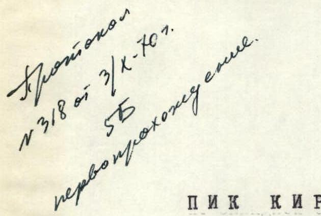
Kirova Peak via the west face (6371 m) Protocol No. 318 dated October 3, 1970. Category 5B, first ascent.
DONETSK REGIONAL COUNCIL OF "AVANGARD" SPORTS ORGANIZATION
 Donetsk, 1970
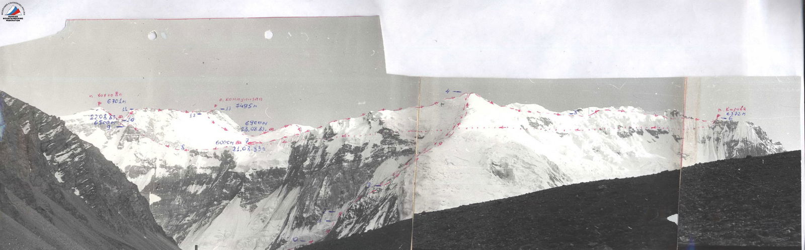
Geographical Location and Climbing Characteristics of Kirova Peak
Kirova Peak, with an elevation of 6370 m, is located in the group of peaks on the Pamir Firn Plateau, approximately 8 km northwest of the junction of the Akademii Nauk and Petra Pervogo ridges - Kommunizma Peak.
The peak's northern and western slopes are steep, particularly the western face, which drops off with 2500-meter ice-rock and rock walls, acting as bastions on the path to the plateau. The eastern ridge, gradually descending towards the Akademii Nauk ridge, and the less distinct western ridge, separated from the peak's massif by two large steps of the Trampolinny hanging glacier, form the northern edges of the plateau.
The entire massif is elongated in a northwest direction. In the same direction, a ridge extends towards NKVD Peak, gradually descending towards the confluence of the Fortambek and Valtera-Moskvina glaciers. The northern slopes of the peak and the plateau feed the Valter Glacier with snow, while the western wall is bounded by the Trampolinny and Fortambek glaciers.
The western wall is a system of steep ridges ending at the crest with sheer, sometimes overhanging bastions. The two left ridges are the most interesting in terms of climbing, composed of limestone-shale rocks and, for about a kilometer in height, marble and marble limestone.
Climbing Conditions in the Area
The region's meteorological conditions are unfavorable. Persistent cloud cover and precipitation occur in the second half of the day. Westerly and southwesterly winds prevail. The most stable weather is in August.
The area around Kirova Peak (upper reaches of the Fortambek and Turamys glaciers) was first explored by a Pamir expedition led by geologist Moskvin in 1932. That year and the following year, 1933, precise geodetic surveys of the glaciers and the eastern part of the ridge were conducted.
Climbing exploration of the area began in 1957 with an expedition by the "Burevestnik" Central Council. After a long hiatus, in 1967, climbers returned to the upper Fortambek. The "Burevestnik" expedition successfully ascended to the plateau from the Turamys Glacier, solving the long-standing problem of ascending Kommunizma Peak from the northwest.
Since then, a picturesque meadow in the pocket of the Turamys Glacier's lateral moraine has become a regular summer campsite. From here, climbers have ascended:
- Kommunizma Peak,
- Korzhenevskaya Peak,
- several peaks along the ridge separating the Turamys and Kuray-Shapak glaciers.
However, Kirova Peak remained unconquered, despite an unsuccessful attempt by I. Bogatsev's group to штурмовать the peak from the plateau.
Thus, the team's ascent was the first to Kirova Peak.
Route Description
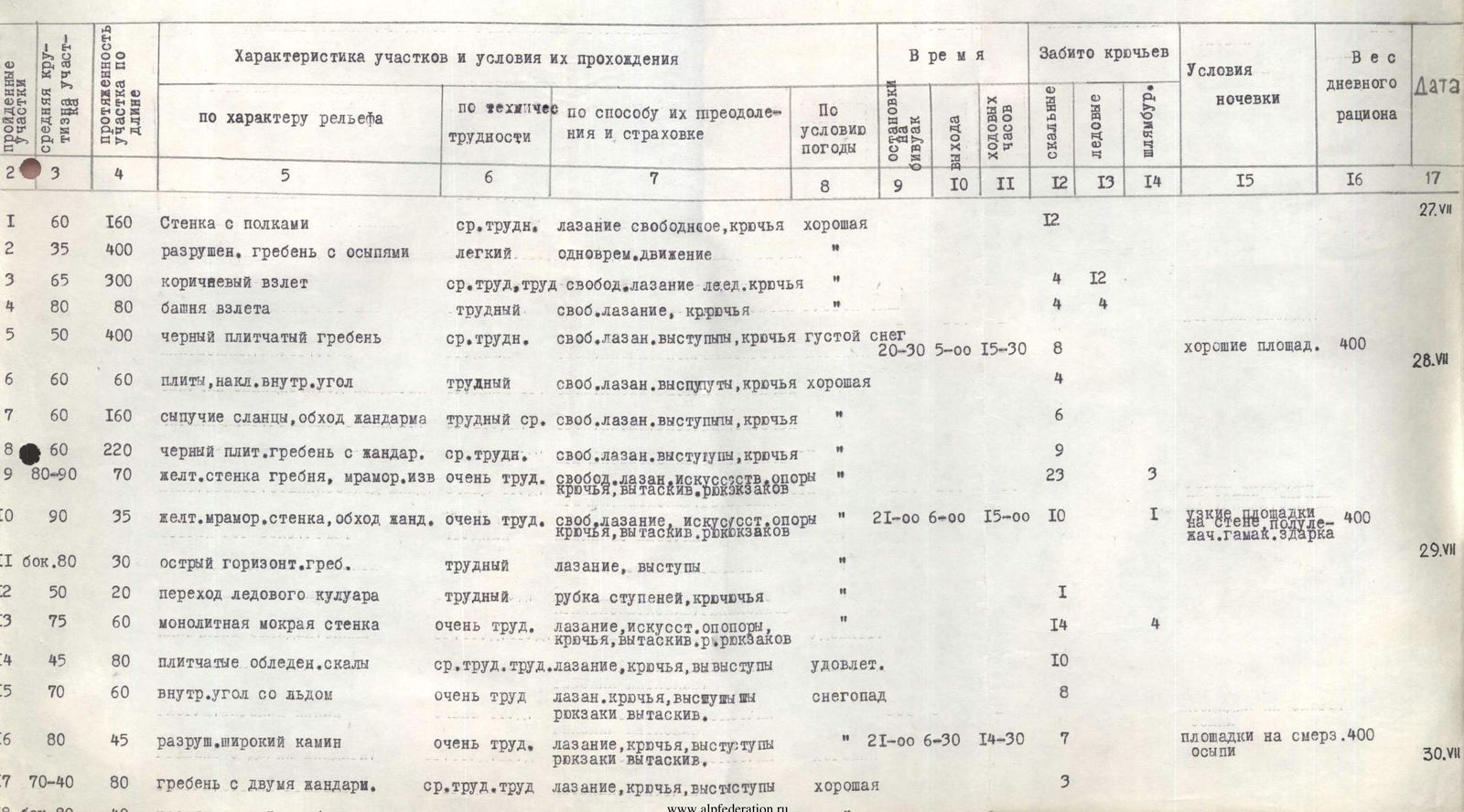
July 27, 1970
We start at 3:00 AM. Before dawn, we cross the Fortambek Glacier at its sharp turn westward and begin ascending the right orographic side of the Trampolinny Glacier's debris-covered tongue towards the second ridge of Kirova Peak.
We navigate through the lateral crevasses via unstable bridges and reach the ridge's rocky outcrops by 5:00 AM. The ridge begins with a non-steep wall featuring ledges.
- Four rope lengths of moderate difficulty climbing on crumbly rocks with protection via outcrops bring us to the bottom of a couloir separating the first and second ridges (section R0–R1).
The couloir is difficult and hazardous due to rockfall from the marble left ridge. Reconnaissance revealed that the narrow couloir floor is affected by wet snow and rock slides with the first sun rays. Despite the lower wall not being illuminated until 9:00 AM, we abandon the couloir route and instead traverse via destroyed rocks to a more challenging but safer ridge.
We ascend about 400 meters along the degraded ridge (section R1–R2) to a steep brown ascent. This ascent consists of cemented conglomerates that crumble under hands and feet, stretching about 300 meters (section R2–R3). Movement and belaying are complicated. As we ascend, the rock becomes more solid.
A steep, almost vertical tower is climbed on its left side, where it meets black shale slabs, using careful piton belays (section R3–R4).
These two sections required 7 hours during reconnaissance and processing. Now, they are traversed nearly twice as fast.
From the tower, a direct, nearly half-kilometer black slabby ridge with an angle not steeper than 60° leads to the sheer walls of a large yellow gendarme. Numerous small gendarmes on the ridge are overcome either directly or by bypassing them on the right via a steeper but climbable slope. We set up camp on pre-scouted bivouac sites at dusk.
July 28, 1970
From the bivouac, we traverse along a horizontal scree ledge and then a difficult inclined ledge (section R5–R6) leftward, bypassing the gendarme to a non-obvious couloir. Four rope lengths of steep and brittle rocks lead leftward to a sharp slabby ridge of black shales (section R6–R7). This ridge (section R7–R8) is similar to the one traversed the previous day, but shorter. It abuts against the wall of the yellow gendarme. 80 meters of extremely difficult climbing on a nearly vertical marble wall with small flaking holds lead to a steep, non-obvious ridge right of the sharp yellow gendarme (section R8–R9). The gendarme is bypassed on the left via an equally steep wall.
Only extensive training on Crimean rocks and high rock climbing skills enabled the team to successfully navigate these three rope lengths of extremely challenging rock. Extracting backpacks was particularly complicated, requiring the use of ladders.
We establish a semi-reclined bivouac under the gendarme's wall on a narrow, almost horizontal ridge, already in the dark.
July 29, 1970
The ascent begins early again, despite working 15-16 hour days with insufficient sleep. The Guru Fairylaw. An ascent team member.
The morning is very cold. We need to cross a steep ice couloir left of the ridge, which has been subject to rockfall and icefall throughout the day and night.
- We navigate a complex, narrow but horizontal ridge (section R10–R11) for 30 meters to a sheer wall and then 40 meters via rappel to the throat of the couloir with formed ice.
- 20 minutes of intense work with an ice axe on fragile ice, and the couloir is traversed. We quickly transition via ladders under the uncertain protection (section R11–R12) of the couloir's left edge, as rocks ricochet off the right edge.
We hasten upwards, fearing rockfall; however, the seemingly non-steep wet wall with a stream turns out to be at least 75° steep and icy. Ladders are used again. In the ice-filled rocks, it's hard to find cracks, so we resort to pitons. The upper 30 meters of the wall are dry monolithic rocks with small but firm holds, traversed without artificial aids. The wall ends with a terrace of overhanging blocky rocks. Upwards and rightward, 80 meters of non-steep but ice-filled, tiled rocks (section R13–R14) lead to a narrow internal corner with ice. The 60-meter internal corner (section R14–R15), transitioning into a chimney (section R15–R16), requires full exertion. The bivouac is semi-reclined, slightly below the ridge leading to the bastion, on a frozen scree slope covered with snow.
At 21:30, we signal our position with a flare, allowing the "Spartak" group to proceed to the plateau.
July 30, 1970
The day starts at 9:30 AM, but the sun is still hidden behind the bastions of the peak. It's cold.
The first gendarme on the ridge is bypassed on the right via rocks of moderate difficulty to a saddle between the first and second gendarmes.
Climbing is quite challenging (section R16–R17):
- The steep ascent with ledges on the second gendarme is tackled head-on.
- 20 meters of straightforward ridge lead to the third, not very high gendarme.
From the third gendarme, a nearly horizontal, sharp, degraded ridge extends (section R17–R18).
The gendarme is bypassed on the right via complex rocks for 10 meters. The sharp ridge's outcrops are unstable and ready to collapse, making movement very difficult and time-consuming, but there's no alternative. On the right is a rock wall, and on the left, an icy rock wall.
The sharp ridge meets a marble wall with ice on a steep ascent (section R18–R19), which is traversed without backpacks. This section of the ridge was steeper and more challenging than anticipated.
The upper 20 meters of the wall:
- Only the lead climber traverses without a backpack.
The overhanging rocks of the ascent are bypassed on the left via a steep 60° ice slope with small rock outcrops (section R19–R20). The ice is covered with a 10-15 cm layer of dry snow, hindering step cutting. We reach the ridge at a sharp gendarme-finger, which is bypassed on the right via a sheer but not too complex wall with firm holds (section R20–R21). Beyond the finger lies a section of a broad snow ridge, blown by the wind, without a cornice. We establish a bivouac here.
July 31, 1970
From the bivouac site, a 10-meter descent onto a snow saddle follows. The sheer ascent of the ridge is tackled on the left via very difficult, icy, and snow-covered rocks. The ridge then becomes less steep, around 50°, but remains challenging, with sharp rock outcrops alternating with snow-covered ice. Another small dip and a steep, icy ascent follow (section R21–R22). On the right, the ridge's sheer walls converge with the bastion's wall. We approach the base of the bastion via a steep ice slope on the left side of the ridge (section R22–R23). The wall of the bastion slightly overhangs along its entire front.
We establish a sitting bivouac on a narrow ledge carved into the ice under the wall.
August 1, 1970
The bivouac's discomfort prompts an early start. Although very cold (the sun illuminates the wall only between 13:40 and 14:00), two pairs begin processing the route at 9:00 AM without backpacks. The pair that took the left variant returns, as it's impassable.
The right variant involves a 100-meter sheer internal corner with three overhanging steps. Somewhere in the upper third of the corner, a steep, snow-covered groove leads out to the right overhanging edge, but it's impossible to reach that point via the corner, and exiting the corner is also not feasible.
50 meters of extremely challenging and hazardous climbing on the corner lead under the first overhanging step to a crack (section R23–R24). A 16-meter traverse rightward and downward with small pendulums to a short, 30° inclined ledge under a cornice, directly below the groove, follows (section R24–R25). The overhanging 35-meter wall with two cornices is traversed entirely on ladders (section R25–R26).
Pitons poorly hold in the friable rocks. Several
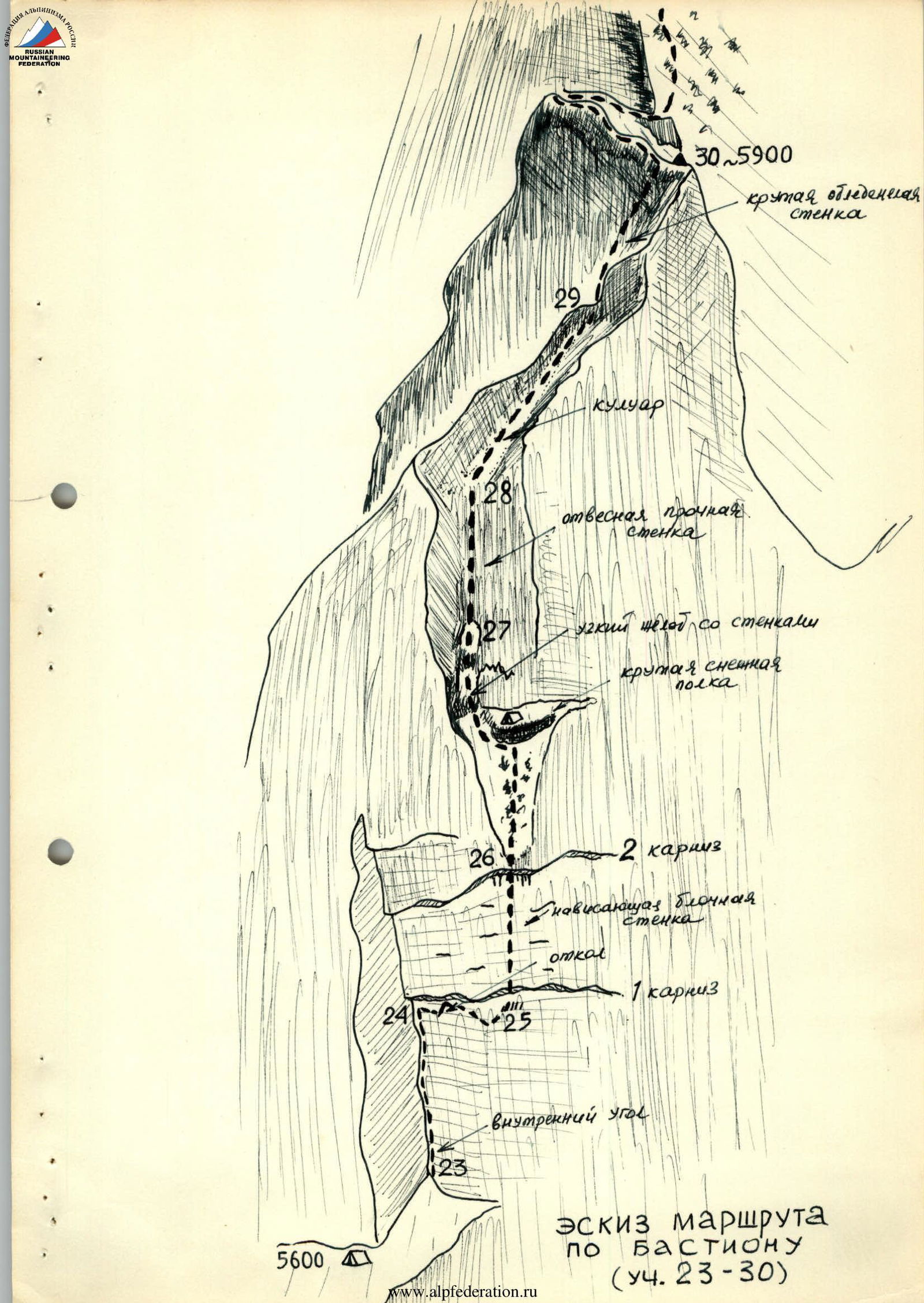
Route Sketch across the Bastion (section R23–R30)
Table
of the main characteristics of the ascent route to Kirova Peak via the west wall. Height difference - about 2500 m, including the most challenging sections - 900 m. Route steepness - 60°.
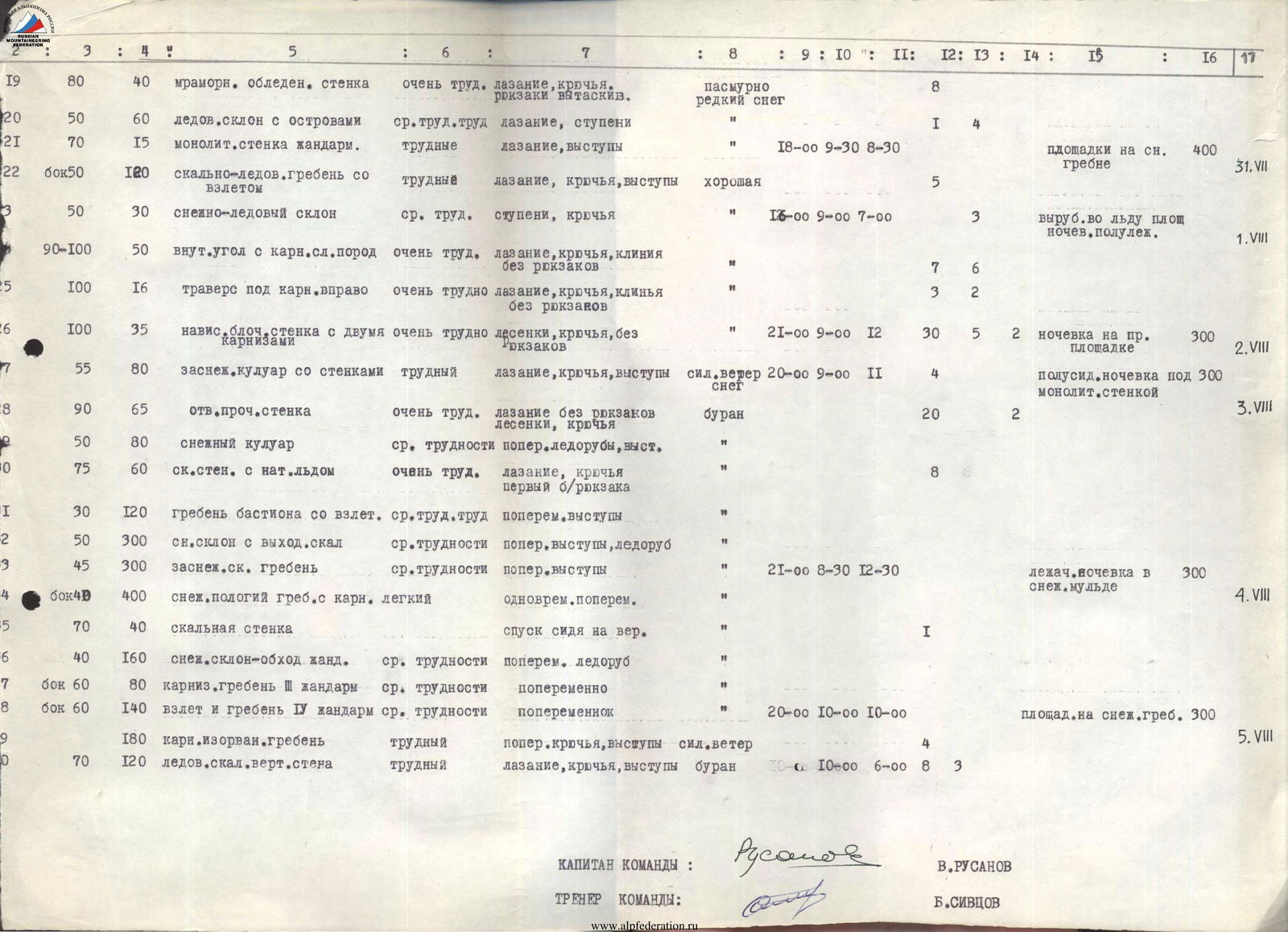
Description of the main characteristics of the route by sections: Section R19: 80 m length, 40 m height difference, marble icy wall, very difficult climbing with pitons, backpack extraction. Weather: overcast, light snow. Pitons hammered: 8. Section R20: 50 m length, 60 m height difference, ice slope with rock outcrops, medium and difficult climbing complexity, steps. Pitons hammered: 1, 4. Section R21: 70 m length, 15 m height difference, monolithic gendarme wall, difficult climbing, outcrops. Exit to a snow ridge plateau. 400 m. Section R22: (category 50) 120 m length, rocky-ice ridge with ascent, difficult climbing, pitons, outcrops. Weather: good. Pitons hammered: 5. Section R23: 50 m length, 30 m height difference, snow-ice slope, medium difficulty, steps, pitons. Time: 16:00–9:00–7:00. Pitons hammered: 3. Bivouac carved into ice, semi-reclined. Section R24: 90–100 m length, 50 m height difference, internal corner with cornices, complex rocks, very difficult climbing with pitons, wedges, without backpacks. Pitons hammered: 7, 6. Section R25: 100 m length, 16 m height difference, traverse under cornice rightward, very difficult climbing with pitons, wedges, without backpacks. Pitons hammered: 3, 2. Section R26: 100 m length, 35 m height difference, overhanging blocky wall with two cornices, very difficult ladders, pitons, without backpacks. Time: 21:00–9:00. Pitons hammered: 12, 30, 5, 2. Bivouac on the right site. 300 m. Section R27: 55 m length, 80 m height difference, snow-filled couloir with walls, difficult climbing, pitons, outcrops. Weather: strong wind, snow. Time: 20:00–9:00. Pitons hammered: 11, 4. Semi-sitting bivouac under a monolithic wall. 300 m. Section R28: 90 m length, 65 m height difference, sheer solid wall, very difficult climbing without backpacks, ladders, pitons. Weather: blizzard. Pitons hammered: 20, 2. Section R29: 50 m length, 80 m height difference, snow couloir, medium difficulty, alternating ice axe, outcrops. Section R30: 75 m length, 60 m height difference, rocky wall with formed ice, very difficult climbing, pitons, first without backpack. Pitons hammered: 8. Section R31: 30 m length, 120 m height difference, bastion ridge with ascent, medium and difficult complexity, alternating outcrops. Section R32: 50 m length, 300 m height difference, snow slope with rock outcrops, medium difficulty, alternating outcrops, ice axe. Section R33: 45 m length, 300 m height difference, snow-covered slope, ridge, medium difficulty, alternating outcrops. Time: 21:00–8:30–12:30. Reclined bivouac in a snow depression. 300 m. Section R34: 400 m length, gentle snow ridge with cornices, easy, simultaneous alternating movement. Section R35: 70 m length, 40 m height difference, rocky wall, rappel descent. Pitons hammered: 1. Section R36: 40 m length, 160 m height difference, snow slope - gendarme bypass, medium difficulty, alternating ice axe. Section R37: 60 m length, 80 m height difference, corniced ridge of RII gendarme, medium difficulty, alternating. Section R38: 60 m length, 140 m height difference, ascent and ridge of RIV gendarme, medium difficulty, alternating. Time: 20:00–10:00–10:00. Bivouac site on a snow ridge. 300 m. Section R39: 180 m length, corniced, torn ridge, difficult, alternating, pitons, outcrops. Weather: strong wind. Pitons hammered: 4. Section R40: 70 m length, 120 m height difference, ice-rock vertical wall, difficult climbing, pitons, outcrops. Weather: blizzard. Time: 10:00–6:00. Pitons hammered: 8, 3.
Pitons often pull out under load. The entire arsenal of our "forge" was used, from thin petal and piton hammers to ice screws and six-centimeter-thick wedges. Upon exiting the second cornice, almost in the groove, the rope is secured, and the pair descends to the tents via two rappels, bypassing the internal corner, as the sun sets. The tensioned rope on both rappels is thrown several meters away from the wall.
August 2, 1970
Ascending via jumars on fixed ropes and the very difficult extraction of backpacks takes almost the entire working day. The weather worsens, with a strong wind picking up and snow starting to fall by midday.
We ascend a steep, snow-covered groove under a sheer, low wall. Leftward under the wall, we enter a steep ice and snow-filled couloir. The couloir features two challenging but not high belts - walls - leading to the base of a monolithic, sheer wall (section R26–R27).
Under the howling wind, we manage to set up a bivouac, as uncomfortable as the previous ones.
August 3, 1970
The wind intensifies. It's hard to leave the tent, but staying is not an option - supplies are running low.
After traversing the loose, overhanging rocks of the lower bastion belt, a sixty-meter monolithic wall with cracks is climbed fairly confidently, sometimes via climbing and sometimes on ladders (section R27–R28). Hands freeze severely, requiring warming under the down jacket.
The wall leads to the base of a non-steep, uncomplicated snow-filled couloir, which abuts a ridge left of the main bastion ridge (section R28–R29).
A few very difficult meters along the ridge and then up its difficult, rocky left side lead to the bastion ridge (section R29–R30).
The bastion is traversed!
Three rope lengths of straightforward and non-steep ridge with ascents in a blizzard raging on the ridge more intensely than on the wall become a serious test (section R30–R31).
From the ridge, a slight descent onto a snow saddle follows, and then along a snow belt alongside the rocks of the last ridge ascent rightward, onto a snow slope with rocks - bypassing the final ascent - to the northwestern ridge of the peak (section R31–R32).
It's time to set up camp, but the wind on the ridge shoulder is so strong that setting up tents is challenging. Another hour or so of ascent along the snow-covered rocks on the right side of the ridge (section R32–R33), and we establish a bivouac in a depression between a rocky wall and a snow drift - less comfortable but reclined.
August 4, 1970
The blizzard continues to rage, especially on the ridge. Faces are encased in ice and frost. Breathing is labored, and eyes are affected. It's very cold. Visibility is about 50 meters, but the proximity of the summit is felt.
We ascend along the right slope of the gently rising corniced ridge to an ascent, and then onto the summit of RI gendarme (section R33–R34). A short descent to a snow saddle follows, and then a 30-meter rappel onto a ledge on the right side of the gendarme (section R34–R35), overcoming the gendarme.
However, traversing the deep, drifted snow on the left side of the ridge to bypass R2 gendarme to the ascent of R3 is laborious (section R35–R36). Along the edge of rocks and snow cornices, we reach the summit of the gendarme and continue along the corniced ridge to the ascent of R4 gendarme (section R36–R37), which was mistaken for the summit in the blizzard. We ascend the fairly steep and difficult but broad ridge to the summit of R4 gendarme (section R37–R38). The ridge continues to rise, and it's unclear if the sharp black peak occasionally glimpsed through the snow veil is the summit.
In a depression on the ridge, sheltered by a high rocky outcrop, we establish a bivouac.
August 5, 1970
The tenth day of our journey. The blizzard subsides somewhat in the morning, improving visibility. The black peak appears to be the summit, but the route is uncertain.
The ridge leading to it is serrated and complicated by bizarre cornices, and the ascent wall will likely require ladders. There's no easy bypass, either on the right or left; the route is only along the ridge. Nearly five hours of work with careful belaying, and the ridge is traversed (section R38–R39). The summit ascent turned out to be simpler than expected:
- 40 meters of steep ice ridge, transitioning into an ice wall,
- 70 meters of steep but dissected rocks,
- a 10-meter wide chimney
lead to the degraded, snow-covered summit dome. At 16:00, the blizzard intensifies. We leave a record of our victory by tying a can with a note to a piton on the rocks at the exit from the chimney and descend to the saddle between the summit and the gendarme or eastern summit. From there, 8 or 10 meters of rappels down a steep couloir lead to broad snow fields of moderate steepness, and leftward down the fields to the plateau. We establish a bivouac in complete darkness.
August 6, 1970
We cross the plateau widthwise towards the western ridge of Kuibyshev Peak, emerging into the fog onto the "caravan path" and meeting first an Estonian team ascending Kommunizma Peak, and then our Spartak group returning from a supply drop. Together, we cross the plateau, descend along the "Burevestnik" ridge to the "camel" and bivouac here.
August 7, 1970
We descend along the ridge onto the glacier and return to the base camp by 15:00.