Ascent Passport
- Ascent class: high-altitude technical
- Ascent area: Pamir, Peter I ridge
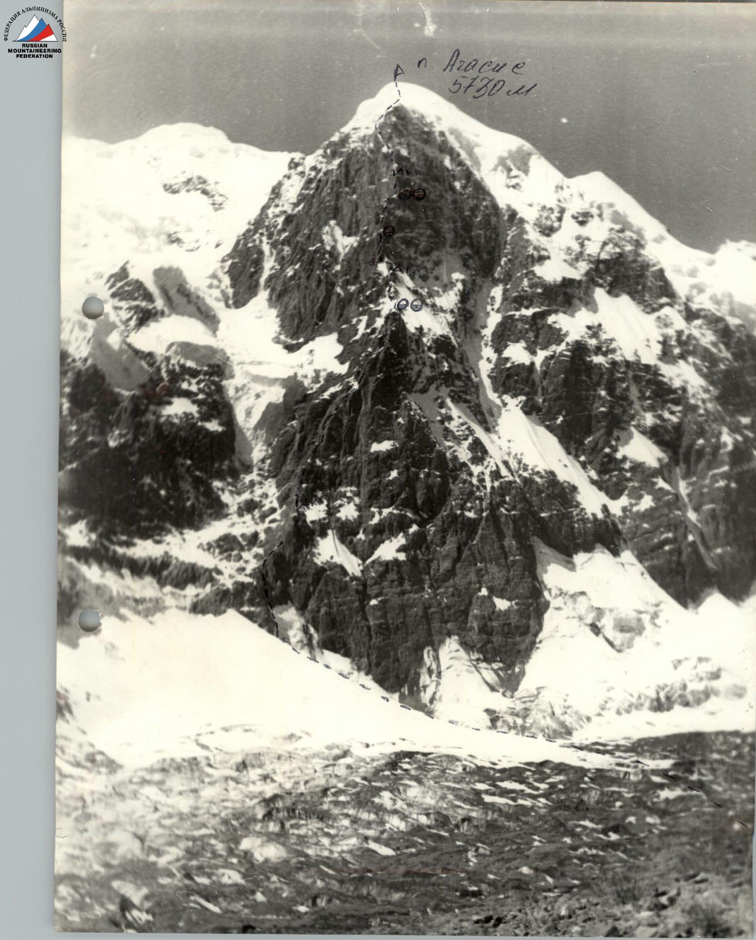
- Summit: peak Agasis, 5730 m, counterfort of the north-eastern wall
- Complexity category: 5B
- Route characteristics:
- height difference: 2200 m
- length of sections with 5–6 cat. difficulty: 1700 m
- average steepness: 75°
- Pitons driven:
- rock: 140
- ice: 24
- закладных: 110
- Climbing hours: 50 h
- Overnight stays: 5 in a tent
- Surname, name, patronymic of the leader, participants, their qualification:
- Misnik Sergey Yuryevich — CMS, leader
- Brezin Valentin Konstantinovich — CMS
- Sulimovsky Nikolai Vasilievich — CMS
- Kaloshin Sergey Alekseevich — MS
- Krivno Sergey Mikhailovich — 1st sports category
- Team coach: Klokova Agnesa Ivanovna — MS
- Date of departure on the route and return: July 15–22, 1986
- Organization: UkrSoviet "Spartak"
Brief Geographical and Sports Characteristics of the Region
The expedition team of UkrSoviet DSO "Spartak" in 1986 worked in the area of the northern spurs of Peter I ridge, between which the glaciers are located:
- Muzgasi,
- Majda,
- Barolmas.
Along the eastern and western spurs of the Muzgasi glacier stretch spurs, in which peaks are 5000–5400 m high. All of them do not have sufficiently steep and long walls, the rocks are destroyed; from an alpinist's point of view, routes through them can be laid out with 2A–5A cat. difficulty.
In the upper reaches of the Muzgasi glacier, in the Peter I ridge itself, there are three high peaks with large glaciation. One of them has a sheer wall over 1.5 km long.
This is peak Agasis, which was first ascended in 1980 by a team from CS DSO "Avangard" led by S. Bershov.
The route along the counterfort of the north-eastern wall took II place in the USSR championship in the technical class, and was rated by the team as a 6B cat. complexity route.
Near peak Agasis, in a spur that ends with peak N. Ostrovsky:
- Expeditions in 1978 and 1979 laid out two ridge routes with 4B cat. complexity.
- Our groups made two first ascents:
- to v. 5214 m (peak Karpaty) along a ridge route
- to v. 5375 m (peak Kustovskogo) along a ridge route.
The valley of the Majda glacier is descended by fairly steep walls of both lateral ridges, where complex routes can be laid out.
For the first time, the area was explored by Ukrainian alpinists in 1978 and 1979 expeditions, when the following peaks were conquered:
- Malaya Zemlya,
- peak Sirtseva,
- peak Ostrovsky,
- peak Voichenko,
- peak Vozrozhdeniya.
Our expedition's base camp was set up at a small Majda lake on alpine meadows and pastures at an altitude of 3000–3200 m, below peak Ostrovsky. There is a road leading here from Lyakhsh and Jirgatal to cattle breeders' farms. There are helicopter pads.
The path to peak Agasis:
- Goes through the grassy ridge of peak Ostrovsky,
- Further along the left-bank moraine of the Muzgasi glacier.
- The journey takes 6–7 hours to the observation camp,
- The camp is located in a green pocket of a high moraine, where a helicopter can land.

Tactics for Conducting the Ascent
The combined team of UkrSoviet DSO "Spartak" consists of experienced alpinist-rock climbers, so the basis for movement along the complex rocky terrain is free climbing with the use of a minimum number of pitons and placement of artificial holds, while not compromising safety and using placement and pitons for belaying.
The first climber is belayed with two nylon ropes. One rope remains for use as a fixed rope if the section is complex, and the second rope is used for top-rope belaying. The remaining participants move on complex sections using two ropes or with top-rope belaying.
On negative sections:
- The second rope prevents rotation.
On sections with difficulty below 5 cat. difficulty, movement is carried out in teams.
The weight of backpacks on the route does not exceed 10–12 kg, so, as a rule, movement is carried out with a backpack on all sections.
On sheer and negative sections, the backpack is attached to the harness below the belt. The first person works without a backpack.
The route is planned to be completed with 4 overnight stays on the ascent and 1–2 on the descent. Overnight stays are lying down in a tent. Food is prepared twice a day, and two stoves are taken:
- "Yuvel";
- tourist lightweight.
To pass ice slopes on the route, the following are taken:
- crampons;
- combined hammers;
- ice axes;
- titanium ice screws.
For nutrition, individual daily high-calorie rations are taken.
Communication with observers is carried out using the "Vitalka" radio station. The route is clearly visible from the observation point with binoculars.
Route Description
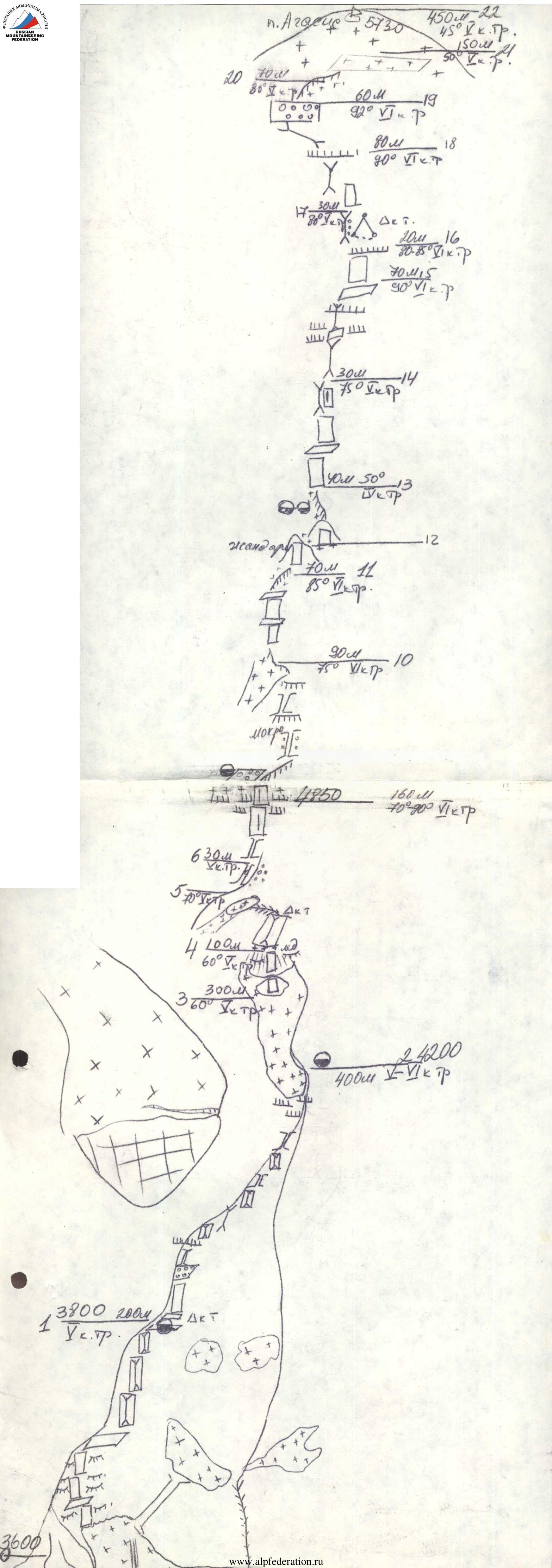
On July 15, 1986, we leave the observation camp under the wall and start the route. The terrain of the route is well studied under different lighting conditions with and without binoculars, and we know the dangerous places with regard to rockfall and ice avalanches.
- Section R0–R1. The beginning of the route is a steep ice wall 60 m.
- Further, rocks like "ram's foreheads". Ascent along a crack in the wall 60 m.
- Then along wet rocks to a series of walls, which lead through 150–200 m to a small (tent-sized) ledge. We spent the night here.
Section R1–R2. A system of depressions, ledges, and walls leads through 150 m to a steep wall with "live" stones (70 m) and further to a horseshoe-shaped scree ledge, which ends (abuts) in a wide, loose couloir with overhanging sections (80 m), then 40 m of a slightly more gentle couloir, which abuts in a cornice. Exit to a ledge. Further systems of couloirs, walls, and small cornices logically lead to a fairly large snow-ice field, clearly visible from below. A convenient place for an overnight stay.
Section R2–R3. Along a snowy ridge to the beginning of a snow-ice slope. Here should be the control cairn of the first ascenders. Due to abundant snow, we were unable to find the control cairn of the first ascenders. The snow-ice slope is overcome in crampons in the direction of a crevice dividing the first rock wall into two parts.
Section R3–R4. Further movement along the crevice. The rocks are destroyed. After the first wall, a second follows, separated from the first by a crevice filled with ice. Ascent up the wall with a slight overhang at the top. And again, a gap from the next wall, wet and icy. Descent down and a small traverse to the left with subsequent ascent straight up to a ledge.
Section R4–R5. Along a steep ledge-ridge ascent to a rocky rib.
Section R5–R6. A rocky rib, along which the ascent is straight up, then a traverse to the left, beyond a bend to the beginning of a vertical crevice.
Section R6–R7. A rocky rib, along which the ascent is straight up, then a traverse to the left, beyond a bend to the beginning of a vertical crevice.
Section R7–R8. A vertical crevice with complex climbing. Pitons and large placements are used for belaying.
Section R8–R9. Continuation of the crevice, but the rocks are more destroyed, and before exiting onto a rocky ridge with a cornice — icy. Having overcome two small cornices, we exit onto an ice cornice.
Section R9–R10. At first along a slab under the cornice to the right, then entry into a chimney (wet with ice) and straight up to a wet cornice, which is bypassed along slabs to the left. Exit onto a small ridge with snow.
Section R10–R11. Movement occurs along the N wall. At first, steep snow to rocks, then a traverse to the right and ascent upwards. The entire section is combined: rocks, ledges are filled with ice, under the top, rocks are destroyed. The end of the section is a small ridge to a vertical gendarme.
Section R11–R13. A smooth wall is passed by the first climber with assistance from below. There are crevices for small placements. After the wall, a small descent down and along a snow-ice ridge ascent to the beginning of the 3rd bastion. A little lower, we stop for the night.
Section R13–R14. At first, a destroyed wall, then a traverse along a ledge to the left to an internal corner — the most dissected section of the bastion. Movement is also possible straight up along a crevice, but on ITO.
Section R14–R16. An internal corner with a large number of vertical and horizontal crevices. Complex and pleasant climbing — rocks are firm. Under the top, before exiting onto a scree ledge, several cornices are passed by free climbing. Every day in the second half, it starts snowing and is quite cold.
Section R16–R17. A destroyed internal corner with large stones — everyone passes very carefully. The corner ends with an abyss to the left and movement upwards along smooth, overhanging rocks or a transition (complex) to the left, then straight up. We move to the left (pendulum) for 20 m.
Section R17–R18. The direction of movement is under a large cornice, which seems to cover the internal corner. At first, complex climbing along the wall, exit under a flake inside the corner and ascent under the cornice.
Section R18–R19. The cornice is bypassed to the left and along overhanging rocks, taking a few steps to the left along a vaguely expressed corner, we exit onto the bend of the upper bastion on its eastern side.
Section R19–R20. Wet rocks, complex to overcome. The end of the bastion is felt — rocks are wet from upper snow-ice slopes. We exit onto a rocky counterfort a little below the snow-ice ridge and along a snowy slope (Kalgaspory) ascend to the ridge.
Section R20–R22. A snow-ice slope is passed in teams with variable belaying and we exit onto a small plateau, from which the ascent is straight up along a snow-ice slope to the summit. The summit is the highest rocky peak, which we ascend on the same day.
Due to lack of visibility (thick fog) after radio communication with observers, senior coach, and head of rescue, we decide to descend along the ascent route. The descent took two days.
Conclusion
The route to the summit of peak Agasis along the counterfort of the NE wall turned out to be long, technically and physically complex, but very interesting. A major role is played by the correctly chosen tactics for conducting the ascent. For safe passage of the route, we recommend observing the route for several days, paying special attention to:
- the regime of avalanches from the ice "triangle" to the left of the route;
- the descent of snow avalanches from the "roof".
The first ascenders rated this route as 6B cat. complexity. We fully join this assessment, adding that a route of such length (about 2.5 km) is the first we've encountered. The route features all forms of rock relief: snow, steep ice; the most diverse methods of overcoming complex sections were used. In bad weather conditions, the passage of the route can be greatly complicated due to rapid icing of wet rocks.