497
of 30.09.80, 5B cat., semi-circular traverse.
Ascent Passport
- ASCENT CLASS: technically challenging
- ASCENT AREA, RIDGE: Pamir, Peter I Ridge
- PEAK, ITS HEIGHT, ASCENT ROUTE: Unnamed, 5730 m, North-East wall, counterfort
- PROPOSED DIFFICULTY CATEGORY: 6B cat. diff.
- ROUTE CHARACTERISTICS: Height difference: 2130 m. Length of sections with 5B–6B cat. diff.: 1765 m. Average steepness: 79°
- PITOONS DRIVEN:
- For belaying: rock — 224, ice — 65, bolt — 1 (on descent).
- For creating artificial holds: chocks — 232.
- TOTAL CLIMBING TIME: 50 hours
- NUMBER OF NIGHTS AND THEIR CHARACTERISTICS: 4 in tent
- SURNAME, NAME, PATRONYMIC OF THE LEADER, PARTICIPANTS, THEIR QUALIFICATION: BERSHOV SERGEY IGOREVICH — Master of Sports GRIGORENKO–PRIGODA YURY IVANOVICH — Master of Sports GRISHCHENKO VICTOR IVANOVICH — Master of Sports PILIPENKO VLADISLAV SERGEEVICH — Master of Sports TOLSTOUSOV ALEXANDER NIKOLAEVICH — Master of Sports
- TEAM COACH: Grigorenko–Prigoda Yu. I. — Master of Sports
- DATE OF DEPARTURE AND RETURN: July 27 – August 1

Brief geographical and sports characteristics of the area
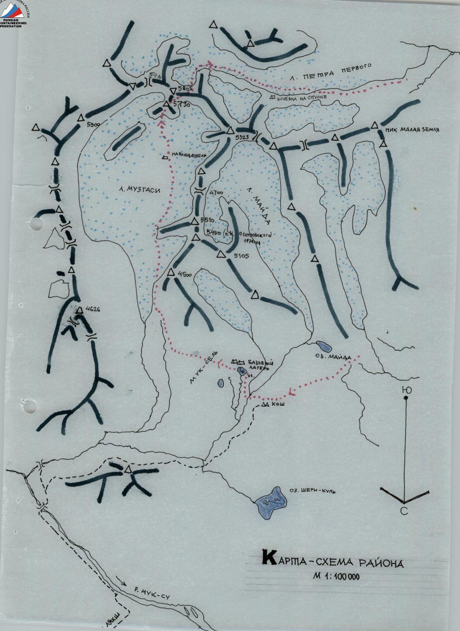
The Peter I Ridge in the NW Pamir is where the Ukrainian Trade Union Council and the Central Committee of the Lenin Communist Youth Union expedition worked in 1978 and 1979, and the Kharkov Mountain Sports Committee expedition worked in 1980.
The ridge stretches almost strictly in the latitudinal direction for 160 km; at its junction with the Academy of Sciences Ridge stands the highest peak in our country — Peak Kommunizma.
The area is interesting in terms of sports. Dozens of peaks with heights of 4500–5500 m await their conquerors via routes of any complexity, up to 6B cat. diff.
In 1875, V. F. Oshanin visited this area, researched it, described it, and named the Peter I Ridge.
In 1899, the Russian researcher V. M. Lipsky surveyed the area in the upper reaches, describing the largest glaciers.
In the 1920s, mountaineers were more interested in the Peak Kommunizma area. The first peak on the Peter I Ridge was conquered in 1947 by an expedition led by V. M. Abalakov — Peak 30th Anniversary of the Soviet State.
In 1978 and 1979, the following peaks were conquered: Malaya Zemlya (5120 m), Severcev Peak, Ostrovsky Peak (5490 m), and Tseline Peak (4620 m).
The Peter I Ridge is a watershed between the Surkhob and Obikhingou rivers. Glaciers in the lower part are heavily crevassed and covered with moraines. There are many rocks of volcanic origin. In the upper part, the glaciers are heavily snow-covered. Ridges have many cornices. The area has significant glaciation. Weather from the end of June to the beginning of September is stable. By the end of the day, clouds appear on the peaks, and snow is possible.
The nearest large settlements are the district centers Lakhsh and Jirgital, which have airports and are connected by a highway to Dushanbe. In the area where the expedition worked, at an altitude of 3000–3200 m, there is a huge grassy plateau used as pastures for sheep, horses, and cows. Many farms and koches are located on the plateau, where vehicles arrive daily to collect milk and serve the livestock. From our camp to Lakhsh, it's 24 km by vehicle.
When dismantling the base camp at 7:00, the entire team was at the airport by 11:00; the cargo was delivered by car.
Two separate roads are laid out on the plateau: from Jirgital and from Lakhsh. The roads do not connect on a 4 km section, where a good trail is laid.
The base camp was located on a small lake Moid under Ostrovsky Peak. 2 km from the camp is a farm, where a car arrives daily from Lakhsh. The ascent object, Peak 5730 m, is located in the upper reaches of the Muzgasi glacier.
From the base camp to the Muzgasi glacier, it is necessary to cross a grassy ridge from Ostrovsky Peak.
The path along the glacier runs mainly along the left-bank moraine, but it is also possible to go along the glacier.
From the base camp to the wall of Peak 5730 m, it takes 5–6 hours.
Tactics for conducting the ascent and using new equipment samples
The combined team of the CS DSO "Avan-gard" consists of experienced mountaineers and rock climbers, so the basis of movement through complex rock terrain is free climbing with minimal use of pitons and chocks for creating artificial holds, without compromising safety, and using chocks (factory-made) and pitons (mostly titanium) for belaying.
Skyhooks are used to pass smooth walls and slabs.
Bolt pitons are taken on the route in limited quantities.
The first climber is belayed with two nylon ropes. One rope remains for use as a running belay if the section is complex, and the second rope is used for top-rope belaying. Other participants move on complex sections using two ropes or with top-rope belaying.
On overhanging sections, the second rope prevents rotation. On sections with a difficulty below 5th category, movement is in teams. The weight of backpacks on the route does not exceed 10 kg, so, as a rule, movement is with a backpack on all sections.
On steep and overhanging sections, the backpack is attached to the harness below the belt. Rope hauling is rarely used by the team (hauling takes a lot of time).
Backpacks are light due to modern equipment: a backpack made of "aviazent", a down jacket, a down sleeveless jacket, a shortened sleeping bag made of lightweight fabrics, an ice axe, a combined hammer, chocks, and a gas stove.
In the team, everyone takes turns leading and constantly rotates, allowing the group to move at a high pace.
The route is planned to be completed with 4 bivouacs on the ascent and 1–2 on the descent. Overnight stays are planned to be lying down in a tent. Separate overnight stays are possible; for this, a tent and a "zdarka" are taken.
Hot food is prepared twice a day — a primus stove and a gas stove with 3 cylinders are taken (total burning time — 12 hours).
To pass icy slopes, crampons, combined hammers, ice axes, and titanium ice screws are taken on the route.
For nutrition, it is planned to take individual daily rations with high-calorie food (dry-cured sausage, nuts, raisins, honey, protein, protein cookies) and a shared kitchen (tea, oatmeal, milk mixture, soups).
Communication with observers is carried out via a "Vitalka" radio station; communication is duplicated with flares.
Description of the approach to the route
From the base camp located by the lake under the northern slopes of Peak 5490 (Ostrovsky Peak), through a small pass, we descend into the Muzgasi valley. Along the right lateral moraine of the glacier, we move until the slopes of Peak 5490 start to block the path steeply. We descend down to the Muzgasi glacier. A landmark for the descent is a large stone on the lateral moraine of the glacier. It takes 2.5–3 hours to reach this stone from the base camp.
Then we go along the center of the glacier in the direction of a fairly large stream falling with a small waterfall from the right (in the direction of travel) onto the glacier. Along the stream, we climb again onto the lateral (right) moraine of the glacier, along which we go to the north-eastern biscuit 5730. The upper part of the wall opens only after 3 hours of walking from the base camp, and the entire path to the route takes 5–6 hours.
A helicopter landing on the glacier is possible under the route. It is also possible to approach the route along the center of the Muzgasi glacier.
The upper part of the NE wall of Peak 5730 is visible in good weather from the Lakhsh airport.
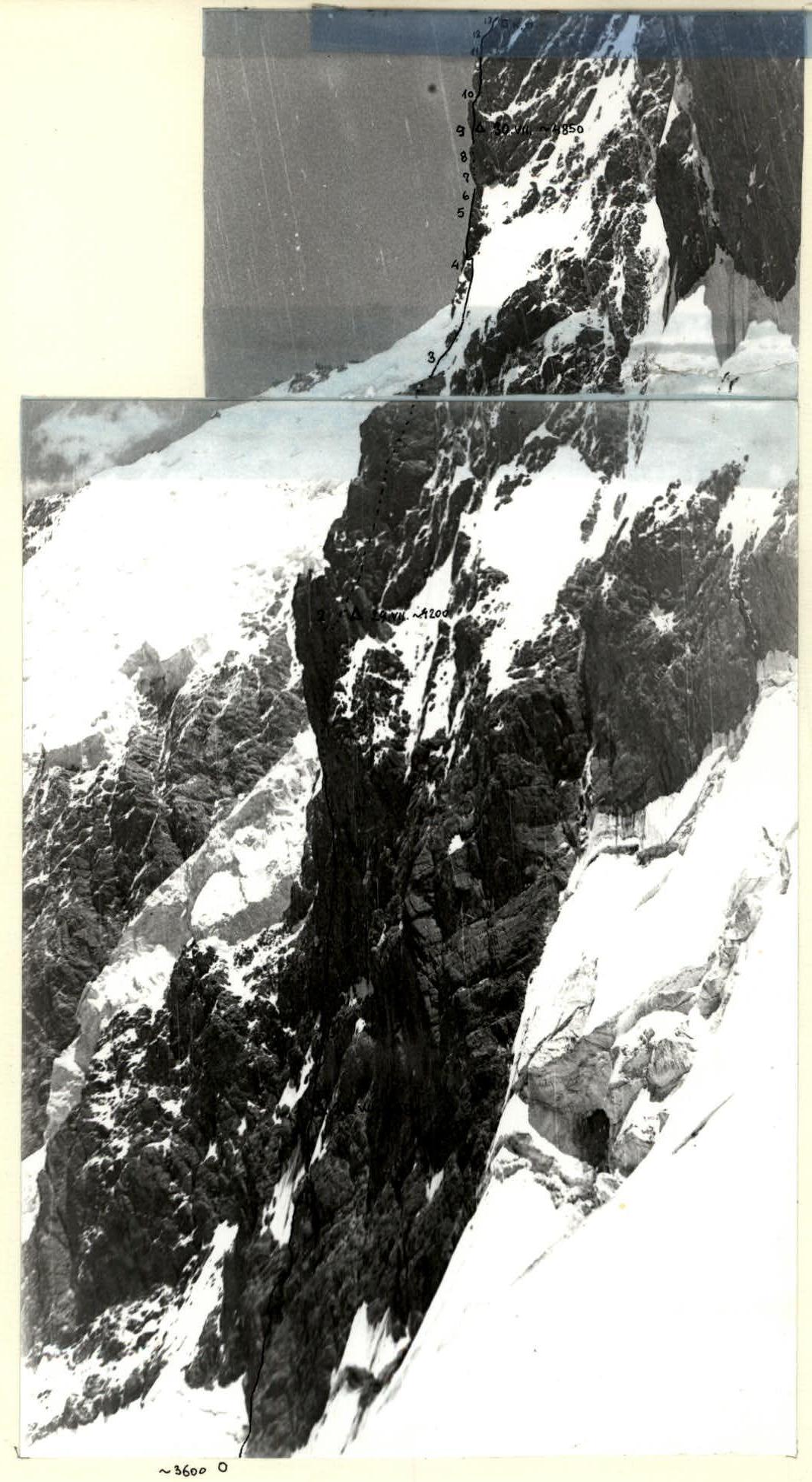
Profile snapshot of the route
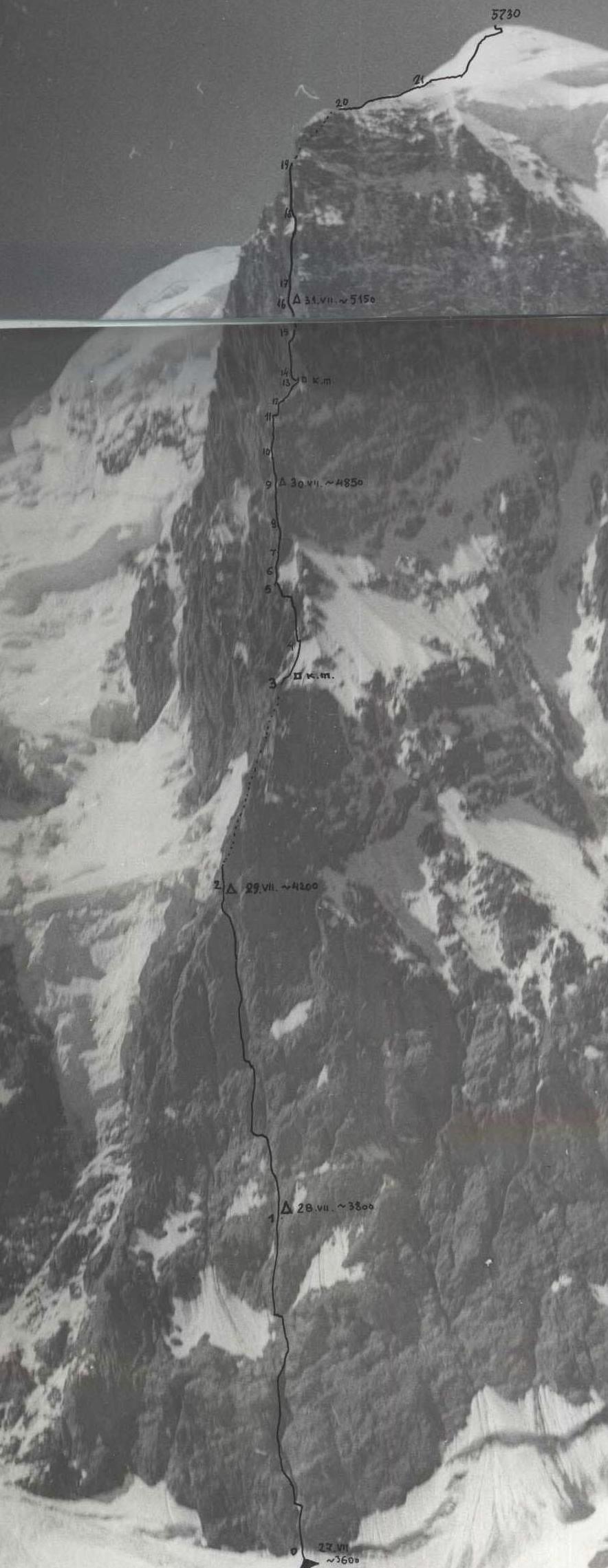
General view of the wall and route

| DATE | Section | AVG. STEEPNESS | Length, m | RELIEF CHARACTERISTICS | Cat. diff. | CONDITION | WEATHER CONDITIONS | Rock | Chocks | Ice | Bolt |
|---|---|---|---|---|---|---|---|---|---|---|---|
| July 27 | R0 | 70° | 240 | Chimney. Monolith. Rocks like "ram's foreheads" | 5 | Wet | Good | 32 | 20 | ||
| Departure | — | 80° | STOP FOR BIVOUAC | Climbing hours — 10 | |||||||
| July 28 | R1 | 80–90° | 400 | Inner corner | 6 | Crumbly, steep | Good | 51 | 49 | 3 | |
| Departure | — | 80° | STOP | Climbing hours — 10 | |||||||
| July 29 | R2 | 60° | 300 | Inner corner | 5 | Crumbly, wet | 25 | 26 | |||
| R3 | 55° | 100 | Snow-ice slope | 5 | Ice with a thin layer of snow | In the second half of the day | 10 | 7 | |||
| R4 | 75° | 80 | Walls with cracks | 5 | Wet, rime ice | 11 | 9 | 1 | |||
| R5 | 50° | 30 | Shelf | 4 | Icy | Snow | 3 | 4 | |||
| R6 | 70° | 40 | Rock rib | 4 | Monolith | 4 | 10 | ||||
| R7 | 90° | 50 | Vertical crack | 6 | Monolith | 8 | 7 | ||||
| R8 | 92° | 70 | Crack with cornices | 6 | Crumbly, icy | 8 | 12 | ||||
| Departure | — | 80° | STOP | Climbing hours — 11 | |||||||
| July 30 | R9 | 85° | 90 | Chimney with a cornice in the middle | 5 | Icy | 10 | 11 | |||
| R10 | 85° | 70 | Shift with rime ice | 6 | Rime ice | In the second half of the day | 10 | 15 | |||
| R11 | 90° | 15 | Smooth wall | 6 | Monolith | 1 | 2 | ||||
| R12 | 50° | 40 | Ice ridge | 4 | Snow | 2 | 3 | ||||
| R13 | 85° | 30 | Wall with a shelf | 5 | Monolith | 1 | 5 | ||||
| R14 | 90° | 70 | Inner corner with cracks | 6 | Monolith | 7 | 15 | ||||
| R15 | 80° | 20 | Wall | 5 | Monolith | 4 | |||||
| Departure | — | 90° | STOP | Climbing hours — 9 | |||||||
| July 31 | R16 | 80° | 30 | Inner corner | 5 | Crumbly | Good | 3 | 4 | ||
| R17 | 90° | 80 | Inner corners | 6 | Monolith | 12 | 15 | ||||
| R18 | 92° | 60 | — | 6 | — | 14 | 17 | ||||
| R19 | 80° | 70 | — | 5 | Crumbly, icy | 11 | 9 | 5 | |||
| R20 | 30° | 150 | Sharp snow-ice ridge | 4 | 10 | ||||||
| R21 | 45° | 450 | Snow-ice slope | 4 | 36 | ||||||
| Departure | — | 90° | STOP | Climbing hours — 10 | |||||||
| Total | — | — | 2475 | — | — | — | — | 224 | 234 | 65 | 1 |
Total route length: 2475 m. Wall length: 1875 m. Number of bivouacs on ascent: 4; on descent: 1; total climbing hours: 50.
Note: the length of the sections was measured with a 40 m rope.
Explanations for the table of main characteristics of the ascent route
On July 27, 1980, the last preparations before departing on the route were completed; the route relief was well studied — observed in different lighting conditions, with binoculars and without, in profile and en face; we knew the dangerous areas regarding rockfall and icefall — very often ice falls to the left of the first rock bastion, but all observations and studies were behind us — today we are departing on the route. The last overnight stay on the glacier together with observers.
We depart at 8:00. We go in the direction of a clearly defined chimney starting directly from the Muzgasi glacier — only a small randkluft separates the glacier from the rocks.
Section R0–R1. The beginning of the route is a chimney filled with ice inside. The left side of the chimney, which is only lit by the sun in the evening, has rime ice. The first 40 m are passed on the right side of the chimney, where the rocks are drier. Rocks like "ram's foreheads". The first climber goes in caloshes. The next 40 m are passed through the chimney with a transition to its left part. It's quite cold; the sun is still hidden behind the ridge, and the lower part of the wall starts to be lit after 10:00. Further movement is along the wet rocks of the left part of the chimney towards a large ice field, where there is a transition to the right and upwards under an overhanging wall, along which we reach the beginning of a huge inner corner. This corner resembles the 90-meter corner on the western wall of Peak Chapdara (Sолонников's route, 6B cat. diff.) but is several times longer, as it turned out. We find a convenient place to bivouac near a snowpatch, to the right of the beginning of the inner corner. The Bershov–Tolstousov team departs for processing — the rest are engaged in construction work — making platforms for a tent and a "zdarka". First control check.
July 28. Early rise, food preparation, and departure again at 8:00. The tactics of processing the route (1–2 ropes) justify themselves — passing along the hung ropes, we start to get accustomed to the further loads of the day.
Section R1–R2. A huge inner corner, representing a system of internal corners, with rocks firm for 1/3 of the section's length. The upper part overhangs and is very crumbly. For belaying, large horizontal pitons and medium-sized chocks work well. Several ice screws are also used for driving into rocks.
Slabs, flakes, and cracks on the left part of the inner corner are passed with free climbing.
After exiting the inner corner — a traverse under the start of a large couloir (inner corner) onto a shelf, where the second bivouac on the route is organized. The shelf is good, and the tent is set low and wide, allowing everyone to fit in the tent across it. And again, passing several ropes for the next day.
July 29. Section R2–R3. Begins with crumbly rocks, then smooth slabs, dusty and unpleasant to pass, after which there is a transition to the right part of the corner and ascent straight up to the start of a crumbly ridge. The left part of the corner has rime ice, winter-type. Exit onto the ridge and along the ridge to the start of a snow-ice slope. On the ridge — 2nd control check.
Section R3–R4. The snow-ice slope is passed in crampons towards a crack dividing the first rock wall into two parts.
Section R4–R5. Further movement is along the crack. Rocks are crumbly. After the first wall follows a second, separated from the first by a crack filled with ice. Ascent along the wall with a slight overhang in the upper part. And again, a gap from the next wall, wet and icy. Descent down and a short traverse to the left followed by an ascent straight up onto a shelf.
Section R5–R6. Along a steep shelf-ridge, ascent to a rock rib R6–R7. The rock rib is ascended straight up, then a traverse to the left, behind a bend, to the start of a vertical crack.
Section R7–R8. The vertical crack has complex climbing. Belaying is with pitons and through large chocks.
Section R8–R9. Continuation of the crack, but rocks are more crumbly, and before exiting onto a rock ridge with a cornice, they are icy. Having overcome two small cornices, we exit onto a cornice (ice), where, after significant construction work, we lay out a platform.
Section R9–R10. July 30. At first, along a slab under a cornice to the right, then entry into a chimney (wet with ice) and straight up to a wet cornice, which is bypassed along slabs to the left. Exit onto a small ridge with snow. Movement on this section is in caloshes. We have two pairs of caloshes, sizes 6 and 7, which fit everyone.
Section R10–R11. Movement passes along the N wall. At first, steep snow to the rocks, then a traverse to the right and ascent upwards. The entire section is combined — rocks, shelves covered with ice; under the top, rocks are crumbly. The end of the section is a small ridge to a vertical "gendarme".
Section R11–R12. The smooth wall is passed by Bershov with assistance from below. There are cracks for small chocks. After the wall, a slight descent down and along a snow-ice ridge, ascent to the start of the 3rd bastion.
Section R13–R14. At first, a crumbly wall, then a traverse along a shelf to the left to an inner corner — the most dissected section of the bastion. Movement is also possible straight up along a crack, but on artificial holds.
Section R14–R16. The inner corner has many vertical and horizontal cracks. Complex, pleasant climbing — rocks are firm. Under the top, before exiting onto a crumbly shelf, several cornices are passed with free climbing. On the crumbly shelf, to the right, it is possible to make a platform for a tent, but having passed a 20-meter wall, we find a shelf, on which, after construction work, we lay out a platform. All overnight stays are made "capital", as every day, in the second half, it starts to snow and is quite cold.
July 31. Section R16–R17. A crumbly inner corner with large stones — everyone passes very carefully. The corner ends with a drop to the left, and movement is either straight up along smooth, overhanging rocks or a (complex) transition to the left and then straight up. We go to the left (pendulum) for 20 m.
Section R17–R18. The direction of movement is under a large cornice, which seems to cover the inner corner. At first, complex climbing along the wall, exit under a flake inside the corner, and ascent under the cornice.
Section R18–R19. The cornice is bypassed on the left, and along overhanging rocks, grabbing a few meters to the left along a vaguely expressed corner, we exit onto the bend of the upper bastion, onto its eastern side. Rocks are of unusual structure — inclusions of stones of various sizes in a softer rock; despite this, the rocks are firm.
Section R19–R20. Wet rocks, complex to overcome. The end of the bastion is felt — rocks are wet from the upper snow slopes. We exit onto a rock counterfort slightly below the snow-ice ridge and along a snow slope (glacier slope) climb onto the ridge, hoping that the right side of the ridge is gentler. But the ridge drops steeply to the west.
Section R20–R22. The snow-ice slope is passed in teams with alternating belaying, and we exit onto a small plateau, from which we ascend straight up along a snow-ice slope to the summit. The summit is the highest rock peak, which we climb on the same day.
August 1. We bivouac just below the summit on a crumbly shelf from the south. We descend along the Western ridge to a saddle and then to the SW onto the Peter I glacier. In two days, we return (August 3, 1980) to the base camp under Ostrovsky Peak.

Section R7–R8.
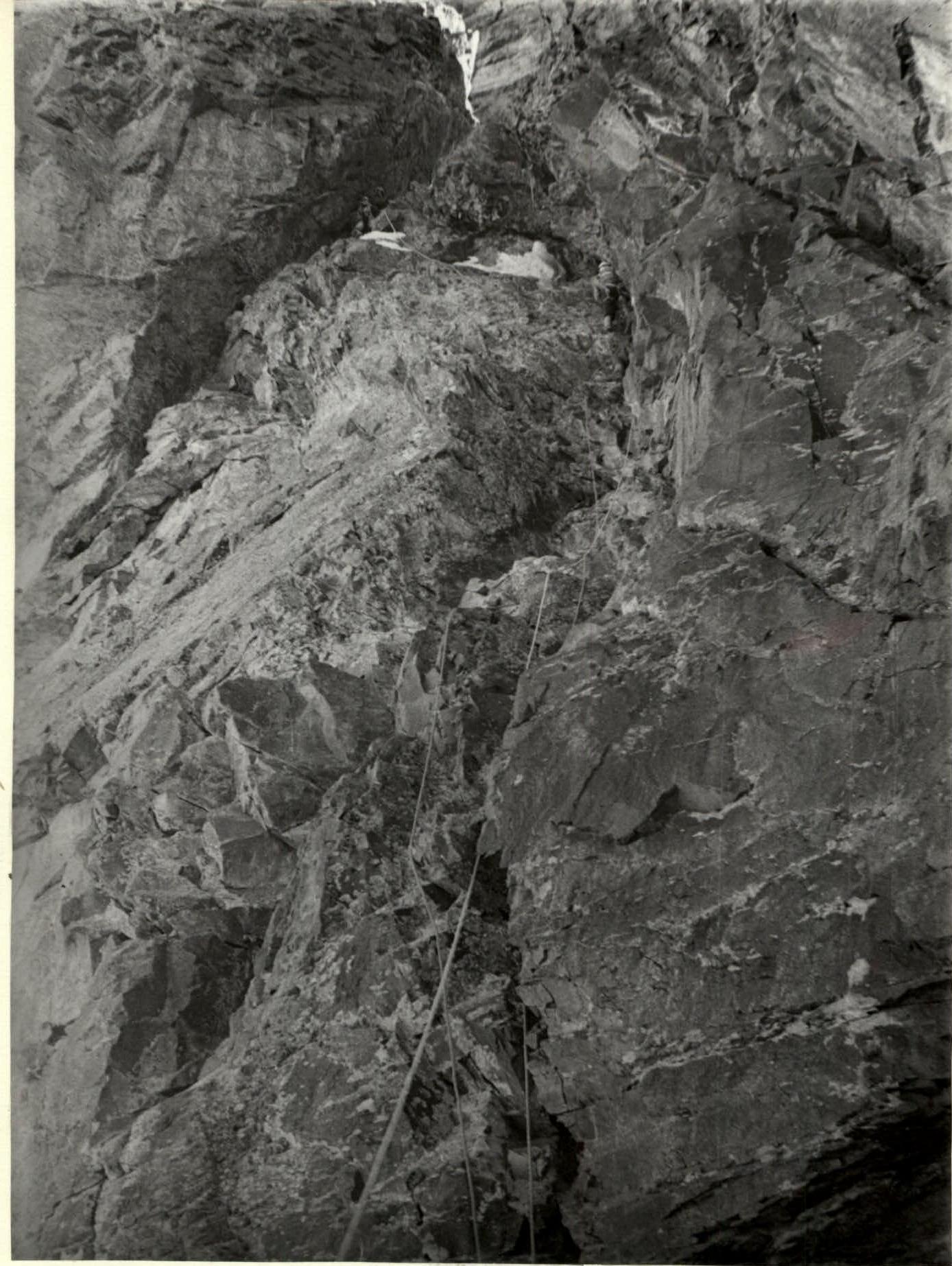
Movement on section R8–R9.