- Class of ascent
- Altitude-technical;
- Region of ascent
- North-West Pamir, Petra Pervogo Ridge;
- Peak, its height, route
- peak Evgenia Abalakova, 6446 m via the north face;
- Estimated difficulty category
- Sixth;
- Route characteristics:
- Height difference — 2300 m;
- Length of sections with 5–6 diff. cat. — 950 m;
- Average steepness — 55°;
- Pitons driven:
- for belaying:
- rock — 135;
- ice — 49;
- bolt — –;
- for AIDs:
- rock — 11;
- ice — 3;
- bolt — –;
- Number of climbing hours
- 60;
- Number of bivouacs
- 5;
- Bivouac characteristics:
- lying on ice and snow — 2;
- lying on a rock shelf — 2;
- sitting on a rock shelf — 1;
- Surname, name, patronymic of the leader, participants and their qualification:
- Kavunenko Vladimir Dmitrievich — Master of Sports of International Class, leader;
- Sviridenko Vadim Sergeevich — Master of Sports, participant;
- Bashkirov Vladimir Leonidovich — Master of Sports;
- Kondakov Evgeny Ivanovich — Master of Sports;
- Smirnov Evgeny Germanovich — Master of Sports;
- Orobej Igor Alexandrovich — Candidate Master of Sports;
- Serpak Alexander Alexandrovich — Candidate Master of Sports;
- Team coach
- Kavunenko V.D.;
- Date of departure on the route
- July 26, 1979;
- Date of return to the alpine camp
- August 1, 1979
Conventions: snow-ice relief, rocky relief
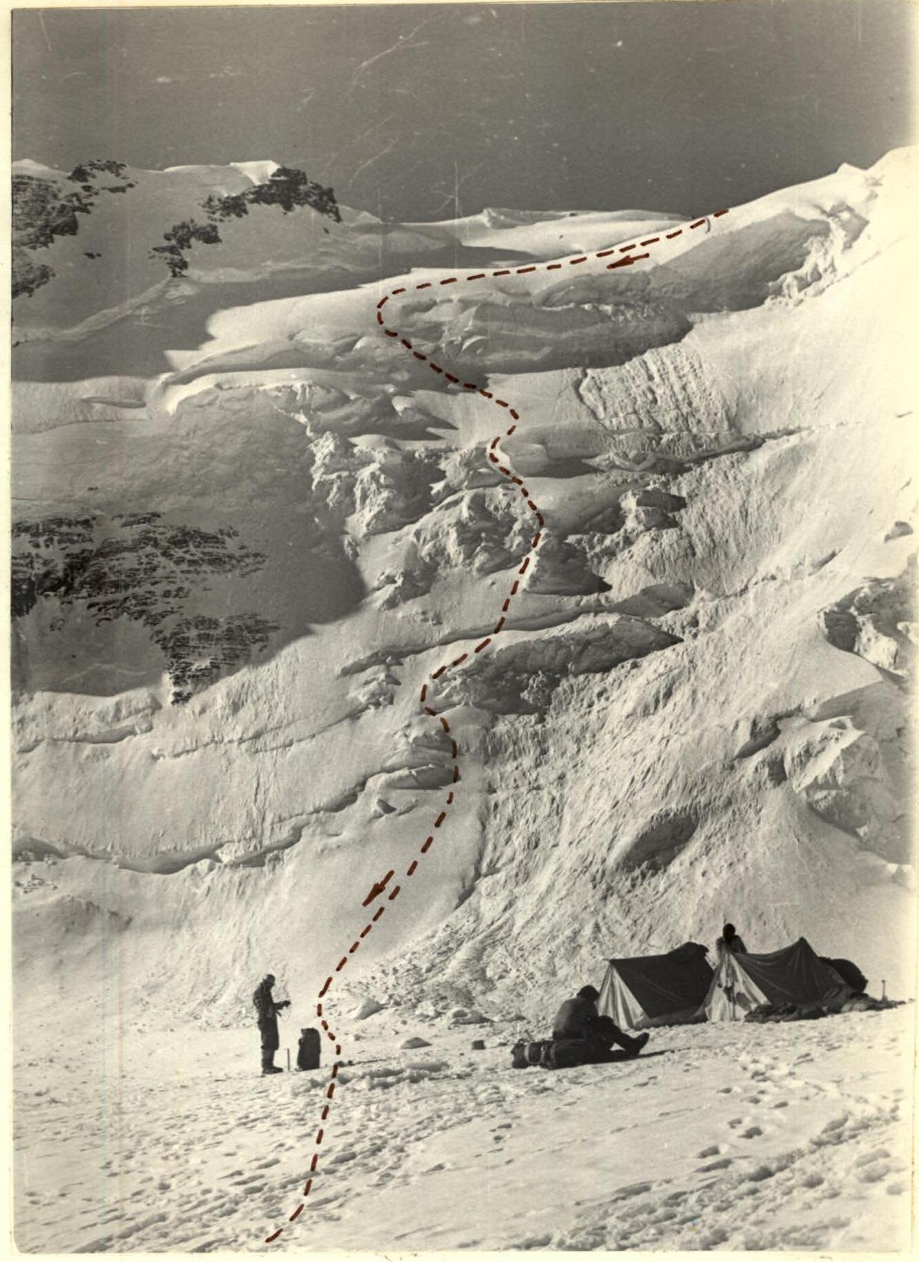
July 30, 6370 m.
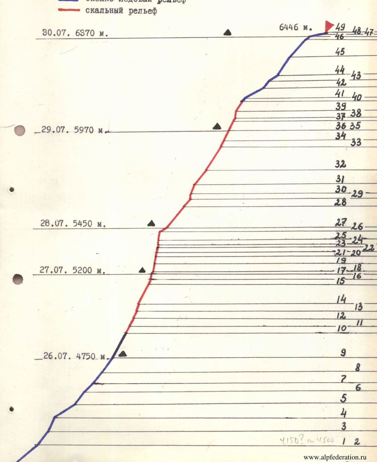 Table of main characteristics of the ascent route
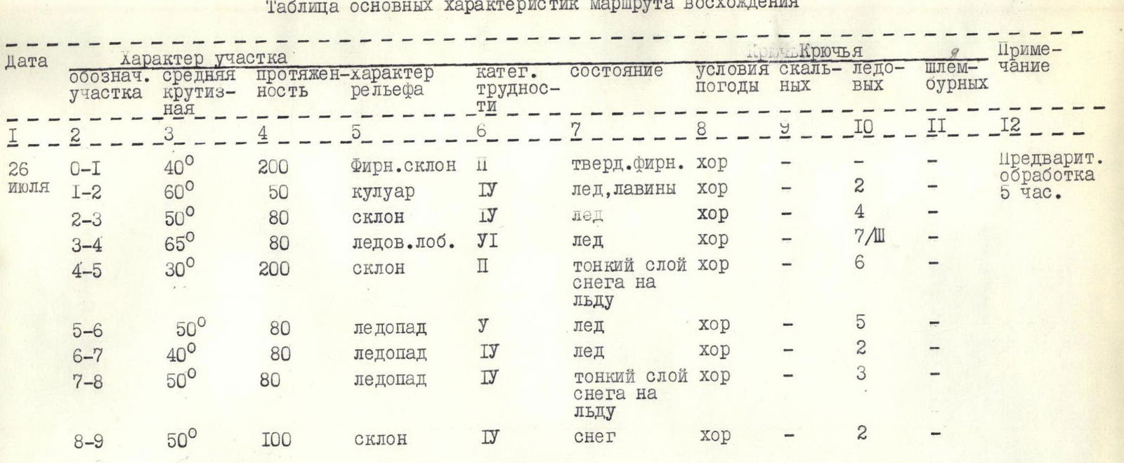
| Date | Section | Average steepness | Length | Terrain type | Diff. cat. | Condition | Weather conditions | Rock pitons | Ice pitons | Notes |
|---|---|---|---|---|---|---|---|---|---|---|
| July 26 | R0–R1 | 40° | 200 m | Firn slope | 2 | Hard firn | good | – | – | Preliminary |
| R1–R2 | 60° | 50 m | Couloir | 4 | Ice, avalanches | good | – | 2 | Processing 5 hours | |
| R2–R3 | 50° | 80 m | Slope | 4 | Ice | good | – | 4 | ||
| R3–R4 | 65° | 80 m | Ice ledge | 6 | Ice | good | 7 | 3 | ||
| R4–R5 | 30° | 200 m | Slope | 2 | Thin layer of snow on ice | good | – | 6 | ||
| R5–R6 | 50° | 80 m | Icefall | 4 | Ice | good | – | 5 | ||
| R6–R7 | 40° | 80 m | Icefall | 4 | Ice | good | – | 2 | ||
| R7–R8 | 50° | 80 m | Icefall | 4 | Thin layer of snow on ice | good | – | 3 | ||
| R8–R9 | 50° | 100 m | Slope | 4 | Snow | good | – | 2 |
Departure time — 7:00. Bivouac stop — 20:00. Climbing hours — 11. Bivouac on a platform carved in ice, lying down.
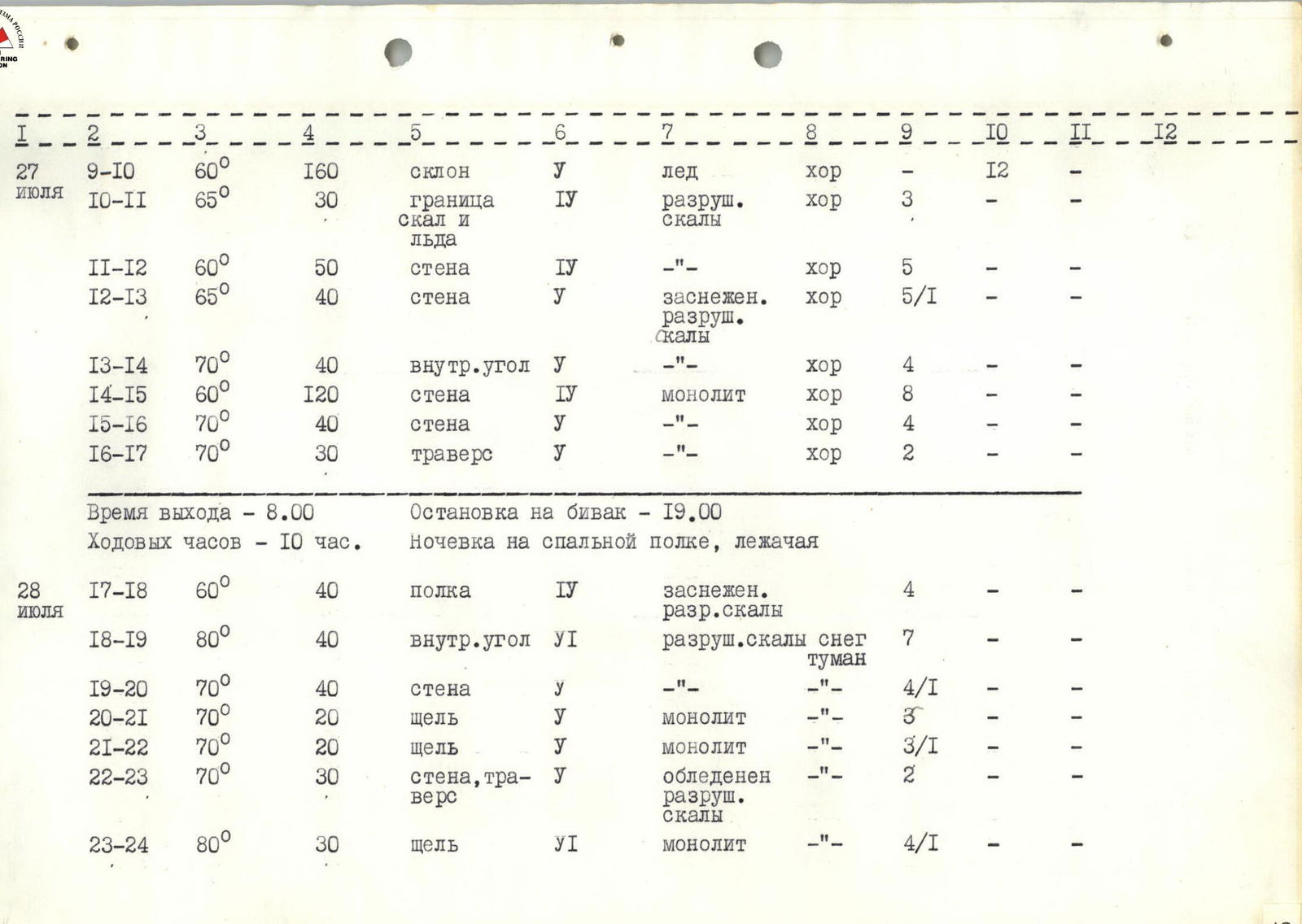
| Date | Section | Average steepness | Length | Terrain type | Diff. cat. | Condition | Weather conditions | Rock pitons | Ice pitons | Notes |
|---|---|---|---|---|---|---|---|---|---|---|
| July 27 | R9–R10 | 60° | 160 m | Slope | 4 | Ice | good | 12 | – | |
| R10–R11 | 65° | 30 m | Boundary of rocks and ice | 4 | Destroyed rocks | good | 3 | – | ||
| R11–R12 | 60° | 50 m | Wall | 4 | – | good | 5 | – | ||
| R12–R13 | 65° | 40 m | Wall | 4 | Snowy, destroyed rocks | good | 5 | 1 | ||
| R13–R14 | 70° | 40 m | Inner corner | 4 | – | good | 4 | – | ||
| R14–R15 | 60° | 120 m | Wall | 4 | Monolith | good | 8 | – | ||
| R15–R16 | 70° | 40 m | Wall | 4 | – | good | 4 | – | ||
| R16–R17 | 70° | 30 m | Traverse | 4 | – | good | 2 | – | ||
| Departure time — 8:00. Bivouac stop — 19:00. Climbing hours — 10. Bivouac on a rock shelf, lying down. | ||||||||||
| July 28 | R17–R18 | 60° | 40 m | Shelf | 4 | Snowy, destroyed rocks | – | 4 | – | |
| R18–R19 | 80° | 40 m | Inner corner | 6 | Destroyed rocks, snow, fog | – | 7 | – | ||
| R19–R20 | 70° | 40 m | Wall | 4 | – | – | 4 | 1 | ||
| R20–R21 | 70° | 20 m | Crack | 4 | Monolith | – | 3 | – | ||
| R21–R22 | 70° | 20 m | Crack | 4 | Monolith | – | 3 | 1 | ||
| R22–R23 | 70° | 30 m | Wall, traverse | 4 | Icy, destroyed rocks | – | 2 | – | ||
| R23–R24 | 80° | 30 m | Crack | 6 | Monolith | – | 4 | 1 |
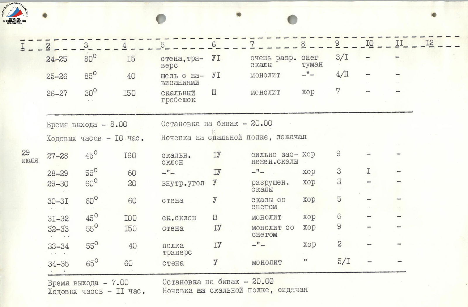
| | Date | Section | Average steepness | Length | Terrain type | Diff. cat. | Condition | Weather conditions | Rock pitons | Ice pitons | Notes | |:------------|:--------|:-----------------|:-------|:--------------------|:-----------|:--------------------|:-------------------|:------------|:-----------|:------| | July 28 | R24–R25 | 80° | 15 m | Wall, traverse | 6 | Very destroyed rocks, snow, fog | – | 3 | 1 | | | | R25–R26 | 85° | 40 m | Crack with overhangs | 6 | Monolith | – | 4 | 1 | | | | R26–R27 | 30° | 150 m | Rocky ridge | 3 | Monolith | good | 7 | – | | | | | | | | | | | | | | | | Departure time — 8:00. Bivouac stop — 20:00. Climbing hours — 10. Bivouac on a rock shelf, lying down. | | July 29 | R27–R28 | 45° | 160 m | Rocky slope | 4 | Snowy rocks | good | 9 | – | | | | R28–R29 | 55° | 60 m | – | 4 | – | good | 3 | 1 | | | | R29–R30 | 60° | 20 m | Inner corner | 4 | Destroyed rocks | good | 3 | – | | | | R30–R31 | 60° | 60 m | Wall | 4 | Rocks with snow | good | 5 | – | | | | R31–R32 | 45° | 100 m | Rocky slope | 3 | Monolith | good | 6 | – | | | | R32–R33 | 55° | 150 m | Wall | 4 | Monolith with snow | good | 9 | – | | | | R33–R34 | 55° | 40 m | Shelf, traverse | 4 | – | good | 2 | – | | | | R34–R35 | 65° | 60 m | Wall | 4 | Monolith | – | 5 | 1 | | | | | | | | | | | | | | | | Departure time — 7:00. Bivouac stop — 20:00. Climbing hours — 11. Bivouac on a rock shelf, sitting. |
| Date | Section | Average steepness | Length | Terrain type | Diff. cat. | Condition | Weather conditions | Rock pitons | Ice pitons | Notes |
|---|---|---|---|---|---|---|---|---|---|---|
| July 30 | R35–R36 | 55° | 30 m | Shelf | 4 | Snowy rocks | clear, cold | 5 | – | |
| R36–R37 | 65° | 60 m | Couloir, transition to a groove | 4 | Monolith | – | 7 | 1 | ||
| R37–R38 | 30° | 20 m | Rocky ridge | 3 | – | – | 2 | – | ||
| R38–R39 | 80° | 40 m | Wall | 6 | Snowy rocks | – | 4 | 1 | ||
| R39–R40 | 65° | 60 m | Wall | 4 | Monolith | good | 4 | – | ||
| R40–R41 | 45° | 20 m | Ice slope | 4 | Ice | good | 3 | – | ||
| R41–R42 | 30° | 200 m | Slope | 2 | Deep snow | good | – | – | ||
| R42–R43 | 45° | 60 m | Slope, traces of crevasses | 3 | Deep snow | good | – | 2 | ||
| R43–R44 | 30° | 60 m | Slope | 3 | Ice, deep snow | good | – | – | ||
| R44–R45 | 50° | 120 m | Slope | 4 | Loose deep snow | fog, cold | – | – | ||
| R45–R46 | 45° | 120 m | Slope | 3 | – | – | – | – | ||
| Departure time — 7:00. Bivouac stop — 21:00. Climbing hours — 11. Bivouac in a snow depression, lying down. | ||||||||||
| July 31 | R46–R47 | 40° | 40 m | Slope | 3 | – | good | – | – | |
| R47–R48 | 10° | 80 m | Snow ridge | 1 | – | good | – | – | ||
| R48–R49 | 40° | 20 m | Rocky ridge | 3 | Rocks with snow | good | – | – | ||
| Departure time — 8:00. Reaching the summit — 10:00. Climbing hours — 2. Total climbing hours — 60. |
Brief explanation of the table of main characteristics of the route
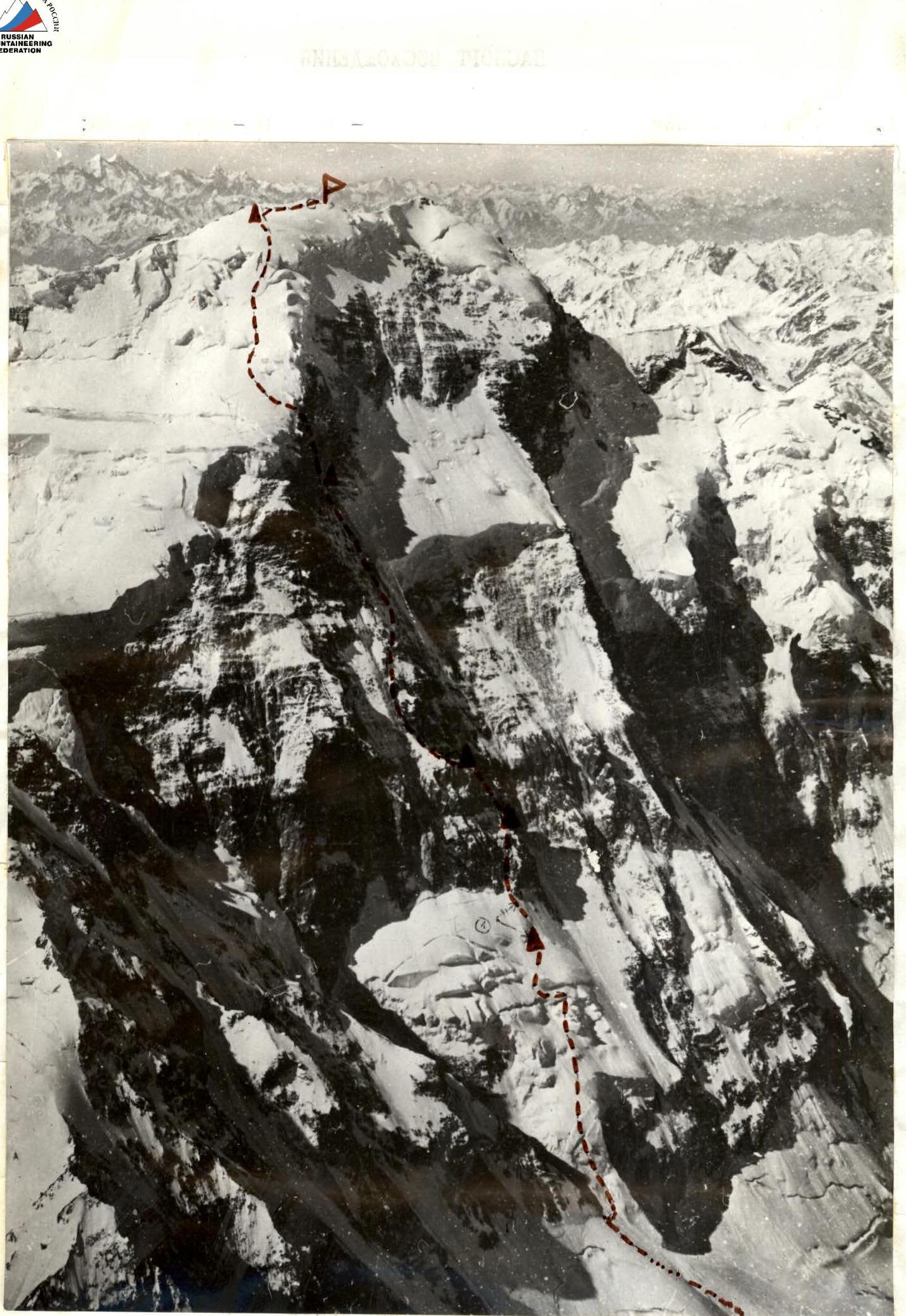
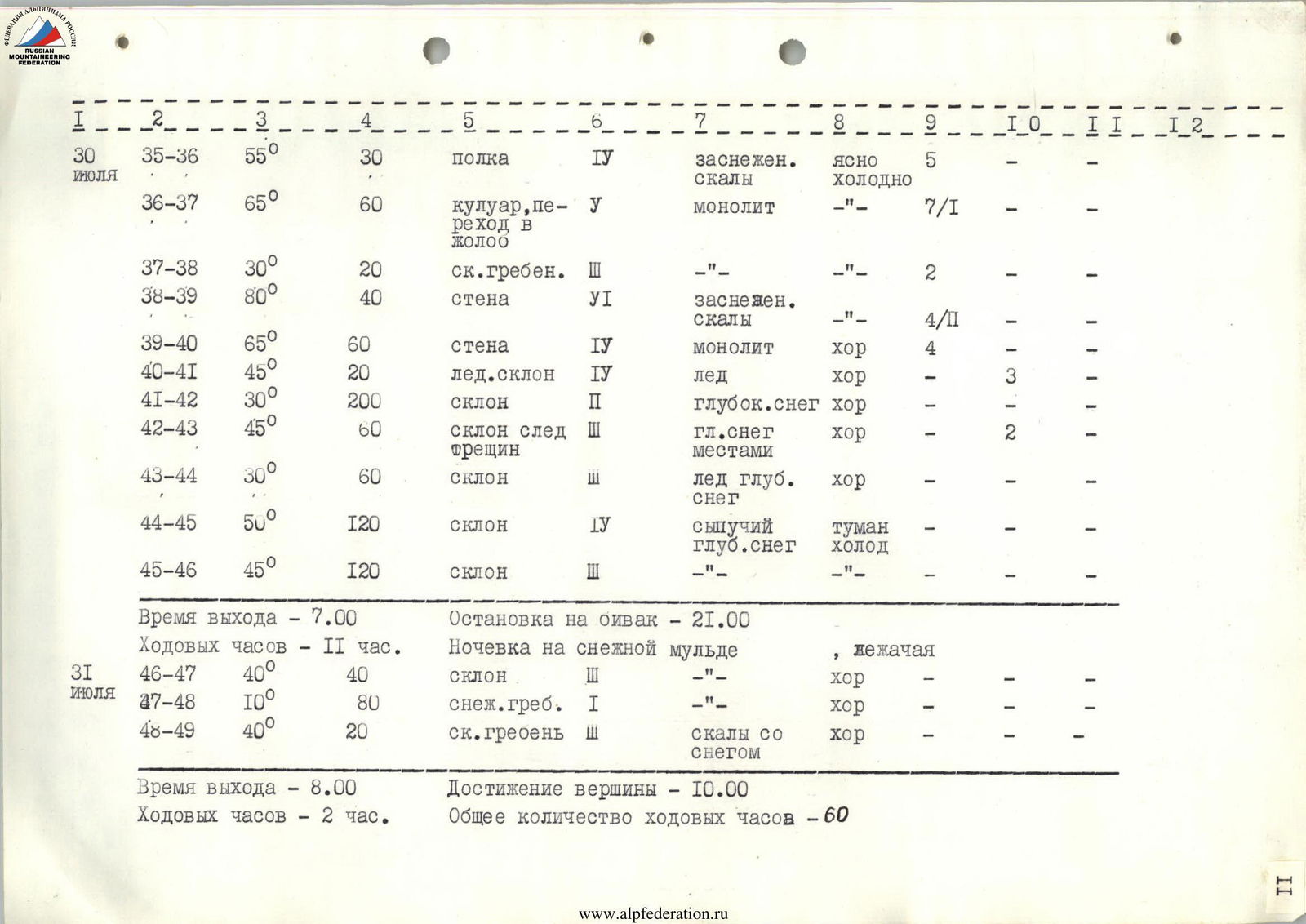
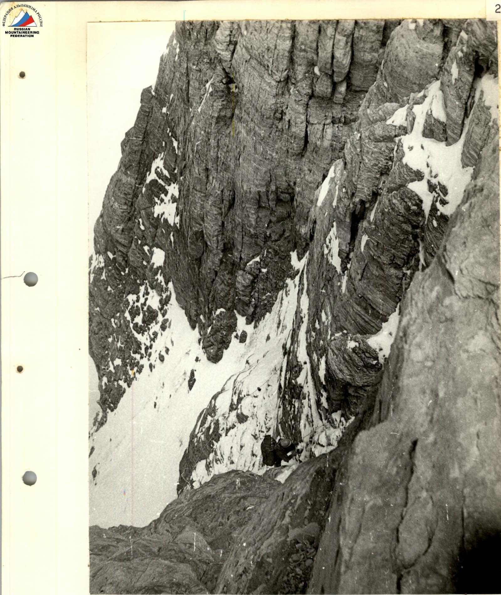
July 26. The first team departs from the bivouac in the intermediate camp on the glacier at 7:00. The day before, the lower ice part of the route (up to section R4–R5 inclusive) was processed for 5 hours. Section R0–R1 is a firn slope with individual ice sections. To the right of the ascent route lies an avalanche outwash from the couloir, which is crossed at its narrowest part (section R1–R2). Snow and ice periodically fall down the couloir, so it needs to be traversed quickly under the protection of ice walls. Further up the steep ice (R2–R3), the ascent leads to a large ice ledge (R3–R4), one of the complex ice sections. It was climbed using front points and ice axes, with artificial aids used in some places. The ice ledge gradually becomes less steep, leading to a gentle ice slope (30°) covered with a thin layer of snow, about 5 cm (R4–R5). Crossing this slope from left to right, the team reaches a system of crevasses (sections R5–R6, R6–R7, R7–R8). There are individual sections of steep ice and short ice walls.
Further up the steep snowy slope (ice base) (R8–R9) to the bivouac, protected by an overhanging ice wall, one of the bergschrunds. After 2 hours of work, places for two tents were carved into the ice. Processing of the section up to R11–R12 inclusive.
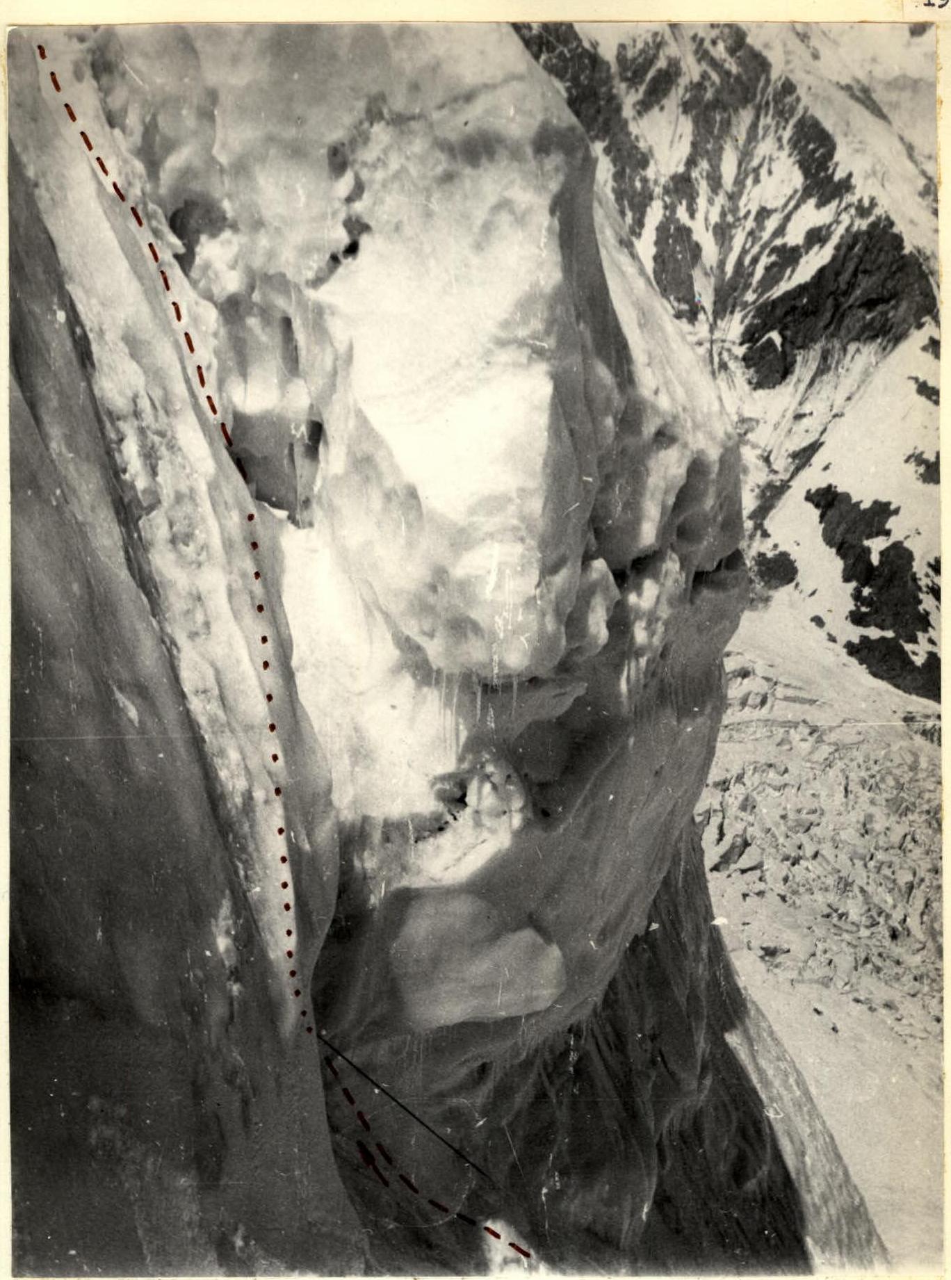
Bivouac stop at 20:00. July 27. Departure on the route at 7:00. From the bivouac, straight up the ice to the rocks (160 m on crampons) (section R9–R10).
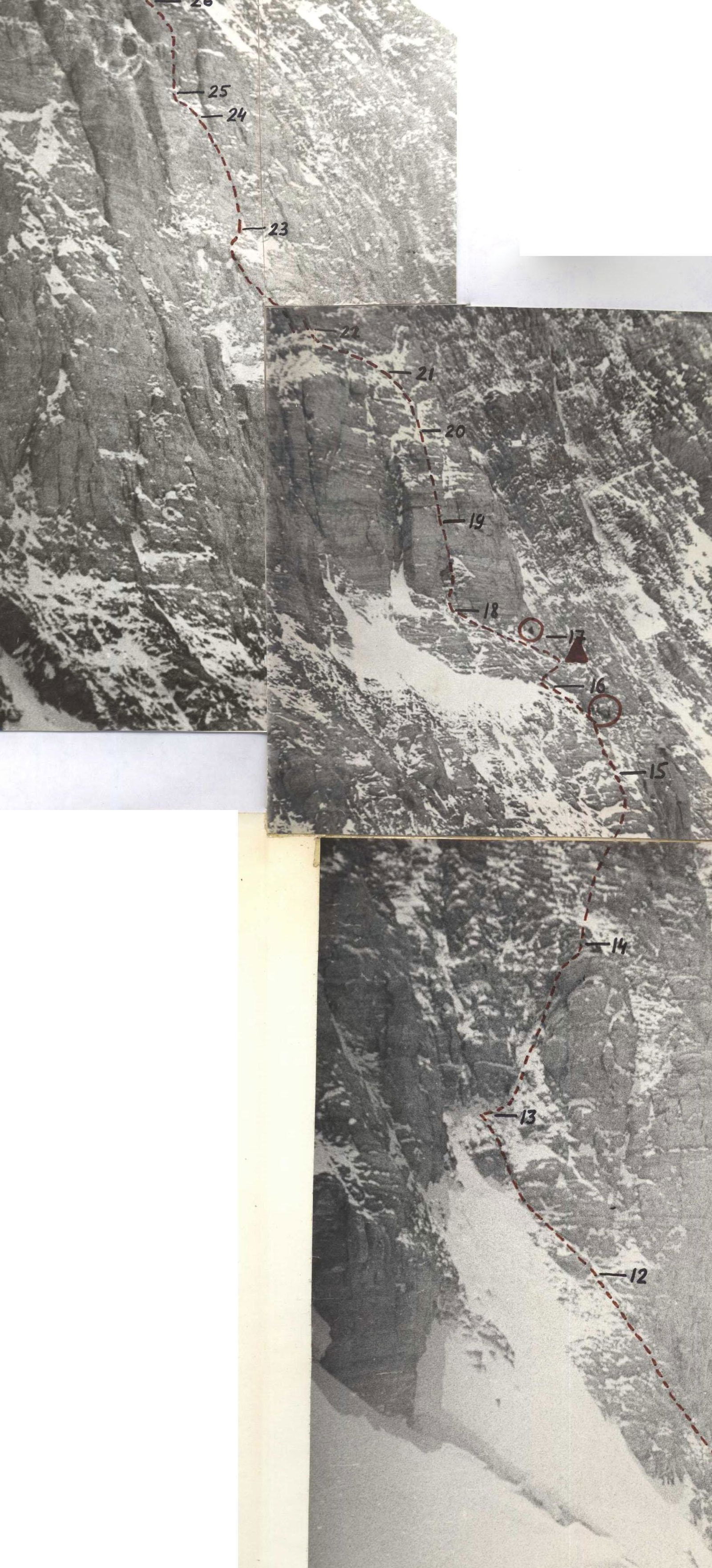
Along the boundary of rocks and ice (R10–R11) with maximum caution, as the rock is destroyed and crumbles underfoot, the ascent goes up and to the right. Further, the steepness gradually increases, and the slope turns into a wall. Then along a poorly defined inclined shelf, up and to the left towards an inner corner (R11–R12).
Approach to the inner corner (R12–R13) along steep, heavily snowy and icy rocks. Up the inner corner — exit to a small shelf where everyone can gather. Further straight up to a 300-meter vertical section of the bastion (R14–R15, R15–R16, R16–R17).
Here the rocks become more solid.
At the end of section R16–R17 — bivouac on a shelf under the key 300-meter section of the bastion.
Processing up to section R22–R23 inclusive.
Bivouac stop at 20:00. July 28. Departure on the route at 8:00. Climbing the bastion begins from the inner corner, to which a poorly defined snowy shelf leads.
- Up the inner corner — complex climbing (R18–R19).
- Further up the wall straight up — 40 m (R19–R20).
- Avoiding an overhang, traverse left and up through a crack — 20 m (R21–R22). Here two people can gather.
- Traversing right along smoothed, icy rocks (R22–R23) — approach to a crack.
- Crack (R23–R24) — partially overhanging, complex climbing on monolithic rocks.
- On section (R24–R25) — unexpectedly very destroyed rocks, where AIDs are used.
- The last section of the bastion from the entire rock part of the route — complex power climbing up a crack (R25–R26).
- Along a slippery ridge of 3rd category (R26–R27) — exit to the bivouac on a wide rock shelf.
Processing up to section R28–R29 inclusive. Bivouac stop — 20:00. July 29. Departure on the route at 8:00. From the bivouac, pressing to the right to avoid the ice fall, along heavily snowy rocks of block structure for 160 m (R27–R28).
Gradually, the rock slope increases in steepness, and the difficulty grows (4–5 diff. cat.).
Further approach to the second bastion (R28–R31), leading to the snow dome. The rocks are monolithic, with snow. Despite the relatively small steepness (55°), the nature of the rocks does not allow for a lying bivouac, and the team has to bivouac sitting, securing the tent with ropes. Setting up the bivouac took a lot of effort and time. Weather conditions worsened, fog, precipitation. Processing up to section R36–R37 inclusive.
Bivouac stop at 20:00. July 30. Departure on the route at 7:00. From the bivouac, along steep, icy shelves, enter a groove crossing almost the entire second bastion (R35–R36). The groove is monolithic, filled with ice, and requires partial use of stemming. From the groove, exit left to a poorly defined ridge (R37–R38) and further up a 40-meter wall — complex climbing. The last 60 m of the approach are directly up monolithic dry rocks (R39–R40). Along hard, frozen ice (R40–R41), exit to the dome. Along snowy slopes of varying steepness (very deep, loose snow) straight up, without cutting the slope. Especially unpleasant is section (R44–R45) due to the large steepness and looseness of the snow, requiring the team to "swim" in the snow. The last bivouac is immediately after exiting to the ridge, 2 hours to the left of the summit in a snow depression. Bivouac stop at 20:00.
July 31. Departure from the bivouac at 8:00. To the summit — 2 hours along a simple snow ridge. Excellent weather. Excellent visibility.
Further to the saddle with peak Leningrad and onto the plateau along the explored descent route.
SECTION R3–R4
SECTION R7–R8
SECTION R13–R14
FIRST ROCK BASTION (photo from the Burvestnik ridge with a telephoto lens)
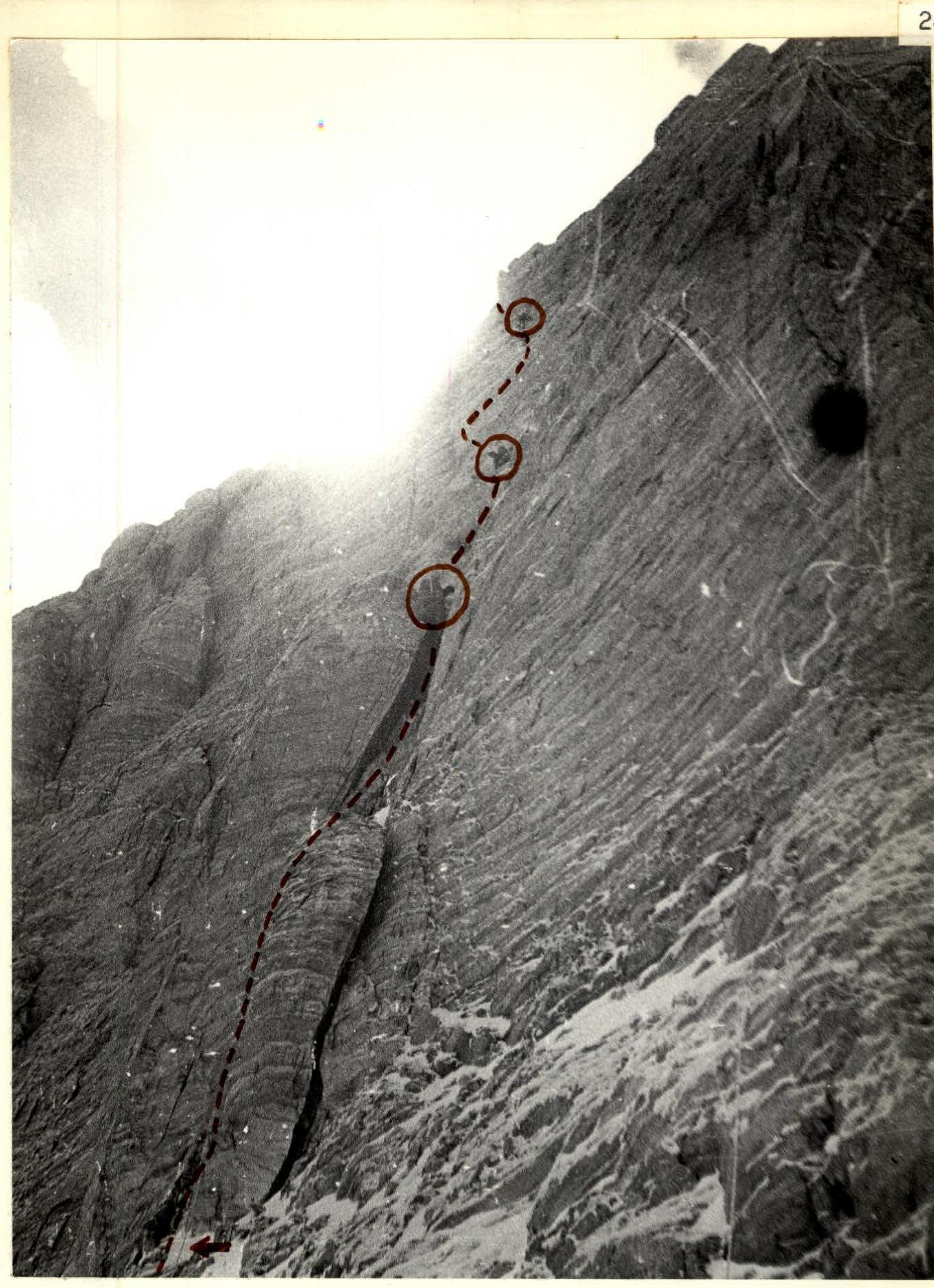
UPPER PART OF THE FIRST ROCK BASTION (sections R18–R19 + R25–R26)
DESCENT ROUTE FROM THE SADDLE BETWEEN P.P. Leningrad AND E. Abalakova TO THE POP