ASCENT PASSPORT
- Ascent class – high-altitude technical.
- Region – Eastern Pamir, Muzkol Range.
- P. 5986 m (Bitkaya Zap.) via the right chimneys and central bastion of the Southwest wall.
- Proposed – 6B category of difficulty, second ascent.
- Height difference – 866 m, route length, including traverses, 959 m, average steepness of the route – 73°. Length of sections with 5–6 category of difficulty – 789 m (5195–5915), including 6 category of difficulty – 514 m (5420–5815, 5850–5900). Steepness of the wall part of the route – 78° (5195–5915).
- Number of pitons used:
| rock | bolt | chocks | ice |
|---|---|---|---|
| 114 | 23 | 178 | 2 |
| 62 | 18 | 68 | 0 |
- Team's total climbing hours: 52 hours and days: 5.
- Night bivouacs:
- 1–3 – 6 people in a tent, 2 in hammocks
- 4 – 6 people in a tent, 2 in hammocks (separate)
- Team leader: Mikheev Alexander, Candidate Master of Sports.
Team members:
- Gostishchev Sergey, Candidate Master of Sports
- Muchkin Alexey, Candidate Master of Sports
- Perminov Valery, Candidate Master of Sports
- Pudlovsky Oleg, Candidate Master of Sports
- Pupryev Konstantin, Candidate Master of Sports
- Sedusov Boris, Candidate Master of Sports
- Khusainov Ralif, Candidate Master of Sports
- Coach: Sedusov B.A., Candidate Master of Sports, 2nd sports category.
- Departure to the route: July 28, 1991. Summit: August 1, 1991. Return: August 1, 1991.
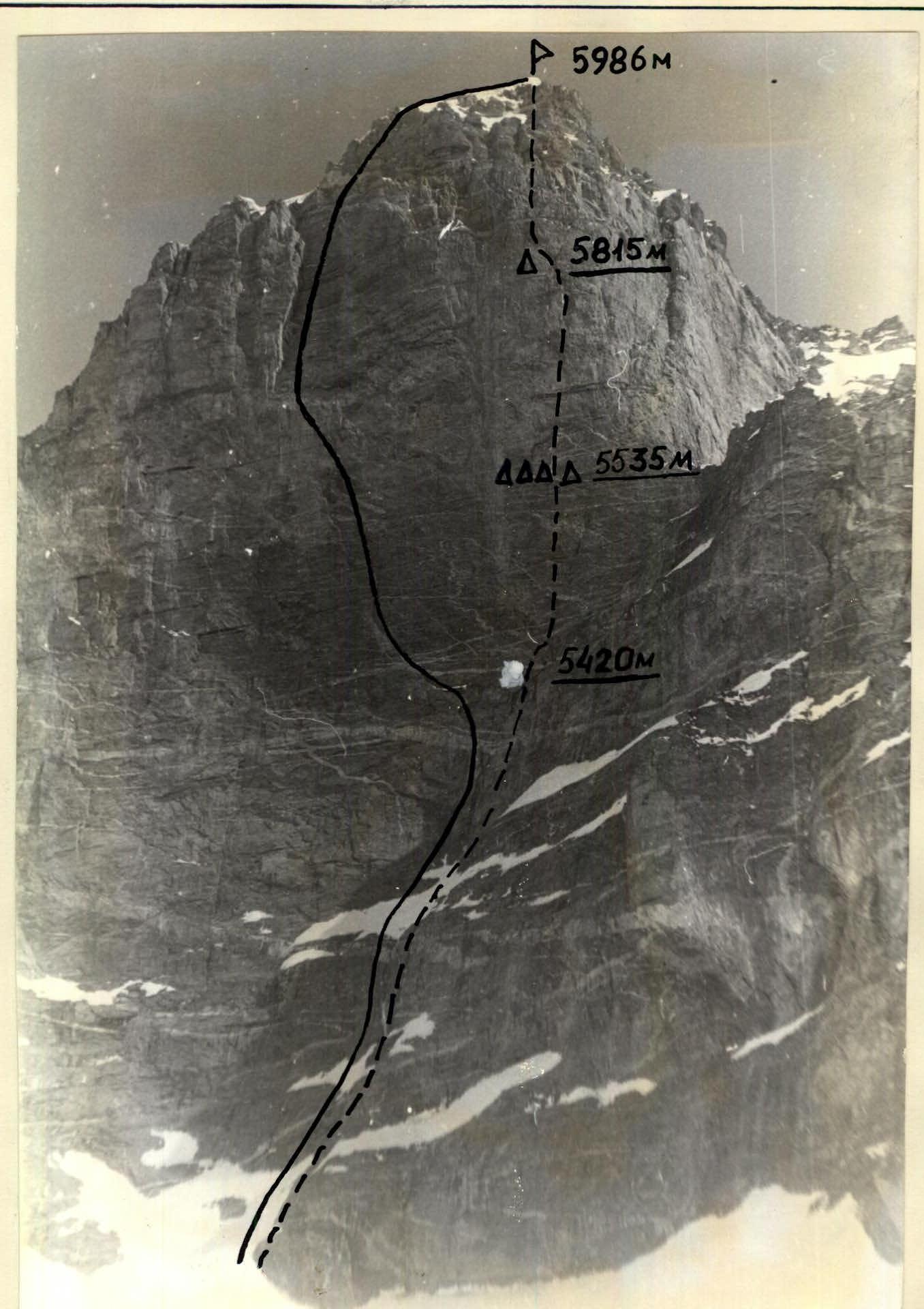
Photo #1. General photo of the summit Bitkaya Western — “V. Jak route – first ascent 1986”. “—” Ostanin route, climbed by the team. Shooting point #3. Camera “Smena-simvol”, lens T-43 F-40 mm.
AREA MAP-SCHEME

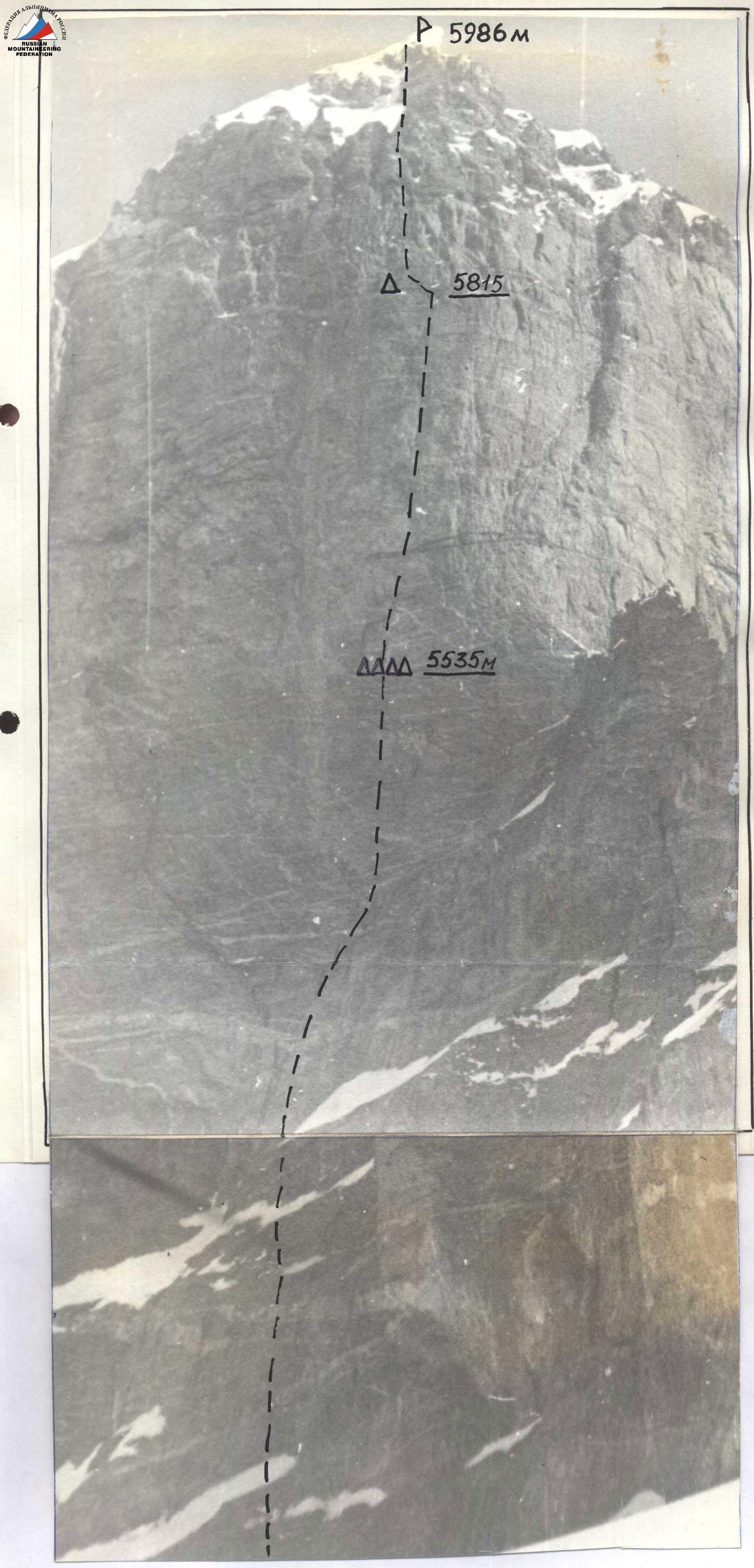
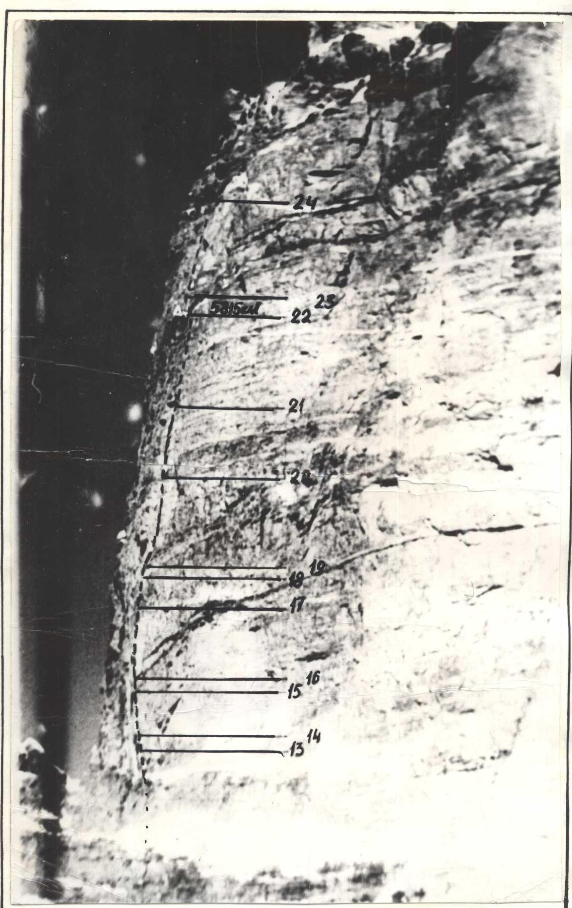
Photo 2. Profile of the wall on the right. Lens “Mir-1V” F-36. Distance 0.6 km. Height 5200 m. Shooting point #2. (On the left, a blurry strip near the edge of the sheet is a plumb line).
PREPARATION FOR THE ASCENT
The Bitkaya Zap. peak attracted the team's attention after studying the results of the USSR Championships in the high-altitude technical class.
A plan was developed to prepare the team for the championship, which included:
- joint year-round training;
- team participation in rock climbing competitions in the Perm region;
- a two-week training camp in Yalta, where they climbed routes of the highest category of difficulty on the Foros wall.
The team also had experience with complex rock climbs in previous years.
To become more familiar with the route to v. Bitkaya Zap., the team received a detailed consultation from the first ascensionists, the team RSFSR-I from Sverdlovsk.
On July 16, the team arrived by helicopter in Dushanbe, in the valley of the Sauksay River, along with a rescue team. They set up a base camp at an altitude of 3650 m (one hour's walk above the Sverdlovsk campsite from 1989). Then the team made an acclimatization ascent to the Bitkaya Zap. glacier with two night bivouacs to study the route in detail and take photographs.
After a two-day rest at the base camp, the team set out on the ascent. To obtain detailed information, radios of the "Kaktus" type were prepared, and subsequently, communication was established between the rescuers on the Bitkaya Zap. glacier and the base camp. A radio station "ANGARA" was set up at the base camp to communicate with Dushanbe and in case of an emergency helicopter call.
| 25 | 24 | 23 | 22 | 21 |
|---|---|---|---|---|
| 23 | 22 | 21 | 20 | 19 |
| 18 | 17 | 16 | 15 | 14 |
| 13 | 12 | 11 | 10 | 13 |
| 10 | 11 | 10 | 9 | 8 |
| 7 | 6 | 5 | 4 | 3 |
| 6 | 5 | 4 | 3 | 2 |
| 4 | 4 | 3 | 2 | 1 |
BRIEF OVERVIEW OF THE ASCENT AREA
Until 1986, the area of the Muzkol Range (valleys of the Zam, Pshart, and Sauksay rivers) was a "blank spot" for mountaineers.
The Muzkol mountains are the most poorly studied part of the Eastern Pamir. Rising in the form of powerful ridges with a highly dissected ridge line and numerous glaciers, they present a sharp contrast against the background of relatively gentle, rounded, and snowless mountains of the Eastern Pamir.
In the eastern part of the Muzkol Range, i.e., in the area where the expedition worked, are the highest peaks in the region – so II peaks have a height of over 6000 m. The highest point in the area is p. Sov. Ofitserov (6233 m).
The object of the ascent is located in the upper reaches of the Sauksay River valley, on the Zap. Bitkaya glacier, which, like most of the Muzkol glaciers, has a relatively gentle slope (300–350 m over a length of 5–6 km) and a snow line at 5000–5100 m. This circumstance determines one of the features of ascents in this area, where most routes to the peaks are located in the altitude range of 5000–6000 m. However, the most characteristic feature of the area is its belonging to high-altitude deserts, making the climatic conditions of Muzkol harsh and difficult for life. Muzkol is considered a very dry place, characterized by extremely low humidity (on average about 16%), low precipitation (on average 70–80 mm per year), and large diurnal temperature fluctuations. At the same time, it should be noted that the summer of 1991 was anomalous and not typical for Muzkol in terms of weather conditions. For example, out of 24 days of the expedition's work in the area, only a few periods of stable clear weather lasting 3–5 days were recorded. The rest of the time, precipitation was observed. Such weather conditions led to a relatively high level of snow cover.
The Bitkaya massif, on whose western peak the ascent was made, is characterized by the presence of powerful walls, the most steep and extensive of which is the Southwest wall on peak 5986 m (Bitkaya Western). It hangs over the glacier like a huge well, striking with its brightness and steepness.
The trip to the ascent area was made from Dushanbe by helicopter to the Sauksay River valley, where a first base camp was set up at an altitude of 3650 m. The upper (main) base camp was established under the Sauksay glacier, 3–4 hours' walk from the first one, at an altitude of 4700 m. From this location, it takes about three hours to walk to the start of the route. A feature of the approach is the presence of narrow canyons with pinches, which typically cannot be bypassed from above, forcing frequent crossings of the main riverbeds.
Communication with Dushanbe (KSP) was carried out using a radio station of the "ANGARA" type twice a day:
- at 8:00
- at 20:00
ROUTE SCHEME IN UIAA SYMBOLS
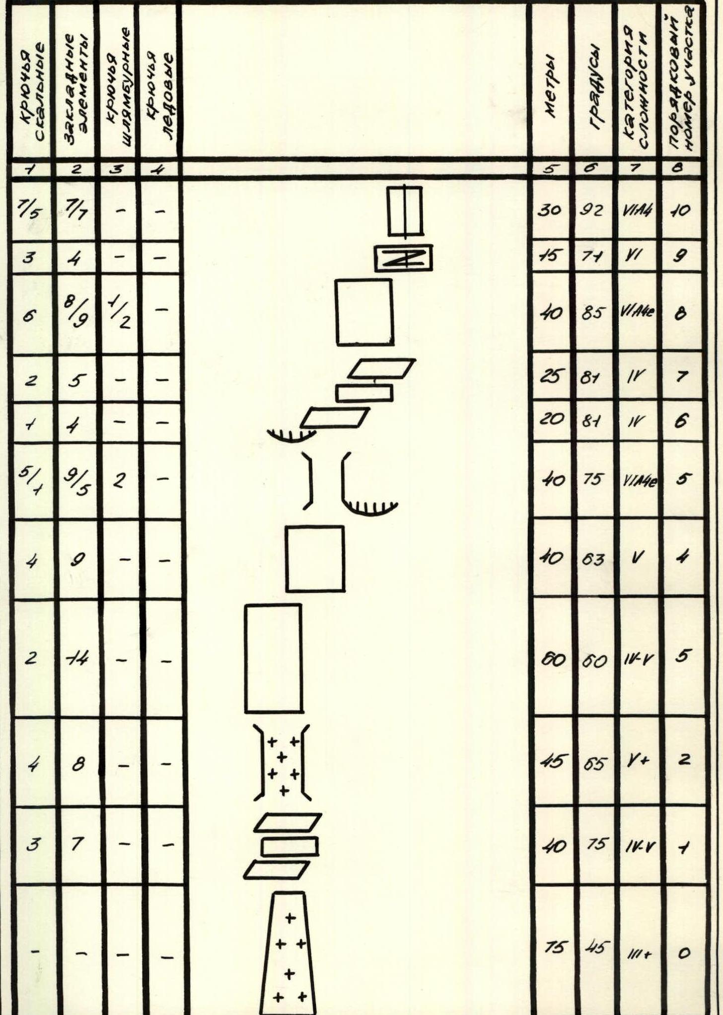
| rock pitons | Chocks | bolt pitons | ice pitons | meters | degrees | category of difficulty | section number | |
|---|---|---|---|---|---|---|---|---|
| Total climbing hours 52 | ||||||||
| 114 | 178 | 23 | 2 |  | 923 | R26 | ||
| 4 | 11 | - | 2 |  | 80 | 58 | IV+ | R25 |
| 3/2 | 7/2 | - | - |  | 40 | 76 | IVA4 | R24 |
| 2 | 12 | - | - |  | 40 | 78 | V+ | R23 |
| 4 | 5 | - | - |  | 20 | 80 | V+ | R22 |
| 2 | 10 | - | - |  | 40 | 82 | VI | R21 |
| 9/4 | 4/6 | - | - |  | 40 | 79 | VIA4 | R20 |
| 6/5 | 9/3 | 1 | - | 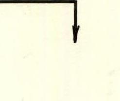 | 40 | 86 | VIA4 | R19 |
| 5/3 | 2/2 | 1 | - | 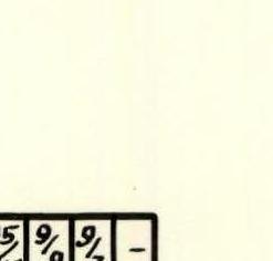 | 8 | 92 | VIA4 | R18 |
| 8/8 | 9/8 | 3/3 | - |  | 20 | 88 | VIA4E | R17 |
| 3/3 | 4/4 | 1/1 | - | 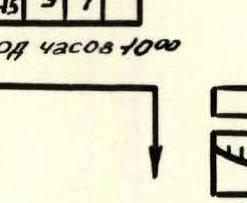 | 19 | 86 | VIA4E | R16 |
| 5/5 | 4/4 | - | - | 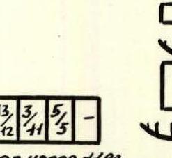 | 10 | 94 | VIA4E | R15 |
| 6/6 | 4/4 | 3/2 | - |  | 20 | 84 | VIA4E | R14 |
| 9/9 | 5/5 | 6/5 | - |  | 25 | 93 | VIA40 | R13 |
| 6/6 | 3/3 | 3/3 | - |  | 20 | 94 | VIA40 | R12 |
| 8/6 | 10/8 | 2/2 | - |  | 40 | 92 | VIA40 | R11 |
| 7/5 | 7/7 | - | - |  | 30 | 92 | VIA4 | R10 |
DESCRIPTION OF THE ROUTE BY SECTIONS
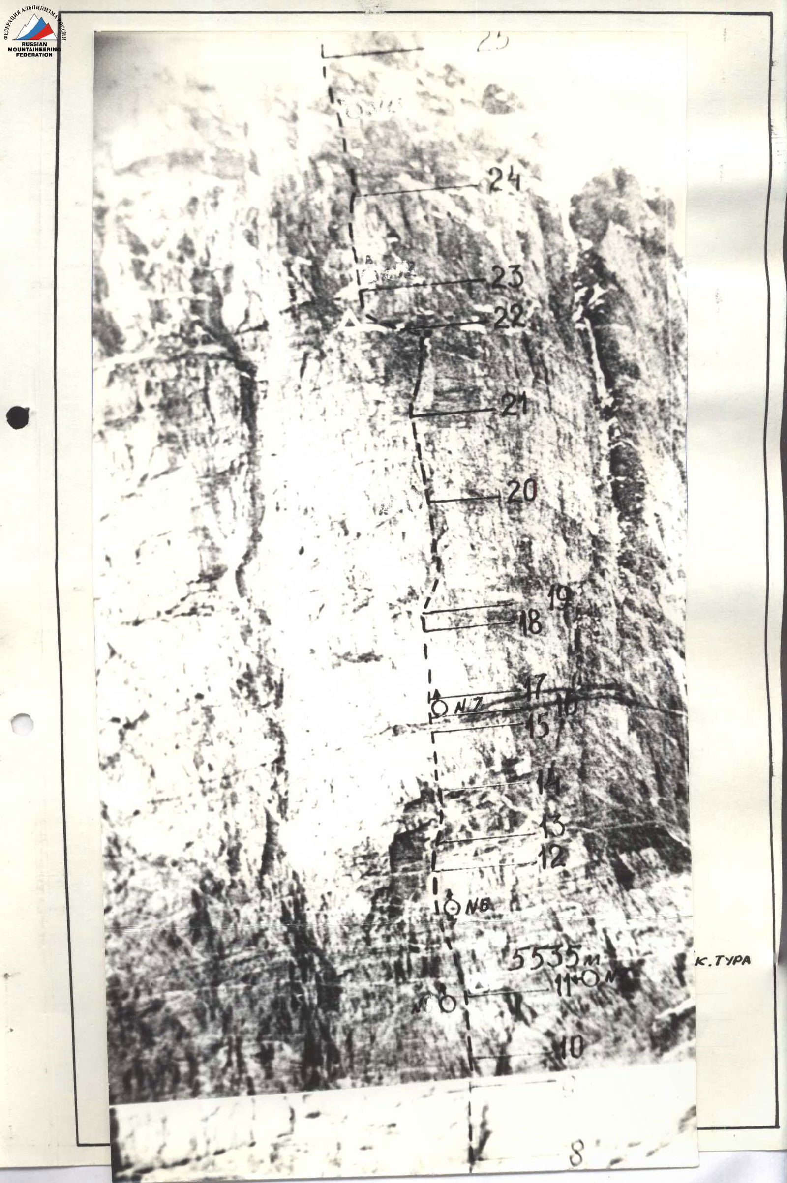
R0–R1: Snow-ice slope. Movement by independent rope teams. R1–R2: Not very steep but highly smoothed rocks. R2–R4: Movement in a chimney. Rime ice. R4–R5: Movement upwards to the left, bypassing the overhang, in the direction of the chimney. R5–R6: Inclined chimney, the left wall overhangs. The relief is fragile, brittle. R6–R7: Gentle ledges (bivouac #1 under the overhang). R7–R8: Cracks, but the steepness increases. R8–R9: Series of lateral outcrops. Difficult to organize reliable protection. R9–R11: Movement along a crack, the upper half overhangs, but ends with a good ledge with an "outcrop". R11–R12: Bivouac on the ledge, first control point. R12–R13: Smoothed monolithic rocks, colored with marble veins. R13–R14: Lateral collapses and collapses directed downwards, almost all "blind". Movement in the collapse of cornices. R14–R15: The cornice is passed along inclined cracks, then upwards in the direction of the "black vein". R15–R16: "Puzo". No relief. R16–R17: Series of cracks for leaf-shaped pitons. R17–R18: Movement up the slab. R18–R19: Under a large cornice. R19–R20: Logical deviation to the right, behind the edge of the bastion. Relief appears for free climbing. R20–R21: Not clearly visible vertical inner corner. R21–R22: Exit to the right of the "balcony". The lower part of the wall is heavily destroyed. R22–R23: Caution! Bands of sandy sediments. Difficulty in organizing reliable protection. R24–R25: Movement along rocks covered with ice in the direction of the summit. R25–R26: Exit to the ridge through a snowy cornice. Summit.
The team's movement on the route was carried out according to the tactical plan. The route was completed in five days.
1st day. According to the tactical plan, the lower part of the wall and three ropes of the bastion were passed. Exit and organization of a bivouac in the area of the "Ochki" ledge (2nd bivouac of the RSFSR-I team). The lower part of the wall was climbed by the Gostishchev–Pupyrev rope team (sections R0–R7, photo 5).
In the second half of the day, Mikheev A. worked on processing (sections R8, R9, R10; photo (A)).
By 19:00, the team had fully ascended to the ledge for the bivouac. They improved the site for the tent, which was made by the Sverdlovsk team in 1989. There were no issues with drinking water. There was sufficient ice on the ledge. The width of the site for the tent was 1.5 m, the length 2.0 m. The site is under a large cornice, ensuring safety. Six people slept in the tent, and two others were hung in hammocks.
2nd day. They began processing the "mirror". Following the Sverdlovsk team's recommendation and knowing about the very high complexity of the rocks, they used a wide variety of rock climbing equipment (sky hooks, expanding bolts, bolts with cables). They also used pitons and chocks where possible. Gostishchev, Pupyrev, and Mikheev worked ahead in turn (sections R11 and R12, photo (B)). The steepness of the rocks was such that the lower end of the fully hung rope was five meters away from the rock.
3rd day. Continuing to process the "mirror". The Gostishchev–Mikheev rope team worked ahead. Sections R13, R14, R15, R16 were passed (photo 7).
4th day. After analyzing the situation, the team decided to act according to the Sverdlovsk team's plan. The Mikheev–Gostishchev rope team, taking a minimum of bivouac equipment, went to process the route to reach the ledge near the second control point. By 18:00, the rope team climbed to the upper part of the wall to a ledge in the area of the second control point of the Sverdlovsk team.
5th day. At night, heavy snowfall began. Wind, fog. Therefore, the team started early, at 6:00. They quickly caught up with the rope team via the hung ropes. It was decided not to search for the 2nd control point but to climb higher. The steepness of the rocks decreased, and the rocks became simpler. The Perminov–Khusainov rope team worked ahead (sections R22–R25). By 15:00, the team, observing all safety measures, reached the summit of Bitkaya Western in full.
Thus, the ascent was completed despite two days of bad weather. The challenging route was completed without deviating from the planned plan. Moreover, on the first and fifth days, the team demonstrated their speed "from the sheet", and the "mirror" of the bastion was climbed using a siege tactic, which helped conserve the team's strength.
On a good bivouac site, the leaders rested and recovered. The bad weather was not a threat in a double high-altitude tent, and those who processed the route came back to hot tea and a hot meal. Work on the route was carried out in a 10–11 hour mode (including processing) and 8 hours of rest daily. The route took 52 hours. The safety of the ascent was ensured by the correct choice of route:
- since the bastion is somewhat distant from the wall, rocks and ice fall to the right and left;
- the presence of convenient bivouac sites on the route, provided with ice;
- regular change of leaders by days and within a single day (6 out of 8 team members worked first);
- work of the first climber only on a double rope with UIAA-I belay and an absorber using a wide range of equipment, including sky hooks, hook-nogi, etc.;
- passing of fixed ropes with double belay;
- securing of fixed ropes and organization of bivouacs in places protected from rockfall.
The team had:
- a set of medications necessary for emergency assistance;
- two primus stoves ("Shmel-2" and "Ogonyok") to guarantee continuous operation and for separate bivouacs;
- a radio station of the "Kaktus" type.
Hot meals were prepared twice a day, with a "snack" provided for the day. On bivouacs, in addition to two meals during the day, hot drinks were prepared.
During the ascent, a rescue team (list in the appendix) with the right to climb routes of 6 category of difficulty was present in the observers' camp or at the 4700 m camp. During the ascent, all waste was burned or taken away. The route was left clean, all pitons were removed, and bolts were unscrewed. There were no accidents or injuries on the route.
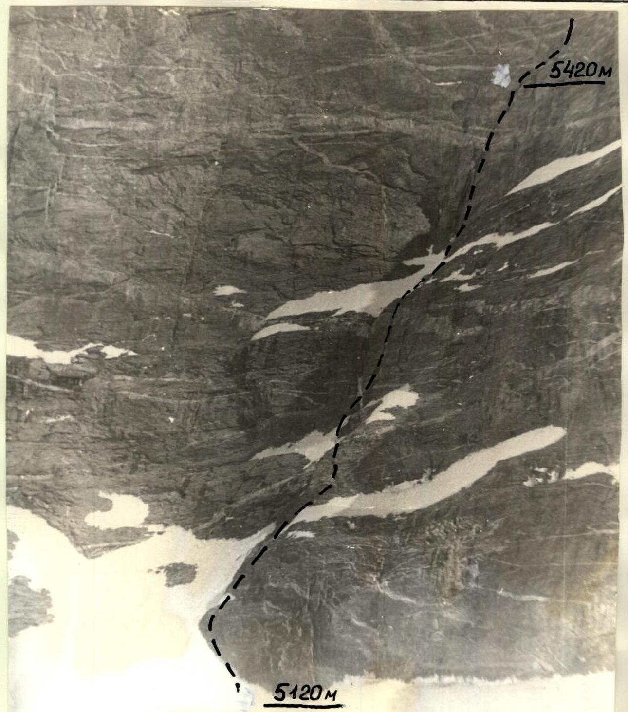
Photo 5. Beginning of the route. Sections R0–R7. Shooting point #4. Camera “Smena 8”. Lens T-43; F-40 mm.