
Ascent Passport
I. Ascent category — first ascent. 2. Region — Eastern Pamir, Muzkol Range. 3. Height 5986 m (Bitkaya Western) via the mirrors of the Western wall. 4. Proposed — 6B category of difficulty, first ascent. 5. Height difference — 906 m, route length (including traverses and detours) — 1025 m. Average steepness of the route — 79°. Length of sections with 5–6 category of difficulty — 925 m, including 6 category of difficulty — 765 m (35 m, 5235–5270 m), (730 m, 5285–5950 m). Steepness of the main part of the route — 86° (5235–5950 m). 6. Pitons driven:
| rock | bolt | chocks | ice | |
|---|---|---|---|---|
| total | 118 | 13 | 145 | 7 |
| for ITO | 67 | 13 | 88 | 0 |
- Team's working hours: 87.25, and days — 8.
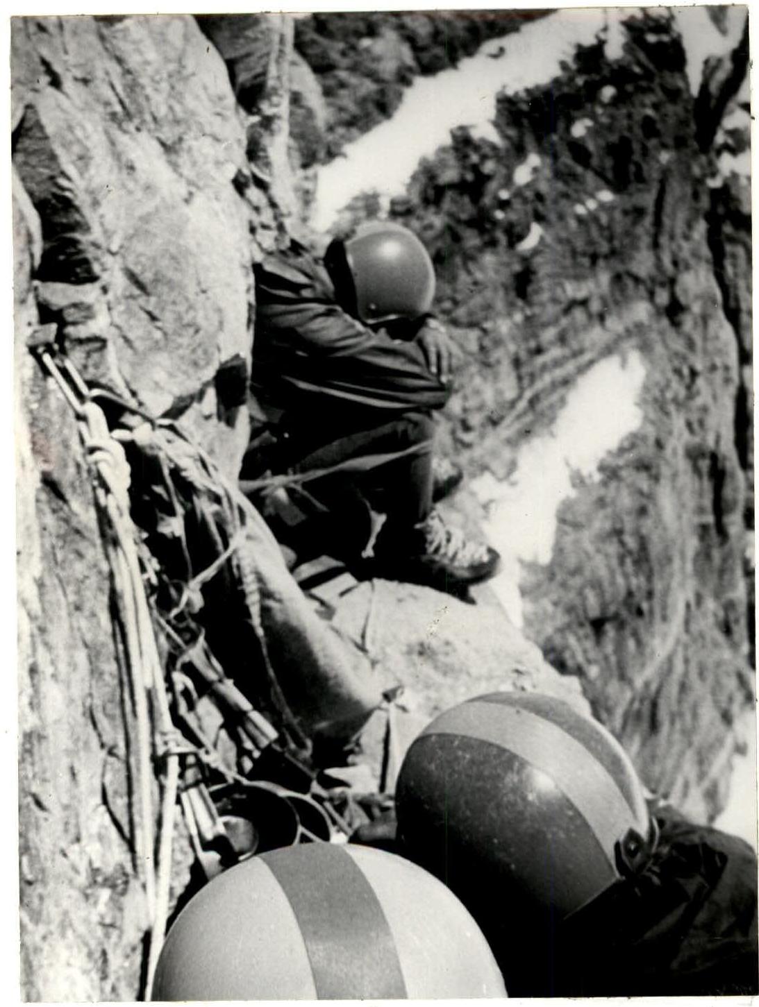
- Overnights: 1st–7th — hanging in hammock-tents.
- Team leader: Zhak Viktor Vladimirovich, Master of Sports Team members:
- Aivazov Mikhail Borisovich, Master of Sports
- Glushkov Alexander Semenovich, Master of Sports
- Ivanov Nikolai Rufovich, Master of Sports
- Ovsyannikov Dmitry Alexandrovich, Master of Sports
- Semiletkin Sergey Alekseevich, Candidate for Master of Sports
- Sokolov Valery Anatolyevich, Candidate for Master of Sports
- Coach: Dzhibrayev Yuri Georgievich, Master of Sports.
- Approach to the route: July 28, 1986. Summit: August 4, 1986, 1:00 PM. Return: August 4, 1986.
Brief overview of the ascent region
Until 1986, the Muzkol Range region (Zapadny Pshart and Sauksay river valleys) was a "blank spot" for climbers. Our expedition was the first climbing event in the region. The Muzkol mountains are the least explored part of the Eastern Pamir. Rising in the form of powerful ridges with a highly dissected ridge line and numerous glaciers, they present a sharp contrast against the background of relatively gentle, rounded, snowless mountains of the Eastern Pamir. In the eastern part of the Muzkol Range (i.e., in the area where the expedition worked), the highest peaks in the region are located — two peaks have a height of over 6000 m. The highest point in the region, Pik Sovetskikh Ofitserov (6233 m), is also located here. The ascent object is located in the upper reaches of the Sauksay river valley, on the Zapadny Bitkaya glacier, which, like most Muzkol glaciers, has a relatively gentle slope (300–350 m over a length of 5–6 km) and a snow line height of 5000–5100 m. This circumstance determines one of the features of ascents in the region, where most routes to the peaks are located in the altitude range of 5000–6000 m. But still, the most characteristic feature of the region is its belonging to high-altitude deserts, making the climatic conditions of Muzkol harsh and difficult for life. Muzkol is characterized by:
- extremely low humidity (on average about 16%);
- low precipitation (on average 70–80 mm per year);
- sharp diurnal temperature fluctuations. At the same time, it should be noted that the summer of 1986 was anomalous and uncharacteristic for Muzkol in terms of weather conditions. For example, out of 45 days of the expedition's work in the region, only two periods of stable clear weather were recorded — 4 and 6 days. Precipitation was observed on other days. This weather pattern resulted in a relatively high level of snow cover. The Bitkaya massif, on whose western peak the ascent was made, is characterized by the presence of powerful walls, the most steep and extensive of which is the Western wall at a height of 5986 m (Bitkaya Western). It towers like a huge well over the glacier, striking with its smoothness and steepness. The well-like shape of the Western wall determines its relatively late sunrise and early sunset. The sunny day on the wall lasts from 12:00 to 18:00. The trip to the ascent region was made from Murgab city by car through the Aktash pass (4300 m) to the Zapchadny Pshart river valley — about 50 km from Murgab. Then downstream along Zapadny Pshart to its confluence with the Sauksay river, where the first base camp was established at an altitude of 3550 m. The upper (main) base camp was set up under the Sauksay glacier in 4–5 hours' walk from the first one, at an altitude of 4200 m. It takes about 3.5 hours to walk from this location to the start of the route. A feature of the approach is the presence of narrow canyons with pinches, which are usually not passable from the top, forcing frequent crossings of the main riverbeds (for example, when moving along the Zapadny Pshart gorge, which is about 5 km long, we had to cross the river 15 times). Communication with the "outside world" from the expedition's work area is possible from the Zapadny Pshart weather station, which opened in 1986. The path to the weather station from the 1st base camp took us 4 hours. The weather station maintains regular (3 times a day) radio communication with Dushanbe and Rushan. The weather station is supplied by helicopter. The weather station is located 3 km below the confluence of the Zapadny Pshart and Murgab rivers.
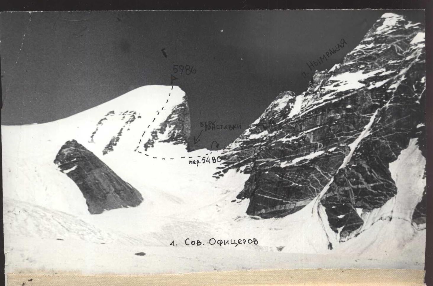 №2. Profile of the wall on the left. Taken in 1985 with a "Smena" camera lens, from a distance of about 3.5 km, shooting point on diagram №2, shooting height 5450–5500 m. The upper part of the "attachment" is visible behind the pass (5480 m).
Tactical actions of the team
The team's movement on the route was carried out in accordance with the tactical plan, in the mode of 11–13 hours of work and 8 hours of rest. Daily (except for the 1st and 5th days of the ascent), a "pair" processed the route above the next overnight stay, which ensured "warm-up" and "preparation" for the leading rope team's movement the next day. Despite the harsh weather conditions on the 7th and 8th days of the ascent and the extremely complex, previously unseen by the team, nature of the rocks on the route, the tactical plan was fully implemented (taking into account the use of reserve days). The team spent 87 working hours on the route. The safety of the ascent was ensured by:
- regular (daily) change of leading rope teams and leaders in the teams;
- passage of the route only on belay;
- work of the first on two foreign ropes and with a shock absorber. Fixing of the ropes was organized in places protected from possible rock and ice fall (due to the great steepness of the wall, rare rocks and ice fly 15–20 m away from the wall). The team had:
- 2 sets of first-aid kits (one of which was always with the leading rope team);
- 2 primus stoves;
- radio communication with a spare power supply. The widespread use of "skyhooks" and ultra-thin "petals" and chocks allowed the team to pass the extremely complex route using only 13 bolt pitons. For overnight stays, the team used hammock-tents, which enabled separate overnight stays. All overnight stays on the route were hanging. The implementation of the tactical plan was carried out as follows:
1st day. Main task — reaching the "birdie" outcrop. Glushkov–Zhak–Ivanov worked ahead. Key places — a 35-meter sheer icicle and sheer rocks with rime ice before reaching the "birdie". 1 bolt piton was driven. Start of work — 8:30 AM, end — 9:30 PM. Ill. 1, 2, 3, 4, 5, 14, 15.
2nd day. Main task — overcoming the system of cornices above the internal angle, reaching the 1st "mirror". Leading rope team — Ovsyannikov–Aivazov. Sections R12–R16 were passed. Extremely complex climbing, 1 bolt piton was driven. Overnight stay on the "birdie". Start of work — 9:00 AM, end — 8:30 PM. Ill. 6, 7, 8, 9, 10, 14, 15.
3rd day. Main task — reaching a cornice on a giant overhang. Leading rope team — Zhak–Glushkov. Extremely complex climbing, when reaching the overhang — only on ITO. 6 bolt pitons were driven. Sections R16–R19 were passed. Overnight stay on the "birdie". Start of work — 9:00 AM, end — 8:30 PM. Ill. 12, 13, 14, 15, 16.
4th day. Main task — passing the cornice on the overhang. Leading rope team — Ivanov–Semiletkin. 5 bolt pitons were driven. Sections R19–R20 were passed. Climbing only on ITO. The rock excludes the wide use of bolt pitons — the wall is covered with a plate-like layer (up to 1.5 cm), which flakes off when working with a drill. The main time is spent on organizing belay. Work on micro-cracks. 2 pendulum movements were made in search of a bypass for the cornice. No bypass was found. Start of work — 8:45 AM, end — 7:00 PM. Separate overnight stay at the base of the overhang. Ill. 10, 11, 15.
5th day. Main task — reaching the "poker" outcrop. Leading rope team — Glushkov–Zhak. Sections R20–R24 were passed. Bolt pitons were not used (see 4th day). Climbing only on ITO. Wide use of "skyhooks". The most complex section of the route. Start of work — 9:00 AM, end — 9:00 PM. Overnight stay on the "poker". Ill. 17, 18.
NOTE. The 3rd, 4th, and 5th days of the route were the most complex and tense in the team's many years of practice.
6th day. Reaching the base of the gap in the quartz vein along the overhanging wall — the main task of the day. Leading rope teams — Aivazov–Ovsyannikov, Aivazov–Sokolov. Sections R24–R27 were passed. Extremely complex climbing, a lot of ITO. The surface of the rock and the edges of the cracks are clogged with granite "dust", the cracks are mostly "blind". Start of work — 9:00 AM, end — 8:30 PM. Overnight stay on the "poker". Ill. 19, 20, 21.
7th day. Main task — reaching a ledge under the summit tower through a large cornice. Leading rope team — Ivanov–Semiletkin. Sections R26–R34 were passed. Extremely complex climbing, a lot of ITO. Start of work — 8:30 AM, end — 9:30 PM.
8th day. Main task — reaching the summit, descending to the base camp. Leading rope team — Ovsyannikov–Ivanov. Climbing from complex to extremely complex. A system of slabs covered with ice. Unstable rocks, "dust". Start of work — 8:00 AM, end (summit) — 1:00 PM. Ill. 24, 25.
On the 1st, 7th, and 8th days of the ascent, there was snowfall and cloudiness. There were no falls or injuries on the route. There were no missed radio communication sessions.
- On the 1st day, bad weather from 8:30 AM to 11:30 AM.
- Ill. 22, 23.
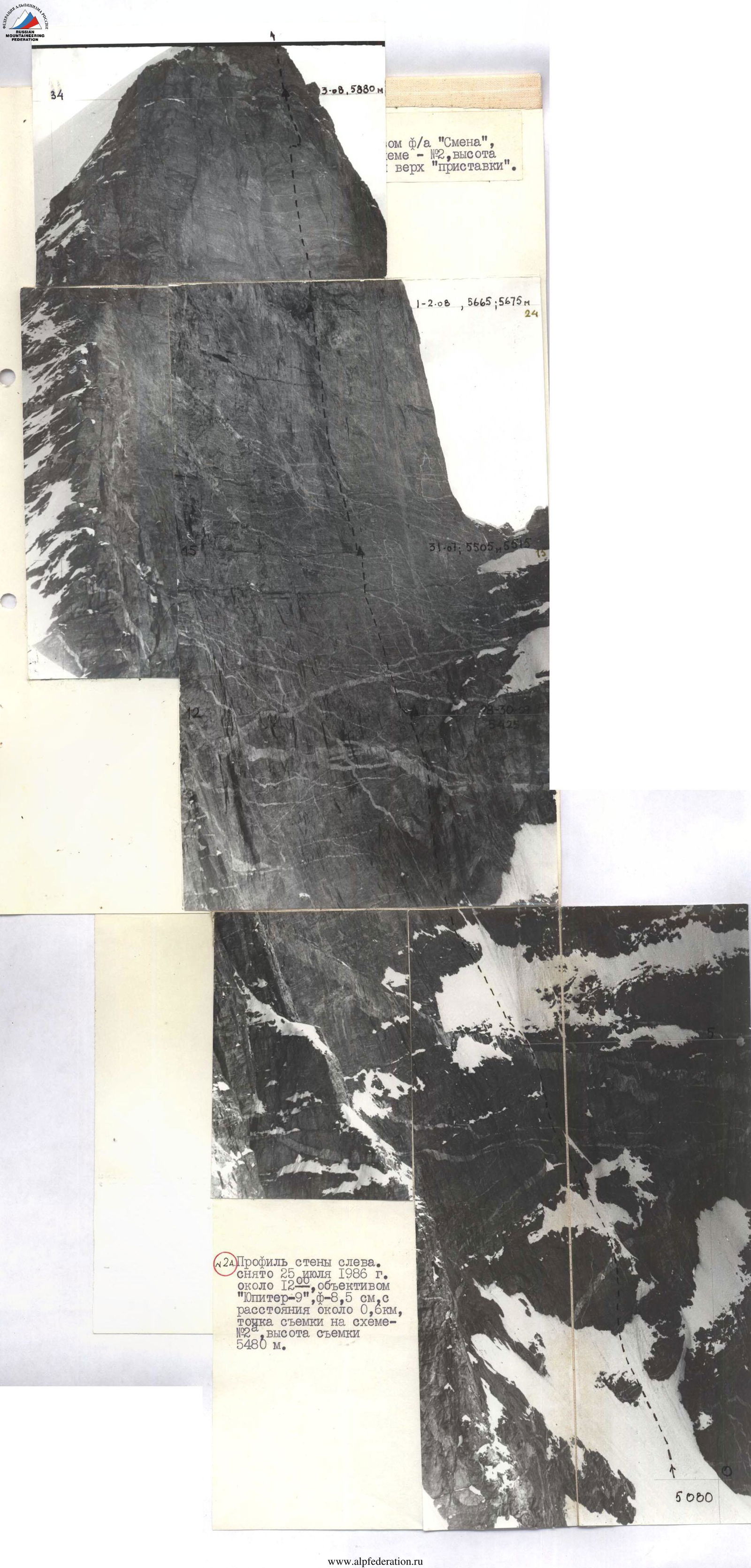
№3. Profile of the wall on the right. Taken on July 27, 1986, at 2:00 PM, with a "Triopлан" lens, f–5 cm, from a distance of 1.5 km, shooting point on diagram №13, shooting height 5250 m. The upper part of the wall profile on the right is shown on the upper collage. Photo from section R24–R25. INVISIBLE PART OF THE ROUTE
ROUTE DIAGRAM ON V. 5986 (BITKAYA WESTERN) VIA THE MIRRORS OF THE WESTERN WALL IN SYMBOLS

| Section | Length (m) | Steepness (°) | Category of difficulty | Rock pitons | Chocks | Bolt pitons | Ice pitons |
|---|---|---|---|---|---|---|---|
| R0 | 60 | 55 | 4 | - | - | - | - |
| R1 | 40 | 65 | 5 | 3 | 2 | - | - |
| R2 | 40 | 55 | 5 | 4 | 1 | - | - |
| R3 | 35 | 90 | 6 | 2 | 1 | - | 3 |
| R4 | 20 | 60 | 5 | 1 | - | - | - |
| R5 | 20 | 75 | 6 | 1 | 2 | - | - |
| R6 | 20 | 60 | 5 | - | - | - | - |
| R7 | 45 | 85 | 6 | 3 | 4 | - | - |
| R8 | 10 | 105 | 6 | - | 1 | 1 | - |
| R9 | 25 | 85 | 6 | - | 4 | - | - |
| R10 | 45 | 85 | 6 | 3 | 5 | - | - |
| R11 | 45 | 85 | 6 | - | - | - | - |
| R12 | 45 | 90 | 6 | 12 | 19 | - | - |
| R13 | 40 | 90 | 6 | 9 | 13 | 1 | - |
| R14 | 15 | 75 | 6 | 2 | - | - | - |
| R15 | 20 | 90 | 6 | 7 | 3 | - | - |
| R16 | 20 | 90 | 6 | 6 | 4 | - | - |
| R17 | 10 | 90 | 6 | 3 | - | 6 | - |
| R18 | 20 | 95 | 6 | 6 | 4 | - | - |
| R19 | 20 | 95 | 6 | 6 | 4 | - | - |
| R20 | 20 | 95 | 6 | 2 | 14 | - | - |
| R21 | 10 | 90 | 6 | 1 | 2 | - | - |
| R22 | 20 | 90 | 6 | 2 | 2 | - | - |
| R23 | 15 | 85 | 6 | 2 | 1 | - | - |
| R24 | 45 | 90 | 6 | 2 | 8 | - | - |
| R25 | 20 | 95 | 6 | 4 | 5 | - | 3 |
| R26 | 40 | 95 | 6 | 16 | 16 | - | - |
| R27 | 40 | 95 | 6 | 2 | 2 | - | - |
| R28 | 30 | 80 | 6 | 2 | 4 | - | - |
| R29 | 15 | 90 | 6 | 4 | 6 | - | 4 |
| R30 | 5 | 90 | 6 | 3 | 10 | 6 | - |
| R31 | 10 | 85 | 6 | 3 | 10 | 6 | - |
| R32 | 10 | 90 | 6 | 1 | 3 | - | - |
| R33 | 15 | 90 | 6 | 1 | 2 | - | - |
| R34 | 40 | 80 | 6 | 4 | 3 | - | - |
| R35 | 10 | 90 | 6 | 1 | 2 | - | - |
| R36 | 15 | 90 | 6 | 1 | 3 | - | - |
| R37 | 10 | 85 | 6 | 2 | - | 1 | - |
| R38 | 40 | 40 | 5+ | 7 | 11 | - | 1 |
| R39 | - | - | - | - | - | - | - |
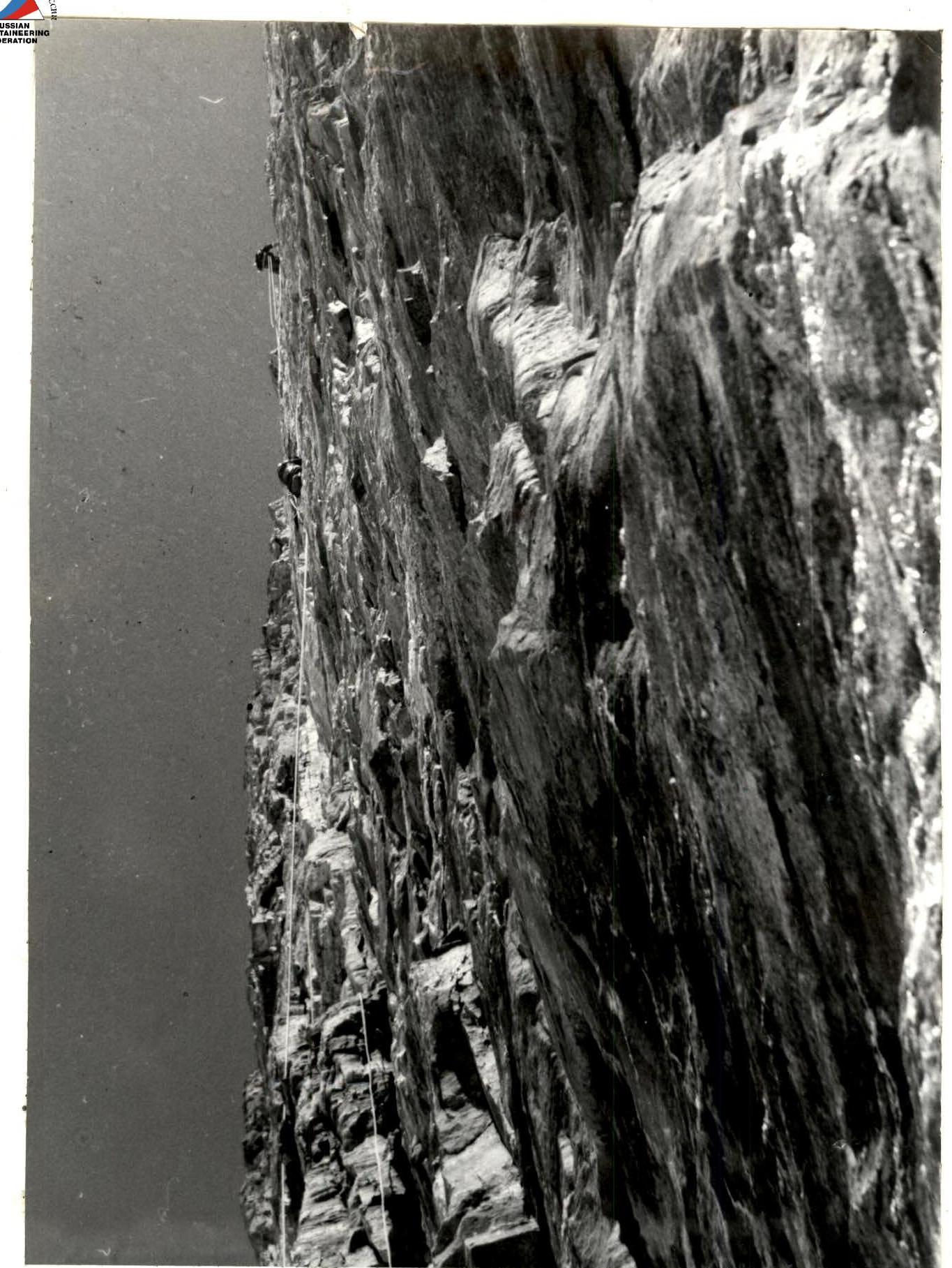
ROUTE DESCRIPTION BY SECTIONS Route landmarks (highlighted on technical photos): "Birdie" — a structural outcrop on the wall, located slightly to the left of the upper part of two giant chimneys, directly above the oval cornice in the center of the wall. "Poker" — a huge structural outcrop on the wall — shaped like a poker, the left part of the outcrop looks polished. Above and below the "poker" are smooth rocks with limited relief and cracks. We called these rocks "mirrors". In the lower third of the wall, the general direction of movement is to the left of the giant chimneys, which are clogged with snow-ice plugs, with water flows at 12° in the chimneys. Section R0–R1. Steep snow slope, intersected by a barrier of slabs, in the area of the barrier and when approaching the wall under the snow — ice. Section R1–R2. Wall with areas of rime ice, complicating the passage of the beginning and end of the section. Section R2–R3. Wall with rime ice lying on slabs, in the middle part of the section — snow on ice (the size of the snow patch significantly decreased during the ascent). Section R3–R4. Wall with rime ice at the base, towards the end of the section, the steepness increases. Exit from left to right to the base of a large icicle in the internal angle. Section R4–R5. Sheer icicle 35 m long. Passage in crampons using "ice hooks" (айс-фифи). Belay possible through pitons and chocks driven or placed in the side walls of the angle. Passage complicated by the chipping of the upper layer of ice. Bypass of the icicle along the rocks is difficult due to the lack of cracks and the presence of cornices on the left and right of the angle. Sections R5–R6, R6–R7. System of walls-slab increasing steepness, in the lower part — rime ice, on ice — snow (in the middle of the snow patch, the thickness of the snow-ice cover is 3–5 cm, under it — a smooth slab exposed by the end of the ascent). Climbing straight through a system of small cornices with few cracks. Sections R7–R8, R8–R9. Movement along an internal angle, which ends with a cornice. Extremely complex climbing, on the right wall of the angle, the relief is smoothed, the cracks are washed out by water, the edges of the cracks are in granite "dust". Exit to the cornice along an unreliable crust covering the main rock. Extremely complex climbing. A bolt piton is driven on the cornice to create ITO. Sections R9–R10, R10–R11. Internal angle leading under the wall. For the first time on the route, there are numerous rock flakes with a reverse stepped structure (like "overhanging steps"). Cracks are mainly in the ceilings of micro-cornices. Two large cornices are bypassed. Extremely complex climbing. Few cracks. Section R11–R12. "Birdie" — an outcrop on the wall. The first absolutely safe, suitable for overnight stay place. On the overnight stay, there are horizontal rock flakes 0.3–0.4 m wide with traces of snow. From the overnight stay, the wall is practically vertical. Sections R12–R13, R13–R14. Movement upwards along not clearly expressed internal angles, to the left is a zigzag-shaped rock flake (landmark on the route). The angles are intersected by cornices with an overhang of up to 1 m. The upper part of section R14 passes through a powerful cornice crossing the entire wall. Passed straight through. Cracks are partly clogged with granite "dust". Quartz inclusions make the rock slippery. Extremely complex relief. Movement mainly on ITO. 1 bolt piton is driven. Section R14–R15. From the cornice, movement along a smooth wall. Cracks on the wall are practically absent. Belay through thin pitons. The 1st climber orients on the top of the zigzag-shaped rock flake. In the area of the top of the flake, on July 31, the team organized a hanging overnight stay. From the flake, movement is only vertically upwards; movement to the left-upwards along oblique rock flakes leads to an overhanging light wall with a structure mainly consisting of quartz. Sections R15–R16, R16–R17. Movement along two internal angles located one under the other. The angles lead under the beginning of a long overhang — a 70-meter "mirror". The angles are intersected by numerous small cornices, the relief is reverse. Extremely complex climbing, use of ITO. Section R17–R18. Smooth sheer wall with cornices and a 2-meter (in height) narrow, blunt crack. Practically no relief. Movement on bolt pitons and "toporki" (a type of thin blade-like chocks). Section R18–R19. Smooth wall with cornices. Narrow blunt cracks. The surface of the wall is covered with a plate-like layer that flakes off when working with a drill. Organization of belay is extremely complicated. Movement on bolt pitons and "skyhooks". Section R19–R20. Movement along an overhanging wall with a cornice at the end, along a thin, blunt crack. Wide use of "skyhooks". The most complex section of the route. Movement only on ITO. For passage, "petals" and thin chocks are used. Section R20–R21. Internal angle with smooth walls. In the angle, a thin, blunt crack. The surface of the rock is slippery due to quartz inclusions. Climbing is extremely complex. Sections R21–R22, R22–R23. Smoothed wall with micro-relief, leading to the base of an internal angle. Movement along the wall on ITO. Use of "skyhooks", work on the "belly" (a section of rock). Psychologically difficult section. Passage of a wide internal angle is complicated by the presence of old granite outcrops covered with "dust". Extremely complex "slippery" climbing. Movement on the right side. The angle leads to a -shaped rock flake "poker", where the team organized a hanging overnight stay on August 1–2. Section R23–R24. From the overnight stay upwards along an internal angle with "live" blocks. Climbing is extremely complex. The choice of cracks for pitons is difficult. The only place on the route with "live" stones. Sections R24–R25, R25–R26. Smooth wall-"mirror", overhanging in the upper part. Thin, blunt cracks. Relief is small. Use of "skyhooks", ITO. Most cracks are clogged with "dust". Movement on "mizers" (very small chocks or pitons). Section R26–R27. Oblique crack on a smooth overhanging wall. The crack is in a quartz vein, repeatedly intersected by reverse rock flakes. Passage only on ITO. The edges of the crack are slippery and crumbling. Section R27–R28. Wall with small relief and a crack. Rocks are slippery due to quartz inclusions, crumbling under load. Extremely complex "slippery" climbing, bypassing a cornice. Sections R28–R29, R29–R30. Smooth slabs with small relief. The surface of the slabs is partly crumbling. Extremely complex climbing, in the upper part — only on ITO. Use of "skyhooks". Section R30–R31. Traverse to the left under a large cornice. Feet on a smooth wall, pitons and chocks "go" into the ceiling and reverse rock flake. In the ceiling, thin cracks. Extremely complex climbing. Only on ITO. Sections R31–R32, R32–R33. System of two internal angles intersected by numerous reverse rock flakes. The surface of the rocks is covered with thin granite plates. Extremely complex climbing. Use of "skyhooks" and bolt pitons is impossible. Section R33–R34. Smooth wall with few holds. Quartz inclusions. A thick layer of "dust" on the rocks. Extremely complex climbing. Sections R34–R35. System of two internal angles with a large cornice (overhang of the cornice up to 2 meters). Cracks in the angle and on its walls are clogged. Passage is possible only after cleaning the rock surface from "dust". Water on the rocks. Extremely complex climbing. Section R36–R37. Wall leading to an ice roof. Steep, wet, smoothed blocks. At the end, exit to ice and traverse 10 m to the right. Exit to the ridge upwards-left is impossible due to the presence of a snow-ice cornice with an overhang of about 3 m. Section R37–R38. Vertical wall covered with rime ice, leading to a corniced ridge and further to the summit (section R38–R39).
 №3. Section R7–R11. From bottom to top.
 №4. Section R5–R6. From top to bottom.
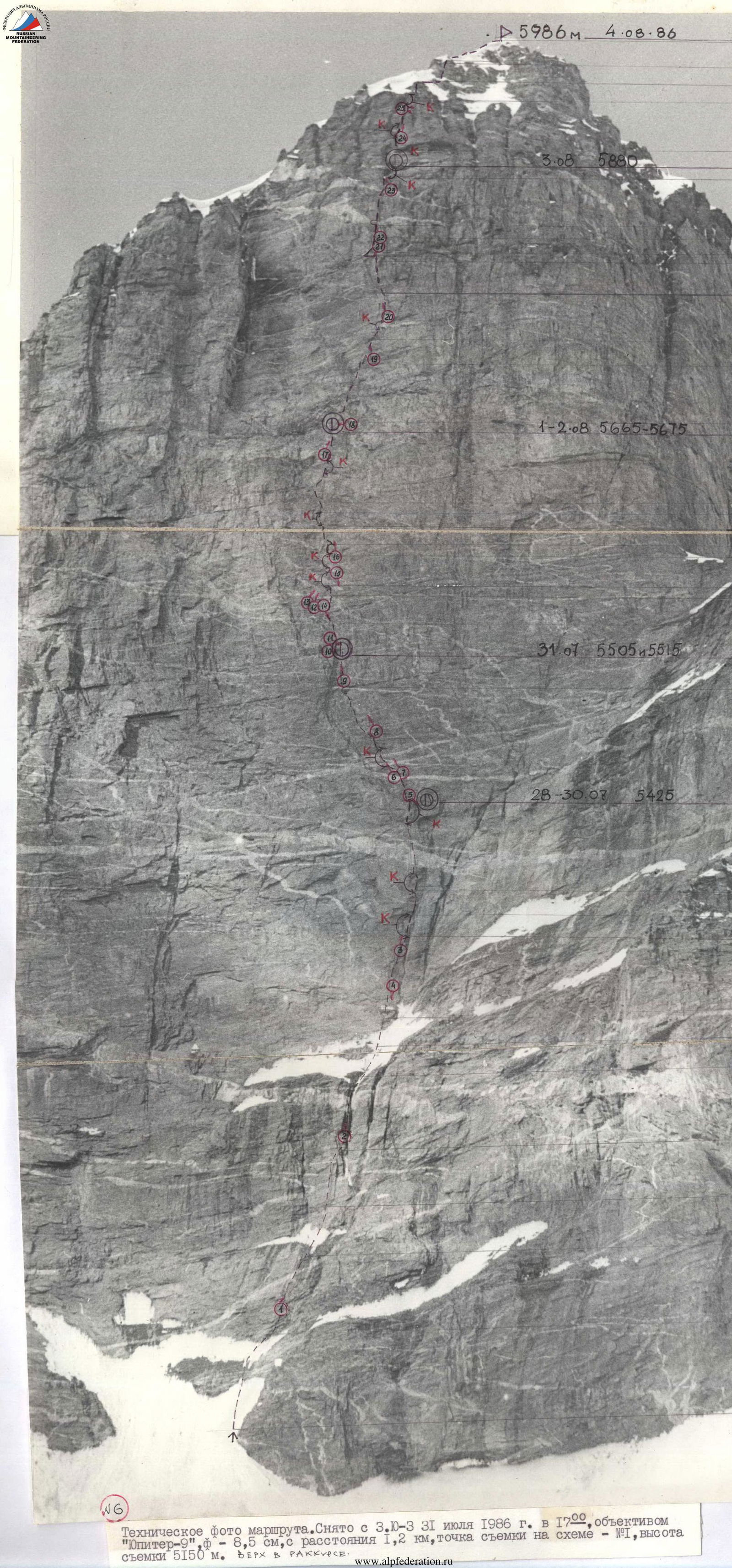 №6. Technical photo of the route. Taken on July 31, 1986, at 5:00 PM, with a "Yupiter-9" lens, f–8.5 cm, from a distance of 1.2 km, shooting point on diagram №1, shooting height 5150 m. Top in perspective.
 №5. Section R11–R12. Overnight stay on the "birdie".
 №8. Cornices on section R12–R13. Taken upwards.
 №9. Section R14–R15. Exit to the rock flake.