PASSPORT
- High-altitude technical class
- Central Pamir, Shahdara Range.
- Peak 5432 via the counterfort of the northwest wall.
- Proposed 5B category of difficulty, first ascent.
- Elevation gain: 1210 m, route length: 1510 m.
Length of sections with 5–6 category of difficulty: 325 m. Average steepness of the route: 54°.
-
Pitons driven: rock 96 (8), chocks 73 (6), ice screws 4
-
Team's total climbing hours: 26.5, and days – 3.
-
Overnight stops: 1st — on the counterfort ridge — lying down, 2nd — on a rocky ledge, partially hewn in a snow-ice ridge, lying down.
-
Leader: Sergey Poyda, CMS Participants: Valery Savchenko, CMS Vitaly Buzmakov, 1st sports category Elena Radina, 1st sports category Boris Mednik, 1st sports category
-
Coach: Yuri Razumov, MS
-
Route start: July 6, 1985. Summit: July 8 Return: July 8.

Photo 1. General photo of the summit. Taken from Desyati Pass (4400 m) on July 5, 1985, at 15:00. Distance 4 km, lens T.43 4/40. Shot No. 1.
VCSPS ALL-UNION VOLUNTARY SPORTS ORDER OF LENIN SOCIETY "SPARTAK" LENINGRAD CITY COUNCIL Leningrad, 197047, Vyazovaya st., 10 Tel. 235-02-07 Checking account 18000700762 in the Petrograd branch of the State Bank of Leningrad No. 117 October 30, 1985.
To the Classification Commission of the USSR Alpine Federation
The bureau of the alpine section of the Leningrad City Council of the Spartak Sports Society petitions for the assignment to Peak 5432, for which the first ascent was made in honor of the anniversary of the Spartak Sports Society, of the nominal name "Peak 50th Anniversary of Spartak". A corresponding petition has been sent to the Presidium of the Supreme Council of the Tajik SSR.
Senior coach of the Leningrad City Council for mountaineering Novgorodtseva G.P.
1312–10 000 May 12, 1983. Typ. LOSPS
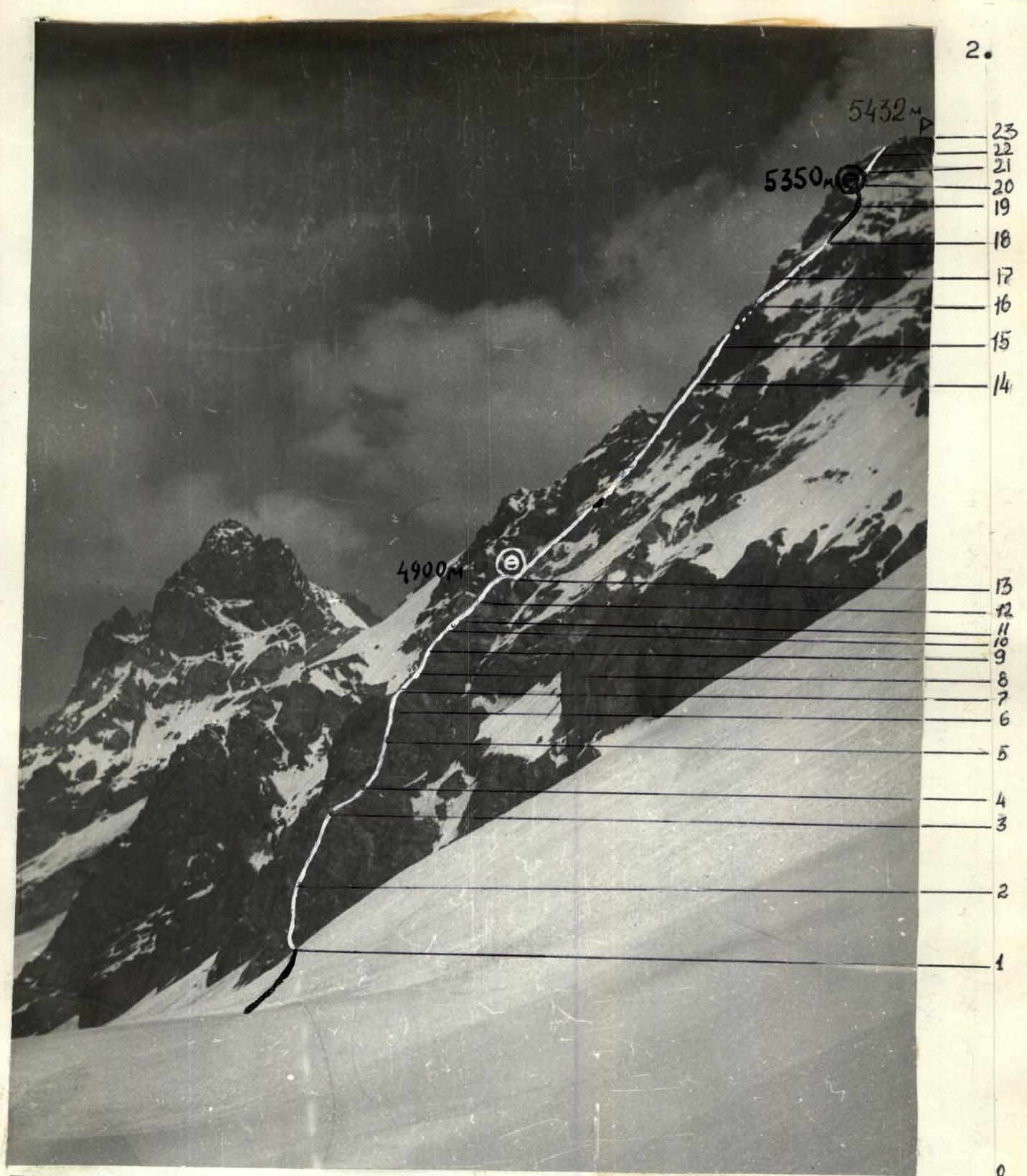
Photo 2. Profile of the NW wall of Peak 5432. Taken during the descent from Slavutich Pass. (V.4400 m) on July 8, 1985, at 14:00. Lens T.43 4/40. Shot No. 2.
Photography of the route profile from the left was not carried out as the group did not have enough time to reach a suitable vantage point.
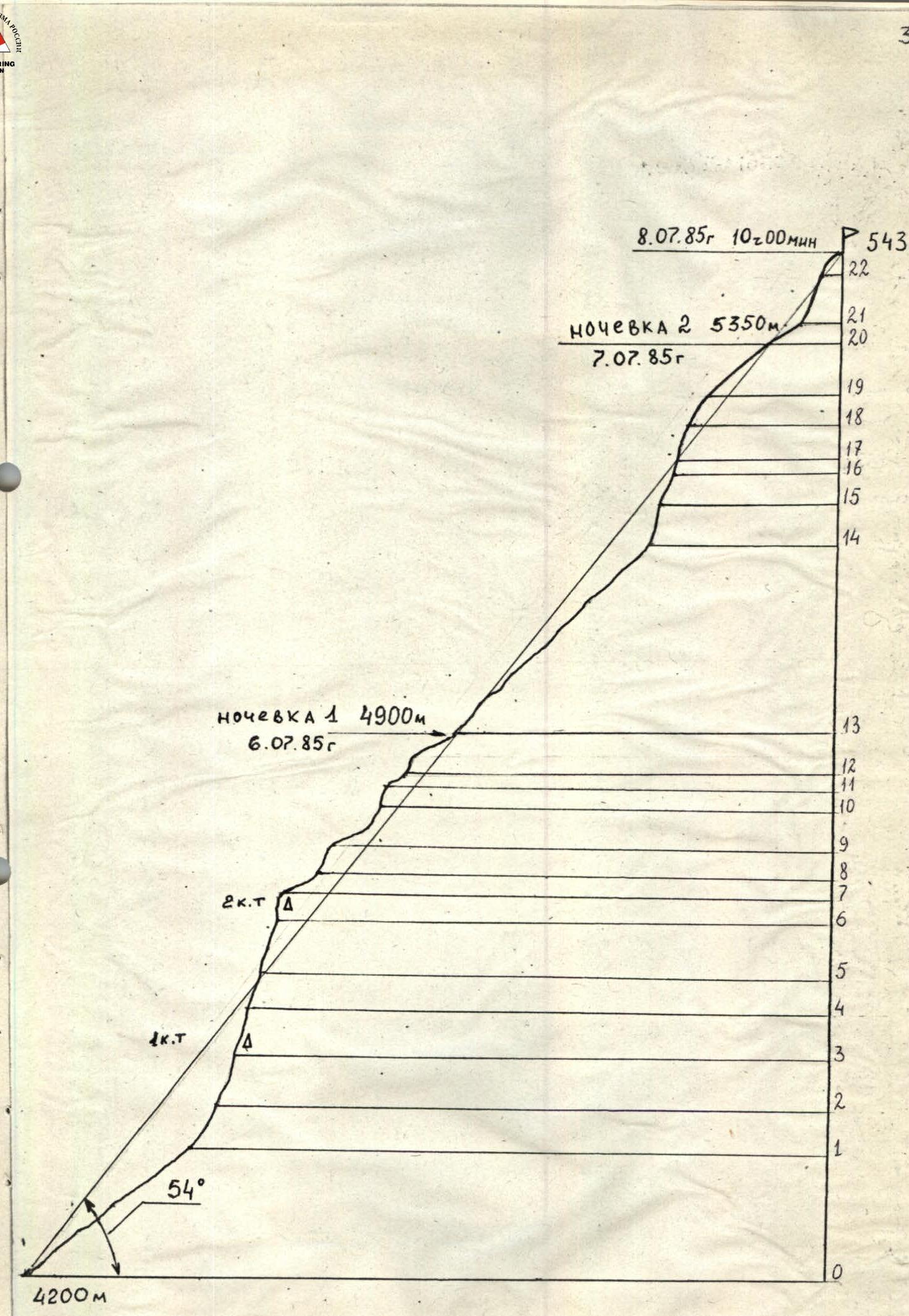
ROUTE PROFILE M 1:5000
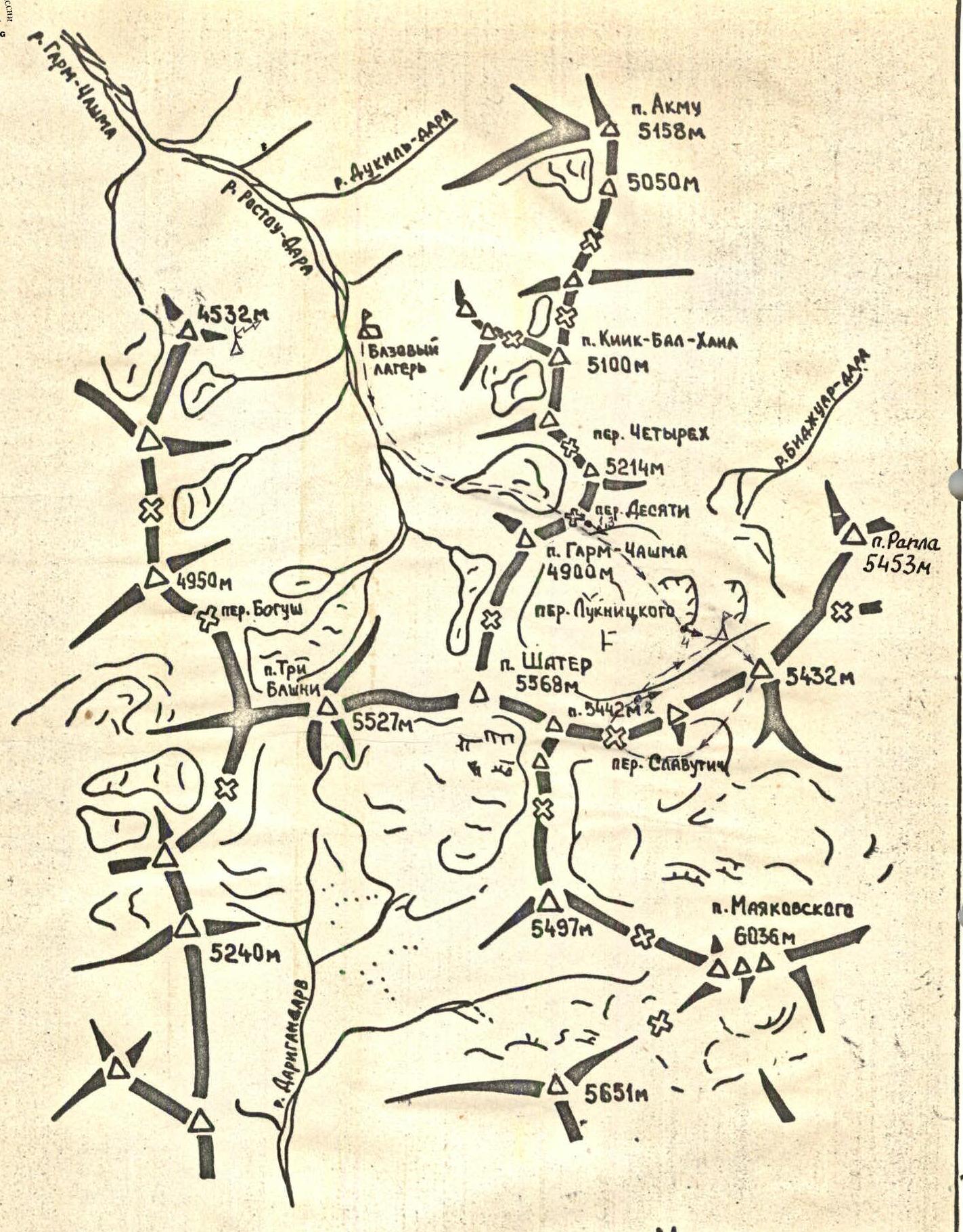
AREA MAP-SCHEME OF THE ASCENT.
δ — storm camp δ — repeater → — photo shooting points
BRIEF REVIEW OF THE ASCENT AREA.
Peak 5432 m is located in the northwestern part of the Ishkashim Range, in the ridge separating the valleys of the Bidzhuar-Dara and Lyadzhvar-Dara rivers. To the northwest, the peak faces a one-and-a-half-kilometer wall into the upper reaches of the Bidzhuar-Dara river, with a pronounced counterfort from the foot to the summit.
At the confluence of the Garm-Chashma river with the Pyanj river lies the village of Anderob, and almost a kilometer upstream — the village of Garm-Chashma, a water resort and a sanatorium of republican significance. A good asphalt road leads here, and a bus runs from Khorog once a day (45 km). A good trail leads into the upper valley from the village (30 km) – 8–9 hours of walking, to the middle of the valley it goes through wooded terrain, and further along the high-altitude trail along the river to the base camp, located on the right (orographic) bank of the Garm-Chashma river, in its upper reaches. In the middle reaches of the river, there are several koshs where one can hire donkeys for a caravan.
Our team, as part of the Leningrad City Sports Committee gathering, used a helicopter for cargo and equipment transportation, which made two flights from Khorog to the base camp, located in a large clearing under the cover of a large stone moraine (height 3600 m). The participants walked on foot from the village of Garm-Chashma. The approach to the route followed the right (orographic) bank of the Garm-Chashma river to the foot of Peak Shater (5568 m), then left of Peak Garm-Chashma (4900 m), through the Desyati Pass into the Bidzhuar-Dara cirque (4–4.5 hours), from there to the foot of Peak 5432.
Climatic conditions at the beginning of this season were not favorable for ascents. Frequent rains and snowfalls at the top significantly complicated the routes.
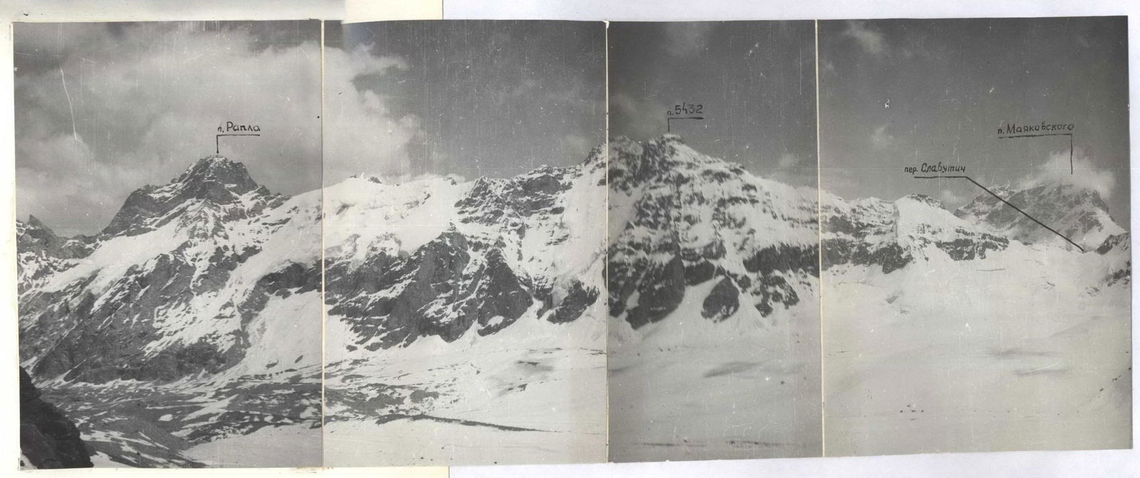
Photo 3. Panoramic photo of the area. Taken from Desyati Pass (4400 m). Distance 4 km. Lens T.43 4/40. Shot Nos. 1, 3.
TACTICAL ACTIONS OF THE TEAM.
The tactical plan for the ascent involved solving a number of tasks and was largely adhered to.
Planned bivouac sites were used, meaning that almost the entire route was covered in a day.
Movement along the route was organized according to the principle of a constant lead rope-team, with the lead climber working with a light backpack, removing it in the most challenging sections, followed by a rope-team of three on the processed route.
Up to the second control point (sections R0–R7), Sergey Poyda worked first, from the second control point to the summit, Vitaly Buzmakov.
The movement tactic on the route was chosen based on the difficulty of the sections and belay conditions. Independent movement of rope-teams was used, utilizing belay elements left by the preceding rope-team (sections R0–R1; R6–R7; R10–R11; R12–R13; R22–R23), movement with interaction between rope-teams, where the first climber, having passed a section, organized a top belay for their partner and the first climber of the second rope-team (sections R8–R9; R13–R14; R17–R18; R18–R19; R19–R20), movement on fixed ropes (sections R1–R6; R7–R8; R9–R10; R11–R12; R14–R15; R15–R16; R16–R17).
A wide range of rock and ice pitons, chocks allowed for reliable belays along the entire route, and a thorough study and selection of the route minimized the likelihood of the group being hit by rockfall or avalanche in the lower part of the route.
The first bivouac, located on a flattened part of the counterfort ridge, was convenient and safe. The organization of the second bivouac under the pre-summit tower required some time to prepare a flat area on a sloping snowy part of the counterfort. The bivouacs were located on spacious areas, and no additional belays were required.
Thanks to thorough belaying and high individual technical skill of the participants, there were no falls or injuries on the route.
Radio communication via the "Lastochka" radio station with the base camp was maintained through a repeater on the slope of Peak 4532 m and was stable throughout the ascent.
The initially planned descent towards Slavutich Pass proved to be difficult and unsafe upon inspection from the summit. The descent from the summit was carried out along a snowfield and simple rocks in the lower part into the cirque of Peak Mayakovsky (6036 m) and further through Slavutich Pass back to the bivouac under the start of the route.
Summary data on piton usage and team's climbing hours:
| Rock | Chocks | Ice screws | Team's climbing hours | Days |
|---|---|---|---|---|
| 96 (8) | 73 (6) | 4 | 26.5 | 3 |
Route scheme by sections (summary table):
| Section | Length, m | Steepness, ° | Category | Notes |
|---|---|---|---|---|
| R0 | 220 | 40 | 3 | |
| R1 | 50 | 60 | 5 | |
| R2 | 40 | 80 | 5 | |
| R3 | 40 | 70 | 5 | July 6, 1985, 10:43 |
| R4 | 60 | 80 | 5 | |
| R5 | 20 | 90 | 5 | |
| R6 | 40 | 30 | 3 | |
| R7 | 25 | 70 | 5 | July 6, 1985, 14:30 |
| R8 | 60 | 45 | 2 | |
| R9 | 20 | 80 | 5 | |
| R10 | 20 | 30 | 3 | |
| R11 | 20 | 65 | 5 | |
| R12 | 40 | 30 | 3 | |
| R13 | 280 | 45 | 4 | July 7, 1985, 8:43; July 6, 1985, 20:43; 88K |
| R14 | 40 | 80 | 5 | |
| R15 | 40 | 65 | 4 | |
| R16 | 10 | 85 | 5 | |
| R17 | 30 | 60 | 4 | |
| R18 | 80 | 40 | 4 | |
| R19 | 40 | 30 | 3 | July 8, 1985, 9:40; July 7, 1985, 21:46; 12:54 82k |
| R20 | 40 | 40 | 3 | |
| R21 | 40 | 70 | 4 | |
| R22 | 60 | 30 | 3 | July 8, 1985, 10:20 |
| R23 |
From the bivouac along the glacier with a gradual increase in steepness, somewhat right of the counterfort ridge.
DESCRIPTION OF THE ROUTE BY SECTIONS.
R0–R1 Ascent to the start of the rock route on the right part of the counterfort along a snow-ice cone with a steepness of 40°. Then 40 m traverse (ice) left to a rocky ledge. The section is prone to snow and rockfall. Along the ledge 50 m left.
R1–R2 Upward ascent through severely destroyed rocks to an internal corner, the beginning of which is blocked by a large overhanging rock (Photo 5).
R2–R3 From under the overhang (artificial holds) along the right part of the internal corner, exit to the shoulder of the counterfort (Photo 6). Installation of the 1st control cairn. Steepness 80°.
R3–R4 Along the internal corner (70°) through severely destroyed rocks, exit to a rocky ledge.
R4–R5 Along the ledge right 30 m to the start of a wall. Up the wall (limited holds, artificial holds, steepness 80°) to the start of a chimney (Photo 8).
R5–R6 Up the chimney 20 m (90°) to a wide rocky ledge.
R6–R7 Along the ledge left upward 40 m to the shoulder of the counterfort. 2nd control cairn. A place suitable for a bivouac. Along the destroyed rocks of the counterfort, approach to a wall.
R7–R8 Up the wall (70°) 25 m straight up, exit to an inclined rocky ledge.
Along the internal corner (70°) exit to inclined slabs.
R8–R9 Up the slabs 40 m to a destroyed wall (45°) and along it 20 m to the start of an internal corner.
R9–R10 Along the internal corner 20 for a complex climbing section (80°), exit to simple destroyed rocks on the counterfort ridge.
R10–R11 Along simple destroyed rocks to a wall.
R11–R12 Up the wall straight 20 m (65°), exit to simple rocks.
R12–R13 40 m along simple rocks to the 1st bivouac. Simultaneous movement.
R13–R14 Movement of rope-teams along simple rocks on the ridge independently, 280 m. Steepness 45°. Exit to a steep rock wall.
R14–R15 To the left of the wall along an internal corner ending in an overhang. Rocks are iced. First climber in crampons, difficult climbing, artificial holds. Movement on fixed ropes with two jammers. Exit to iced rocks on the left part of the counterfort ridge. Photo B.
R15–R16 Along the left part of the ridge, with small ice sections, exit to a wall.
R16–R17 Up the wall straight 10 m (85°). Limited holds, exit to the counterfort ridge.
R17–R18 Along the ridge 30 m (60°), exit to snowy "ram's foreheads" interspersed with steep snow ledges.
R18–R19 Along the "ram's foreheads" and ledges 80 m (40°) (to the right — avalanche danger), exit to the pre-summit tower.
R19–R20 Traverse along snow 60 m left. Safe bivouac on a snowy ridge of the counterfort.
R20–R21 Along simple rocks (40°) exit to a rock wall of the summit tower.
R21–R22 Up the wall 40 m (70°) exit to a snowy pre-summit ridge Photo 9.
R22–R23
Along gentle snow 60 m right to the summit.
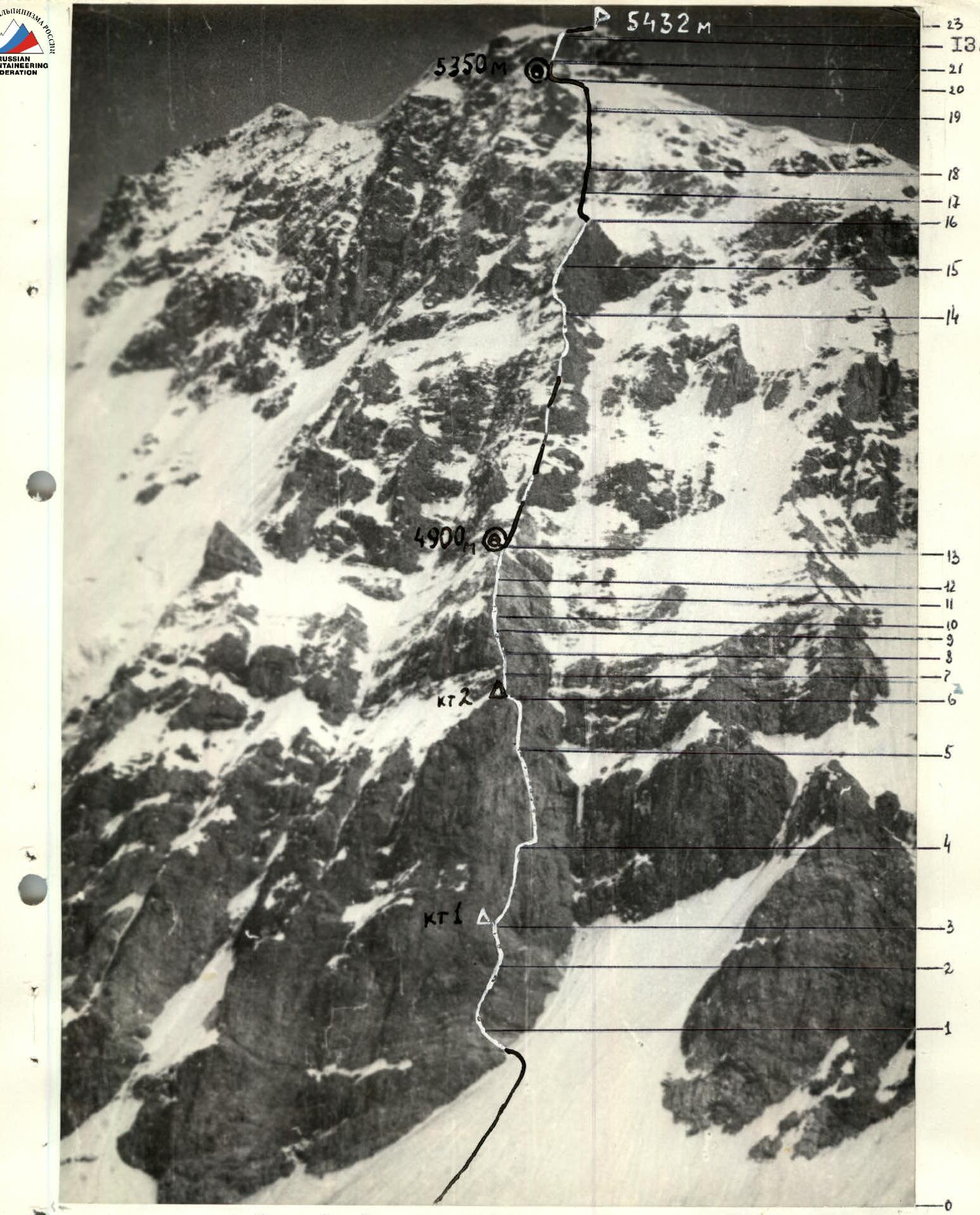
Photo 4. Taken from the cirque of the summit on July 5, 1985. Distance 1.5 km. Lens T.43 4/40. Shot No. 4. Height 4200 m. Time 16:00