Report on the First Ascent in the 1973 USSR Alpine Championship
on the peak 5497 m via the northwest wall by the team of the Ukrainian Committee for Physical Culture and Sports
From June 14 to June 23, 1973, under the leadership of Grigorenko-Prigoda Yu.I.
Brief Geographical Description and Sporting Characteristics of the Object
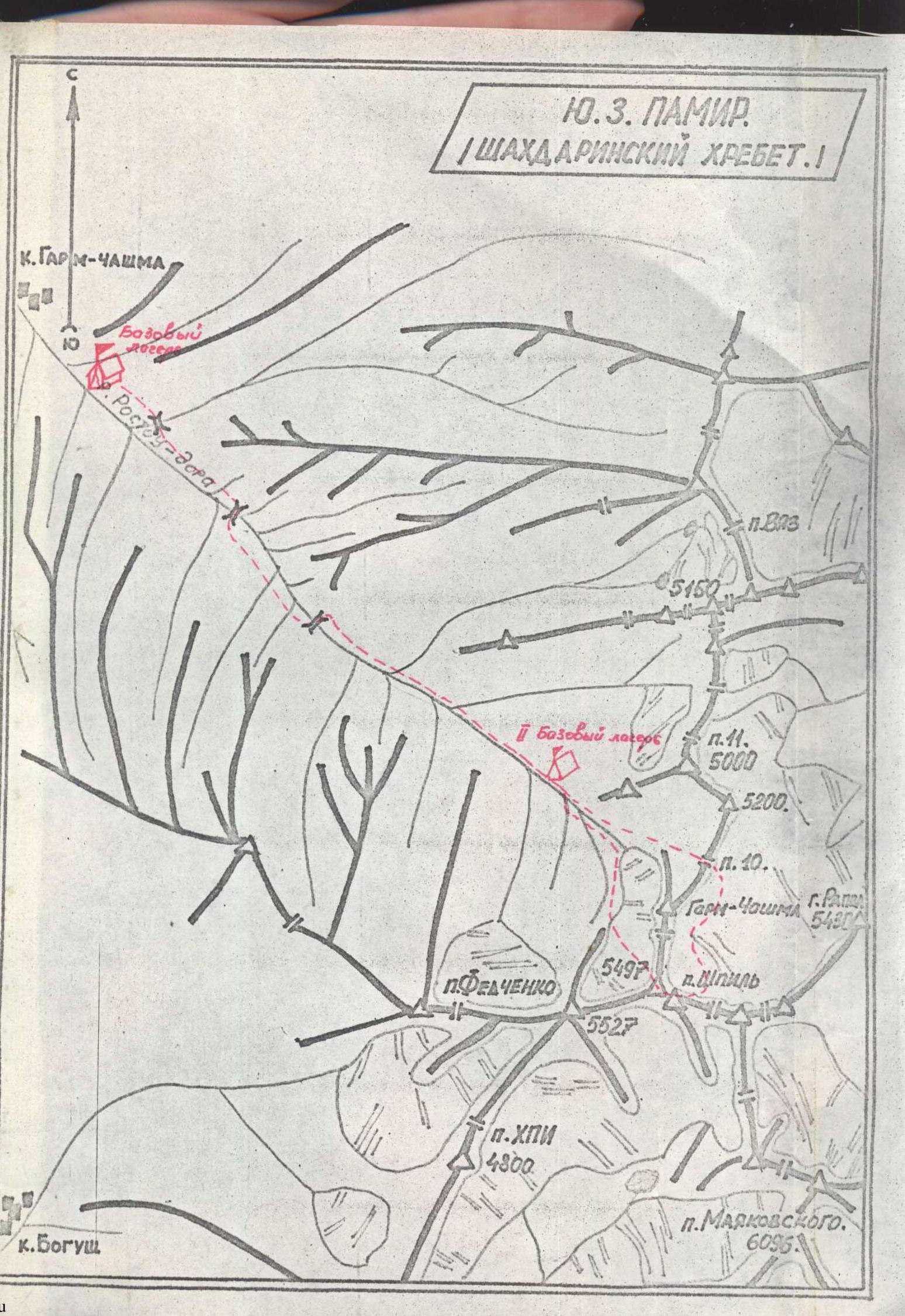
Peak 5497 m is located in the upper reaches of the Garms-Chashma river. The first researcher of this region was botanist B.A. Fedchenko, who visited in 1904, but his research was not published. In 1931, P. Luknitsky, a Pamir researcher and participant in the Tajik complex expeditions, visited the upper reaches of the Garms-Chashma river. He made drawings and drew attention to the massif, which he called "Shatert" (Tent). The "Shatert" massif has two peaks on the left and three prongs on the right. Nearby, to the south, lies the peak Mayakovsky (photo). The area around peak Mayakovsky has been explored by alpinists, but the upper reaches of the Garms-Chashma river remained uncharted. Tourists from Kiev explored this region, made first ascents of several passes, and climbed peak Garms-Chashma (1B category). The peak is located along the ridge next to the "Shatert" massif. In 1971, the Ukrainian Council of Tourism organized a tourist expedition to the Garms-Chashma river region and invited alpinism instructors V.S. Shumikhin, V.S. Tkachenko, A.I. Vseljubsky, V.A. Bakhtigozin, and others. Concurrently, an alpinist expedition from Kharkov worked in the area. During this period, several first ascents of categories 1, 2, and 3 were made, and a detailed reconnaissance of the wall on the left part of the "Shatert" massif to peak 5497 m was conducted.
Results of the reconnaissance:
- the wall has a height difference of approximately 1800 m;
- the steepness of the wall is around 90°, with the upper part being even steeper;
- the wall is prone to rockfall, but a passable route exists.
Conclusions after the reconnaissance:
The wall can be ascended, but it's advisable to attempt it when the wall is snow-covered and rockfall is less frequent. This period corresponds to the beginning of the summer season, in June.
Route Description
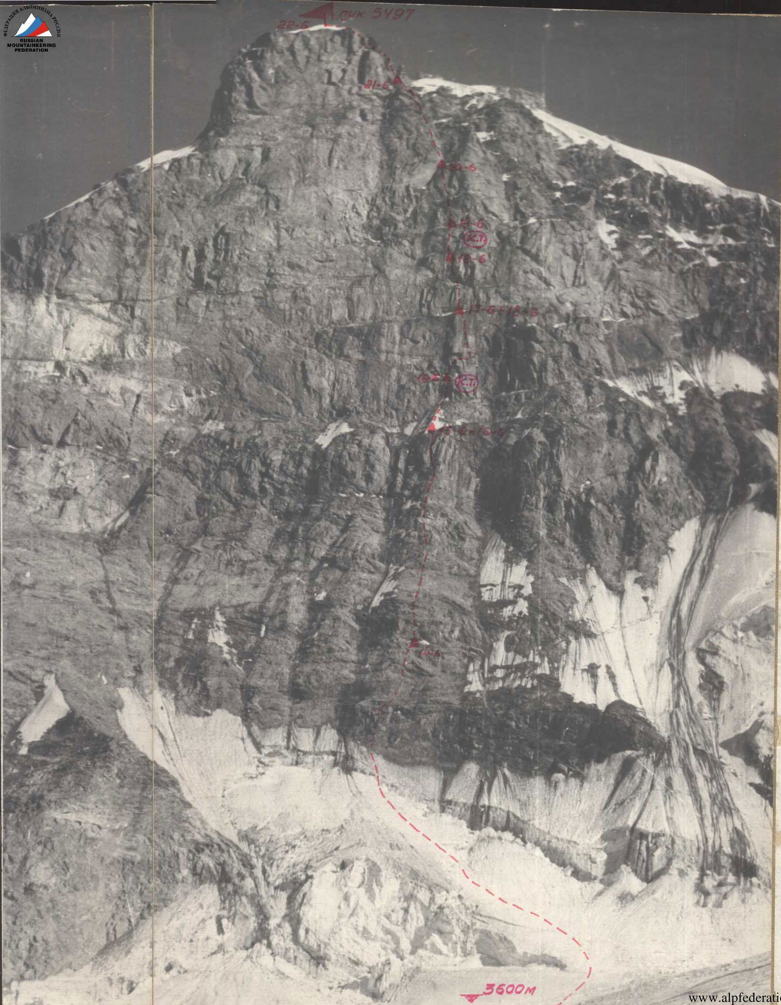
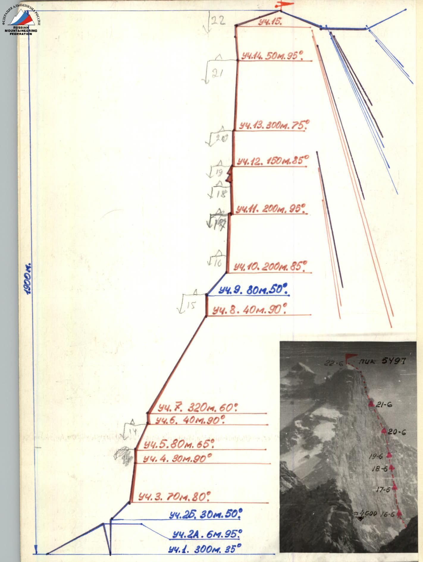
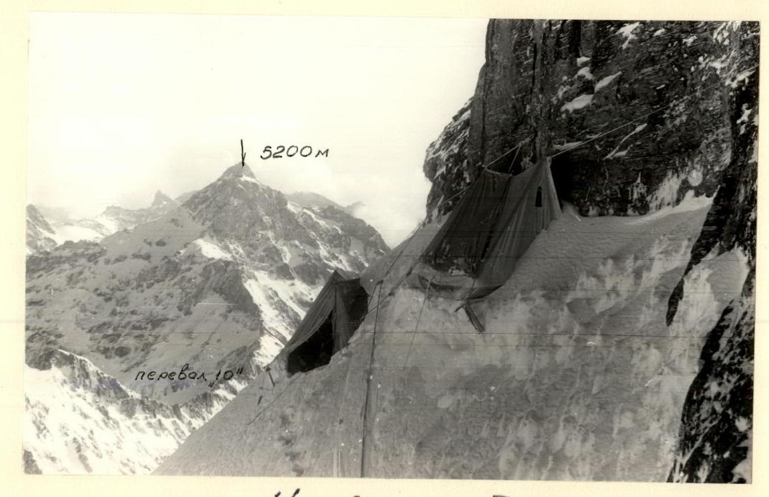
A safe and convenient bivouac can be set up on a large rocky outcrop below the base of the wall on the glacier. The route begins on the ice slope towards a not clearly defined counterfort in the center of the wall. The bergschrund, 40–50 m from the rocks, is crossed by descending onto a "plug" and then ascending the opposite, negative wall (5–6 m). After the bergschrund, the slope has a steepness of 50–55°. The counterfort starts with a steep 100 m wall (R4), the upper part of which is complicated by small negative sections (1.5–2 m). Further ascent follows steep, crumbling rocks under a large cornice, where a safe overnight stay is possible. It's not recommended to deviate to the right due to increased rockfall danger. The large cornice is bypassed on the left via a steep 30 m slab requiring complex climbing with artificial aids (R6). Further, the route follows ice-covered slabs—320 m (R7). The ascent continues up a vertical internal angle 40 m (R8) to reach the firn slope under the bastion. The "living" slab in the upper part of the angle is bypassed on the right. At the start of the firn slope, a relatively safe overnight stay is possible. The route follows a distinct ridge on the firn slope towards the bastion—80 m—and then continues up the wall 200 m with difficult climbing to a small ledge under a 50-meter overhang (R10). The first control cairn is on this ledge. A sitting bivouac is possible. Further ascent follows a vertical internal angle to a ledge covered in ice, and then rightwards and upwards (bypassing the overhang) to the next ledge, which is convenient and safe for an overnight stay (R10). The further route passes up a vertical 200-meter wall with two cornices. The entire wall is climbed using artificial aids, and the cornices are faced head-on (R11). There are no suitable places for an overnight stay on this section. After the second cornice, a prone bivouac is possible on a small ledge. From the ledge, the route follows a smoothed, steep wall (R12). Climbing is complicated by loose hanging blocks that need to be bypassed using artificial aids. Belaying and pulling up backpacks is done using ladders. A sitting bivouac is possible. Further, the route goes leftwards and upwards along the wall 300 m towards the summit (R13). Before a looming section of the wall, a sitting bivouac is possible. The final 50 m before reaching the summit dome have a negative incline. Pulling up backpacks is complicated by sharp rocks under the top of the wall.
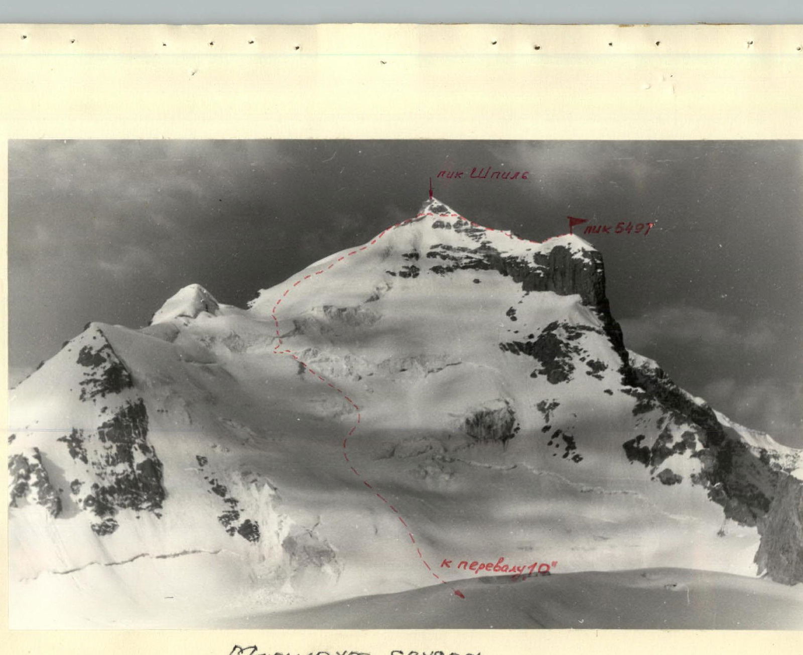
The summit is reached via a snowy slope. Due to the lack of a safe descent route from the summit 5497 m, the descent must be made via the peak Shpil following a route of approximately category 4A difficulty, which was ascended this year by one of the expedition groups.
Daily Route Log
1st day (June 14, 1973) Approach to the route. Climbed a snowy slope (R1), crossed the bergschrund (R2), ascended an ice slope (R2), and climbed the lower part of the counterfort (R3–R5). 2nd day (June 15) Climbed a rocky wall (R6), ice-covered slabs, and an internal angle (R7–R8). 3rd day (June 16) Climbed a firn ridge (R9) and 50 m of rocky wall (R10). Two people spent the night sitting on a ledge at the end of the last rope, while the remaining three stayed at the previous bivouac. 4th day (June 17) Climbed 150 m of rocky wall (R10). 5th day (June 18) Climbed 120 m of rocky wall (R11). Two people spent the night in hammocks under a cornice, while three stayed at the previous bivouac. 6th day (June 19) Climbed 80 m of wall with two cornices (R11). 7th day (June 20) Climbed 150 m of rocky wall (R12). 8th day (June 21) Climbed 300 m of rocky wall (R13). 9th day (June 22) Climbed a 50 m negative wall and reached the summit 5497 m via a snowy ridge. 10th day (June 23) Traversed the ridge to peak Shpil and descended to the base camp via a route of category 4A difficulty through the "Desyati" pass.
Route Assessment
The route to peak 5497 m via the northwest wall is technically challenging and distinguished by its length and complexity. The wall can be divided into two sections, each with its specific characteristics: the lower part of the wall with a not clearly defined counterfort, and the bastion (upper part of the wall, starting from its midpoint). The significant length, abundance of cornices, negative sections, and the characteristic friability of eroded rocks make the bastion very challenging to ascend. The total length of category 6 sections is approximately 600 m. The route is logical and relatively safe (during this time of year) as it ascends vertically up the not clearly defined counterfort and then under the protection of the generally overhanging bastion. Considering the experience of previous ascents of category 6A and 5B difficulty and comparing this route to those listed below, the team members believe that the route corresponds to category 6B difficulty.
Experience with Technically Challenging Climbs
- Ushba, NW wall: 6B
- Ushba, NW wall (Artsishevsky's route): 6A
- Chatyn, "romb" (diamond): 6B
- Chan Chakhi, N wall: 6A
- Songuti, SE wall: 5B
- Mamisontkhok, left edge: 5B
- Mamisontkhok, "treugolnik" (triangle): 5B
- Bashkara, N wall (via "zeckals"): 5B
- Shkhelda 3rd western peak (via "rybka"): 5B
- Shurovsky peak (via "bastion"): 5B
- Domбай peak: 5B
- Mechta peak: 5B
- Passionarii peak: 5B
- Uilpatakhok: 5B
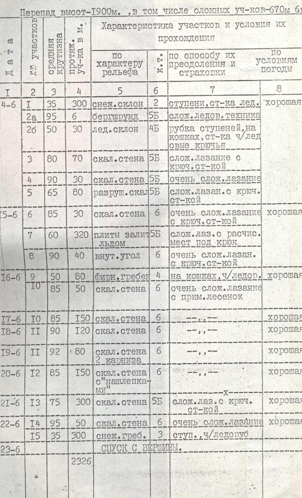
Table of Main Route Characteristics Height difference—1900 m, including 670 m of category 6 difficulty.
Ascent Route: Peak 5497 m via NW wall, SW Pamir Average steepness—80°
| Date | Section | Length (m) | Steepness (°) | Terrain Character | Diff. Cat. | Method of Ascent and Belay | Weather Conditions | Bivouac | Departure | Time Taken | Rock Hooks | Ice Hooks | Shлям Hooks | Bivouac Conditions | Daily Ration Weight |
|---|---|---|---|---|---|---|---|---|---|---|---|---|---|---|---|
| 14.06 | R1 | 300 | 35 | snowy slope | 2 | steps, ice axe belay | good | 9 | 10 | 11 | 4 | ||||
| 14.06 | R2А | 6 | 95 | bergschrund | 5 | complex ice climbing | 7 | ||||||||
| 14.06 | R2Б | 30 | 50 | ice slope | 4 | step-cutting, crampons, belay via ice axe, ice hooks | 4 | ||||||||
| 14.06 | R3 | 70 | 80 | rocky wall | 5 | difficult climbing with hook belay | 17 | ||||||||
| 14.06 | R4 | 30 | 90 | rocky wall | 5 | very difficult climbing | 15 | ||||||||
| 14.06 | R5 | 80 | 65 | crumbling rocks | 5 | difficult climbing with hook belay | 19 | 15 | 12 | lying down | 1,2 | ||||
| 15.06 | R6 | 30 | 85 | rocky wall | 6 | very difficult climbing with hook belay | good | 8 | 14 | ||||||
| 15.06 | R7 | 320 | 60 | ice-covered slabs | 5 | difficult climbing with clearing for hooks | 55 | 6 | |||||||
| 15.06 | R8 | 40 | 90 | internal angle | 6 | very difficult climbing with hook belay | 18 | 10 | 13 | lying down | 1,2 | ||||
| 16.06 | R9 | 80 | 50 | firn ridge | 4 | crampons, ice axe | good | 7 | |||||||
| 16.06 | R10 | 50 | 85 | rocky wall | 6 | very difficult climbing with ladder use | 20 | 13 | 37 | 3 on old, 2 on new, sitting | 1,2 | ||||
| 17.06 | R10 | 150 | 85 | rocky wall | 6 | --- | good | 19 | 8 | 11 | 84 | lying down | 1,2 | ||
| 18.06 | R11 | 120 | 90 | rocky wall | 6 | --- | good | 18 | 8 | 10 | 35 | 2 | 6 | 2 hanging, 3 on old | 1,2 |
| 19.06 | R11 | 80 | 92 | rocky wall with 2 cornices | 6 | --- | good | 19 | 8 | 11 | 85 | 3 | 4 | lying down | 1,2 |
| 20.06 | R12 | 150 | 85 | rocky wall with "nashlepka-mi" | 6 | --- | good | 17 | 8 | 9 | 64 | sitting | 1,0 | ||
| 21.06 | R13 | 300 | 75 | rocky wall | 5 | difficult climbing with hook belay | good | 20 | 7 | 13 | 52 | sitting | 1,0 | ||
| 22.06 | R14 | 50 | 95 | rocky wall | 6 | very difficult climbing | good | 5 | 55 | 2 | |||||
| 22.06 | R15 | 300 | 35 | snowy ridge | 3 | steps, ice axe | 20 | 15 | lying down | 1,0 | |||||
| 23.06 | DESCENT FROM SUMMIT | ||||||||||||||
| TOTAL | 2326 | 107 | 538 | 22 | including those placed at bivouacs, for pulling up backpacks, and for belay anchors. | 12 |

Bivouac on 17.06 after a night snowfall.
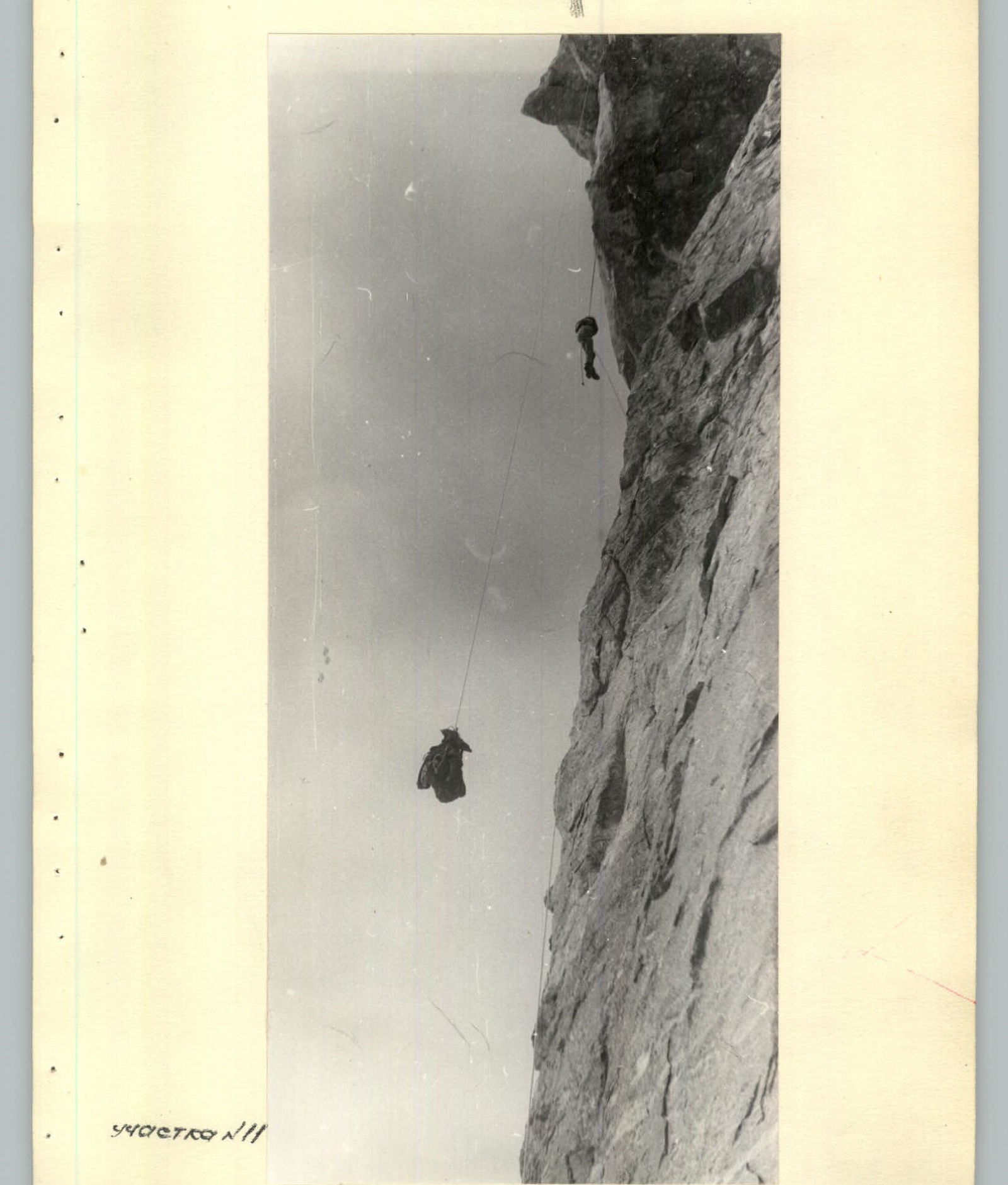
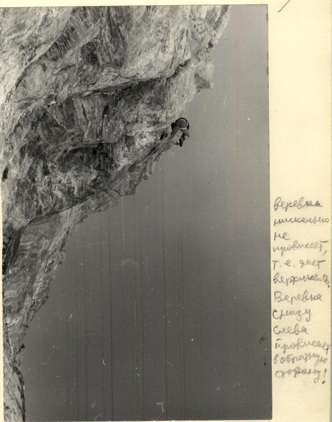
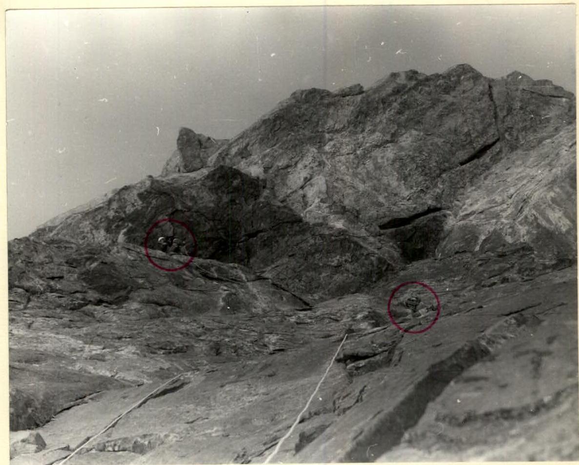 Working moment of processing the first cornice (section R11)

Ascent Footage